Showing 355 items
matching forest st.
-
 Federation University Historical Collection
Plan, R. Underwood, Shire of Winchelsea, 1952, 10/10/1952
Copy of a plan of the Shire of Winchelsea including Lake Wollard, Wormbete, angahook, boonah, Barwon Downs, Kaanglang, St Gerge River, Cumberland Creek, Stony Creek, Bambra, Wensleydale, yan Yan Gurt, Tutegong, Mirnee, Karngun, whoorel, Birregurra, Barwon River, Thompson's Creek, Bass Straight. Mt Defiance, Mt St George, Loutit Bay, Airey's Inlet, Salt Creek, Mathew's Creek.winchelsea, lake wollard, wormbete, angahook, boonah, barwon downs, kaanglang, st george river, cumberland creek, stony creek, bambra, wensleydale, yan yan gurt, tutegong, mirnee, karngun, whoorel, birregurra, barwon river, thompson's creek, bass straight. mt defiance, mt st george, loutit bay, airey's inlet, salt creek, mathew's creek, r. underwood, why river, point sturt, barwon downs, forest -
Federation University Historical Collection
Reports, Big Cat sightings (dates), 1989
Research of dated sightngs of Big cats in Victoria from 1868-1989. australian mythical animals collection, david waldron, dse, big cats, panthers pumas, nuggety, gippsland, black cats, tasmanian tiger, marysville, wood's point, thylacine, south gippsland, felid, gippsland big cat, kelvin healey, peter hall, sherbrooke forest, woodside, walaces flat, mountain lion, heyfield, mt taylor, walhalla, mt selma, warrnambool, kyneton, korumburra, canadian forest, grampians, panton hill, beaconsfield, apollo bay, forrest, victoria valley, rapanyup, dargo, inglewood, doncaster east, tidal river, cape bridgewater, walkerville, dooen, st arnaud, lake bung bong, mitta mitta, moliagul, emerald, kinglake, cape otway, dereel, leonard's hill, daylesford, korweinguboora, lal lal, noojee, eltham, lancefield, trentham, daisy hill, tanjil south, wonthaggi, cockatoo, warrenheip, greendale, howqua, lake buchan, melville caves, portland, mt elephant, morwell, navarre, yarram, yandoit, moonambel, maryborough, taravale, coghill's creek, trentham, carisbrook, inglewood, warrenmang, yarragon, creswick, emerald, stawel, clunes, majorca, heathcote, talbot, daylesford, newham, broadford, peter chapple -
 Federation University Historical Collection
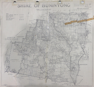
Map, Shire of Buninyong, c1970
The Shire of Buninyong was located on the southern side of Ballarat.Two maps of the Shire of Buninyong. .1) Map showing the County divisions, township boundaries, Railway line, State Forest boundary, riding boundary and shire boundary. Identifying words have been added in red and green texta. .2) Shire of Buninyong Parish Plan. Includes Buninyong, Clarendon, Narmbool, Enfield, Lychfield, SCotchman's, Navigators, Warrenheip, Scotsburn, mr Doran, Durham Lead, Cambrian Hill, Napoleons, Garibaldi, Mt Clear, Lal Lal, Bonshaw.1) B.I.A.E., St Martin's, cemetery, mt Buninyong, mt Innes, rly stn shire of buninyong, buninyong, clarendon, narmbool, enfield, lychfield, scotchman's, navigators, warrenheip, scotsburn, mt doran, durham lead, cambrian hill, napoleons, garibaldi, mt clear, lal lal, bonshaw, state forest, elaine, elaine north, cargerie, grenville, mt mercer, millbrook, wallace, yendon, canadian, kaolin deposits, mount helen campus -
 Federation University Historical Collection
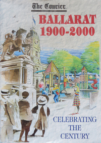
Magazine - Newspaper Supplement, The Courier: Ballarat 1900-2000, 2000
98 page newspaper supplement celebrating the century 1900-2000. Includes 100 names of great Ballaratians.the courier, ballarat courier, anniversary, century, steve bracks, tom o'meara, bruce morgan, weston bate, r.f. scott and co, camerons, sunshince train crash, nellie melba, queen victoria's death, star of the east gold mine, sebastopol, phoenix foundry closure, duke of cornwall and york, duchess of cornwall and york, central highlands water, electric trams, workld war one, richard w. richards, dick richards, william dunstan, mccann's dairy centre, conscription, george merz, peace, avenues of honur, red cross, james oddie, henry sutton, band competitions, influenza epidemic, ballarat council merger, bert hinkler, frank petch, bartrop real estate, ballarat zoo, english cricket team visits ballarat, the dole, the depression, sustenance works, charles kingsford smith, ballarat centenary, black friday, world war 2, world war two, walter davis, cuthberts, albert coates, john rowan, langi kal kal soldier setttlement, ronaldson and tippett, america soldiers, united stated marines, military hospitals\corckers, gollars, robert clark, edward j. bateman, ellinor morcom, f.w. barnes and son, rex hollioake, cricket, edgar bartrop, ideal homes competition, ballarat begonia festival, percy beames, bigarelli, good neighbourhood council, baird and mcgregor, sunicrust bakeries, begonia queens, tom beaumont, thomas toop, ray murphy, alice andrews, bobby greville, jack hill, john vernon, ballarat civic hall, haymarket, royal visits, trams, olympic games, robert lemke, bob bath, boxing, norm pinney, jack barker, greg binns, geoffrey blainey, pam davies, david haymes, m.b. john, morgan b. john, austin mccallum, steve moneghetti, richard crouch, voi williams, elsi simper, e.j. tippett, kenn webb, hugh williamson, st john's lutheran church, ballarat fine art gallery, art gallery of ballarat, peter tobin funerals, keith bray, john valves, vietnam war, john dellaca, haymes paints, henry haymes, sovereign hill, gold museum, dowling forest racecourse, ballarat turf club, mt helen campus, rupert hamer, swagman, bill mahoney, constance coward-lemke, hymettus historic garden, c.v. jones, eureka flag, save bakery hill, jessie scott, anne beggs sunter, ray's tent city, art theft, woodsplitters by tom roberts, fluoride, jack chisholm, ballarat railway station fire, princess diana, prince charles, university of ballarat, university of ballarat 130 anniversary, hailstorm, ballarat brewery closure, bicentenary, flooding, recession, pat cashin funerals, camp street arts precinct, arts academy, scout jamboree, ballarat learning city, council amalgamation, linton bushfire, eureka stockade centre, russell mark, tony lockett, east timor, ballaarat general cemeteries trust, john barnes, william heres, nelson brothers funeral services, valcor australia, bob davis, john curtin, david davies -
Bendigo Historical Society Inc.
Document - TOWN HALL, THE BENDIGO CHORAL SOCIETY, 13 Sep., 1922
Town Hall, The Bendigo Choral Society. Season 1922, 2nd Concert. Oval photo of Mr W C Frazier A.R.C.O. Conductor. Twenty = first Grand Concert. Town Hall, Bendigo. Wednesday, Sept. 13th, 1922. Artists: Madsame Elsie Davies. Miss May McGauchie, Miss Myrtle Knight, Mr L Bienvenu. Conductor: Mr W C Frazier, A.R.C.O. Pianiste: Miss Eileen Hains, A.T.C.L. Patron-His worship the Mayor (Cr. M G Giudice). President- Mr H M Leggo. Vice Presidents: Sir John Quick, Hon. Sternberg, M.L.C., Hon. Herbert Keck, M.L.C., Hon. R H S Abbott, M.L.C., Hon. D Smith, M.L.A., Mr A A Dunston, M.L.A., Cr. J H Curnow, Cr. J E Holland, Mr Oscar Flight, Mr E S Cahill, Dr. W J Long, Dr. O Penfold, Mr A L Bolton, O.B.E., Mr G E Bolton, Mr D Berriman, Mr Alf E Wallis, Mr J G Oliphant, Mr Arthur Whitehead, Mr W Watts, Mr A E Sayer, Mr William Wright, Mr Magnus Cohn, Mr Geo. Mackay, Mr Barkly Hyett, Mr A G Finister, Mr W E Bradshaw, Mr W J Campbell, From the performing members: Mr E H Collett, Mr A W McGibbony. Conductor: Mr W C Frazier, A.R.C.O. Sub-Conductor: Mr E A Miller. Pianiste: Miss Eileen Hains, A.T.C.L. Treasurer: Mr D H Holden. Librarians: Mr R J Duguid, Mr H Veale, Mr W Mansell, and Mr A Ditchburn. Auditor: Mr H T Bayton, A.A.I.S., L.I.C.A. Committee: Office Bearers, with Mesdames T Scott and Darvall, and Misses Colgan, Gail, Jamieson, Lethlean, and Messrs. Jeffery, McClure, H Cock, F J Walter and Wittscheibe. Including Tax: 2/6 Reserved, 1/6 Ordinary. Hon. Secs.: J Hudspeth, 85 Wills Street, Z S Martin, 66 McKenzie Street. Concert to commence at 8 pm. Programme Songs: The Dark-eyed Sailor, Just as the tide was flowing, Nelson's Gone a Sailing, The Radiant Morn of Spring, Una voce poco fa, Hullamzo Balaton, Morning Hymn, Awake, Sweet Love, Now is the Month of Maying,Brunhilde's Battle Cry, Cradle Song, The Three Fishers, Legende, To the Forest, I heard you go by, The Lilac Tree, Se, Sailing at Dawn, Song of the Sou'' Wester, The Little Admiral, Farwell. Words for some songs in program. Artists: Mr L Bienvenu, Ladies of the Choir, Madame Elsie Davies, Miss Myrtle Knight, Miss May McGauchie, Ladies of the Society, Choral Society. God Save The King. BIZET'S Garmen. Special Announcement. This popular and celebrated Opera will be given I its entirety at as early a date as possible. Vocal scores have specially cabled for from London. Mr Frazier would welcome the co-operation of the vocalists of our city in the performance of this charming Opera. Rehearsals commence next Tuesday at the Temperance Hall at 8pm, when it is hoped there will be a large response to his request. The public are reminded that the subscription to the Society is only 1/1/- per annum. Secretaries will be glad to give all information. Joint Hon. Secs.: J Hudspeth, 85 Will St., Z S Martin, 66 McKenzie St.Boltons Print, Bendigoprogram, theatre, town hall, town hall, the bendigo choral society. season 1922, 2nd concert. oval photo of mr w c frazier a.r.c.o. conductor. twenty = first grand concert. town hall, bendigo. wednesday, sept. 13th, 1922. artists: madsame elsie davies. miss may mcgauchie, miss myrtle knight, mr l bienvenu. conductor: mr w c frazier, a.r.c.o. pianiste: miss eileen hains, a.t.c.l. patron-his worship the mayor (cr. m g giudice). president- mr h m leggo. vice presidents: sir john quick, hon. sternberg, m.l.c., hon. herbert keck, m.l.c., hon. r h s abbott, m.l.c., hon. d smith, m.l.a., mr a a dunston, m.l.a., cr. j h curnow, cr. j e holland, mr oscar flight, mr e s cahill, dr. w j long, dr. o penfold, mr a l bolton, o.b.e., mr g e bolton, mr d berriman, mr alf e wallis, mr j g oliphant, mr arthur whitehead, mr w watts, mr a e sayer, mr william wright, mr magnus cohn, mr geo. mackay, mr barkly hyett, mr a g finister, mr w e bradshaw, mr w j campbell, from the performing members: mr e h collett, mr a w mcgibbony. conductor: mr w c frazier, a.r.c.o. sub-conductor: mr e a miller. pianiste: miss eileen hains, a.t.c.l. treasurer: mr d h holden. librarians: mr r j duguid, mr h veale, mr w mansell, and mr a ditchburn. auditor: mr h t bayton, a.a.i.s., l.i.c.a. committee: office bearers, with mesdames t scott and darvall, and misses colgan, gail, jamieson, lethlean, and messrs. jeffery, mcclure, h cock, f j walter and wittscheibe. including tax: 2/6 reserved, 1/6 ordinary. programme songs: the dark-eyed sailor, just as the tide was flowing, nelson's gone a sailing, the radiant morn of spring, una voce poco fa, hullamzo balaton, morning hymn, awake, sweet love, now is the month of maying, brunhilde's battle cry, cradle song, the three fishers, legende, to the forest, i heard you go by, the lilac tree, se, sailing at dawn, song of the sou'' wester, the little admiral, farwell. words for some songs in program. artists: mr l bienvenu, ladies of the choir, elsie davies, myrtle knight, may mcgauchie, ladies of the society, choral society. bizet's garmen. special announcement. subscription to the society is only 1/1/- per annum. joint hon. secs.: j hudspeth, 85 will st., z s martin, z s martin -
Bendigo Historical Society Inc.
Document - TOWN HALL, CALISTHENICS AND GYMNASTICS, 15 September, 1928
Town Hall, Bendigo Compactions, Calisthenics and Gymnastics, Display by prize Winners. Saturday, September 15th, 1928. Pres. Cr. W H Taylor, Sec. W C Thomas, 22 View St., Bendigo. Programme. 1-Action Song (3rd Grade and under). 2-Physical Drill (Boys, 6th Grade and Under). 3-Singing Games (6th Grade and Under). 4-Free Exercises (Girls under 14). 5-Gigure Marching (12 yrs and over). 6-Maypole Dance. 7-Free Exercises (Gentlemen). 8-Gigure Marching (12yrs and under).9-Folk Dance (6th Grade and under). 10-Physical Drill (Girls, 7th & 8th Grade). 11-Court Dance (any age). 12-Physical Drill (6th Grade & under). 13-Dancing Steps (7th & 8th Grades). 14-Folk Dance (7th & 8th Grades). 15-Rythmic Interpretations. 16-Action Song (Girls 14yrs & under). 17-Dancing Steps (6th Grade & under). 18-Free Exercises (Ladies, 14 & over).19-Maypole Dance. 20-Rod Exercises (Girls, 12 yrs & under). 21-Country Dance (Girls under 14yrs). 22-Dumb Bells (Girls under 14yrs). 23-Best Type of Physical Culture Girl. 24-Country Dancing Ladies 14 & over). 25-Physical Drill (Boys 7th & 8th Grades). 26-Maypole. 27-Rod Exercises (Girls, 14yrs & over). 28-Action Song (Girls, 14 yrs & over). 29-Plastic Exercises (Girls 14 yrs & over). 30-Sining Games (Open). Participants: Quarry Hill State School, Gravel Hill State School, Forest Street Girls Guild, Clifton Calisthenics College, Eaglehawk School, Kangaroo Flat Young Men's Club, St. Andrews Girl's Guild, Quarry Hill School, Higher Elementary School, Violet Street School, St. Paul's Girl's Guild, Golden City Ballarat, Violet Street State School, Violet Street State School, Forest Street Girl's Guild, Miss E McCormack.Cambridge Press, Bendigoevent, entertainment, calisthenics and gymnastics, town hall, bendigo compactions, calisthenics and gymnastics, display by prize winners. saturday, september 15th, 1928. pres. cr. w h taylor, sec. w c thomas, 22 view st., bendigo. programme. 1-action song. 2-physical drill. 3-singing games. 4-free exercises. 5-gigure marching. 6-maypole dance. 7-free exercises. 8-gigure marching.9-folk dance. 10-physical drill. 11-court dance. 12-physical drill. 13-dancing steps. 14-folk dance. 15-rythmic interpretations. 16-action song. 17-dancing steps. 18-free exercises.19-maypole dance. 20-rod exercises. 21-country dance. 22-dumb . 23-best type of physical culture. 24-country dancing. 25-physical drill. 26-maypole. 27-rod exercises. 28-action song. 29-plastic exercises (girls 14 yrs & over). 30-sining games (open). participants: quarry hill state school, gravel hill state school, forest street girls guild, clifton calisthenics college, eaglehawk school, kangaroo flat young men's club, st. andrews girl's guild, quarry hill school, higher elementary school, violet street school, st. paul's girl's guild, golden city ballarat, violet street state school, violet street state school, forest street girl's guild, miss e mccormack. -
 Bendigo Historical Society Inc.
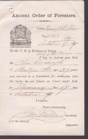
Document - ANCIENT ORDER OF FORESTERS NO. 3770 COLLECTION - CORRESPONDENCE
Printed paper dated Oct 19 1871 and signed by Jno Waller informing the Court that Thos Kavanagh of Bridge St was rejected as a Candidate for admission into the Order. Has Court seal of Court Queen of the Forest A.O.F. 3513 Sandhurst.societies, aof, correspondence, ancient order of foresters no. 3770 collection - correspondence, court queen of the forest, court king of the forest, thos kavanagh, jno waller -
 Bendigo Historical Society Inc.
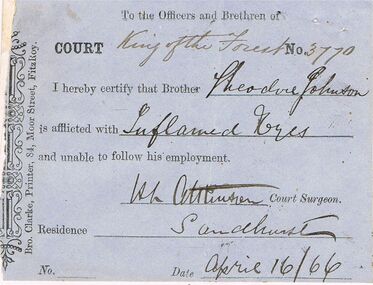
Document - ANCIENT ORDER OF FORESTERS NO 3770 COLLECTION: THEODORE JOHNSON
Blue slip signed by H. L. Atkinson, Court Surgeon, saying Theodore Johnson is unable to follow his employment and dated April 16/66. White note from Theodore Johnson claiming sick allowance, signed by Theodore Johnson, Long Gully and dated 16th April. A second white note from Theodore Johnson declaring himself off the sick fund, dated May the 2 1866. Signed by Theodore Johnson and H. L. Atkinson.Bro Clarke, Printer, 84 Moor St. Fitzroy, Theodore Johnson, H L Atkinsonsocieties, aof, correspondence, ancient order of foresters no 3770 collection - theodore johnson, court king of the forest, theodore johnson, h l atkinson, bro clarke -
 Bendigo Historical Society Inc.
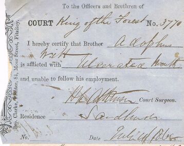
Document - ANCIENT ORDER OF FORESTERS NO 3770 COLLECTION: ADOLPHUS WITT
Blue slip signed by H. L. Atkinson, Court Surgeon, saying Adolphus Witt is unable to follow his employment and dated July 4/1865. White note from Adolphus Witt. Claiming sick allowance, signed by Adolphus Witt. Victoria Hill and dated July 4/1865. A second white note from Adolphus Witt declaring himself off the sick fund, dated July 15 1865. Signed by Adolphus Witt and H. L. Atkinson.Bro Clarke, Printer, 84 Moor St. Fitzroy, Adolphus Witt?, H L Atkinsonsocieties, aof, correspondence, ancient order of foresters no 3770 collection - adolphus witt, court king of the forest, adolphus witt, h l atkinson, bro clarke -
 Bendigo Historical Society Inc.
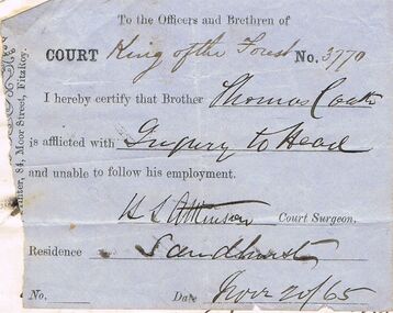
Document - ANCIENT ORDER OF FORESTERS NO 3770 COLLECTION: THOMAS COATH
Blue slip signed by H. L. Atkinson, Court Surgeon, saying Thomas Coath is unable to follow his employment and dated Nov 20/65. White note from Thomas Coath claiming sick allowance, signed by Thos Coath, Long Gully and dated November 20 65. A second white note from Thos Coath declaring himself off the sick fund, dated November 27th 1865. Signed by B. Wilcox and H. L. Atkinson.Bro Clarke, Printer 84 Moor St. Fitzroy, Thos Coath, H L Atkinsonsocieties, aof, correspondence, ancient order of foresters no 3770 collection - thomas coath, bro clarke, h l atkinson, court king of the forest -
 Bendigo Historical Society Inc.
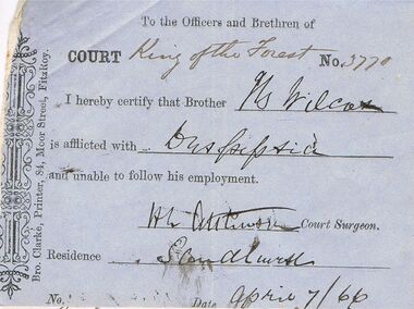
Document - ANCIENT ORDER OF FORESTERS NO 3770 COLLECTION: B. WILCOX
Blue slip signed by H. L. Atkinson, Court Surgeon, saying B Wilcox is unable to follow his employment and dated April 7/66. White note from B. Wilcox claiming sick allowance, signed by B. Wilcox, Derwent Gully and dated April 7th 1866. A second white note from B. Wilcox declaring himself off the sick fund, dated 26th april 1866. Signed by B. Wilcox and H. L. Atkinson.Bro. Clarke, Printer, 84 Moor St., Fitzroy, B Wilcox, H L Atkinsonsocieties, aof, correspondence, ancient order of foresters no 3770 collection - b wilcox, court king of the forest, b wilcox, h l atkinson, bro clarke -
 Bendigo Historical Society Inc.
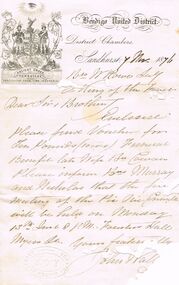
Document - ANCIENT ORDER OF FORESTERS NO. 3770 COLLECTION: CORRESPONDENCE
Letter from John Wal (the rest has been eaten by a silverfish) dated 7 Nov 1876. Letter mentions Voucher for £10 Funeral Benefit late Wife Bro Cowan. Also inform Bro Murray and Nicholas when the first meeting for the Pic Nic Committee will be held.societies, aof, correspondence, ancient order of foresters no. 3770 collection - correspondence, bendigo united district, court king of the forest, bro cowan, bro murray, bro nicholas, foresters hall myers st -
 Bendigo Historical Society Inc.
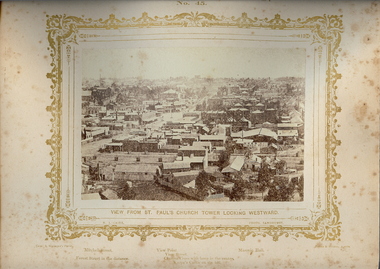
Photograph - VIEWS OF BENDIGO: LOOKING WEST FROM ST. PAUL'S CHURCH, 1875 copy,1970
Sepia photo on cream board. Shows westwards view over Bendigo from St. Pauls church tower. Inscription: Above image, 'Views of Bendigo|No.45.'. Below, 'View from St. Paul's church tower looking Westward.', 'N.J.Caire Photo, Sandhurst'. Bottom, 'Casey & Wenborn's Print Forbes & Holmes, Agents',' Mitchell Street, Forest Street in the distance',' View Point, View Street, Charing Cross with lamp in the centre. Knipe's Castle on the hill'. On Back, RHSV stamp, Bendigo Branch '1959|70' Nicholas CaireN.J.Caireplace, bendigo, view west from st.pauls church, see: 'views of bendigo' by n.j.caire -
 Bendigo Historical Society Inc.
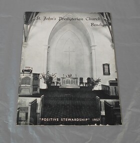
Booklet - Lydia Chancellor collection: St. John Presbyterian Church, Bendigo
... but the congregation outgrew it. In 1897 a new plot was purchased in Forest ...The original Presbyterian church was in Rowan Street but the congregation outgrew it. In 1897 a new plot was purchased in Forest Street and a new church designed by Vahland and son was designed and then built by Fairbanks and Wilson. It was of a gothic design with incandescent gasburners for lighting. It was designed to comfortably seat 400 people and was opened 4/7/1897.Eight pages booklet. The booklet is titled "St John's Presbyterian Church Bendigo, Positive stewardship, 1957". On the cover a black and white photograph of the inside of the church showing the apse. Omn the back the name of the Canvass Committee and the Stewardship Prayer. The first page of the booklet records a mesage from the minister J.W. Beecher.st. john presbyterian church, forest street, 1957 -
 Bendigo Historical Society Inc.
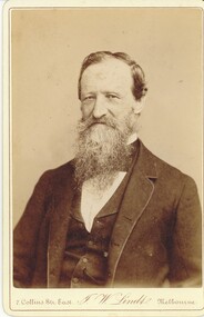
Photograph - HARRIS COLLECTION: MALE PHOTO, Nineteenth Century
Black & White studio portrait photograph. Bearded moustached male aged approx mid fifty. Head & Shoulders. Jacket & Vest. Printed on front. 7 Collins St East, J W Lindts Melbourne. Extensive Reverse Printing include. From J W Lindt's Studio above lithograph view of Melbourne. Special Publications. 'Album of Australian Aboriginals', Characteristic Australian Forest Scenery, Genre, Pictures of Bush Characters, Men of Mark and distinguished Visitors to Victoria. Gold, Silver & Bronze Medals and Diplomas. Awarded at Philadelphia, Paris, Sydney, Brisbane, Sandhurst.J W Lindt's Studiophotograph, person, male -
 Bendigo Historical Society Inc.
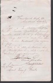
Document - ANCIENT ORDER OF FORESTERS NO. 3770 COLLECTION: CORRESPONDENCE
Note on white paper from Surgeon, James Eadie of Viewbend High St Sandhurst dated Sept 11 / 72 to The sec Court King of Forest certifying that G. ?outon declared himself on the sick Fund of Ct. Perservance on Aug 22nd 1872 and has been under treatment for an injury to his foot.societies, aof, correspondence, ancient order of foresters no. 3770 collection - correspondence, viewbend, g:outon, ct perseverance, james eadie, court king of the forest -
 Bendigo Historical Society Inc.
Document - ANCIENT ORDER OF FORESTERS NO. 3770 COLLECTION: CORRESPONDENCE
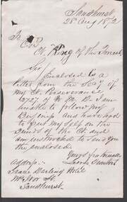
Letter from George ? Of the Grace Darling Hotel, McIvor St., Sandhurst dated 28 Aug 1872. He enclosed a letter from the Secy of Court Perseverance 2727. He has had to put himself on the funds of the Court and was instructed to send the enclosed.societies, aof, correspondence, ancient order of foresters no. 3770 collection - correspondence, court king of the forest, court perseverance 2727, george ?, grace darling hotel -
 Bendigo Historical Society Inc.
Document - ANCIENT ORDER OF FORESTERS NO. 3770 COLLECTION: CORRESPONDENCE
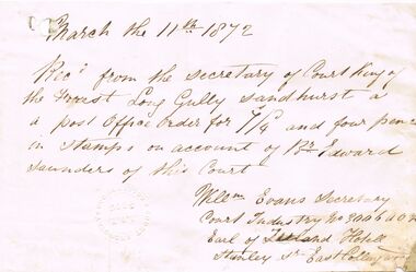
Receipt from Court Industry, East Collingwood, dated 11 March 1872, for P.O. Order for 7/4 and four pence in stamps on account of Br. Edward Saunders. Has Court Industry, Collingwood A.O.F. 3006 impression stamp. Court Industry address was the Earl of Zetland Hotel, Stanley St, East Collingwood.societies, aof, correspondence, ancient order of foresters no. 3770 collection - correspondence, court king of the forest, edward saunders, willm evans, earl of zetland hotel east collingwood -
 Bendigo Historical Society Inc.
Document - ANCIENT ORDER OF FORESTERS NO. 3770 COLLECTION: CORRESPONDENCE
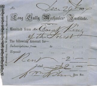
Blue printed receipt from Long Gully Mechanics' Institute for £2 received from Court King of the Forest for rent. Dated Decr 29 1877. Printed by J. Brockley, Printer, Williamson-st., Sandhurst.societies, aof, correspondence, ancient order of foresters no. 3770 collection - correspondence, long gully mechanics' institute, court king of the forest, j brockley -
 Bendigo Historical Society Inc.
Document - ANCIENT ORDER OF FORESTERS NO 3770 COLLECTION: DOCTOR'S CERTIFICATE
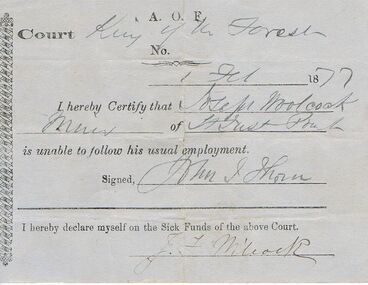
Blue Doctor's Certificate dated 1 Feb 1877 certifying that Joseph Woolcock Miner of St Just Point was unable to follow his usual employment and signed by H.L. Atkinson. Signed at the end by J Wilcock declaring himself of the Sick Funds. Name has been written as Joseph Woolcock, but when it was signed declaring himself of the Sick Funds it was signed J. Wilcock.societies, aof, correspondence, ancient order of foresters no 3770 collection - doctor's certificate, court king of the forest, joseph woolcock/wilcock, wm thorn? -
 Bendigo Historical Society Inc.
Document - ANCIENT ORDER OF FORESTERS NO. 3770 COLLECTION: MEDICAL CERTIFICATE
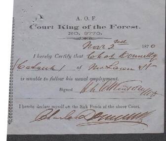
Blue paper dated Novr 2nd 1870. I hereby Certify that Chas. Donnelly of McLaren St. is unable to follow his usual employment. Signed H. L. Atkinson. Also signed at the end by Charles Donnelly declaring himself on the Sick Funds of the Court.societies, aof, correspondence, ancient order of foresters no. 3770 collection - medical certificate, court king of the forest, charles donnelly, h l atkinson -
 Bendigo Historical Society Inc.
Document - ANCIENT ORDER OF FORESTERS NO. 3770 COLLECTION: MEDICAL CERTIFICATE
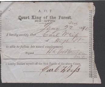
Blue paper dated Jany 22nd 1870. I hereby Certify that Carl Wrip of High St. Is able to follow his usual employment. Signed H. L. Atkinson. Also signed at the end by Carl Woefs declaring himslef off the Sick Funds of the Court.societies, aof, correspondence, ancient order of foresters no. 3770 collection - medical cetificate, court king of the forest, carl woefs, h l atkinson -
 Bendigo Historical Society Inc.
Document - ANCIENT ORDER OF FORESTERS NO. 3770 COLLECTION: MEDICAL CERTIFICATE
Blue paper dated Decr 29th 1870. I hereby Certify that C. W. Boegal of Honey Suckle St. Is able to follow his usual employment. Signed H. L. Atkinson. Also signed at the end by C. W. Boegal declaring himslef off the Sick Funds of the Court. Printed by J. Brockley, Printer, Bridge Street, Sandhurst.societies, aof, correspondence, ancient order of foresters no. 3770 collection - medical cetificate, court king of the forest, c w boegal, h l atkinson, j brockley -
 Bendigo Historical Society Inc.
Document - ANCIENT ORDER OF FORESTERS NO. 3770 COLLECTION: MEDICAL CERTIFICATE
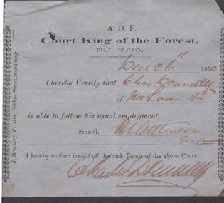
Blue paper dated Dec 26th 1870. I hereby Certify that Chas. Donnelly of McLaren St. is able to follow his usual employment. Signed H. L. Atkinson. Also signed at the end by Charles Donnelly declaring himself off the Sick Funds of the Court.societies, aof, correspondence, ancient order of foresters no. 3770 collection - medical cetificate, court king of the forest, richard maher, h l atkinson, j. brockley -
 Bendigo Historical Society Inc.
Document - ANCIENT ORDER OF FORESTERS NO. 3770 COLLECTION: MEDICAL CERTIFICATE
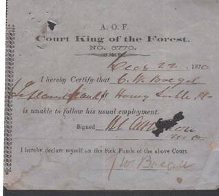
Blue paper dated Dec 22 1870. I hereby Certify that C. W. Boegel of Honey Suckle St. is unable to follow his usual employment. Signed H. L. Atkinson. Also signed at the end by C. W. Boegel declaring himself on the Sick Funds of the Court.societies, aof, correspondence, ancient order of foresters no. 3770 collection - medical cetificate, court king of the forest, c w boegel, h l atkinson -
 Bendigo Historical Society Inc.
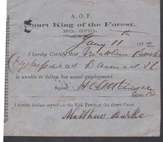
Document - ANCIENT ORDER OF FORESTERS NO. 3770 COLLECTION: MEDICAL CERTIFICATE
Blue paper dated Jan 11th 1872. I hereby Certify that Matthew Burke of Barnard St. is unable to follow his usual employment. Signed H. L. Atkinson. Also signed at the end by Matthew Burke declaring himself on the Sick Funds of the Court.societies, aof, correspondence, ancient order of foresters no. 3770 collection - medical cetificate, court king of the forest, matthew burke, h l atkinson -
 Bendigo Historical Society Inc.
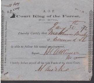
Document - ANCIENT ORDER OF FORESTERS NO. 3770 COLLECTION: MEDICAL CERTIFICATE
Blue paper dated Jan 30th 1872. I hereby Certify that Matthew Burke of Barnard St. is able to follow his usual employment. Signed H. L. Atkinson. Also signed at the end by M. Burke declaring himself off the Sick Funds of the Court. Printed by J. Brockley, Printer, Bridge Street, Sandhurst.societies, aof, correspondence, ancient order of foresters no. 3770 collection - medical cetificate, court king of the forest, matthew burke, h l atkinson, j brockley -
 Bendigo Historical Society Inc.
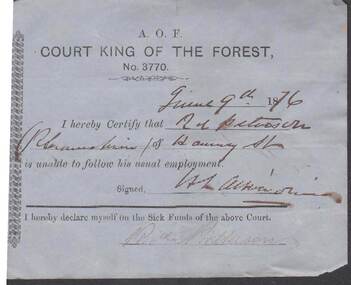
Document - ANCIENT ORDER OF FORESTERS NO 3770 COLLECTION: MEDICAL CERTIFICATE
Blue paper dated June 9th 1876. I hereby certify that Rd. Patterson of ? St. is unable to follow his usual employment. Signed by H. L. Atkinson. Signed at the end by Ricd. Patterson declaring himself on the Sick Funds of the Court.societies, aof, correspondence, ancient order of foresters no 3770 collection - medical certificate, court king of the forest, ricd patterson, h. l. atkinson -
 Bendigo Historical Society Inc.
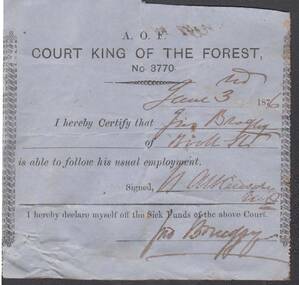
Document - ANCIENT ORDER OF FORESTERS NO 3770 COLLECTION: MEDICAL CERTIFICATE
Blue paper dated June 3rd 1876. I hereby certify that Jno Brogley of ? St. is able to follow his usual employment. Signed by H. L. Atkinson. Signed at the end by Jno Brog? Declaring himself off the Sick Funds of the Court.societies, aof, correspondence, ancient order of foresters no 3770 collection - medical certificate, court king of the forest, jno brogley, h. l. atkinson -
 Bendigo Historical Society Inc.
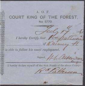
Document - ANCIENT ORDER OF FORESTERS NO 3770 COLLECTION: MEDICAL CERTIFICATE
Blue paper dated July 17th 1876. I hereby certify that Rd. Patterson of ? St. is able to follow his usual employment. Signed by H. L. Atkinson. Signed at the end by Rd. Patterson declaring himself off the Sick Funds of the Court.societies, aof, correspondence, ancient order of foresters no 3770 collection - medical certificate, court king of the forest, rd patterson, h l atkinson