Showing 3206 items matching " glenferrie road"
-
 Ballarat Tramway Museum
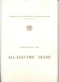
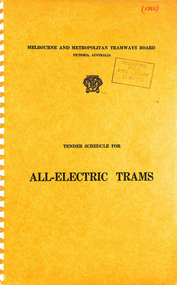
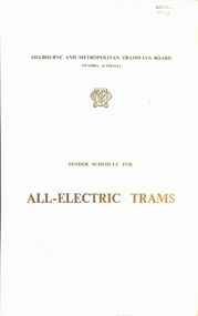
Document - Specification, Melbourne and Metropolitan Tramways Board (MMTB), "Tender Schedule for All-Electric Trams", 1972
... a map of the system, typical city route, Glenferrie Road route... a map of the system, typical city route, Glenferrie Road route ...Comb bound (white plastic) specification document, approx. 70 pages, with glossy card covers, titled "Tender Schedule for All-Electric Trams", published by the Melbourne and Metropolitan Tramways Board, closing 2 Oct. 1972. Details the conditions of tender, conditions of contract, notes, specification, gives background information about Melbourne, dimensions, performance, drivers and conductors, trucks, wheels, brakes, electrical equipment, control panels and drawings. The drawings give a map of the system, typical city route, Glenferrie Road route (grade diagram), concrete track construction, min. radius curves, loading gauge, all-electric tram and mounting details for the trolley base, schedule of prices, tender form, form of contract, schedule of information to be provided by the tenderer.trams, tramways, specification, tenders, z class trams, mmtb, melbourne -
 Kew Historical Society Inc
Photograph - 'Mount Eri', 9 Highbury Grove, 1919
... house for sale near the junction of Cotham and Glenferrie Roads... and Glenferrie Roads. The substantial red brick, slate-roofed house ...Subdivision plans are historically important documents used as evidence of the growth of suburbs in Australia. They frequently provide information about when the land was sold on which a built structure was subsequently constructed as well as evidence relating to surveyors and real estate and financial agents. The numerous subdivision plans in the Kew Historical Society's collection represent working documents, ranging from the initial sketches made in planning a subdivision to printed plans on which auctioneers or agents listed the prices for which individual lots were sold. In a number of cases, the reverse of a subdivision plan in the collection includes a photograph of a house that was also for sale by the agent. These photographs provide significant heritage information relating house design and decoration, fencing and household gardens.A photograph of Mount Eri, 9 Highbury Grove, an 11-room house for sale near the junction of Cotham and Glenferrie Roads. The substantial red brick, slate-roofed house and its location are not identified in the photograph, although the extent of the house is noted. It was described then as ‘well situated’ and close to 3 trams. Mathers, a financial agent in Cotham Road, placed advertisements about the sale of the property in The Argus in May and June 1919. The advertisement additionally refers to a billiard room and asserts that the house has every modern convenience. An annotation on the plan indicates that the house, with tennis court, was sold for £1960. Following extensive research, the house has now been conclusively identified, albeit extended and rendered. The house was originally built in the 19th century as a school and for much of the 20th century was used as a venue for receptions. -
 Melbourne Tram Museum
Pamphlet, Yarra Trams, "Toorak Road Tram Terminus Improvement Works", Nov. 2006
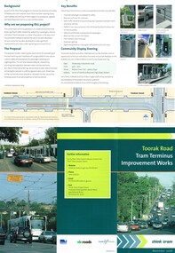
... titled "Toorak Road Tram Terminus Improvement Works", dated Nov..., along with the curve into Glenferrie Road. Gives details ...Pamphlet, folded to DL size, printed on full gloss paper titled "Toorak Road Tram Terminus Improvement Works", dated Nov. 2006 and part of the "Think Tram" project outlining the redevelopment proposals of the Toorak Road terminus. Shows the track plan and proposed stop, along with the curve into Glenferrie Road. Gives details of the proposal and consultative meetings. Gives details of the VicRoads think tram project contacts. Two copies held. The proposal did not proceed. Another proposal was prepared for Feb. 2015 and was not well received by the City of Stonington. See the local Leader dated 19/2/2015. Work to rebuild the tram stop planned by a Yarra Trams notice of 19-11-2015 to be undertake work at the intersection between 16-11-15 and 3-12-15.trams, tramways, yarra trams, toorak rd, route 8, superstops -
 Melbourne Tram Museum
Ephemera - Ticket/s, Melbourne & Metropolitan Tramways Board (MMTB), "Scholar's Yearly Concession Ticket", 1975 to 1977
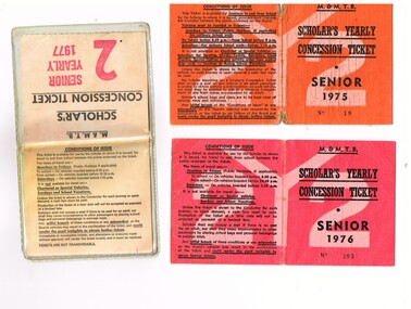
... and available from Cotham and Glenferrie Road, to Callantinia Road... and available from Cotham and Glenferrie Road, to Callantinia Road ...Set of two clothed backed paper tickets, printed as a MMTB "Scholar's Yearly Concession Ticket", for Seniors and one paper ticket contained within a plastic envelope. Gives condition of use on the outside cover. Each issue to Roderick Atkins. Each lists the various terms for which they were available and available from Cotham and Glenferrie Road, to Callantinia Road, Scotch College. Two sections. .1 - Orange cloth, Senior 1975, cost not shown No. 18 .2 - red cloth, Senior 1976, cost $39.00 No. 203 issued at Doncaster Depot .3 - light yellow paper within a plastic envelope, Senior 1976, cost $39, No. 42583, issued at Kew Depot. See Reg Item 5571 for other examples of item 3trams, tramways, mmtb, tickets, schools, schools tickets, scholar's tickets -
 Vision Australia
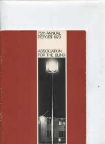
Administrative record - Text, 75th Annual Report 1970 Association for the Blind of Victoria, 1971
... at Mirridong next year, a second block of flats facing Glenferrie Road...Vision Australia 454 Glenferrie Road Kooyong melbourne ...Articles in annual report include: branch committees, President's report, finance report, balance sheet, hospital homes, blind citizens community centre, welfare, auxiliaries, senior staff, life governors, historical and current photographs of Ballarat, Bendigo, Brighton and the Blind Citizens Community centre, establishment of an ophthalmological clinic at Elanora, demand for more nursing beds and funding for nursing support, need for hostel accommodation for short stay or respite for carers, renaming of Brighton Blind Home to Elanora, 20 bed nursing wing to be opened at Mirridong next year, a second block of flats facing Glenferrie Road has been purchased due to demand for expansion at Kooyong Blind Citizens Community Centre, plan for a memorial garden with a sensory section in front of the club house, appointment of a hairdresser at Kooyong and two holidays at Cumberland House in Lorne have been organised and were a huge success1 volume of text and photographsassociation for the blind, elanora home (brighton), mirridong home (bendigo), kelaston home (ballarat), annual reports -
 Kew Historical Society Inc
Plan - Subdivision Plan, Wimba Estate, Kew, c.1925-c.1929, ca. 1925-ca. 1929
... in Cotham and Glenferrie Roads, and the Kew and Glenferrie Railway... Roads, and the Kew and Glenferrie Railway Stations. An oddity ...Pru Sanderson, in her groundbreaking ‘City of Kew Urban Conservation Study : Volume 2 - Development History’ (1988), summarised the periods of urban development and subdivisions of land in Kew. The periods that she identified included 1845-1880, 1880-1893, 1893-1921, 1921-1933, 1933-1943, and Post-War Development. These periods were selected as they represented periods of rapid growth or decline in urban development. An obvious starting point for Sanderson’s groupings involved population growth and the associated economic cycles. These cycles also highlighted urban expansion onto land that was predominantly rural, although in other cases it represented the decline and breakup of large estates. A number of the plans in the Kew Historical Society’s collection can also be found in other collections, such as those of the State Library of Victoria and the Boroondara Library Service. A number are however unique to the collection.Subdivision plans are historically important documents used as evidence of the growth of suburbs in Australia. They frequently provide information about when the land was sold on which a built structure was subsequently constructed as well as evidence relating to surveyors and real estate and financial agents. The numerous subdivision plans in the Kew Historical Society's collection represent working documents, ranging from the initial sketches made in planning a subdivision to printed plans on which auctioneers or agents listed the prices for which individual lots were sold. In a number of cases, the reverse of a subdivision plan in the collection includes a photograph of a house that was also for sale by the agent. These photographs provide significant heritage information relating house design and decoration, fencing and household gardens.In 1925, the City of Kew called for tenders for the construction of Wimba Avenue, Cadow Street and Lalla Street. Subsequent advertisements for the sale of land in Wimba Avenue continued from 1926 to 1929. The 18 lots (and a further five allotments on the eastern side of the street) offered for sale were unofficially described in the subdivision plan as the ‘Wimba Estate’. These lots began in Park Hill Road and extended almost to Cotham Road. The subdivision took its name from the house ‘Wimba’ in Cotham Road, which may have formed the southern boundary of the subdivision. (Wimba, at 235 Cotham Road was constructed between 1862-70). The Plan highlights the proximity and advantage of ‘electric’ trams in Cotham and Glenferrie Roads, and the Kew and Glenferrie Railway Stations. An oddity in the Plan is the reference to the electric tram terminus at Burke Road, given that the tramline had already been extended to Mont Albert in 1916.wimba estate, subdivision plans - kew, parkhill road – kew (vic.), normanby road – kew (vic.), wimba avenue – kew (vic.) -
 Kew Historical Society Inc
Functional object - Wrought iron nails from 'Reno', St John's Parade, c. 1864
... , Glenferrie Road, Wellington Street, and Charles Street. The southern..., Glenferrie Road, Wellington Street, and Charles Street. The southern ...Comparatively few weatherboard houses in Kew survived from the early years of settlement into the second half of the 20th century. One such property was ‘Reno’, which once stood on the east side of St John’s Parade. Its earliest recorded owner was the architect Samuel Cocking who lived there from c.1865 until his death in 1888. The original landholding was bordered by Cotham Road, Glenferrie Road, Wellington Street, and Charles Street. The southern portion of this land included a fine orchard, with many imported trees. The old summer house, at first in the orchard, was later removed to the house garden. The MMBW Detail Plan No.1576 (1904) shows the remaining portion of the original land holding, including a semi-circular pathway at the front, and garden features such as an aviary, a fountain and grotto, and a fernery. None of these are apparent in photographs dating from the 1960s, where the garden, which once included rare plants provided by Baron Von Mueller, surrounds the cottage in a tangled frenzy. Despite a ‘local significance’ classification by the National Trust, the house was demolished in 1977.7 square headed iron nails collected from Reno before its demolition. In envelope marked with the name Joy Stewartreno, nails, samuel cocking -
![Wallpaper from 'Reno', St John's Parade [Kew]](/media/collectors/550653872162f11fb04854aa/items/57975996d0cdd1098c81d980/item-media/579759ded0cdd1098c81f6fa/item-fit-380x285.jpg) Kew Historical Society Inc
Kew Historical Society IncDecorative object - Wallpaper sample from 'Reno', St John's Parade, 1890s
... , Glenferrie Road, Wellington Street, and Charles Street. The southern..., Glenferrie Road, Wellington Street, and Charles Street. The southern ...Comparatively few weatherboard houses in Kew survived from the early years of settlement into the second half of the 20th century. One such property was ‘Reno’, which once stood on the east side of St John’s Parade. Its earliest recorded owner was the architect Samuel Cocking who lived there from c.1865 until his death in 1888. The original landholding was bordered by Cotham Road, Glenferrie Road, Wellington Street, and Charles Street. The southern portion of this land included a fine orchard, with many imported trees. The old summer house, at first in the orchard, was later removed to the house garden. The MMBW Detail Plan No.1576 (1904) shows the remaining portion of the original land holding, including a semi-circular pathway at the front, and garden features such as an aviary, a fountain and grotto, and a fernery. None of these are apparent in photographs dating from the 1960s, where the garden, which once included rare plants provided by Baron Von Mueller, surrounds the cottage in a tangled frenzy. Despite a ‘local significance’ classification by the National Trust, the house was demolished in 1977. Wallpaper fragment from ‘Reno’. This small fragment of floral wall paper is a bolder design than the delicately drawn flowers in 1977.0005.1. The flowers in this example were impressionistically created using printing blocks that allowed for different thicknesses of paint to be applied in the hand-blocking process. wallpaper, reno, st john's parade, kew -
![Wallpaper from 'Reno', St John's Parade [Kew]](/media/collectors/550653872162f11fb04854aa/items/57975a62d0cdd1098c8232a8/item-media/57975cabd0cdd1098c836f91/item-fit-380x285.jpg) Kew Historical Society Inc
Kew Historical Society IncDecorative object - Wallpaper sample from 'Reno', St John's Parade, 1870s
... , Glenferrie Road, Wellington Street, and Charles Street. The southern..., Glenferrie Road, Wellington Street, and Charles Street. The southern ...Comparatively few weatherboard houses in Kew survived from the early years of settlement into the second half of the 20th century. One such property was ‘Reno’, which once stood on the east side of St John’s Parade. Its earliest recorded owner was the architect Samuel Cocking who lived there from c.1865 until his death in 1888. The original landholding was bordered by Cotham Road, Glenferrie Road, Wellington Street, and Charles Street. The southern portion of this land included a fine orchard, with many imported trees. The old summer house, at first in the orchard, was later removed to the house garden. The MMBW Detail Plan No.1576 (1904) shows the remaining portion of the original land holding, including a semi-circular pathway at the front, and garden features such as an aviary, a fountain and grotto, and a fernery. None of these are apparent in photographs dating from the 1960s, where the garden, which once included rare plants provided by Baron Von Mueller, surrounds the cottage in a tangled frenzy. Despite a ‘local significance’ classification by the National Trust, the house was demolished in 1977.Wallpaper fragment from ‘Reno’. This large single example is interesting as it represents a change in fashion and style from the finely drawn flowers (1971.0002.1) of an older paper, parts of which can be seen behind this sample. Typically the updating of wallpapers was accomplished by laying a new paper over the old. The ‘newer’ wallpaper is of a single colour, the tone of which may have suffered from colour distortion due to ageing. The new block-printed design, featuring repeated sprays of flowers and leaves combines a bold use of colour with an elegance of design.reno, st john's parade, kew, samuel cocking, wallpaper -
![Wallpaper fragment - Reno, St John's Parade [Kew]](/media/collectors/550653872162f11fb04854aa/items/57975cd6d0cdd1098c838ddb/item-media/57975d42d0cdd1098c83c222/item-fit-380x285.jpg) Kew Historical Society Inc
Kew Historical Society IncDecorative object - Wallpaper sample from 'Reno', St John's Parade, 1870s
... , Glenferrie Road, Wellington Street, and Charles Street. The southern..., Glenferrie Road, Wellington Street, and Charles Street. The southern ...Comparatively few weatherboard houses in Kew survived from the early years of settlement into the second half of the 20th century. One such property was ‘Reno’, which once stood on the east side of St John’s Parade. Its earliest recorded owner was the architect Samuel Cocking who lived there from c.1865 until his death in 1888. The original landholding was bordered by Cotham Road, Glenferrie Road, Wellington Street, and Charles Street. The southern portion of this land included a fine orchard, with many imported trees. The old summer house, at first in the orchard, was later removed to the house garden. The MMBW Detail Plan No.1576 (1904) shows the remaining portion of the original land holding, including a semi-circular pathway at the front, and garden features such as an aviary, a fountain and grotto, and a fernery. None of these are apparent in photographs dating from the 1960s, where the garden, which once included rare plants provided by Baron Von Mueller, surrounds the cottage in a tangled frenzy. Despite a ‘local significance’ classification by the National Trust, the house was demolished in 1977. Wallpaper fragment from ‘Reno’. These three boldly designed samples from a single room are in shades of green and brown, highlighted by yellow and red floral sprays. While more accurately printed and coloured, the fragment lacks the freedom of design of the earlier samples.wallpaper, reno, st john's parade, kew, samuel cocking -
![Reno, St John's Parade [Kew] - Reno, St John's Parade [Kew]](/media/collectors/550653872162f11fb04854aa/items/57975dcbd0cdd1098c840aaf/item-media/57975e31d0cdd1098c84343d/item-fit-380x285.jpg) Kew Historical Society Inc
Kew Historical Society IncDecorative object - Wallpaper samples from 'Reno', St John's Parade, 1880-1910
... , Glenferrie Road, Wellington Street, and Charles Street. The southern..., Glenferrie Road, Wellington Street, and Charles Street. The southern ...Comparatively few weatherboard houses in Kew survived from the early years of settlement into the second half of the 20th century. One such property was ‘Reno’, which once stood on the east side of St John’s Parade. Its earliest recorded owner was the architect Samuel Cocking who lived there from c.1865 until his death in 1888. The original landholding was bordered by Cotham Road, Glenferrie Road, Wellington Street, and Charles Street. The southern portion of this land included a fine orchard, with many imported trees. The old summer house, at first in the orchard, was later removed to the house garden. The MMBW Detail Plan No.1576 (1904) shows the remaining portion of the original land holding, including a semi-circular pathway at the front, and garden features such as an aviary, a fountain and grotto, and a fernery. None of these are apparent in photographs dating from the 1960s, where the garden, which once included rare plants provided by Baron Von Mueller, surrounds the cottage in a tangled frenzy. Despite a ‘local significance’ classification by the National Trust, the house was demolished in 1977.Wallpaper fragment from ‘Reno’. These two large fragments of wallpaper have a formality of design that is accentuated by the wide borders and narrow vertical lines that separate the repeated designs of rose garlands in vases on a vertical trellis design. The design is in tones of pink and green with gilding.reno, st john's parade, kew, samuel cocking, wallpaper -
![Wallpaper from 'Reno', St John's Parade [Kew]](/media/collectors/550653872162f11fb04854aa/items/57975eabd0cdd1098c846619/item-media/57975ee7d0cdd1098c8484f7/item-fit-380x285.jpg) Kew Historical Society Inc
Kew Historical Society IncDecorative object - Wallpaper samples from 'Reno', St John's Parade, 1880-1914
... , Glenferrie Road, Wellington Street, and Charles Street. The southern..., Glenferrie Road, Wellington Street, and Charles Street. The southern ...Comparatively few weatherboard houses in Kew survived from the early years of settlement into the second half of the 20th century. One such property was ‘Reno’, which once stood on the east side of St John’s Parade. Its earliest recorded owner was the architect Samuel Cocking who lived there from c.1865 until his death in 1888. The original landholding was bordered by Cotham Road, Glenferrie Road, Wellington Street, and Charles Street. The southern portion of this land included a fine orchard, with many imported trees. The old summer house, at first in the orchard, was later removed to the house garden. The MMBW Detail Plan No.1576 (1904) shows the remaining portion of the original land holding, including a semi-circular pathway at the front, and garden features such as an aviary, a fountain and grotto, and a fernery. None of these are apparent in photographs dating from the 1960s, where the garden, which once included rare plants provided by Baron Von Mueller, surrounds the cottage in a tangled frenzy. Despite a ‘local significance’ classification by the National Trust, the house was demolished in 1977. Wallpaper fragment from ‘Reno’. This small fragment is part of the larger design shown in the previous sample (1971.0002.5). It includes a detail of the trellis element from the larger scheme.wallpaper, samuel cocking, reno, st john's parade, kew -
![Letter Plate, 'Reno', St John's Parade [Kew]](/media/collectors/550653872162f11fb04854aa/items/57a03863d0cdd1210435bac1/item-media/57a038b1d0cdd1210435f155/item-fit-380x285.jpg) Kew Historical Society Inc
Kew Historical Society IncFunctional object - Letter Plate, 'Reno', St John's Parade, c.1900
... , Glenferrie Road, Wellington Street, and Charles Street. The southern..., Glenferrie Road, Wellington Street, and Charles Street. The southern ...Comparatively few weatherboard houses in Kew survived from the early years of settlement into the second half of the 20th century. One such property was ‘Reno’, which once stood on the east side of St John’s Parade. Its earliest recorded owner was the architect Samuel Cocking who lived there from c.1865 until his death in 1888. The original landholding was bordered by Cotham Road, Glenferrie Road, Wellington Street, and Charles Street. The southern portion of this land included a fine orchard, with many imported trees. The old summer house, at first in the orchard, was later removed to the house garden. The MMBW Detail Plan No.1576 (1904) shows the remaining portion of the original land holding, including a semi-circular pathway at the front, and garden features such as an aviary, a fountain and grotto, and a fernery. None of these are apparent in photographs dating from the 1960s, where the garden, which once included rare plants provided by Baron Von Mueller, surrounds the cottage in a tangled frenzy. Despite a ‘local significance’ classification by the National Trust, the house was demolished in 1977.Brass letter plate, originally from the front door of Reno in St John's Parade, Kew. Donated by Miss McDowell in 1977, in the year the house was demolished.reno, st john's parade, kew -
![Wallpaper sample from 'Reno', St John's Parade [Kew]](/media/collectors/550653872162f11fb04854aa/items/5670dfde2162f10b54fac48a/item-media/5797600bd0cdd1098c854c29/item-fit-380x285.jpg) Kew Historical Society Inc
Kew Historical Society IncDecorative object - Wallpaper sample from 'Reno', St John's Parade, 1850-1880
... , Glenferrie Road, Wellington Street, and Charles Street. The southern..., Glenferrie Road, Wellington Street, and Charles Street. The southern ...Comparatively few weatherboard houses in Kew survived from the early years of settlement into the second half of the 20th century. One such property was ‘Reno’, which once stood on the east side of St John’s Parade. Its earliest recorded owner was the architect Samuel Cocking who lived there from c.1865 until his death in 1888. The original landholding was bordered by Cotham Road, Glenferrie Road, Wellington Street, and Charles Street. The southern portion of this land included a fine orchard, with many imported trees. The old summer house, at first in the orchard, was later removed to the house garden. The MMBW Detail Plan No.1576 (1904) shows the remaining portion of the original land holding, including a semi-circular pathway at the front, and garden features such as an aviary, a fountain and grotto, and a fernery. None of these are apparent in photographs dating from the 1960s, where the garden, which once included rare plants provided by Baron Von Mueller, surrounds the cottage in a tangled frenzy. Despite a ‘local significance’ classification by the National Trust, the house was demolished in 1977.Original sample of nineteenth century wallpaper from one of the earliest homes in Kew (Victoria).Wallpaper fragment from ‘Reno’. These two samples of light brown Victorian-period wallpaper were overprinted with flowers and leaves that are outlined in maroon. Flowers and foliage are painted in blue of varying intensity, giving the impression of being hand painted. The style of this wallpaper would have been suited to a bedroom or drawing room.wallpaper, samuel cocking, reno, st john's parade, kew -
 Vision Australia
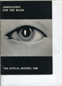
Administrative record - Text, 73rd Annual Report 1968 Association for the Blind of Victoria, 1969
... of flats facing Glenferrie Road, with the assistance of the William...Vision Australia 454 Glenferrie Road Kooyong melbourne ...Articles in annual report include: branch committees, President's report, finance report, balance sheet, hospital homes, community centre, welfare, volunteer service group, auxiliaries, life governors, guiding light appeal, Isadore Smith's bravery, Prime Minister Hon. J.G. Gorton opening the Ballarat section of the Guiding Light Appeal, Victorian Governor General Sir Rohan Delacombe the Bendigo section and Victorian Premier Sir Henry Bolte the Metropolitan section, Hubert Opperman being knighted in the Queen's Birthday honours, waiting list time for admission is 18 months - two years and are almost exclusively nursing cases as the peak for active aged recedes, erection of the two storey wing at Brighton thanks to grant from estate of the late Herbert Engelbert, the demolishing of the 100 year house at Brighton required for the extension, Mrs Laura Clarke - a resident of Mirridong - celebrated turning 102, and the need for additional room and accommodation for a resident caretaker has necessitated the purchase of a block of flats facing Glenferrie Road, with the assistance of the William Buckland Trust.16 pages of text and photographsassociation for the blind, isadore smith, e.a. soderstrom, miss tobias, annual reports -
![Uniform - School Uniform, Woodbury Ladies’ College [Kew] Badge, circa 1918, c.1918](/media/collectors/550653872162f11fb04854aa/items/5e89f58a21ea671a7c03d0c9/item-media/5e89f65821ea671a7c0508fc/item-fit-380x285.jpg) Kew Historical Society Inc
Kew Historical Society IncUniform - School Uniform, Woodbury Ladies’ College [Kew] Badge, circa 1918, c.1918
... School in Kew. Woodbury College was founded in Glenferrie Road... in Kew. Woodbury College was founded in Glenferrie Road by a Miss ...Woodbury College was an indirect predecessor of Preshil School in Kew. Woodbury College was founded in Glenferrie Road by a Miss Harcourt, former principal of Sydenham College, Moonee Ponds. Miss Harcourt maintained the school until the goodwill was purchased in 1908 by Miss LJ Macey, who had previously operated Lillsden Ladies' College in Edgevale Road, between c.1891 and c.1903. The first school was in a rented building on the south side of Cotham Road between Atkins and Davis Streets. In 1910, a new school building was built on the corner of Uvadale Grove and Cotham Road [the building is still extant as of 2020]. Woodbury College was operated by Miss LJ and Miss HJ Macey until 1920. In 1921, the school amalgamated with the newly formed St Andrew's College, Mont Victor Road, Kew (Vic) under the leadership of Rev JT Lawton [who had previously been principal of St Andrew's School of the 'Pathfinder' in South Yarra]. Miss Macey was for a period the Headmistress of the amalgamated school. Another teacher at the school was Miss Margaret JR Lyttle, who in 1931, left St Andrew's to form the Preshil School.Rare ephemera relating to an early private school in Kew (Vic). The badge was donated by Helen Lade.Brass school badge which includes the initials WL within a large C, surrounded with the school crest - VERITAS VINCIT [Truth Prevails] of Woodbury Ladies College (1903-1920). woodbury college, schools - cotham road - kew - vic, private schools - kew (vic) -
 Kew Historical Society Inc
Archive (series) - Subject File, Kew Historical Society, Woodbury Ladies' College, 1986
... in Glenferrie Road by a Miss Harcourt, former principal of Sydenham... in Kew. Woodbury College was founded in c.1898 in Glenferrie Road ...Various partiesReference, Research, InformationSecondary Values (KHS Imposed Order)Subject file containing information about Woodbury College, Cotham Road, Kew (Vic). The file includes historically significant primary sources relating to the former Woodbury College [c.1898-1920] and Lillsden Ladies' College, Edgevale Road, Kew (Vic) [c.1891-1903]. In addition to manuscripts, the file also includes photographs and ephemera such as a metal school badge, a hatband and printed programs and school magazines. The file [as of 2020] includes materials donated between 1986 and 2005 by descendants of the second principal (Miss Macey), and by former students and or their descendants. The contents of the reference file include: 1. School origins : undated handwritten manuscript [2pp]; 2. Annual Reports : Handwritten manuscripts for the years 1908, 1909, 1910, 1912, 1913, 1914, 1916, 1917, 1919, 1920 by Miss LJ Macey; 3. Prize List : undated manuscript [3pp]; 4. School Magazine ; undated handwritten manuscripts about the origin of the school's magazine; 5. Woodbury Chat [school magazine] : printed booklets from the years 1918, 1919, 1920 x 2; 6. Correspondence [sundry] : handwritten letters from a parent [1916] and a former pupil (sic) [1938] to Miss Macey; 7. Exercise Books : one containing a handwritten history of the school(s) and the names and addresses of former students and teachers; and the other containing information relating to the National Home Reading Union, Kew Circle [1912-c.1916]. 8. Metal school badge and photographic negative of students. The names of various donors are listed in the file: they include Ann Ransom, Muriel Coghlan, Helen Lade, and Lilian McRae (nee Houston).woodbury college, misses macey, schools - kew (vic), schools - cotham road - kew - vic, private schools - kew (vic), rev jt lawton, cotham road - kew (vic.)woodbury college, misses macey, schools - kew (vic), schools - cotham road - kew - vic, private schools - kew (vic), rev jt lawton, cotham road - kew (vic.) -
![Uniform - School Uniform, Hatband of Woodbury Ladies’ College [Kew], circa 1918, c.1918](/media/collectors/550653872162f11fb04854aa/items/5e254add21ea671e18757914/item-media/5e254b2121ea671e1875b9aa/item-fit-380x285.jpg) Kew Historical Society Inc
Kew Historical Society IncUniform - School Uniform, Hatband of Woodbury Ladies’ College [Kew], circa 1918, c.1918
... School in Kew. Woodbury College was founded in Glenferrie Road... in Kew. Woodbury College was founded in Glenferrie Road by a Miss ...Woodbury College was an indirect predecessor of Preshil School in Kew. Woodbury College was founded in Glenferrie Road by a Miss Harcourt, former principal of Sydenham College, Moonee Ponds. Miss Harcourt maintained the school until the goodwill was purchased in 1908 by Miss LJ Macey, who had previously operated Lillsden Ladies' College in Edgevale Road, between c.1891 and c.1903. The first school was in a rented building on the south side of Cotham Road between Atkins and Davis Streets. In 1910, a new school building was built on the corner of Uvadale Grove and Cotham Road [the building is still extant as of 2020]. Woodbury College was operated by Miss LJ and Miss HJ Macey until 1920. In 1921, the school amalgamated with the newly formed St Andrew's College, Mont Victor Road, Kew (Vic) under the leadership of Rev JT Lawton [who had previously been principal of St Andrew's School of the 'Pathfinder' in South Yarra]. Miss Macey was for a period the Headmistress of the amalgamated school. Another teacher at the school was Miss Margaret JR Lyttle, who in 1931, left St Andrew's to form the Preshil School.Rare ephemera relating to an early private school in Kew (Vic). The hatband was worn by Lilian McCrae in circa 1918 and donated by her sister Heather Houston. The badge was donated by Helen Lade.Navy blue hatband with narrow white and yellow stripes of Woodbury Ladies College (1903-1920). woodbury college, schools - cotham road - kew - vic, private schools - kew (vic) -
 Kew Historical Society Inc
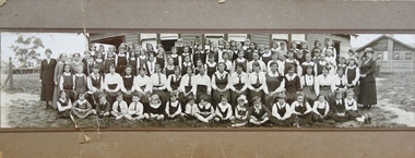
Photograph - Woodbury Ladies’ College, 1919
... School in Kew. Woodbury College was founded in Glenferrie Road... in Kew. Woodbury College was founded in Glenferrie Road by a Miss ...Woodbury College is an indirect predecessor of Preshil School in Kew. Woodbury College was founded in Glenferrie Road by a Miss Harcourt, former principal of Sydenham College, Moonee Ponds. Miss Harcourt maintained the school until the goodwill was purchased in 1908 by Miss LJ Macey, who had previously operated Lillsden Ladies' College in Edgevale Road, between c.1891 and c.1903. The first school was in a rented building on the south side of Cotham Road between Atkins and Davis Streets. In 1910, a new school building was built on the corner of Uvadale Grove and Cotham Road [the building is still extant as of 2020]. Woodbury College was operated by Miss LJ and Miss HJ Macey until 1920. In 1921, the school amalgamated with the newly formed St Andrew's College, Mont Victor Road, Kew (Vic) under the leadership of Rev JT Lawton [who had previously been principal of St Andrew's School of the 'Pathfinder' in South Yarra]. Miss Macey was for a period the Headmistress of the amalgamated school. Another teacher at the school was Miss Margaret JR Lyttle, who in 1931, left St Andrew's to form the Preshil School.A rare panoramic photograph of Woodbury College in Kew, Victoria. The photograph is part of a large collection of original manuscripts and ephemera relating to the school.Panoramic photograph of the students and teachers of Woodbury College, Cotham Road (Kew). Students identified in the photograph include: Back Row, 5th from left Betty Paton; 4th from right - Jean Strickey (sic).Annotation to reverse: "Woodbury College (Miss L.J. Massey) established Cotham Rd Kew. Est. at this venue 1908. Later joined by Rev. J.T. Lawton & formed a school in Mount Victor Rd Kew St Andrew’s College in 1921.’ woodbury college, cotham road (kew), education, schools, kew, l.j. massey, j.t. lawton, st andrew's college -
 Melbourne Tram Museum
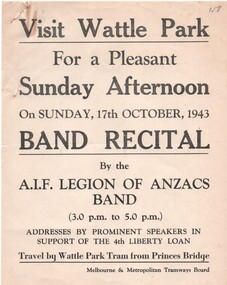
Document - Notice, Report, Melbourne & Metropolitan Tramways Board (MMTB), "Wattle Park Band Recital", Oct. 1943
... of timing and loading on trams at Glenferrie Road. Signed R... at Glenferrie Road. Signed R. Whitelaw. .6 - ditto for loading ex ...Set of six documents associated with a Wattle Park band recital by the AIF Legion of Anzacs band on Sunday 17 October 1943 in support of the 4th Liberty Loan. .1 - printed poster advertising the afternoon and travel by tram from Princes Bridge. .2 - duplicated notice from the Assistant Manager to Depots dated 13/10/1943 about the bus to be used to transport band members from Elizabeth St to Wattle Park - Central Bus Depot - notes the bus had been specially prepared for the event. .3 - typed notice from the District Traffic Superintendent to Hawthorn and Camberwell depots about special trams for the event and arrangements for conductors. Signed by J. M. Harry rubber stamp. .4 - hand written in blue indelible pencil on ruled paper, the table for the special cars for the event. .5 - hand written notes on heavy card of timing and loading on trams at Glenferrie Road. Signed R. Whitelaw. .6 - ditto for loading ex Wattle Park loop - signed by A? Cameron.1 - has a pencil inscription "158" in the top left hand corner. .3 - has a pencil note "Copy sent Hawt Insp with table" along the bottom edge.trams, tramways, mmtb, world war 2, wattle park, events, bands, buses, hawthorn depot, camberwell depot -
 Melbourne Tram Museum
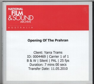
Film - Compact Diskette with video, National Film & Sound Archive Australia, "Opening of the Prahran", May. 2010
... of the depot, 12 in Glenferrie Road, lots of people views, horse drawn... of the depot, 12 in Glenferrie Road, lots of people views, horse drawn ...Compact Diskette with video (DVD), titled "Opening of the Prahran" - in a black plastic case with a black back and insert of the National Film & Sound Archive Australia, titled "Opening of the Prahran". Gives information on the client, length and date of transfer. Video from film by Johnson and Gibson, titled the "Opening Prahran and Malvern Tramway " features people speaking from a spiral staircase, trams No. 1, 2 and 3 running out of the depot, 12 in Glenferrie Road, lots of people views, horse drawn bus 6 with Mayor, 6 with Mayor getting off, single track, driver. Second film with countdown strip as for above. Same as chapter 3 of Reg item 925. Has copyright restrictions. .2 - three A4 sheets, stapled in the top left hand corner and folded into 8. Located within the CD folder. Gives details of the National Film & Sound Archive Australia, Usage agreement, contact names, approved use, fees, acceptance by Colin Tyrus of Yarra trams and a schedule of materials.trams, tramways, pmtt, opening, yarra trams, malvern depot, centenaries, films -
 Melbourne Tram Museum
Document - Tender Document, Melbourne & Metropolitan Tramways Board (MMTB), "Design, Manufacture and delivery of 100 only all-electric trams", Aug. 1966
... a map of the system, typical city route, Glenferrie Road route... of the system, typical city route, Glenferrie Road route (grade diagram ...Comb bound (white plastic) specification or tender document, approx. 70 pages, with glossy card covers, titled "Tender Schedule for All-Electric Trams", published by the Melbourne and Metropolitan Tramways Board, closing 12 September 1966. Details the conditions of tender, conditions of contract, notes, specification, gives background information about Melbourne, dimensions, performance, drivers and conductors, trucks, wheels, brakes, electrical equipment, control panels and drawings. The drawings give a map of the system, typical city route, Glenferrie Road route (grade diagram), concrete track construction, min. radius curves, loading gauge, all-electric tram and mounting details for the trolley base, schedule of prices, tender form, form of contract, schedule of information to be provided by the tenderer. Second copy from same donor added 9-3-2017 See Reg Item 2266 for the 1972 version and 4667 for a draft version - dated June 1965. See Item 4388 for the Z3 document. See Reg Item 4049 for associated newspaper cuttings.In red felt pen on top right hand corner "(1966)". Has stamp "Discarded from PTC Library 22 Oct. 1989" on front cover. 2nd copy has "1966" in ink in top right hand corner.trams, tramways, specification, tenders, z class, mmtb, melbourne -
 Melbourne Tram Museum
Document - Specification, Melbourne & Metropolitan Tramways Board (MMTB), "Design, Manufacture and delivery of 100 only all-electric trams", Jun. 1965
... a map of the system, typical city route, Glenferrie Road route... of trolley wire 9 - P.13855 - Glenferrie Road, Longitudinal Section ...Specification or Tender Document - titled "Design, Manufacture and delivery of 100 only all-electric trams", and "Background Information and Preliminary Specification", dated June 1965. Bound into a brown foolscap card cover. Details the conditions of tender, conditions of contract, notes, specification, gives background information about Melbourne, dimensions, performance, drivers and conductors, trucks, wheels, brakes, electrical equipment, control panels and drawings. The drawings give a map of the system, typical city route, Glenferrie Road route (grade diagram), concrete track construction, min. radius curves, loading gauge, all-electric tram and mounting details for the trolley base, schedule of prices, tender form, form of contract, schedule of information to be provided by the tenderer. Comprises: 1 - Conditions of Tendering - 1 page 2 - Conditions of Contract - 4 pages 3 - Contents - 3 pages 4 - Notes for prospective tenderers - dated June 1965 5 - General nature of contract - 21 pages 6 - Appendix A - climate data - two sheets 7 - List of 14 appended drawings 8 - O.6887A - cross section of trolley wire 9 - P.13855 - Glenferrie Road, Longitudinal Section 10 - P.13856 - Wattle Park Route 11 - P.13857 - East Preston Route 12 - P13858 - Concrete track construction 13 - P13859 - Open track construction 14 - P.13860 - Paved ballast track construction 15 - P.13887 - Tram Route - locations of substations and section switches 16 - P.13888 - Minimum radius service curves to give minimum clearance between tramcars 17 - P.13889 - Grooved Rail - 102 pounds per yard and tire profile 18 - R10-301 - Loading gauge, proposed electric tramcars 19 - R9706K - Rolling stock data, tramcars 20 - R10306 - Collins Points Shifter - Wiring diagram. 21 - Schedule of data to be supplied by the tenderer 22 - notes on Automatic Points shifters - 2 sheets 23 - Tender prices and delivery periods - 2 sheets. See Reg Item 2266 for the 1972 version and 1583 for the August 1966 version. See Reg Item 4049 for associated newspaper cuttings. See file htd4667i1.pdf for scans of the drawings.In ink in top right hand corner - "Lees"trams, tramways, specification, tenders, z class, mmtb, melbourne -
 Melbourne Tram Museum
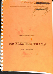
Document - Tender Document, Melbourne & Metropolitan Tramways Board (MMTB), "Tender Schedule for 100 Electric Trams Contract No. 3000", Apr. 1977
... . The drawings give a map of the system, typical city route, Glenferrie.... The drawings give a map of the system, typical city route, Glenferrie ...Comb bound (white plastic) specification or tender document, approx. 180 pages, with glossy card orange covers, titled "Tender Schedule for Electric Trams" and "Contract 3000". Compiled and published by the Melbourne and Metropolitan Tramways Board, closing Monday 10 May 1977. Details the conditions of tender, conditions of contract, notes, specification, gives background information about Melbourne, dimensions, performance, drivers and conductors, trucks, wheels, brakes, electrical equipment, control panels and drawings. The drawings give a map of the system, typical city route, Glenferrie Road route (grade diagram), concrete track construction, min. radius curves, loading gauge, all-electric tram and mounting details for the trolley base, schedule of prices, tender form, form of contract, schedule of information to be provided by the tenderer. Includes an Alphabetical Index. Includes a drawing for a single ended version of the tramcar. Became the Z3 class. Only the table of contents and the drawings scanned. See Reg Items 1583 and 2266 for other similar documents. See Reg Items 337 and 338 for a report on the operation of single ended tramcars 2 copies held.Has in ink written on front cover "J Armstrong" with a stamp blacked out and other copy of the same signature.trams, tramways, z3 class, specification, tenders, mmtb, melbourne, single ended tramcars -
 Melbourne Tram Museum
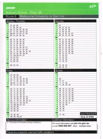
Ephemera - Timetable, Yarra Trams, Set of 12 laminated tram stop timetables, 2012, 2014
... /2014 .11 - Route 72, stop 72, Glenferrie Road - 31/3/2014 .12..., stop 72, Glenferrie Road - 31/3/2014 .12 - Route 72, stop 70 ...Set of 12 laminated tram stop timetables for various routes and stops. Has customer information line number, PTV and Yarra Tram logos. .1 - Route 6, stop 39 - Auburn Grove - 12/4/2012 .2 - Route 6, stop 36, Park Road - 28/3/2014 .3 - Route 16, stop 59, Malvern Road, 28/3/14 .4 - Route 8, stop 30, South Yarra Station - 28/3/2014 .5 - Route 55, Domain Interchange, stop 20 - 28/3/2014 .6 - Route 72, Prahran market - stop 30, - 31/3/2014 .7 - Route 72, Mathoura Road - stop 35 - 13/1/2014 .8 - Route 72, stop 33, Francis St - 31/3/2014 .9 - Route 72, stop 37, Orrong Road - 31/3/2014 .10 - Route 72, stop 38, Clendon Road - 31/1/2014 .11 - Route 72, stop 72, Glenferrie Road - 31/3/2014 .12 - Route 72, stop 70, Cotham Road - 13/1/2014.trams, tramways, yarra trams, timetables, tram stops, route 6, route 16, route 8, route 55, route 72 -
 Melbourne Tram Museum
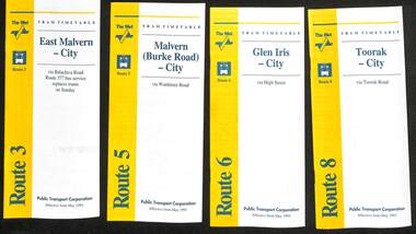
Ephemera - Timetable - The Met - set of 16, The Met, 1993
... (Cotham Rd) - St Kilda Beach via Glenferrie Road 14 - Route 70...) - St Kilda Beach via Glenferrie Road 14 - Route 70 - Wattle ...SSet of 16 The Met timetables, diagrammatic map, major stops and contact details. All dated May 1993 unless noted otherwise. 1 - Route 3 - East Malvern - City with a note that route 377 bus service replaces trams on Sunday. 2 - Route 5 - Malvern (Burke Rd) - City 3 - Route 6 - Glen Iris - City 4 - Route 8 - Toorak - City 5 - Route 10 - Sth Melbourne Beach and St Kilda Beach - West Preston 6 - Route 19 - North Coburg - City with a note that route 319 bus service to Gowrie and Upfield was included - ran Saturday afternoons and Sundays only. 7 - Route 42 - Mont Albert - City 8 - Route 48 - North Balwyn - City 9 - Route 55 - West Coburg - Domain Road interchange - with a note that route 68 operates via Elizabeth St on Sunday. 10 - Route 57- West Maribyrnong - City - with a note that route 357 bus services replaces trams on Sunday 11 - Route 59 - Airport West - City 12 - Route 64 - East Brighton - City 13 - Route 69 - Kew (Cotham Rd) - St Kilda Beach via Glenferrie Road 14 - Route 70 - Wattle Park - Princes Bridge 15 - Route 72 - Camberwell - City 16 - Route 82 - Moonee Ponds - Footscray and that route 223 bus replaces trams on Saturday afternoons and all day Sunday,Yields information about some of The Met tram services May 1993Set of 16 The Met timetables, DL size, printed in two colours.timetables, the met, route 8, route 3, route 5, route 6, route 10, route 19, route 42, route 48, route 55, route 57, route 59, route 64, route 69, route 70, route 72, route 82 -
 Vision Australia
Painting - Artwork, Portrait of John Wicking, 1980
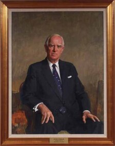
... in acquiring an adjacent property to those already owned in Glenferrie... in acquiring an adjacent property to those already owned in Glenferrie ...Framed portrait of John Wicking who was President of the Association for the Blind 1973-1984 as well as a generous benefactor. It is part of a series of paintings commissioned by the AFB Board to commemorate the work of past presidents of the organisation. Mr. Wicking wears a navy suit, white shirt and navy blue Kiwi tie. He was Managing Director and Chairman of Kiwi International when he was introduced to the Committee in 1971. With a natural air of authority, he was known to be both strong and wise. One of the first hurdles Mr Wicking faced following his election as President in 1973 was understanding the health service system and sorting out the differing views of committee members over recommendations for projects costing hundreds of thousands of dollars with no funds to implement them. The ten years of his Presidency were a time of exceptional growth and expansion. He was instrumental in acquiring an adjacent property to those already owned in Glenferrie Road in 1974 at a cost of $120,000, on which the Low Vision Clinic was erected – the first of its type in Australia. Land was also bought in both the metropolitan and country areas for future expansion. Day care centres were opened in Ballarat and Bendigo and new metropolitan services commenced. Mr Wicking formed a committee to explore the possibility of a radio station people unable to read standard print. As a result 3RPH commenced broadcasting in 1981. After his retirement as President, Mr. Wicking continued as a committee member until 1994. In 1995 he was instrumental in the establishment of the Tilly Aston Heritage Collection, on which he served as Chairman until sadly passing away in 2002. 1 art original in old gold frameThe plaque at the base of the painting reads 'Mr John O. Wicking AM / President 1973-1984 / Association for the Blind'. association for the blind, john wicking -
 Vision Australia
Award - Object, Wicker cricket ball, 1928
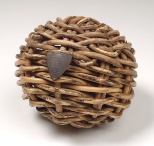
... and clubhouse in Glenferrie Road Kooyong, Victoria on behalf...Vision Australia 454 Glenferrie Road Kooyong melbourne ...This cricket ball is made of cane wicker and was used in cricket games with visually impaired players by people who lived or were educated at the Royal Victorian Institute for the Blind from the 1920's through till 1972. It is a circular shape made of plaited strips of woven natural cane and is lighter than a conventional cricket ball. The hollow center of the ball contains pieces of twisted metal pieces which rattle as the ball is moved to aid players in tracking the ball's movement. The stumps also had bells attached so fielders knew when the batsman was out. Blind cricket was invented in Melbourne in 1922 when two blind factory workers started playing a game using a tin can containing rocks. The game soon gained popularity and the Victorian Blind Cricketers' Association was formed. Mr William Paterson, a volunteer worker and advocate for blind people for over 60 years, was instrumental in acquiring and developing the sports ground and clubhouse in Glenferrie Road Kooyong, Victoria on behalf of the Association for the Advancement of the Blind (now called Vision Australia). In 1928 play began on the world's first sports ground for blind cricketers, in the first official blind cricket match. Blind cricket is now played internationally. This particular cricket ball was awarded to William Paterson Esq in 1928 in recognition of his support in establishing the world's first blind cricket ground in Kooyong. On the front of this ball is attached a small metal crest with an inscription: 'Presented to W.H. Paterson, Esq as a token of esteem for his interest in Blind cricket being the first ball bowled on the cricket ground for Blind Kooyong 7. 4.28'.1 wicker cricket ball with metal shield attached and metal bells in the hollow centre'Presented to W.H. Paterson, Esq / as a token of esteem for his/ interest in Blind cricket/ being the first ball bowled /on the cricket /ground for Blind /Kooyong / 7. 4.28'. recreation equipment, awards -
 Melbourne Tram Museum
Document - Tender Document, Melbourne & Metropolitan Tramways Board (MMTB), "Tender Schedule for All-Electric Trams - Contract 2500", Jul. 1972
... . The drawings give a map of the system, typical city route, Glenferrie... a map of the system, typical city route, Glenferrie Road route ...Comb bound (white plastic) specification or tender document, approx. 70 pages, with glossy card covers, titled "Tender Schedule for All-Electric Trams" and "Contract 2500", published by the Melbourne and Metropolitan Tramways Board, closing Monday 2 October 1972. Details the conditions of tender, conditions of contract, notes, specification, gives background information about Melbourne, dimensions, performance, drivers and conductors, trucks, wheels, brakes, electrical equipment, control panels and drawings. The drawings give a map of the system, typical city route, Glenferrie Road route (grade diagram), concrete track construction, min. radius curves, loading gauge, all-electric tram and mounting details for the trolley base, schedule of prices, tender form, form of contract, schedule of information to be provided by the tenderer. On the inside of the cover is a memo from D. Snell, Deputy Chairman to the Testing Engineer, dated 11/7/1972 about the tender being issued, but requesting least publicity and all enquiries to Mr. Snell. Part of the work to tender for the construction of Z class trams. Document scanned to pdf file word searchable. See Item 4388 for the Z3 document and 1583 for an August 1966 version and Reg item 4667 for a draft June 1965 version. 2nd copy added 7/8/2020 from Keith Kings papers.In in pencil in the top right hand corner of cover "1975" crossed out and "1972" written in. On first sheet in pencil, "Howard Smith" and "Laboratory 10 Feb 1975" stamped on.trams, tramways, specification, tenders, z class, mmtb, melbourne -
 Melbourne Tram Museum
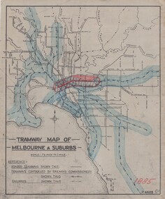
Drawing, H. S McComb, "Tramway Map of Melbourne & Suburbs", mid 1930's
... Road .11 - 1913 - Glenferrie Road, Cotham Road, Balaclava... - Glenferrie Road, Cotham Road, Balaclava and Glenhuntly Road .12 ...Set of 19 drawings showing the development of the Melbourne tramway system between 1885 and 1921. Based on MMTB drawing "Tramway Map of Melbourne & Suburbs" P4609, 18 sheets showing year by year development of the cable and electric tram system, printed on off white paper. Mr. McComb had intended it would appear to do further work - with some 20 sheets printed on brown card paper but not used (.19 - same drawing) Each sheet has the year in red at the bottom right hand corner of the sheet. .1 - 1885 - with the Richmond line and main rail lines coloured in showing a catchment area. .2 - 1886 - shows the new cable line in Collins St and has a note that no suburban line constructed in 1886 .3 - 1887 - Bourke and northern lines and Brighton Beach to Sandringham and Hawthorn to Kew .4 - 1888 - Swanston St, Domain Road, Chapel and inner circle and towards Hurstbridge.\ .5 - 1889 - Rathdown St and Toorak Road .6 - 1890 - South and Port Melbourne, North Melbourne and Northcote. Rail lines - Ashburton and parts of the outer circle to Oakleigh. .7 - 1891 - St Kilda Esplanade and northern section of the outer circle. .8 - 1906 - NMETL .9 - 1910 - PMTT - High St and Wattletree Road .10 - 1911 - PMTT Dandenong Road .11 - 1913 - Glenferrie Road, Cotham Road, Balaclava and Glenhuntly Road .12 - 1914 - small extension in High St .13 - 1915 - Malvern Road and High St Kew .14 - 1916 - HTT and MBCTT lines and Whitehorse Road .15 - 1917 - Burke Road .16 - 1918 - Burke Road north of Camberwell station .17 - 1920 - FNPTT - St Georges Road and Plenty Road .18 - 1921 - Footscray lines .19 - base drawing only. Does not show the VR tramlines. See Reg Item 2154 for associated notes.See individual sheets.trams, tramways, times, cable trams, railways, tramways, melbourne, maps