Showing 206 items
matching lands office
-
 Bendigo Historical Society Inc.
Document - KELLY AND ALLSOP COLLECTION: VICTORIA LAND TAX ACT 1910 - FORM, 31/12/1910 to 01/03/1911
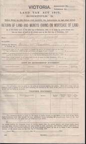
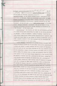
Document. KELLY & ALLSOP COLLECTION. Three copies of Schedule B of Land Tax Act of Victoria 1910. 'Return of Land and Monies Owing on Mortgage of Land.' Each form partly filled out by Arthur Allsop in pencil, ie 'Particulars of Land' section. He owns two houses in Wills St and a vacant block of land at Pyke/Brodie Streets. Instructions to taxpayers 'Every owner of land must furnish a return before 1st March 1911 of all lands owned on 31 Dec 1910.'Taxation Office of Victoriabusiness, stockbroker, kelly & allsop, kelly & allsop collection, victoria land tax act 1910, schedule b -
 Bendigo Historical Society Inc.
Document - MCCOLL, RANKIN AND STANISTREET COLLECTION: DEBORAH EXTENDED GOLD MINES NL, AGREEMENT, 1940
McColl Rankin & Stanistreet, Deborah Extended Gold Mines NL. Herbert Jackson Leed & Others with Eric Raymond Grelis and Deborah Extended Gold Mining Company No Liability. Agreement/lease lands in the mining district of Bendigo Parish of Sandhurst County of Bendigo described in Gold mining Lease Number 10902 Bendigo entered into the Register Book Volume 320 Folio 35337 at the office of Titles at Melbourne. Agreement Dated: 24/ 7/1940. Original and copy same Envelope to Mr J Stanistreet, Charing Cross, Bendigo, Vic., 3550 also included.organization, business, mine, mccoll rankin & stanistreet, deborah extended gold mines nl. herbert jackson leed & others with eric raymond grelis and deborah extended gold mining company no liability. agreement/lease 10902 bendigo 1940 -
 Clunes Museum
Document - LAND LICENCE
.1 LICENCES FOR DEPARTMENT OF LANDS AND SURVEY - OCCUPATION BRANCH. LICENCE NO 315892 TO 315901. 25 FEBRUARY 1901 TO FEBRUARY 1902 STAPLED TOGETHER .2 LAND ACT 1869 SEC 20 BOOK 88. ON SPINE "THE CROWN - LAND ACT1869. SEC 20. 88 RECEIPTS FROM REVENUE OFFICE NO 2 TO 118 RECEIPTS 119 TO 249 HAVE NOT BEEN USED, THEY ARE CUT IN HALF.2 WHITE ROUND STICKER WITH "5" ON FRONTdepartment of lands and survey, land act 1869, occupation branch, revenue office -
 Victorian Aboriginal Corporation for Languages
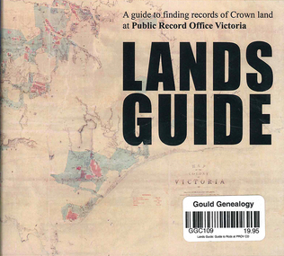
CD-ROM, Public Record Office Victoria, Lands guide : a guide to finding records of Crown land at Public Record Office Victoria, 2009
... of Crown land at Public Records Office Victoria. Lands guide ...A Guide to finding records of Crown land at Public Records Office Victoria.CD-ROM -
 Whitehorse Historical Society Inc.
Document - Report, Nunawading land, 01/10/1855
Photocopies of 3 sheets of documents in the Public Record Office listing the first land purchases in Nunawading. Headed: 'Final Report of a sale by public auction of suburban and country lands held at Melbourne on the 22nd October 1855'.williams, william, cousens, james, heading, nalborough, phillip, riley, patrick, blood, thomas, cook, holland, john, lobb, burrell, charles, land subdivision -
 Ballarat Heritage Services
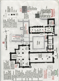
Plan, Lanercost Priory, Digital copy made 2016
Lanercost Priory was founded around 1169 by Robert de Vaux, and was home to an order of Augustinian canons until 1538 when is was dissolved by Henry VIII. In 1542 the priory and lands were granted to Thomas Dacre, an illegitimate son of Thomas, Lord Dacre. Mason's marks can be found throughout the undercroft. Plan on white paper with black and red ink printing and a drawingEnglish Heritage Lanercost Priorymason's marks, marks, stone marks, stonemasons, lanercost, priory, plan, 1169 -
 Ballarat Heritage Services
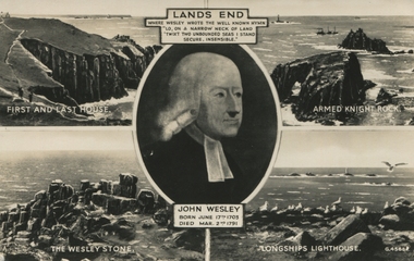
Postcard, Lands End with picture of John Wesley
... Office goldfields Lands End with picture of John Wesley Postcard ... -
 Ballarat Heritage Services
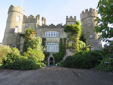
Digital photograph, Gravestones at Malahide Castle, Ireland, 2016, 09/2016
Generations of the Talbot family have called Malahide Castle home. They played significant roles in Irish political and social life. Set in 260 acres the castle is only 10 minutes from Dublin airport. https://www.malahidecastleandgardens.ie/ The estate began in 1185, when Richard Talbot, a knight who accompanied Henry II to Ireland in 1174, was granted the "lands and harbour of Malahide." The oldest parts of the castle date back to the 12th century and it was home to the Talbot family for 791 years, from 1185 until 1976, the only exception being the period from 1649–60, when Oliver Cromwell granted it to Miles Corbet after the Cromwellian conquest of Ireland; Corbet was hanged following the demise of Cromwell, and the castle was restored to the Talbots. The building was notably enlarged in the reign of Edward IV, and the towers added in 1765. The estate survived such losses as the Battle of the Boyne, when fourteen members of the owner's family sat down to breakfast in the Great Hall, and all were dead by evening, and the Penal Laws, even though the family remained Roman Catholic until 1774. In 1918 during the First World War a mooring-out base for airships was established in the grounds of the castle, used by airships from RNAS Anglesey in Wales which conducted anti-submarine operations in the Irish Sea. There were plans to base airships here from 1919, but these were abandoned at the end of the war.[1] In the 1920s the private papers of James Boswell were discovered in the castle, and sold to American collector Ralph H. Isham by Boswell's great-great-grandson Lord Talbot de Malahide. Malahide Castle and Demesne was eventually inherited by the 7th Baron Talbot and on his death in 1973, passed to his sister, Rose. In 1975, Rose sold the castle to the Irish State, partly to fund inheritance taxes. Many of the contents, notably furnishings, had been sold in advance, leading to considerable public controversy, but private and governmental parties were able to retrieve some. https://en.wikipedia.org/wiki/Malahide_CastleDigital photographsgravestones, malahide castle, ireland, cemetery, malahid castle; talbot; ireland; richard talbot; dublin -
 Ballarat Heritage Services
Digital Photograph, Malahide Castle, Ireland, 2016, 09/2016
Generations of the Talbot family have called Malahide Castle home. They played significant roles in Irish political and social life. Set in 260 acres the castle is only 10 minutes from Dublin airport. https://www.malahidecastleandgardens.ie/ The estate began in 1185, when Richard Talbot, a knight who accompanied Henry II to Ireland in 1174, was granted the "lands and harbour of Malahide." The oldest parts of the castle date back to the 12th century and it was home to the Talbot family for 791 years, from 1185 until 1976, the only exception being the period from 1649–60, when Oliver Cromwell granted it to Miles Corbet after the Cromwellian conquest of Ireland; Corbet was hanged following the demise of Cromwell, and the castle was restored to the Talbots. The building was notably enlarged in the reign of Edward IV, and the towers added in 1765. The estate survived such losses as the Battle of the Boyne, when fourteen members of the owner's family sat down to breakfast in the Great Hall, and all were dead by evening, and the Penal Laws, even though the family remained Roman Catholic until 1774. In 1918 during the First World War a mooring-out base for airships was established in the grounds of the castle, used by airships from RNAS Anglesey in Wales which conducted anti-submarine operations in the Irish Sea. There were plans to base airships here from 1919, but these were abandoned at the end of the war.[1] In the 1920s the private papers of James Boswell were discovered in the castle, and sold to American collector Ralph H. Isham by Boswell's great-great-grandson Lord Talbot de Malahide. Malahide Castle and Demesne was eventually inherited by the 7th Baron Talbot and on his death in 1973, passed to his sister, Rose. In 1975, Rose sold the castle to the Irish State, partly to fund inheritance taxes. Many of the contents, notably furnishings, had been sold in advance, leading to considerable public controversy, but private and governmental parties were able to retrieve some. https://en.wikipedia.org/wiki/Malahide_Castle, TalbColour photograph of Malahide Castle, Ireland.malahide castle, ireland, talbot, richard talbot -
 Vision Australia
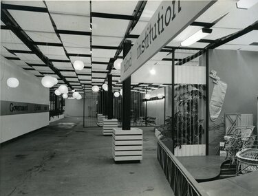
Photograph - Image, Queensland Blind Institution display at exhibition, 1962?
... C2-4138 Reproduced by Photo Section, Survey Office, Dept... Fundraising C2-4138 Reproduced by Photo Section, Survey Office, Dept ...Part of a display by the Queensland Blind Institution (?) as part of a exhibition. Neither the full name of the organisation nor the exhibition are known, however a sign on the opposite wall reads "Government Exhibit 1962". Cane chairs, an ironing board cover, coat hangers, a cane cot and a cane screen are viewable to the far right of the image. The remaining view is of an empty space awaiting exhibitors.1 x B/W photograph of exhibition spaceC2-4138 Reproduced by Photo Section, Survey Office, Dept. Public Lands, QLD.queensland industrial institute for the blind, fundraising -
 Vision Australia
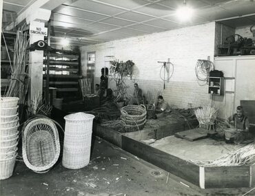
Photograph - Image, Queensland Industrial Institution for the Blind workshops, July 1965
... for the Blind by the Survey Office, Dept of Lands. 1 - The basket shop... by the Survey Office, Dept of Lands. 1 - The basket shop. From left ...Four images taken of the Queensland Industrial Institute for the Blind by the Survey Office, Dept of Lands. 1 - The basket shop. From left to right: Merv Campbell making a linen basket, Dave Valoniti (?) making a waste paper basket, Phil Woods making a clothes basket and Bill Smith making a wastepaper basket. Examples of finished linen, cot and cane baskets sit to the left of the image. 2- The basket shop on the other side of the building. Unfortunately no individuals have been identified. 3 - Shop foreman Ron Blinco working at a brush making machine. 4-6 - Queensland Industrial Institution for the Blind truck carrying cane baskets, cots, chairs and seat frame. On the door of the truck reads: Health & Home Department. The side of the truck has the following painted on the sideboards: Manufacturers of Baskets, Bedding, Brooms, Brushes, Cane Furniture, Coir Mat & Matting.6 x B/W photographs of men and equipmentC2-5792, C2-5794, C2-5795,C2-5799queensland industrial institute for the blind, merv campbell, dave valoniti, phil woods, bill smith, ron blinco -
 University of Melbourne, Burnley Campus Archives
Plan, Plan of Richmond Park, 1886-1948
(1) Black and white photographed copy of an original coloured plan. Plan of Richmond Park with Horticultural Society Gardens marked in. Includes additional land which became the Field Station. Stamp, "Neg. 18375 Department of Lands and Survey Photographed at the Central Plan Office 1/1 Plate 7.12.48". Original plan dated 19.11.86 showing land, "Permanently Preserved for the Gardens." (2) Also 2 photocopies, 1 reduced - possibly used in a publicationgardens, richmond, horticultural society of victoria -
University of Melbourne, Burnley Campus Archives
Plan - Photocopy, Proposed Reserve for Horticultural and Experimental Garden in the Survey Paddock Richmond, 1862-1948
Photocopy of Plan Gazetted 01.08.1863. From Central Plan Office Department of Natural Resources.Signed by Clement Hodgkinson, Deputy Surveyor General. Stamped Department of Lands and Survey 7.12.48 Neg.18377. Handwritten notes on it, "Melb Roll 23 R.19(A)"exprimental gardens, burnley -
 University of Melbourne, Burnley Campus Archives
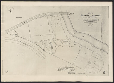
Photograph - Plan of Burnley Gardens
"This plan is a copy of a copy of the survey made by Mr. Turner in 1926. The original plan and field notes are missing _ file Rs 3529" Signed by _signature unreadable_ -
Tarnagulla History Archive
Telegram, March 1862
Donald Clark Collection. A large lot of papers, including this and many other telegrams, were apparently found in the ceiling cavity of the Sandy Creek/Tarnagulla Post and Telegraph Office in the later 20th Century, during building works.Telegram sent from Tarnagulla Telegraph Office from Chas Harding to Frederic Harding at the Department of Lands a& Survey, Melbourne. Text reads "Wait no selling. Gold struck in works'. -
 Department of Energy, Environment and Climate Action
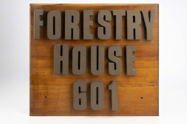
Forestry House Sign
Forestry House was the fist time that Forests Commission Head office staff had been housed in a purpose built building in Melbourne 601 Bourke street is on the corner of Bourke and King streets The building opened in the late 1970s but staff relocated in the late 1980s after the formation of the Department of Conservation Forests and Lands (CFL)Large wooden sigh from outside Forestry House at 601 Bourke Streetforests commission victoria (fcv), forest signs -
 Federation University Historical Collection
Map - Geological Survey, J. Phillips, Geological Survey of Victoria - Ballarat, 1857, 10/1858
Geological map of the Ballarat District featuring four colours.ballarat, geological, geology, geological plan, main road, camp, golden point, pennyweight hill, clayton hill, ballaarat cemetery, bakery hill, specimen hill, soldiers hill, nightingale lead, native youth black hill flat, white flat, mining, mines, eureka lead, old post office hill -
MYLI My Community Library
Map - Nar Nar Goon County of Mornington Map, 1944, H.E Daw - Government Printer, June 1944
... Department of Lands and Survey (The Office of Titles)... in the Crown grant as issued by the Lands Department. / After the issue ...This was a map made in the period before Cardinia shire was created in 1994. With intricate labelling of lot allocations, this map is a invaluable research potential for understanding the settlement of the area and its development in the first half of the 1900s. A paper map with yellow shaded areas and black ink.On Left Side: Pakenham (lot numbers throughout the map) Top side: Gembrook, Tonimbuk Right Side: Bunyip, Koo-wee-rup East Bottom Side: By Authority: / H.E. Daw Government Printer / Melbourne Koo-wee-rup Bottom Right Corner: NOTE: The allotments colored brown are freehold. In respect of which the name. The Area, and the Date where given, are the particulars set out in the Crown grant as issued by the Lands Department. / After the issue of the Crown Grant, all subsequent dealings are effected at the office of titles, Queen Street, Melbourne, and particulars as to present registered ownership, boundaries, subdivisions, etc., may be obtained by search at that office. / This plan has been compiled from the Lands Department Record as at June 1944 / Nar-Nar-Goon / County of Mornington / Drawn and reproduced at the department of lands and survey, Melbourne Price 2/. June 1944 h.e. daw, map, nar-nar-goon, county of mornington, pakenham, koo-wee-rup -
 Bendigo Historical Society Inc.
Document - MISS G ALICE JONES COLLECTION: ACCOUNT
The Liquidator. Bendigo amalgamated Goldfields Ltd. To Miss G. Alice Jones. Re Sale of Lands by Auction on 11 Aug. 1938. Pink paper with dates, July 4, 5, 6, 7, 15-21, 23, Aug 4 to 9, Oct 20 to 1938 to Apl 2 1939, Oct 20 to Nov 15, 1939, and 19 August 1941. Account for work involved in sale of land, transfer, letters, and problems of some purchasers refusing to sign. Total cost £18. 1. 0. R702 posted 19/8/41.the miss g alice jones collection - account, bendigo amalgamated goldfields ltd., j. h. curnow & sons, k murdoch, bendigo a 1 co., state land tax office, n bear, o'halloran, rooney, power, huxtable, gray, mcwilliams, eaglehawk municipality, municipality of bendigo -
 Bacchus Marsh & District Historical Society
Map, Maddingley Township, Parish of Parwan, 1880s
This map is dated Sept. 6th 1856. However places in the township of Maddingley which did not appear until the late 1880s such as the Bacchus Marsh Railway Station and line are shown on this map in their correct locations. This suggests the map has been derived from an earlier map. An earlier date of 1843 with a surveyor's name preceding it can also be seen on the map. The map is important because it indicates the location and dimensions of early but now discontinued use of land such as the showgrounds and police paddock and a site reserved for the Church of England which was not ultimately used for a permanent church. A single page paper map showing land allotments, streets, rivers, creeks, park lands, the railway line and Bacchus Marsh railway station in the township of Maddingley. The map is pasted into a bound volume containing 76 maps or plans in total. Bottom of Map: Surveyor-General's Office, Melbourne, Sept 6th, 1856bacchus marsh victoria maps, maddingley victoria maps, land use, maddingley victoria history -
 Eltham District Historical Society Inc
Newsletter, Newsletter, No. 25 July 1982
Contents: • Next meeting – Examination and collation of historical photographs • Former Falkiner Cottage • Other Council matters o Former Lands Department building o Development of Council Pound site o Maroondah Aqueduct The Shire of Eltham Historical Society was formed in October 1967. The first newsletter of the Society was issued May 1978 and has been published continuously ever since on a bi-monthly basis. With the cessation of the Shire of Eltham in late 1994, the Society's name was revised to Eltham District Historical Society and this name first appeared with issue No. 103, July 1995. The collection of the Society's newsletters provides a valuable resource on the history of the Society's activities, office bearers and committee members, guest speakers and subjects of historical interest pertinent to the former Shire of Eltham and the Eltham District.A4 photocopied newsletter distributed to membersnewsletter, eltham district historical society, shire of eltham historical society -
 Forests Commission Retired Personnel Association (FCRPA)
Beechworth FCV District office sign
This sign proudly hung outside the Forests Commission Victoria (FCV) Beechworth office which is now site of the Forestry Heritage Museum. The granite building in the Beechworth's historic precinct was once the Gold Warden's Office and is one of the town's original buildings. The FCV was the main government authority responsible for management and protection of State forests in Victoria between 1918 and 1983. The Commission was responsible for ″forest policy, prevention and suppression of bushfires, issuing leases and licences, planting and thinning of forests, the development of plantations, reforestation, nurseries, forestry education, the development of commercial timber harvesting and marketing of produce, building and maintaining forest roads, provision of recreation facilities, protection of water, soils and wildlife, forest research and making recommendations on the acquisition or alienation of land for forest purposes″. The Forests Commission had a long and proud history of innovation and of managing Victoria's State forests but in September 1983 lost its discrete identity when it was merged into the newly formed Victorian Department of Conservation, Forests and Lands (CFL) along with the Crown Lands and Survey Department, National Park Service, Soil Conservation Authority and Fisheries and Wildlife Service. After the amalgamation the management of State forests and the forestry profession continued but the tempo of change accelerated, with many more departmental restructures occurring over the subsequent four decades. Responsibilities are currently split between the Department of Energy, Environment and Climate Action (DEECA), Forests Fire Management Victoria (FFMV), Parks Victoria, Melbourne Water, Alpine Resorts Commission, the State Government-owned commercial entity VicForests and the privately owned Hancock Victorian Plantations (HVP).Large office sign. Hand painted in traditional FCV mission brown and gold colour scheme.forests commission victoria (fcv), forest signs -
 Bendigo Historical Society Inc.
Document - LETTER DESCRIBING BENDIGO'S GRANDEST BUILDINGS
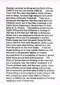
Bendigo's Grandest Buildings are the Public Offices (1883-7) and the Law Courts (1892-6). Like the Town Hall they were described as Italian Renaissance in Design, but have high mansard roofs which give them a distinctly French air. They are so pompously Bendigonian that they stand well with Vahland's work, but in fact they originated in the Public Works Department, the architect for both being W.G. Watson. The building containing the Public Offices and Post Office has a frontage of 155 feet to Pall Mall and 100 feet to Williamson Street, and it was designed to include the post and telegraph offices and the postmaster's quarters. Public access was from the porch facing Pall Mall, and on the first floor were the police, water supply and crown lands departments, reached by a stair from the porch on the short façade. It was the largest building of its type outside of Melbourne, and was built in the grandest fashion of ornately stuccoed brick on a foundation of Harcourt granite, faced above ground level with bluestone. The floors of the porches and landings of the main stair are of encaustic tiles, the interior woodwork is of French polished cedar, and the major public rooms have coffered and enriched ceilings and cornices, and ornamentally panelled walls divided by pilasters. The building is surmounted by a tower rising to 130 feet, containing a great clock made by Thomas Gaunt of Melbourne, the chimes played on five bells weighing a total of three tons.bendigo, buildings, state offices -
 Linton and District Historical Society Inc
Photograph, John O'Meara on his Wedding Day
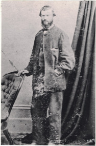
John O'Meara on his Wedding Day, August 1865. Born 1833, Tipperary, Ireland. Son of Patrick O'Meara and Ann O'Brien. Married Maria O'Brien. Died 11 Nov 1910. J.J. O'Meara. According to the first Lands Dept. plan of the area, a J.J. O'Meara is shown as owner of lot 13 in Sussex Street, Linton, which is part of the block now occupied by the Shire Offices. In an early Post Office Directory (1868), J.J. O'Meara is listed as "Timber Merchant", Sussex Street, Linton.Black and white copy of original portrait showing a man, standing with his right hand resting on the back of a chair. He is wearing a light coloured suit, white shirt and dark bow tie. His left hand is in the pocket of his jacket, which is done up with a single button on the top of the jacket. A wall and curtain in the background. His hair sticks out at the sides and he has a beard and mustache."John O'Meara".john o'meara, j.j. o'meara, weddings -
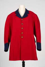 City of Greater Bendigo - Civic Collection
Uniform - Postal Workers Uniform, c. 1890
The post office was situated on site at this Pall Mall location from 1887 until 1997. Early on the building housed a variety of government services included sub treasury, police, water, lands, post and telegraph and quarters for the resident postmaster. With federation in 1901 the building became the Commonwealth Postmaster - General's Department's Bendigo Post Office. In 1975 postal services were taken over by the Australian Postal Commission and in 1989 Australia Post was corporatised.Colonial era postal uniform possibly worn by the Post Master at the Bendigo Post Office. Single breasted frock coat. Scarlet jacket with contrasting royal blue collar, lapel cuffs and pocket flap. Body and skirt section lined with lighter red cotton fabric, pockets lined with cream coloured cotton fabric, sleeves lined with brown, blue and white striped cotton fabric. Five brass buttons on front, two brass buttons on the top of the centre back pleat, each button with a crown and VR. Typically of frock coats of the 19th century the coat has a two distinct sections, a top jacket and skirt. The shoulder seam is bias cut and runs at an angle down the back. The back is cut in four sections and the skirt in two sections. There are no side seams in the coat, instead there is a seam placed further back than the actual side of the wearer.Any possible text on the label on inner top of collar has disappeared.australia post, city of bendigo post office, city of greater bendigo commerce -
Clunes Museum
Map - MAPS, A.C. BROOKS GOVERNMENT PRINTER MELBOURNE
.1 PARISH OF CLUNES, COUNTY OF TALBOT. (3 COPIES) (1) STAMP: DRAWING OFFICE RECORDS COPY, STATE ELECTRICITY COMMISSION OF VICTORIA. ELECTRICITY DEPARTMENT (THIS PLAN MUST NOT BE TAKEN FOR FIELD USE. PLEASE DO NOT DEFACE) C71 ON LEFT BOTTOM CORNER, CLUNES SHEET 1 (2) '19' HANDWRITTEN ON ALL FOUR CORNERS AND PLASTIC TAB FOR HANGING (3) PLASTIC TAB FOR HANGING .2 MAP BECKWORTH COUNTY OF TALBOT (3 COPIES) (1) IN RED: B-61. L.4855. THE ALLOTMENTS COLOURED BROWN ARE FREEHOLD (2) WITH PLASTIC TAB FOR HANGING (3) WITH PLASTIC TAB FOR HANGING. '14' HAND WRITTEN IN ALL 4 CORNERS AND VARIOUS PENCIL NOTATIONS ON THE MAP..1.2 DRAWN AND REPRODUCED AT THE DEPARTMENT OF LANDS & SURVEY MELBOURNE. PRICE 2/- .1 IN PENCIL ON BOTTOM ' 211 ' 20%parish of clunes, electricity supply department, beckworth