Showing 4653 items
matching property development
-
 Whitehorse Historical Society Inc.
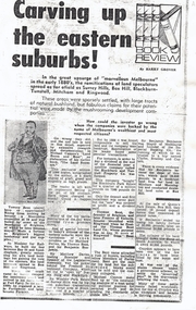
Print - Article, Carving up the Eastern Suburbs, 8/11/1972 12:00:00 AM
Photocopy of book review of Michael Cannon's 'Land Boom and Bust' describing the work of land speculators in the 1880's.Photocopy of book review of Michael Cannon's 'Land Boom and Bust' describing the work of land speculators in the 1880's. The involvement of senior politicians is discussed. Sir Matthew Davies and the Freehold Investment Company in Blackburn and the sale of the Blackburn Park Estate is mentioned. A copy of a Queen's Park, Box Hill 10 pound deposit receipt is illustrated.Photocopy of book review of Michael Cannon's 'Land Boom and Bust' describing the work of land speculators in the 1880's. davies, matthew henry, sir, bent, thomas, benjamin, freehold investment and banking company of australia ltd., blackburn and tunstall property co., queens park estate, box hill, residential development -
 Whitehorse Historical Society Inc.
Newspaper - Article, Heritage Buildings, 23/06/1999
Building our history. 3 Whitehorse properties included in the Whitehorse Council Heritage Overlay. Article in the Whitehorse Gazette.city of whitehorse, historic buildings & sites, residental development, commercial buildings, dulce domum blackburn road, blackburn, churchill street mont albert, robs cycles & sports, robinson, george, lewis, greg, cahill, bernadette, lewis family -
 Whitehorse Historical Society Inc.
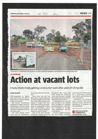
Article, Action At Vacant Lots, 2017
Two vacant properties in Blackburn Road, Blackburn at Nos 22 and 50 are finally being redeveloped. At No. 50 a child care centre is being constructed and at No. 22 a housing and retail development is expected.blackburn road, blackburn no. 50, blackburn no. 22, blackburn -
 Whitehorse Historical Society Inc.
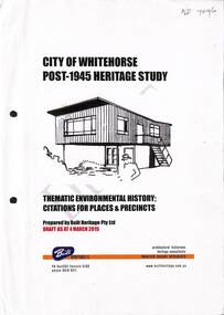
Book - Heritage Study, City Of Whitehorse Post-1945 Heritage Study, 4 March 2015
City of Whitehorse Post-1945 Heritage Study, dated 4 March 2015A4, 285 pages. A draft copy of the City of Whitehorse Post-1945 Heritage Study, dated 4 March 2015 (on front page) plus published copy of Appendix 2 pages 275-285non-fictionCity of Whitehorse Post-1945 Heritage Study, dated 4 March 2015 city of whitehorse, post war buildings, built heritage pty ltd, historic buildings, post war development, houses, architectural styles -
 Whitehorse Historical Society Inc.
Book - History, Wandinong Sanctuary Advisory Committee, The Wandinong Story (2023), October 2023
The book describes the origins of Wandinong Sanctuary, Blackburn as a home for the Hookes family from 1913 and its transformation into a public park in 1973.Color Reprint of 110 pp, with a new front page and new color photographs of the vegetation. non-fictionThe book describes the origins of Wandinong Sanctuary, Blackburn as a home for the Hookes family from 1913 and its transformation into a public park in 1973.wandinong sanctuary, hooke janet, hooke arthur -
 Whitehorse Historical Society Inc.
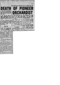
Article, Death of Pioneer Orchardist, 10/05/1967
Edward Henry (Harry) Pearce died in April 1967non-fictionEdward Henry (Harry) Pearce died in April 1967pearce harry, pearce edward h, springfield road blackburn no.106, blackburn high school, lend lease development, blackburn bowling club, woodhouse grove methodist church, old orchard shopping centre -
Bialik College
Photograph (item) - Drummond Street, Carlton, 1999, 1999
Photographs and related memo, dated 1 February 1999. The memo was written by Bialik College Development Manager Lisa Taft after visiting 273 Drummond Street, Carlton, where the school was first established, to view a painted wall before it was plastered over by the current owner of the property. She took several photographs of the wall and building. Please contact [email protected] to request access to this record.hebrew school, history, zionism -
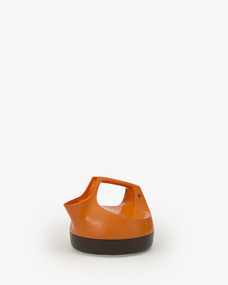 RMIT Design Archives
Domestic object - Object, General Electric KE12 Kettle, designed by Barry Hudson
The GE12 Electric Kettle was designed by Barry Hudson for General Electric and in 1978 won the Australian Design and the Prince Philip Prize awards for Australian Design. The kettle was innovative in many ways; it was an early example of an all plastic electric kettle with a single-handed opening-spout. According to design historian Ian Wong ‘The use of an integral hinge for the spout opening mechanism utilised the unique live hinge property of polypropylene, now common but at the time a novel use and very efficient to manufacture.’ The kettle was available in Carpentaria Orange, Blaze Yellow and Lime Green with a contrasting base. Barry Hudson (1935-2008) studied Mechanical Engineering at the Melbourne Technical College (MTC). In the 1970s he was Research and Development Manager at General Electric, and he also worked with the industrial design practice Rosenfeldt, Gherardin and Associates. He established Barry Hudson Industrial Design in the 1980s and began a teaching career at the former MTC, now known as RMIT University. Ann Carew, 2020 1978 the Kettle won an Australian Design Award and the Prince Philip Prize for Australian Design.Orange and brown electric kettlekettle, industrial design, rmit university, domestic appliances -
 Southern Sherbrooke Historical Society Inc.
Information folder - Glen Park
Folder containing information pertaining to the history of Glen Park homestead, Menzies Creek. Contents: -two pages photocopied from "That Little Train" by Peter Cuffley, showing four photos of Glen Park homestead and a short history of Edwin Johns at Glen Park (2 copies of each) -articles, "No. 861's full steam ahead again", photo shows Col Rees with Coonara Community School students, and "Living the dream" re. engine no. 861. On verso, "A Family Reunited", article by Emerald Tourist Railway re. locomotives, and "Colin just loves steam locomotion" re. engine no. 861. -4 letters, from Puffing Billy Railway, in support of Col Rees. -Letter, dated 19 June 1996, from Emerald Tourist Railway, re. appeal for restoration of Garratt engine. On verso, copy of certificate awarded to Col Rees for donation to appeal. -Letter, 1 June 1998, re. Garrett appeal. On verso, certificate awarded to Col & Kellie Rees for donation to appeal. -Aerial photo showing proposed property boundaries of Glen Park subdivision. -Aerial photo showing existing property boundaries of Glen Park. NB. last four items provided to society by Col Rees in support of subdivision. -Memorandum dated 2 May 2000 from Graham Whitt, Shire of Yarra Ranges, to Shire Service Centres, re proposed division of Glen Park land. -Fax, dated 13 June 2000, from Southern Sherbrooke Historical Society to Shire of Yarra Ranges, re. intention to make submission. -Letter, dated 14 June 2000, acknowledging receipt of above fax. -Submission, dated 18 June 2000, from Southern Sherbrooke HS, expressing concern re. proposed subdivision of Glen Park. -Fax, dated 27 June 2000, from Dianne Kueffer to Susan Heywood-Downard, Agenda Item 2 of the Yarra Ranges Planning Committee Agenda 14 March 2000, including detailed description of proposed subdivision and map. -Letter, dated 7 July 2000, Shire to Society, re. discussion of Glen Park subdivision by council. -Letter, dated 7 July 2000, Society to Shire, re. withdrawal of objection subject to certain conditions. -Letter, dated 14 July 2000, Shire to Society, re. council resolution to allow subdivision of Glen Park. -Letter, dated 24 October 2000, Shire to Society, stating that amendment to Planning Scheme allowing subdivision was approved by council and gazetted on 19 October 2000. -seven A3 sheets, showing house and property plans for new constructions proposed for Lot 1 of Glen Park subdivision. -diagram, hand-drawn (by Col Rees?) on lined A4 sheet, showing proposed development. -A1 sheet, Plan of feature survey of Lot 2 Blackhill Rd, Selby, dated 12 April 2000, showing contours, vegetation, proposed location of buildings, etc. -Glen Park Homestead and Cyprus Avenue, document prepared for the Shire Of Yarra Ranges by Helen Lardner Conservation & Design P/L, June 2003edwin johns, breen family, col & kellie rees, puffing billy -
 Southern Sherbrooke Historical Society Inc.
Information folder - Madigan Cottage
The buildings are probably rare remnant examples of their type in the local area and as such are significant to the settlement of Menzies Creek. The dwelling is significant as a longstanding marker of the Madigan family who were original settlers in the area. Its retention in its site close to the road boundary expresses and maintains a connection with early settlement and rural lifestyles in Menzies Creek over the last century. The old shed is of interest as a local example of bush construction, particularly in context with the cottage and farm environs. Without the life of the farm and other elements presumed now gone, its value is lessened.Folder containing information pertaining to the history of Madigan Cottage, Menzies Creek. NB: the shed was demolished in November 2001 and the cottage burned down sometime later. Contents:- Letter, Southern Sherbrooke Historical Society to Shire of Yarra Ranges, dated 9th March 2001, re. sale of property and need for it to be included in shire's Heritage Study. -Letter, shire to society, dated 20th March 2001, reply to above. -Letter, shire to society, dated 15th May 2001, follow-up to above, requesting more information. -Letter, society to shire, dated 30th May 2001, responding to above and including a copy of information previously sent to Chris Johnston, Heritage Study consultant. -Letter, society to shire, undated, noting intention to lodge an objection to proposed application for development on site. -Letter, shire to society, dated 22nd October 2001, advising of consultation meeting. -Yarra Ranges Shire Heritage Study Place Nomination form for Madigan Cottage, prepared by Marian Matta, includes nine colour photos and diagram showing where photos were taken from. -Black and white copies of photos. -A3 copy of real estate advertisement, "Mount Evergreen Estate" dated 21st April 1924. -A3 map showing proposed resubdivision boundary variation, drawn up for Mr. P. Melville, undated but 1990s. -Copy of application for a planning permit, dated 6th August 2001, including letter by Nick Jonkers describing proposed new buildings, site map showing current vegetation, letter re. proposed removal of vegetation, subdivision plan dated March 1998, and larger scale map printed from shire website on 10th August 2001. -5 A3 sheets showing site and house plans drawn up for Mr & Mrs N. Jonkers, dated July 2001.madigan cottage, menzies creek, madigan family, mount evergreen, patrick madigan -
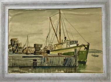 Queenscliffe Maritime Museum
Painting - Framed Watercolour, Fishermen's Pier Queenscliff
Queenscliff’s first pier, then known as the Fishermen’s Pier, was completed in 1857. It was not until some thirty years later that the second Steamer Pier was constructed adjacent to the former and periodically extended from the mid to late 1880s to cope with the demand in pleasure bay steamer services. The last of these extensions was to provide a dog-leg construction and the extant shelter shed. 1960 witnessed the demolition of the original Fishermen’s Pier - by this time having been extended in the late nineteenth and early twentieth centuries to the equivalent length of the Steamer Pier - and saw the relocation of its 1926-29 lifeboat house to the Steamer Pier, now Queenscliff Pier. The mid to late 2000s saw Queenscliff Harbour undergo large-scale redevelopment in order to deepen its waters for pleasure craft and increase its berths to over 300. This was met with strong community opposition, largely with concerns for neighbourhood character and perceived cause for gentrification its stakeholders would impart. With early construction estimates of $20 million dollars, this figure had almost doubled upon realisation. (Lovell Chen Architects. ‘Individual Property Citation’, Queenscliffe Heritage Study, 2009.) (Freya Mitchell, ‘Queenscliff residents fight a tide of development sweeping the historic town’ ABC radio, 15 April 2005).Fishermen's Pier Watercolour painting of Fishermen's Pier in Queenscliffwatercolour, fishermen's pier, queenscliff -
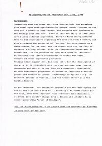 Bendigo Historical Society Inc.
Document - MERLE HALL COLLECTION: ARTS BENDIGO: RE DISCUSSION ON ''FORTUNA'' OCT 15TH 1999
Arts Bendigo: Re Discussion on ''Fortuna'' Oct 15th 1999 Two pages - first pages is ''Background'' (''As for ''Fortuna'', our tentative proposals for the development and use of the site could lead to it becoming a NATIONAL centre for the arts, even more important than somewhere like Monsalvat''; second page is titled ''To The City of Greater Bendigo'' - three general points arising from the one-day seminar with a request for the CoGB to approach the Department of Defence re the likelihood of the property being available for sale within the foreseeable future. -
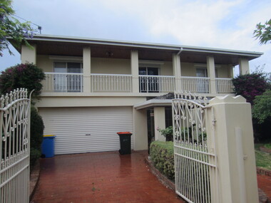
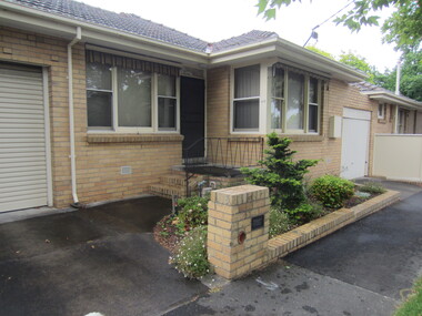
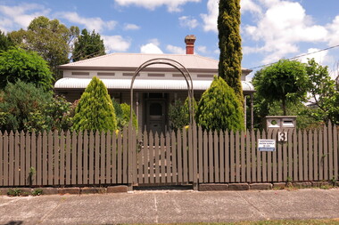
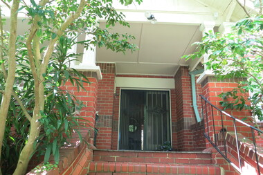
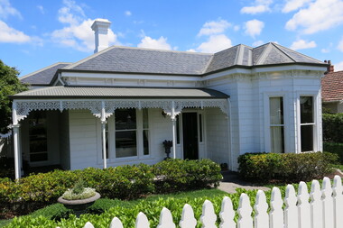
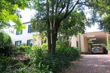
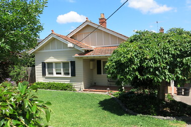
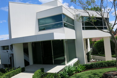
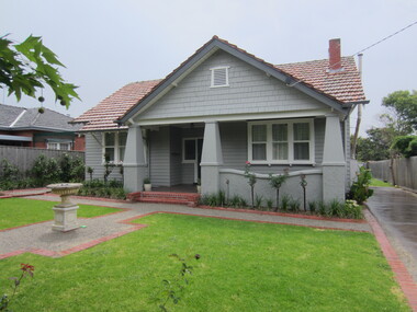 Surrey Hills Historical Society Collection
Photograph - 109 Middlesex Road, Surrey Hills, The Street Where You Live Project
Photos documenting this address as part of a photographic series undertaken by volunteer photographers during 2013 and 2014 for The Street Where You Live Project. This was organised through the Surrey Hills Neighbourhood Centre and covered the postcode 3127 in the cities of Boroondara and Whitehorse.These photos provide a snapshot of real estate in the suburbs of Mont Albert and Surrey Hills during a period of rapid change with many properties on large blocks demolished to create higher density residential development or renewal of single dwellings. At particular risk were properties not covered by heritage overlays, in particular interwar housing and post 1950's housing. -
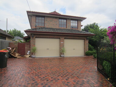
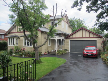
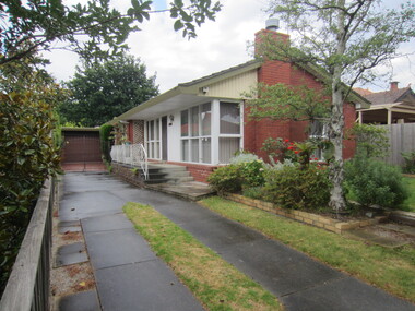 Surrey Hills Historical Society Collection
Photograph - 110 Middlesex Road, Surrey Hills, The Street Where You Live Project
Photos documenting this address as part of a photographic series undertaken by volunteer photographers during 2013 and 2014 for The Street Where You Live Project. This was organised through the Surrey Hills Neighbourhood Centre and covered the postcode 3127 in the cities of Boroondara and Whitehorse.These photos provide a snapshot of real estate in the suburbs of Mont Albert and Surrey Hills during a period of rapid change with many properties on large blocks demolished to create higher density residential development or renewal of single dwellings. At particular risk were properties not covered by heritage overlays, in particular interwar housing and post 1950's housing. -
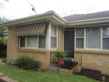
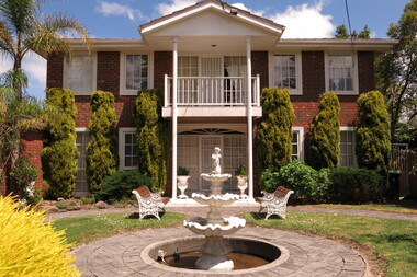
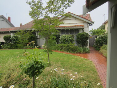 Surrey Hills Historical Society Collection
Photograph - 111 Middlesex Road, Surrey Hills, The Street Where You Live Project
Photos documenting this address as part of a photographic series undertaken by volunteer photographers during 2013 and 2014 for The Street Where You Live Project. This was organised through the Surrey Hills Neighbourhood Centre and covered the postcode 3127 in the cities of Boroondara and Whitehorse.These photos provide a snapshot of real estate in the suburbs of Mont Albert and Surrey Hills during a period of rapid change with many properties on large blocks demolished to create higher density residential development or renewal of single dwellings. At particular risk were properties not covered by heritage overlays, in particular interwar housing and post 1950's housing. -
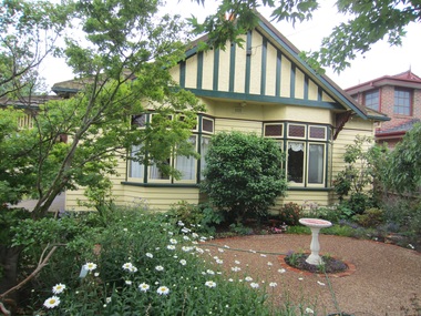
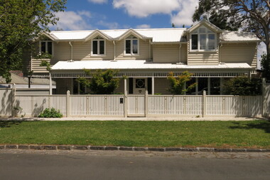
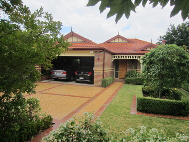 Surrey Hills Historical Society Collection
Photograph - 112 Middlesex Road, Surrey Hills, The Street Where You Live Project
Photos documenting this address as part of a photographic series undertaken by volunteer photographers during 2013 and 2014 for The Street Where You Live Project. This was organised through the Surrey Hills Neighbourhood Centre and covered the postcode 3127 in the cities of Boroondara and Whitehorse.These photos provide a snapshot of real estate in the suburbs of Mont Albert and Surrey Hills during a period of rapid change with many properties on large blocks demolished to create higher density residential development or renewal of single dwellings. At particular risk were properties not covered by heritage overlays, in particular interwar housing and post 1950's housing. -
 Surrey Hills Historical Society Collection
Photograph - 113 Middlesex Road, Surrey Hills, The Street Where You Live Project
Photos documenting this address as part of a photographic series undertaken by volunteer photographers during 2013 and 2014 for The Street Where You Live Project. This was organised through the Surrey Hills Neighbourhood Centre and covered the postcode 3127 in the cities of Boroondara and Whitehorse.These photos provide a snapshot of real estate in the suburbs of Mont Albert and Surrey Hills during a period of rapid change with many properties on large blocks demolished to create higher density residential development or renewal of single dwellings. At particular risk were properties not covered by heritage overlays, in particular interwar housing and post 1950's housing. -
 Surrey Hills Historical Society Collection
Photograph - 114 Middlesex Road, Surrey Hills, The Street Where You Live Project
Photos documenting this address as part of a photographic series undertaken by volunteer photographers during 2013 and 2014 for The Street Where You Live Project. This was organised through the Surrey Hills Neighbourhood Centre and covered the postcode 3127 in the cities of Boroondara and Whitehorse.These photos provide a snapshot of real estate in the suburbs of Mont Albert and Surrey Hills during a period of rapid change with many properties on large blocks demolished to create higher density residential development or renewal of single dwellings. At particular risk were properties not covered by heritage overlays, in particular interwar housing and post 1950's housing. -
 Surrey Hills Historical Society Collection
Photograph - 115 Middlesex Road, Surrey Hills, The Street Where You Live Project
Photos documenting this address as part of a photographic series undertaken by volunteer photographers during 2013 and 2014 for The Street Where You Live Project. This was organised through the Surrey Hills Neighbourhood Centre and covered the postcode 3127 in the cities of Boroondara and Whitehorse.These photos provide a snapshot of real estate in the suburbs of Mont Albert and Surrey Hills during a period of rapid change with many properties on large blocks demolished to create higher density residential development or renewal of single dwellings. At particular risk were properties not covered by heritage overlays, in particular interwar housing and post 1950's housing. -
 Surrey Hills Historical Society Collection
Photograph - 116 Middlesex Road, Surrey Hills, The Street Where You Live Project
Photos documenting this address as part of a photographic series undertaken by volunteer photographers during 2013 and 2014 for The Street Where You Live Project. This was organised through the Surrey Hills Neighbourhood Centre and covered the postcode 3127 in the cities of Boroondara and Whitehorse.These photos provide a snapshot of real estate in the suburbs of Mont Albert and Surrey Hills during a period of rapid change with many properties on large blocks demolished to create higher density residential development or renewal of single dwellings. At particular risk were properties not covered by heritage overlays, in particular interwar housing and post 1950's housing. -
 Surrey Hills Historical Society Collection
Photograph - 117 Middlesex Road, Surrey Hills, The Street Where You Live Project
Photos documenting this address as part of a photographic series undertaken by volunteer photographers during 2013 and 2014 for The Street Where You Live Project. This was organised through the Surrey Hills Neighbourhood Centre and covered the postcode 3127 in the cities of Boroondara and Whitehorse.These photos provide a snapshot of real estate in the suburbs of Mont Albert and Surrey Hills during a period of rapid change with many properties on large blocks demolished to create higher density residential development or renewal of single dwellings. At particular risk were properties not covered by heritage overlays, in particular interwar housing and post 1950's housing. -
 Surrey Hills Historical Society Collection
Photograph - 118 Middlesex Road, Surrey Hills, The Street Where You Live Project
Photos documenting this address as part of a photographic series undertaken by volunteer photographers during 2013 and 2014 for The Street Where You Live Project. This was organised through the Surrey Hills Neighbourhood Centre and covered the postcode 3127 in the cities of Boroondara and Whitehorse.These photos provide a snapshot of real estate in the suburbs of Mont Albert and Surrey Hills during a period of rapid change with many properties on large blocks demolished to create higher density residential development or renewal of single dwellings. At particular risk were properties not covered by heritage overlays, in particular interwar housing and post 1950's housing. -
 Surrey Hills Historical Society Collection
Photograph - 1 St Georges Avenue, Mont Albert, The Street Where You Live Project
Photos documenting this address as part of a photographic series undertaken by volunteer photographers during 2013 and 2014 for The Street Where You Live Project. This was organised through the Surrey Hills Neighbourhood Centre and covered the postcode 3127 in the cities of Boroondara and Whitehorse.These photos provide a snapshot of real estate in the suburbs of Mont Albert and Surrey Hills during a period of rapid change with many properties on large blocks demolished to create higher density residential development or renewal of single dwellings. At particular risk were properties not covered by heritage overlays, in particular interwar housing and post 1950's housing. -
 Surrey Hills Historical Society Collection
Photograph - 1A St Georges Avenue, Mont Albert, The Street Where You Live Project
Photos documenting this address as part of a photographic series undertaken by volunteer photographers during 2013 and 2014 for The Street Where You Live Project. This was organised through the Surrey Hills Neighbourhood Centre and covered the postcode 3127 in the cities of Boroondara and Whitehorse.These photos provide a snapshot of real estate in the suburbs of Mont Albert and Surrey Hills during a period of rapid change with many properties on large blocks demolished to create higher density residential development or renewal of single dwellings. At particular risk were properties not covered by heritage overlays, in particular interwar housing and post 1950's housing. -
 Surrey Hills Historical Society Collection
Photograph - 3 St Georges Avenue, Mont Albert, The Street Where You Live Project
Photos documenting this address as part of a photographic series undertaken by volunteer photographers during 2013 and 2014 for The Street Where You Live Project. This was organised through the Surrey Hills Neighbourhood Centre and covered the postcode 3127 in the cities of Boroondara and Whitehorse.These photos provide a snapshot of real estate in the suburbs of Mont Albert and Surrey Hills during a period of rapid change with many properties on large blocks demolished to create higher density residential development or renewal of single dwellings. At particular risk were properties not covered by heritage overlays, in particular interwar housing and post 1950's housing. -
 Surrey Hills Historical Society Collection
Photograph - 4 St Georges Avenue, Mont Albert, The Street Where You Live Project
Photos documenting this address as part of a photographic series undertaken by volunteer photographers during 2013 and 2014 for The Street Where You Live Project. This was organised through the Surrey Hills Neighbourhood Centre and covered the postcode 3127 in the cities of Boroondara and Whitehorse.These photos provide a snapshot of real estate in the suburbs of Mont Albert and Surrey Hills during a period of rapid change with many properties on large blocks demolished to create higher density residential development or renewal of single dwellings. At particular risk were properties not covered by heritage overlays, in particular interwar housing and post 1950's housing. -
 Surrey Hills Historical Society Collection
Photograph - 5 St Georges Avenue, Mont Albert, The Street Where You Live Project
Photos documenting this address as part of a photographic series undertaken by volunteer photographers during 2013 and 2014 for The Street Where You Live Project. This was organised through the Surrey Hills Neighbourhood Centre and covered the postcode 3127 in the cities of Boroondara and Whitehorse.These photos provide a snapshot of real estate in the suburbs of Mont Albert and Surrey Hills during a period of rapid change with many properties on large blocks demolished to create higher density residential development or renewal of single dwellings. At particular risk were properties not covered by heritage overlays, in particular interwar housing and post 1950's housing. -
 Surrey Hills Historical Society Collection
Photograph - 6 St Georges Avenue, Mont Albert, The Street Where You Live Project
Photos documenting this address as part of a photographic series undertaken by volunteer photographers during 2013 and 2014 for The Street Where You Live Project. This was organised through the Surrey Hills Neighbourhood Centre and covered the postcode 3127 in the cities of Boroondara and Whitehorse.These photos provide a snapshot of real estate in the suburbs of Mont Albert and Surrey Hills during a period of rapid change with many properties on large blocks demolished to create higher density residential development or renewal of single dwellings. At particular risk were properties not covered by heritage overlays, in particular interwar housing and post 1950's housing. -
 Surrey Hills Historical Society Collection
Photograph - 7 St Georges Avenue, Mont Albert, The Street Where You Live Project
Photos documenting this address as part of a photographic series undertaken by volunteer photographers during 2013 and 2014 for The Street Where You Live Project. This was organised through the Surrey Hills Neighbourhood Centre and covered the postcode 3127 in the cities of Boroondara and Whitehorse.These photos provide a snapshot of real estate in the suburbs of Mont Albert and Surrey Hills during a period of rapid change with many properties on large blocks demolished to create higher density residential development or renewal of single dwellings. At particular risk were properties not covered by heritage overlays, in particular interwar housing and post 1950's housing. -
 Surrey Hills Historical Society Collection
Photograph - 9 St Georges Avenue, Mont Albert, The Street Where You Live Project
Photos documenting this address as part of a photographic series undertaken by volunteer photographers during 2013 and 2014 for The Street Where You Live Project. This was organised through the Surrey Hills Neighbourhood Centre and covered the postcode 3127 in the cities of Boroondara and Whitehorse.These photos provide a snapshot of real estate in the suburbs of Mont Albert and Surrey Hills during a period of rapid change with many properties on large blocks demolished to create higher density residential development or renewal of single dwellings. At particular risk were properties not covered by heritage overlays, in particular interwar housing and post 1950's housing.