Showing 390 items
matching along the track
-
 Marysville & District Historical Society
Photograph (Item) - Black and white photograph, Unknown
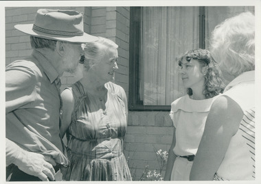
... granite and bluestone arch along the Yarra Track, a major route ...A black and white photograph taken at the unveiling of the sign placed at The Big Culvert.A black and white photograph taken at the unveiling of the sign placed at The Big Culvert. The Big Culvert is a historic granite and bluestone arch along the Yarra Track, a major route to Melbourne through the 1800s. Built in 1870 and a major piece of infrastructure for its time, the heritage listed culvert allowed water to flow under often-flooded the road. The Yarra Track is the former name of the gold fields road from Healesville to the Woods Point and Jordan Goldfields, in Victoria, Australia. A direct route via the Yarra River and the Great Divide was discovered by Rieck in September 1862 and became known as the Yarra Track. Early in 1863, the Victorian Government decided to construct a 193-kilometre (120 mile) road along the route. Its original width varied between 4 and 6 metres (12 and 20 feet), and was designed to accommodate horse-drawn vehicles. The Track involved the climbing of the Black Spur, descent into the Acheron Valley, and then through Marysville to the Cumberland where it followed the existing route.Unveiling of sign/ at "Big Culvert" In front Max Cockerrell and - Rear: second back Geoff Pope R.H.S. rear: Nancy "/ Anne "the big culvert, yarra track, victoria, healesville, wood's point goldfields, jordan goldfields, black spur, acheron valley, cumberland valley -
 Marysville & District Historical Society
Photograph (Item) - Colour photograph, 20-09-2008
... and bluestone arch along the Yarra Track, a major route to Melbourne ...A colour photograph of the entrance to The Big Culvert.A colour photograph of the entrance to The Big Culvert. The Big Culvert is a historic granite and bluestone arch along the Yarra Track, a major route to Melbourne through the 1800s. Built in 1870 and a major piece of infrastructure for its time, the heritage listed culvert allowed water to flow under often-flooded the road. The Yarra Track is the former name of the gold fields road from Healesville to the Woods Point and Jordan Goldfields, in Victoria, Australia. A direct route via the Yarra River and the Great Divide was discovered by Rieck in September 1862 and became known as the Yarra Track. Early in 1863, the Victorian Government decided to construct a 193-kilometre (120 mile) road along the route. Its original width varied between 4 and 6 metres (12 and 20 feet), and was designed to accommodate horse-drawn vehicles. The Track involved the climbing of the Black Spur, descent into the Acheron Valley, and then through Marysville to the Cumberland where it followed the existing route.the big culvert, yarra track, victoria, healesville, wood's point goldfields, jordan goldfields, black spur, acheron valley, cumberland valley -
 Marysville & District Historical Society
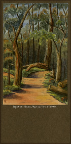
Painting (Item) - Watercolour painting, Miss I.K. Higgins, Michael Dene, Marysvile, Victoria, c1920
A watercolour painting of the Michael Dene walking track in Marysville in Victoria.A watercolour painting of the Michael Dene walking track in Marysville in Victoria by a Miss I.K. Higgins of Geelong in 1920. The Michaeldene Trail to Taggerty River Lookout is a 4.3 kilometer lightly trafficked loop trail located near Marysville, Victoria. The track is one of several walking tracks located in and around Marysville in Victoria.Michael.Dene.Marysville.Victoria Donated / by/ Elsie Stephens/ Mornington Painted by/ Miss I.K. Higgins/ of Geelong/ cc. 1920michael dene walking track, marysville, victoria, i.k. higgins, taggerty river -
 Eltham District Historical Society Inc
Photograph, Track along unopened section of Kings Road, Kangaroo Ground, 6 December 1992, 06/12/1992
... Track along unopened section of Kings Road, Kangaroo Ground... ground kings road Colour photograph Track along unopened section ...The Eltham Horse Trail: Research and Warrandyte to Kinglake: Survey of proposed route, December 1992: (3) Kangaroo Ground to KinglakeColour photographeltham horse trail (1992 survey), kangaroo ground, kings road -
 Eltham District Historical Society Inc
Photograph, Track along Glenvern Road, Panton Hill, 6 December 1992, 06/12/1992
... Track along Glenvern Road, Panton Hill, 6 December 1992... panton hill Colour photograph Track along Glenvern Road, Panton ...The Eltham Horse Trail: Research and Warrandyte to Kinglake: Survey of proposed route, December 1992: (3) Kangaroo Ground to KinglakeColour photographeltham horse trail (1992 survey), glenvern road, panton hill -
 Eltham District Historical Society Inc
Photograph, Track along Cracknells Road, Panton Hill, 6 December 1992, 06/12/1992
... Track along Cracknells Road, Panton Hill, 6 December 1992... cracknells road Colour photograph Track along Cracknells Road, Panton ...The Eltham Horse Trail: Research and Warrandyte to Kinglake: Survey of proposed route, December 1992: (3) Kangaroo Ground to KinglakeColour photographeltham horse trail (1992 survey), panton hill, cracknells road -
 Glen Eira Historical Society
Article - OUTER CIRCLE RAILWAY
This file contains five items: 1/Two copies of a document titled THE OUTER CIRCLE RAILWAY by the Royal Historical Society of Victoria and the Australian Railway Historical Society, Vic div. It details the history of the construction of the Outer Circle Railway and discussed expenses and other factors affecting the construction of the line. Notes compiled by R.K Whitehead, Research and Archives Officer Australian Railway Historical Society Victoria Division. The document includes three maps of the outer circle railway line. 2/Four newspaper articles detailing the history of the Outer Circle Railway Line. They include ten black and white images of various aspects of the railway and three line maps. The first article is titled ‘Rail Link with the Past’. In the COLLINGWOOD COURIER dated 07/10/1970, author unknown. The second article titled ‘Ghost trains of the Outer’ by Kenneth Joachim in the HERALD dated 18/04/1975. The third article is titled ‘Tracks in Time’ by Norman Thompson from NEWS, dated 13/02/1973. The fourth article is titled ‘Our Ghost Railway’ by John Townsley from the HERALD, dated 06/11/1974. 3/A letter from Victorian Railways Chief Estate Officer N.A Wigmore to the Honorary Secretary of the Caulfield Historical Society, dated 19/11/1975 regarding the leasing of land along the Outer Circle Railway Reserve from Dandenong Road to the Hughesdale Station. 4/Two copies of an article titled ‘Outer Circle Railway’ in the CAULFIELD HISTORICAL SOCIETY NEWSLETTER undated detailing the history of the outer circle line. The article includes a map of the section of the line in Caulfield. 5/A Photocopy of two images of train line locations on the Outer Circle Line. One on Warrigal Road, looking south from Ashburton dated 1936. The second is of the Black Bridge over Gardiners Creek dated 1935.outer circle railway, normanby road, caulfield station, outer circle line, rosstown junction railway, monash john, caulfield historical society, poath road, deepdene dasher, ashby dasher, dandenong road, gippsy goods, mallee root mercury, outer circle railway reserve, railway lines, railway stations, steam trains -
Glen Eira Historical Society
Article - Rosstown Railway
This file contains three items: 1/A review of the ROSSTOWN RAIL TRAIL from LIVING IN GLEN EIRA, vol. 11, 2004, Issue 4, no. 25, date and author unknown. The review explains the purpose of the Rail Trail with a brief narrative of the history behind Rosstown Sugar Mill Railway line. Concluding with information on the location of the Trail and the expected time required to walk the entire track included in the review is a map of the Rail Trail, which marks significant sites along the trail with historic pictures. 2/A newspaper article from THE AGE, dated Tuesday 21/10/1980 and written by Iola Matthews, reporting on the circumstances that led to the publication of the book RETURN TO ROSSTOWN written by Des Jowett and Ian Weickhardt. The article begins with a brief biography of the authors before moving into details of the book’s content, providing a further biography of W. Murray Ross which includes information on his financial ventures – particularly the Rosstown Rail – his marriage and children. The article includes a black and white photograph of Weickhardt and Jowett walking along the route of the railway line, an illustration of the Rosstown sugar works and a map of the area surrounding the site of the mill. 3/Three photocopies of a black and white illustration of the Rosstown sugar works from the east, undated and artist unknown.rosstown rail trail, rosstown, ross william, ross w. murray, ross murray, sugar beet mills, mills, elsternwick, land transport, railways, railway lines, railway routes, carnegie neville street, carnegie miller street, factories, market gardens, horticulture, peat, soils, land forms, topography, geology, civic issues, cone sugar industry, elsternwick plaza, elsternwick, glenhuntly road, parks and reserves, ee gunn reserve, caulfield racecourse, sportsgrounds, caulfield, carnegie, riddell parade, clarence street, aileen avenue, princes park, dover street, marara road, oakleigh road, rosanna street, murrumbeena crescent, north road, kooyong road, hawthorn road, booran road, koornang road, poath road, warragul road, railway platforms, railway buildings, bambra road, swamps, landforms, landfill, council landfill, railway bridges, bridges, railway underpasses, sporting clubs, tennis clubs, bowls clubs, rosstown railway, rosanna street reserve, maps, railway maps, living in glen eira, weickhardt ian, jowett des, caulfield south, curraweena road, oakleigh, caulfield technical school, return to rosstown, beet sugar industry, crops, land booms, land development and subdivisions, bent thomas, fink benjamin, sugar works, rosstown hotel, oamdenong road, rosstown dry cleaners, shops, rosstown road, rosstown plate, people by circumstance, migrants, accountants, occupations, professionals, the grange, real estate, grange road, financial agents, judges, rosstown estate, financial trouble, rabbit preserving, breweries, political debates, political issues, political electorates, politics, political science, debt, financial loans, court procedures, court cases, legal events and activities, malleson and riggall, widowers, seabeach railway, economics, economic deadline, depression 1890s, economic crash, mortgages, divorce, social problems, poverty, ross claude, ross roderick, world war 1914-1918, wars, military history, servicemen, australian flying corps, engineers, caulfield council, swagmen, homelessness, glenhuntly road, glenhuntly road tram, woornack road, leila road, wild cherry road, melten avenue, illustrations, steam trains, trains, horse and cart, horse-drawn transport, railway stations -
 Federation University Historical Collection
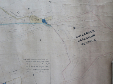
Plan, Creswick Water Supply from Bullarook to Creswick, 02/10/1869
... / descriptions of pipe and rack track. Five information boxes drawn along... track from the Bullarook Reservoir to Albert Street, Creswick ...Probably gazetted on 12 April 1872 (pg 737)Large horizontal paper plan glued in three sections to a linen backing. Coloured plan shows pipe and rack track from the Bullarook Reservoir to Albert Street, Creswick. Attached with ribbon top left are twelve pages giving bearing and lengths / descriptions of pipe and rack track. Five information boxes drawn along the bottom of plan gives extra information where pipe passes through private properties. Main heading 'Plan of Creswick Water Supply / scale eight chains to an inch / County of Talbot / Parish of Creswick'. Calculations and hand written notes in ink and pencil also on plan. Verso 'Dean Reservoir'. Signed and dated.creswick, water supply, bullurook reservoir, dean, bush inn, hesken, rivers, warner, taylor, gillard, mccormack, mcdonald, brown, naples, humbug hill sluicing co, frank rivers, w.r. taylor, j. and m. mccormack, j. mcdonald, richard brown, c. naples -
 Federation University Historical Collection
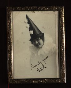
Photographs - black and white, Edith Pickford, 1917, 1917
This photo taken in 1917 was 5 years before Edith Sarah Pickford (1909 - 1967) of ''Yeoville" Clunes married Henry Smerdon [Harry] Holmes of "Sauchieburn" Ascot in 1922. At the time it was fun, fashionable and symbolic to have photo portraits taken in a clown outfit: Pierrot (Boy) with black skull caps and Columbine (Girl) with pointed hats. Pierrot, the famous character from the Italian commedia dell'arte, was portrayed by the composer A. Schoenberg as the moonstruck and fantastical clown, who is a symbol for putting on a mask to hide one's true feelings or opinions. Edith was the second youngest child, and only daughter, of John and Bessie (Robbins) Pickford, Clunes farmers. Edith’s brother, Arthur Pickford rode in the Charge of the Battle of Beersheba, a precursor to capturing Gaza in WW1. The matter of who rode in the charge at Beersheba on 31 October 1917 continues to exercise the minds of many. The charge is embedded in the Australian ethos along with Gallipoli and the Kokoda Track. [ Source: Edith's granddaughter, Jane Dyer 2024]Black and white photograph in rectangular frame with stand. Back of frame padded velvet"Sincerely yours - Edith"edith pickford, edith holmes, chatham-holmes collection, pickford collection, pierrot and columbine, portrait photograph, ww1 -
Glenelg Shire Council Cultural Collection
Photograph - Photograph - Dutton Way, 1976
Port of Portland Authority ArchivesBack: Dutton Way - pencil, lines leading to grey stamp. Location Date 30.6.76 - blue biro Time Reference 74/15 - blue biro -
Glenelg Shire Council Cultural Collection
Photograph - Photograph - Main Breakwater Construction, n.d
Port Of Portland Authority Archivesport of portland archives, portland harbour, battery point, tug boat, transit shed -
 Ringwood and District Historical Society
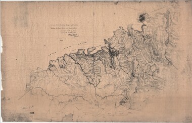
Map, Survey of Dividing Range between Yarra Yarra and Western Port - William Wedge Darke, 1843
Extract - Ringwood, Place of Many Eagles - Hugh Anderson (1974): William Wedge Darke, from Hereford, England, was a nephew of John Helder Wedge of the Port Phillip Association, who was also a surveyor. William's most important work was probably his survey of the Dividing Range and the country between the Yarra River and Western Port, completed in May 1843, and during which he made a traverse between the Mullum and Dandenong creeks along the higher ground that he labelled the "best line of road from Melbourne". This road was for many years the major route to Gippsland and to the higher country about Alexandra and Mansfield, sometimes known as White Horse Road, and now Maroondah Highway.Surveyor's relief map of features to the east of Melbourne including Yarra Yarra River, Mullum Mullum Creek, Anderson's Creek, Dandenong Creek.Transmitted to the Surveyor General with my letter of 10th May 1843 (signed) Wm Wedge Drake, Assistant Surveyor. Scale: two inches to a mile. Descriptive remarks include upstream area of Yarra River - "impassable, appears to have been formerly a lake", and to the south - "barren and scrubby swamps of the Western Port Country". Marked tracks include "best line of road from Melbourne", "track to Dandenong", "Road to Port Albert may probably be found on this range", "Best line to Upper Yarra". Several huts also marked. -
 City of Moorabbin Historical Society (Operating the Box Cottage Museum)
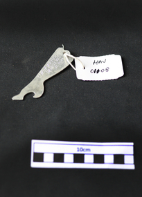
Manufactured Objects, bottle opener 'Lukey Mufflers', mid 20thC
... island car racing track. Along Shaft : LUKEY MUFFLERS / HIGHETT ...Len Lukey was a Victorian Racing Car Driver in the 1950s & 1960s and established his Car Exhaust Muffler business in his backyard in Highett c 1970. In 1964 he purchased the site and then developed and operated the Phillip Island Car Racing Track until his death 1978. He designed the Lukey Racing Car Museum and Gardens at that site. The 1959 Australian Drivers Championship was a CAMS sanctioned motor racing title for drivers of Formula Libre cars. The championship winner was awarded the 1959 CAMS Gold Star. The series was won by Victorian racer Len Lukey driving his Cooper T45 Climax and in the opening round of the series his own much modified Cooper T23 which was known as the Lukey-Bristol. Lukey was one of only a few drivers who attempted to complete the gruelling twelve race schedule, the longest in ADC history. Lukey finished just two points ahead of his season long rival, Alec Mildren from the ACT [1] (Cooper-Climax). Stan Jones, the father of F1 World Champion Alan Jones, was third in the championship, using four different cars over the course of the series. Race victories were shared around with Mildren taking three wins. Lukey, Jones and Bill Patterson each took two wins, with single victories going to Jack Brabham, Bib Stillwell and New Zealand Maserati 250F racer Ross Jensen. Jack Brabham later became F1 World Champion 3 times. A steel bottle opener with engraved advertising for Lukey Mufflers Pty Ltd HighettAlong Shaft : LUKEY MUFFLERS / HIGHETT VICTORIA / XL 3641car part manufacturers, lukey mufflers pty ltd, highett, moorabbin, bentleigh, cheltenham, early settlers, bottle openers, steel manufacturer, brabham jack, formula one grand prix champions, jones alan, phillip island car racing track. -
 City of Moorabbin Historical Society (Operating the Box Cottage Museum)
Photograph - Plateway (Wheelway) Steel, circa 1885
By the later 1800s the dirt roads in the then out-lying areas of the City of Moorabbin became dangerous, and almost impassable due to huge potholes and muddy swampy areas. The heavily laden market gardener’s carts regularly broke axles and wheels, and horses foundered on their way to the Melbourne markets. Even worse, the heavier “iron maidens”, carrying their malodorous loads of sewage from Melbourne’s inner suburbs for dumping in the outlying areas of the City of Moorabbin, also got bogged in the mire. It was decided that a practical solution to this problem was to install a metal plateway on the side of the problematic roads. In about 1887 the Moorabbin Shire Centre Road, in the Brighton East area, two parallel metal rails were installed so that the wheels of carts could run along smoothly, the horse travelled in the filled, middle area between the rails. Point Nepean Road plateway was removed in 1930 and Centre Dandenong Road plateway was removed in 1934-35. The worn plateway along Centre Road, East Brighton (now known as Bentleigh), was gradually taken up in several pieces, commencing in the the1920s, when its condition deteriorated and it caused a hazard to bikes, pedestrians, motor-cycles and the few early cars. The early steel plateway, constructed by David Munro, and opened on 23rd March 1885 by Thomas Bent, was built along Nepean Highway, between Asling St. and Bay St. The Point Nepean Track was subsequently extended into Moorabbin with branches along Centre, Cumins, South, Wickham, and Keys Roads, the total length was 13 miles. In 1908-1909 plates were laid along Centre Dandenong Road to Ross Street Bentleigh This innovative solution proved successful and was used until gradually the main roads were upgraded, and motorised vehicles started to appear. Two parallel metal rails were installed in the right hand side of a few main roads in the Shire of Moorabbin so that the wheels of heavily-loaded market gardener's carts on their way to markets in Melbourne could run along smoothly. The horse pulling the carts travelled in the filled, middle area between the rails. The Steel Plateway was constructed by David Munro, and opened on 23rd March 1885 by Thomas Bent. The wheelway first only ran along Nepean Highway, but it soon extended from Centre Dandenong Road, along Nepean road to its junction with Chapel Street, St Kilda. Later branch lines were built along Centre Road, Bentleigh as far as Warrigal Road and, according to early photographs, along Wickham Road Moorabbin as well. This innovative solution proved successful and was used until gradually the main roads were upgraded, and motorised vehicles started to appear. There was a problem with the wheelway : there was only a single set of rails and this was established on the right-hand side of the Nepean Road, travelling towards the city. Traffic FROM the city travelled on the correct or left-hand side of the road. The exception to this rule was the malodorous iron-clads, heavily riveted iron carts, generally travelling in convoy, carrying several tons of human effluent out of Melbourne to be trenched-in in the sandy soil of the Moorabbin district. Moorabbin City Council donated and installed a small section of Plateway at Box Cottage Museum in 1984melbourne, brighton, moorabbin, roads, plateway, wheelway, transport, st kilda, bent thomas, munro david, market gardens, steelway, carts horse-drawn, iron maidens, point nepean track -
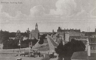 Bendigo Historical Society Inc.
Photograph - BENDIGO LOOKING EAST ALONG PALL MALL, c1915
Black and white photograph taken from the City Family Hotel Tower, looking along Pall Mall towards White Hills, Showing Alexandra fountain, toast rack tram, 1903 tram, Hustler's Royal Reserve Mine, Post Office, Law Courts behind, tram track, School of Mines tower, Shamrock Hotel and other businesses, The Beehive, Pikes Building and verandah of building in foreground. Inscriptions: 'Bendigo, looking East' in TLH corner. History: photographic copy in black and white of a colour tinted postcard, printed c1915. Copied c1970place, streetscape, pall mall, photograph, photography, bendigo, alexandra fountain, toast rack tram, bendigo law courts, bendigo post office, bendigo school of mines, beehive building, hustler's royal reserve mine -
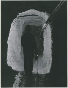 Bendigo Historical Society Inc.
Photograph - CENTRAL DEBORAH MINE, 1951 ?
black and white photo: Alfred ( Tim ) Yates ? Walking down a mine tunnel with light in hand. Male figure in tunnel carrying lamp, tracks for carts on ground, pipes on wall at right. On back Mng 47. ' miner walking along drive at Central Deborah 1951' James Lerk 26.22.1999 ' miner assumes to be Alfred ( Tim ) Yates'organization, business, central deborah mine -
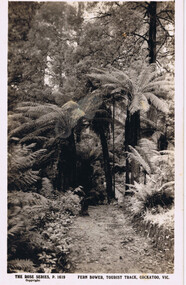 Cockatoo History & Heritage Group
Postcard, Rose Stereograph Co, Fern Bower, Tourist Track, Cockatoo, VIC
... century. The Tourist Track extended along the Cockatoo Creek ...Cockatoo's Tourist Track featured in many postcards that were produced. It was an important attraction for the many holiday makers that came to Cockatoo in the early part of last century.The Tourist Track extended along the Cockatoo Creek, crossing the creek in various parts. It seemingly followed the creek until it ended in the vicinity of Mountain Rd and started near the swimming pool.Original Postcard - The Rose Series P 1619 cockatoo creek, tourist track, rose series postcard, cockatoo victoria -
 Bendigo Historical Society Inc.
Postcard - GLADYS DEAN COLLECTION: POSTCARD, 1906 - 1908
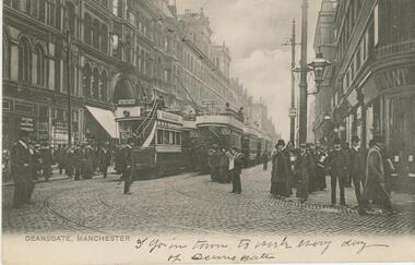
Printed black and white photographic postcard of Deansgate Manchester. Image depicts a street with trams, tram tracks, people walking and standing with buildings lining either side. There is a white 1cm border along the lower edge. The words Deansgate Manchester are printed in the border on the lower left hand side. The words 'A grim town to work everyday of Deansgate' are handwritten in the border. The reverse is blank.S Hildersheimer & Co Manchesterpostcard -
 Bendigo Historical Society Inc.
Postcard - GLADYS DEAN COLLECTION: POSTCARD, 1906 - 1908
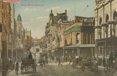
Photographic coloured postcard. Image depicts a busy city street with tram tracks down the centre, horse and carts travelling along and people walking along or crossing the road. Many buildings line both sides of the street. The words King Street Sydney are printed in red on the top left hand side.95717postcard -
 Bendigo Historical Society Inc.
Postcard - BASIL WATSON COLLECTION: BROOKLANDS MOTOR TRACK AND FLYING GROUND
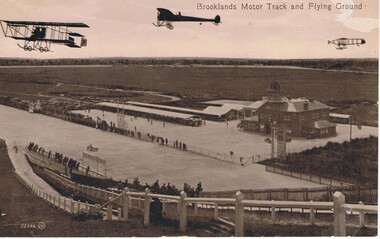
... with fencing down to the track and spectators along the fence.... with fencing down to the track and spectators along the fence. Postcard ...The postcard shows three planes flying above the Brooklands motor track with 'Brooklands Motor Track and Flying Ground'. To the right is a large two story brick building and on the left of the building is a long open covered vehicle stall. To the back are work sheds, further to the left are spectators cars and in the distance is open space with trees. Spectators line the race track both sides watching a racing car. In the foreground is a hill with fencing down to the track and spectators along the fence.Valentine Seriesaviation, civilian, brooklands motor track -
 Bendigo Historical Society Inc.
Photograph - WES HARRY COLLECTION: PALL MALL, 1972
Black and white photograph taken from the City Family Hotel tower looking north west along Pall Mall. Bottom centre is the fountain and the cenotaph, top centre is the post office clock tower.Martin Washingtonplace, bendigo, pall mall, pall mall, fountain, cenotaph, post office, tram tracks, shamrock hotel -
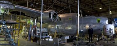 B-24 Liberator Memorial Restoration Australia Inc
Aircraft, B-24 Liberator, Consolidated Aircraft Corporation, c. 1940
This particular aircraft was modified with a search radar in the lower fuselage to help locate and track targets and was then redesignated as a B-24R model. The RAAF took A72-176 on charge in late 1944 and this saw it issued to 7 OTU (Operational Training Unit) based at Tocumwal, south west NSW. The training saw bomber crews learn how to fly the bomber, operate as a team and work with fighters. Towards the end of the war there were up to 50 aircraft located at Tocumwal along with 5000 personnel. A72-176 was noted as flown on training missions by various aircrew.This aircraft is one of the only remaining B-24 bombers in the southern hemisphere and 1 of only 8 remaining B-24 airframes still existing in the world, out of the nearly 19,000 which were originally built. The restoration honours the contribution of one of the RAAF’s main bombers of the WWII era. This restored Liberator aircraft was assembled from parts salvaged from B-24M models, manufactured during the 1940s in the USA. Made from aluminium, the plane is 68 feet long, with a wingspan of 110 feet, and is metallic silver with a distinctive blue and white target design on each side. The aircraft is powered by four wing-mounted engines, and is fitted with 10 heavy machine guns.Registration number on side of fuselage at rear of plane: 'A72-176' Inscription on side of fuselage at front of plane: 'ROYAL AUSTRALIAN AIR FORCE / US ARMY B24-10 CO / AIR FORCES SERIAL NUMBER 44-41956' aircraft, liberator, bomber, wwii -
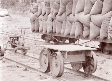 Puffing Billy Railway
C2N Type Trolly - Former Victorian Railways Gauge 2'6", circa 1910
This type of trolly is known to date from prior to 1910 and were in use before petrol engines were used to transport workmen along the railway lines. The exhibit was located at Colac in 1961, after being used on the Colac to Beech Forest and Crowes narrow gauge railway. This type of trolly was built in two versions; one for the Victorian Railways broad gauge lines, and one for the narrow gauge lines.Historic - Victorian Railways narrow gauge - track work vehicle. This vehicle was used in the days before petrol engines were used to drive vehicles transporting workmen along the railway line.C2N Type Trolly - Victorian Railways Gauge 2'6" Trolly Has a flat piece of wood that you would stand on with four metal wheels, one under each corner.c2n, trolley, victorian railways, hand power, narrow gauge, puffing billy, trolly -
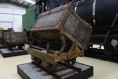 Puffing Billy Railway
Side Tipping Timber Skip, circa 1900?
Side Tipping Timber Skip Wooden Contractors Wagon. Gauge 17 inch (430mm) Typical of the many side tipping wagons used for soil and rock disposal in construction work and mining throughout Australia and the world. The wagon would be loaded with soil and pushed along a short line to the end of track where the load would be emptied out to either side. By using a central pivot the wagon’s body can be tipped either side to allow the contents to be easily removed ready for the next load.Historic - Industrial Narrow Gauge RailwayWooden bodied, steel framed side tipping skip.puffing billy, side tipping skip, industrial narrow gauge railway -
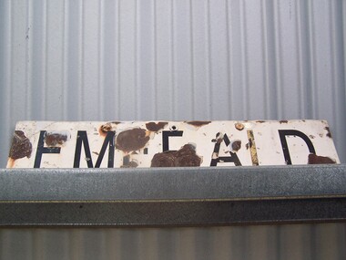 Puffing Billy Railway
Emerald Station Sign
Station Sign - Emerald Emerald Station is situated on the Puffing Billy Railway in Victoria, Australia. It was opened with the Railway on 18 December 1900 and comprised a platform track and a loop siding. A passing loop was added between the two a few years later. There was also a spur siding off the Down end of No. 3 Road. Two standard 12 ft by 20 ft timber portable station buildings with a Van Goods Shed between (all adjoining) were provided on the platform and a Goods Shed on the No. 3 Road loop siding. Other buildings included Tea Rooms, lamp room and toilets along with a cattle race and loading bank. The station building was later reduced in length by one of the portables which housed the General and Ladies' waiting rooms. Emerald today remains very similar to the early days, but has had other Roads added into a Carriage Workshops, a turntable and storage sidings. Also, a Signal and Telegraph Branch depot in the form of a large Goods Shed and a multi-purpose yard building in the form of a Locomotive Depot administration building have been added. During 2009, the station building underwent stage one of an internal restoration to its former glory. ref: https://en.wikipedia.org/wiki/Emerald_railway_station,_Victoria photos at http://www.vicrailstations.com/Gembrook/Emerald/Emerald.html Historic - Victorian Railways Station sign used at Emerald Station Station Sign - Emerald Metal rectangle Station Name Sign with white enamel back ground and black lettersEmeraldstation sign, puffing billy, emerald station -
Tatura Irrigation & Wartime Camps Museum
Painting - Painting - Water Colour, Tatura 28-7-42, Jul-42
Painted by Fred Lowen, "Dunera" boy internee. Interned in Hay 1940 and Tatura 1941-42, Purchased by Philip Mactier, a member of the Tatura Historical Society after a visit to Mr. Lowen's homeLeft side huts, gates to camp, two large trees left of centre and tent. Smaller trees on right side of track and two lights atop tall post. Fence running along horizon. Black frame with gold strip"FL" Tatura 28.7.42painting, water colour, lowen f, dunera boy, camp 3, tatura, ww2 camp 3, illustrations, watercolour -
 Uniting Church Archives - Synod of Victoria
Photograph, undated c.1980s
... the Borroloola Track, and down the Birdsville Track to the Flinders... the Borroloola Track, and down the Birdsville Track to the Flinders ...Rosalie Rayment originally trained and worked as an Occupational Therapist. Following completion of studies in Theology she worked for 11 years with the Church in Thailand. Rosalie was ordained in 1988. Fred Vanclay B.D., Dip AgS. ordained 1964 in the Presbyterian Church. Served: Queensland 1961 - 1975; Victoria 1976 - 1985 Vermont - Parkmore; Northern Territory Tennant-Barkly Patrol 1985 - 1993. Died in 2016. Adapted from the eulogy given by his son, Jerry Vanclay One of Fred’s first placements as a minister was in Mackay, North Queensland. Mackay was a wonderful place for Fred, his wife Donna and their young family. They all loved the beaches and the bush, and the children completed a significant part of their schooling there. Whilst posted in Mackay, Fred and Donna enjoyed long road trips in their modest HR Holden sedan, with the family, to Uluru, to Broome via the Borroloola Track, and down the Birdsville Track to the Flinders ranges; along the way, developing the bushcraft that would stand them in good stead later in the Tennant-Barkly Patrol. After many years in ministry in Mackay, then in Vermont, Victoria, Fred and Donna were called to the Tennant-Barkly Patrol in the Northern Territory, where he served for eight years, probably Fred’s most satisfying years. All Fred’s parishes were welcoming and rewarding, but Fred said on more than one occasion that he had a special love for the Patrol. He felt that in an urban congregation, he ministered mainly to those who came to Church, but in the Patrol he ministered to everyone, and especially to those in need. Fred loved to get involved with the day-to-day activities of his people, to develop a deeper relationship and greater understanding. Some remarked that when Fred helped, everything took longer, but they loved him and his assistance nonetheless. Fred was proud to follow in the footsteps of his predecessor Padre Fred McKay, and sometimes joked that he was “Fred the 2nd”, not Fred McKay, but “Fred from Mackay”. During his last few weeks in hospital, Fred liked to reminisce on his time in the Patrol. He joked about how he surprised the selection panel with his knowledge of bush tracks and outstations – knowledge that he had gained on those long road trips from Mackay. He reflected that many aspects of his life were good preparation for his time in the Patrol. After their Patrol, Fred and Donna retired to Mt Waverley, in Melbourne, but they were both restless in retirement, and undertook supply ministries in Wedderburn, Kerang and North Cairns, and made several long journeys into the interior and into their beloved Patrol [in Tennant Creek] – as well as frequent visits to their eight grandchildren and two great-grandchildren, and occasional trips to Europe to reunite with distant family. They never tired of ministering and adventuring, but as age and infirmity progressively clipped their wings, they travelled more in spirit and less by car. Despite the many celebrations that he blessed – baptisms, marriages, and funerals – Fred never sought the limelight, and I think he would be surprised by our gathering today. I can almost hear him saying “Don’t make a fuss; just say a heartfelt prayer together”. – Jerry Vanclay Informal B & W gloss photo of Rev. Fred Vanclay, his wife Donna, Rosalie Rayment (later ordained) and one other unidentified person. -
 Stawell Historical Society Inc
Photograph, Cato Lake looking from Sloane Street -- Coloured
Cato Lake view from Sloane Street. This photo is one of three showing Stawell Council Works deepening Cato Lake in February c 2002. Tracks from a tractor can be seen all round the lake. Willows branches hang either side of the view with trees along the horizon. The Presbyterian Church tower, Senior Citizen room and Anglican Church can be seen amongst the trees in the background.Coloured photograph of Cato Lake. The view is from Sloane Street and the lake was in the process of being lowered for the deepening of the lake by Shire Council Works. Tractor tracks can be seen all round the lake. Willows hang either side of the view with trees along the horizon. The Presbyterian Church tower in the background near the Senior Citizen room and Anglican Church to the right.Date on back of photo in biro 12.2.2002.stawell -
Whitehorse Historical Society Inc.
Pamphlet - Newsletter, Along the tracks: Blackburn Station Shopping Centre
... of businesses.Holdings on Series Contents Card Along the tracks: Blackburn ...Community newsletter of Blackburn Station Shopping Centre. 1991 & 1992 issues sponsored by Blackburn Chamber of Commerce.Community newsletter of Blackburn Station Shopping Centre. 1991 & 1992 issues sponsored by Blackburn Chamber of Commerce. Includes advertisements and lists of businesses.Holdings on Series Contents CardCommunity newsletter of Blackburn Station Shopping Centre. 1991 & 1992 issues sponsored by Blackburn Chamber of Commerce.blackburn station shopping centre, shopping centres, hoskins furniture and floor coverings, prior's hardware, blackburn, bonjour de france, solicitors, yuncken and yuncken, furniture stores, hardware stores, cake shops