Showing 247 items
matching bluff
-
 Halls Gap & Grampians Historical Society
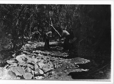
Photograph - B/W, C 1920s
Men have started to form the Mt Victory Road. Until the 1900's access to the Stoney Creek gorge was via a winding bridal jinker track. Increased traffic lead to much of this route being widened into what became known as Bluff Road. Within a few years the route was further improved and was officially named Mount Victory Road in 1930.Photo shows 3 men working with pick and shovel on roadPick and shovel Mt Victory Rdaccess routes, roads, access routes, road building -
 Brighton Historical Society
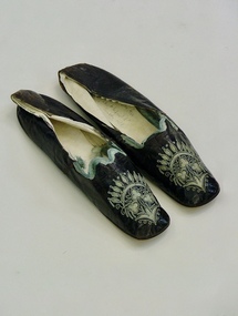
Shoes, 1850s
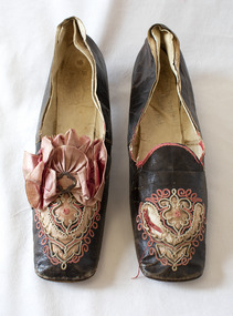
These shoes were worn by Emily Cock (nee Smith), the daughter of wealthy early settler John Matthew Smith. From 1856 until 1931 the Smiths lived at 'Castlefield', a mansion on a vast estate that at one time stretched along South Road from Bluff Road to Hampton Street. The land was gradually subdivided, and the house is now a part of Haileybury College.Pair of flat black kid leather indoor shoes decorated with pale blue silk, cut-away applique and embroidery.shoes, embroidery, applique, castlefield, emily smith, brighton -
 National Wool Museum
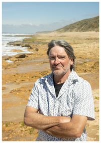
Photograph - Portrait of Jon Duthie, Nicole Marie, 2021
Thousands of volunteers work tirelessly to conserve and protect the environment of Geelong and the Bellarine. Their work often goes unnoticed. In 'The Work of Nature' the National Wool Museum and the Environment Department at the City of Greater Geelong worked with photographer Nicole Marie to showcase the significant contribution of environment volunteers in our region. Each of the eight people showcased in these portraits were nominated by their peers and members of the community for their significant contribution to conserving and protecting the environment. Jon Duthie - Friends of the Bluff Sometimes the work that volunteer groups put in to bringing back nature goes completely unnoticed. When Jon and his colleagues began work at the Barwon Bluff the site was largely devoid of any vegetation. Today most new residents and visitors to Barwon Heads don’t even know that the site is actually a revegetation site. Jon is extremely knowledgeable, dedicated and passionate and has contributed significant amounts of time to raising awareness about the marine and coastal environment. For over twenty years he has also helped to organise Festival of the Sea in Barwon Heads.Image showing an environmental portrait of a man standing on a beach with sand dunes and ocean in the background.environment, conservation, portraits, geelong, nature, exhibition, work of nature, geelong nature forum, volunteers, barwon heads -
 Orbost & District Historical Society
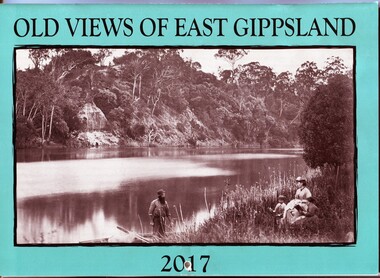
calendar, E-Gee Printers, Old Views of East Gippsland 2017, 2016
This is one of a series of calendars compiled annually by East Gippsland Historical Society.This is a useful pictorial reference tool.A 2017 stapled calendar, titled "Old Views of East Gippsland". On the turquoise coloured front is a black/white photograph of Eagle Point, Mitchell River C 1875 with a family group, possibly Alfred Howitt and children, on the bank of the Mitchell River opposite Eagle Point Bluff.. It contains early photographs of East Gippsland,. There is a hole for hanging. The title is at the top and the year at the bottom in black print. calendar-old-views-of-east-gippsland photographs-historic-east-gippsland -
 Lakes Entrance Historical Society
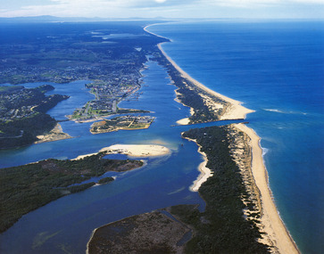
Photograph - Lakes Entrance, 1985c
Photo was cut from Tourist brochureColour photograph showing aerial view of township and the Ninety Mile Beach. Pecks factory on Bullock Island, Old North Arm bridge, bitumen for carpark for future. Fishermen's Club near North Arm Bridge. Photo shows East end of Rigby Island and Snake Island. Glimpse of Red Bluff, Lake Bunga and Lake Tyers in far east. Lakes Entrance Victoriabridges, coast, waterways, topography, township -
 Wodonga & District Historical Society Inc
Domestic object - Lady's Pen and ink set, c1920s
This pen and ink set is part of a collection donated by Mrs. Jean Raper. It was used by the teacher at Upper Gundowring Primary school, Victoria. The school, number 2733, opened on 13 July 1886. Due to changing demographics in the region, in 1953 the school was merged with schools from Dederang North, Kergunyah, Gundowring, Kiewa, Red Bluff, Charleroi and Gundowing North on a 10 acre site with 11 rooms at Kiewa to become Kiewa Valley Consolidated School.This item is from Raper Collection donated to the Wodonga Historical Society by Mrs. Jean Raper. A china pen and ink set painted with a floral design.pen and ink, personal items, teacher supplies, upper gundowring primary school -
 Glen Eira Historical Society
Document - Glen Huntly Pioneers
Two items about the fever ship Glen Huntly tragedy of 1840. A typed article from the Historical Society of St. Kilda relating to an early quarantine station at Red Bluff, now point Ormond. A document downloaded from Friends of St. Kilda Cemetery website by Margaret Dunbar dated 01/02/01, who was looking for information on Glen Huntly. The name of the fever ship was memorialized as the names of a Melbourne suburb, railway station and road.glen huntly, glen huntly road, glenhuntly station, diseases, glen huntly pioneers, ships, migrants, typhus road -
Glenelg Shire Council Cultural Collection
Print - Lithograph, Early View of Town of Portland, 1890-1905
Displayed in History House. Removed from frame and rehoused, January 2007. Previously owned by Murray Wilson, 1923-1989.Donated by Mrs Betty Wilson in memory of her husband, Murray Wilson (1923 - 1989)Lithograph of a drawing of Portland, viewed from an elevated position. Cliffs on foreground right curve towards a series of piers. To right is a church and a series of houses on blocks, with a wide street in front. Couta boats, row boats and steam ships are in the harbour, one steamship is berthed at the end of a long pier with a railway track leading from it. In background the coastline curves around the harbour, with a lighthouse evident on a bluff at upper left of image.Front: (no inscriptions) Back: Murray F. Wilson/from E. Wilson (on backing board, now removed) -
 Orbost & District Historical Society
coloured photograph
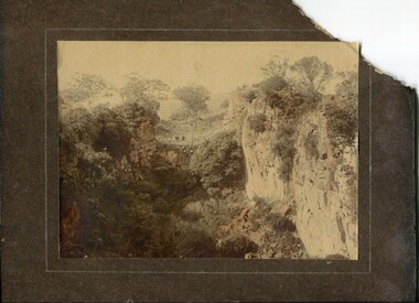
There is no information with this item. "The Pyramids", was named due to huge rocks that jut out from the hill, being shaped similarly to the Egyptian Pyramids. " Where the Murrindal River winds between high limestone bluffs before disappearing into a mountainside and becoming an underground river, four miles north-east of Buchan, is the region known as The Pyramids. It is an area of limestone caverns and sink holes overshadowed by three rock stacks. Some of the caves are the last resting places of long dead Murrindal animals." ( from MBW Walk magazine 1970 - Melbourne Bushwalkers"A hand-painted colour photograph of a view of mountain ranges with men on horses in the background.on front - "Pyramid Gorge Buchan"pyramid-gorge-buchan murrindal limestone-caves -
 Bayside Gallery - Bayside City Council Art & Heritage Collection
Work on paper - ink and watercolour, Annette Meikle, Shenval, 1977
In 1977, artist Annette Meikle undertook a commission to illustrate a book recording stories of places and people in the Bayside area. It was published in 1978 as Sandringham Sketchbook, with text by Elizabeth Waters. The sketches were intended to record remaining examples of Bayside’s early architecture and environment, as well as reflect newer architectural changes. Meikle went on to donate 22 of these sketches to Bayside City Council in 2003. Built in 1891 for Captain Murray to his own design, ‘Shenval’ originally stood on five acres fronting Bluff Road, Black Rock.Annette Meikle, Shenval 1977, ink and watercolour, 33 x 23.5 cm. Bayside City Council Art and Heritage Collection. Donated by the artist, 2003annette meikle, sandringham sketchbook, elizabeth waters, black rock, architecture, historic house, shenval, captain murray, bluff road, verandah -
 Brighton Historical Society
Shoes, circa 1867
These shoes were worn by Emily Cock (nee Smith), the daughter of wealthy early settler John Matthew Smith. From 1856 until 1931 the Smiths lived at 'Castlefield', a mansion on a vast estate that at one time stretched along South Road from Bluff Road to Hampton Street. The land was gradually subdivided, and the house is now a part of Haileybury College. Julien Mayer was a French ladies shoemaker and prolific exporter who advertised his successes on the shoes themselves by stamping the soles with details of the prizes he had won.Pair of black kid leather shoes with low block heel, decorated with pink silk, cut-away applique and embroidery. Pink bow with metal clasp on one shoe; missing from the other. Edged with pink silk ribbon binding, largely deteriorated.Sole embossed with "MAYER / Julien / à Paris", in addition to tamped with three small medallions proclaiming the awards the shoemaker won in London in 1862, Porto in 1865 and Paris in 1867. Handwritten in interior sole of T0124.2 in pencil: "Emily Smith / Castlefield"emily smith, castlefield, shoes, 1860s, applique, embroidery, julien mayer -
Glenelg Shire Council Cultural Collection
Print - Contact Print - Pastoral Scene, 1960-1979
Sheet of 4 contact prints from glass plate negatives. Top left: Stream running through bushland and beneath bridge. Top right: Dutton Way beach, looking towards south. Bottom left: Whalers Bluff with lighthouse from Dutton Way. Bottom right: 3 women sitting at small table, taking tea. Outdoor scene, ivy-clad wall behind them. They are dressed in late 19th, early 20th century fashion. -
 City of Moorabbin Historical Society (Operating the Box Cottage Museum)
Clothing - Clothing, City of Moorabbin Tie, Circa 1960s
The City of Moorabbin existed from 1934 until 1994. Henry Dendy's Special Survey in 1841 of 5,120 acres in the Parish of Moorabbin , extended from Port Phillip Bay , then East to Boundary Road, South to South Road and North to North Road and became known as Brighton. 1859 Brighton became a Borough with its boundary Thomas Street ,and Bluff Road. In 1862 The Moorabbin Roads Board was formed and the extended area now included Cheltenham, Hampton, Sandringham, Black Rock, Beaumaris, Mentone and Mordialloc .and Little Brighton became known as Bentleigh. In 1871 the area became known as The Shire of Moorabbin. Gradually the area was separated into The Borough of Sandringham 1917, ( Black Rock, Beaumaris , Sandringham and Hampton ) Borough of Mentone and Mordialloc 1920, ( Parkdale ). In 1934 The City of Moorabbin was established for the area from South East corner of Thomas Street and North Road , East to Warrigal Road, Clayton Road, Kingston Road , Lower Dandenong Road, then South along Nepean Highway to Balcombe Road and along Bluff Road, Cummins Road, Nepean Highway, Thomas Street to North Road In the 1994 Amalgamation of Councils the City of Moorabbin was divided between the new City of Kingston in the South ( from South Road) and the new City of Glen Eira to the North . It was the largest Municipality in Victoria with a population of 118,865 in 1974This tie c 1960 is a memento of the City of Moorabbin 1934 - 1994Maroon colour, polyester, man's tie with the crest of City of Moorabbin woven on front.around circle enclosing Coat of Arms ; CITY OF MOORABBIN city of moorabbin, moorabbin roads board, moorabbin, brighton, dendy's special survey 1841, early settlers, pioneers, market gardners, dendy henry, were jonathan b, cheltenham, bentleigh, mentone, sandringham, mair william, bent thomas -
 Glenelg Shire Council Cultural Collection
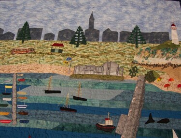
Artwork, other - Quilt, Pioneer Quilters, Millenium Quilt, 2002-2005
Portland Quilters Exhibition, 1-28 February 2006, Portland Arts Centre.Hand and machine pieced and appliqued quilt. Central depiction of the Portland bay with jettie, breakwater and Port. Scene includes fishing boats, ships, tug boats, a whale, foreshore with several buildings and a bluff with a lighthouse. Central image edged in blue fabric quilting. Surrounding this are 20 printed images of old buildings taken from sketches contained in 'The Portland of Jack Adamson' by Joe Wiltshire (book). Outside boder is blue quilted fabric. Back top contains folded and sewn area for mounting/hanging beam.Front: (no inscriptions) Back: (no inscriptions)needlework, local history, quilting -
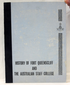 Orbost & District Historical Society
book, History of Fort Queenscliff and the Australian Staff College, December 1971
"Fort Queenscliff, in Victoria, Australia, dates from 1860 when an open battery was constructed on Shortland's Bluff to defend the entrance to Port Phillip Bay. The Fort, which underwent major redevelopment in the late 1870s and 1880s, became the headquarters for an extensive chain of forts around Port Phillip Heads. Its garrison included volunteer artillery, engineers, infantry and naval militia, and it was manned as a coastal defence installation continuously from 1883 to 1946. The other fortifications and armaments around the Heads were completed by 1891, and together made Port Phillip one of the most heavily defended harbours in the British Empire." (from Fort Queenscliff History website)This is a useful reference tool.A light blue covered book, titled, "History of Fort Queenscliff and the Australian Staff College". It has a daker blue spine and black print.fort-queenscliff cunningham-c.a. -
 Melbourne Tram Museum
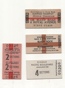
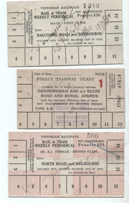
Ephemera - Sandringham - rail - tram - bus tickets - set of 4, Victorian Railways (VR), 1950s to 1980s
The Victorian Railways continued to operate a bus service along the former Black Rock - Sandringham line, long after the tram line closed. This set of tickets represents samples of Edmondson-style tickets sold at stations for use on the bus. 1 - Middle Brighton to Cnr of Bluff Road & Royal Ave - first class - joint rail and tram tickets - No. 0128 - dated stamped 15 June 1971 (this ticket was purchased by the donor as a sample at the time) 2 - Weekly ticket - Black Rock and Elsternwick - issued at Sandrinham - No. 0809 3 - Single ticket - 4 sections - Pacific Boulevard - No. 05208 4 - Return ticket - 2 sections - day return - Pacific Boulevard - No, 00826 Demonstrates a railway ticketting system that was used on buses and railwaysSet of 4 Edmondson style railway tickets.railways, tickets, weekly tickets, buses, victorian railways, sandringham, sandringham to black rock, pacific boulevard -
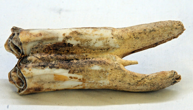 Orbost & District Historical Society
tooth
This was dug up at the old station at Lochend owned by the Stirling family and abandoned in the early 1870's. James Stirling's son Thomas Telfer Stirling took up the Corringle Run stretching from Lake Tyers along the coast. The home was at the Old Station. When he moved to Bruthen, James Stirling took over the Corringle Station. He is buried in the Marlo cemetery. He built a bark hut on the bluff that had two rooms, bark walls, earthen floors and a shingle roof. By 1884, this structure had expanded to a 9 roomed accommodation house and in 1886 became the Marlo Hotel when a liquor license was granted. info. from Personalities and Stories of the Early Orbost District by Mary Gilbert. The first settler to occupy the Marlo township area was James Stirling around the year 1875.An old horse tooth. Probably from before 1920. It is a molar.tooth stirling molar equine -
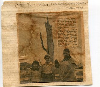 Kiewa Valley Historical Society
Newspaper clipping 11/7/72 Canoe tree in Kiewa & Photo-Tawonga Homestead
1. Kiewa Valley Consolidated School was established in 1953 combining Dederang North, Kergunyah, Gundowring, Kiewa, Gundowring Upper, Red Bluff, Charleroi and Gundowing North schools on a 10 acre site with 11 rooms at Kiewa. The bark was cut from the canoe tree, by aboriginal craftsmen, to produce a canoe for fishing in the rivers running through the Kiewa Valley either before or just after the 1800's. The tree trunk, located at Kiewa, would have been used at the beginning of European settlement in the Kiewa Valley or just before contact was made. 2. Pictorial record of the graves of early pioneers C Ibbotson, Mrs Elizabeth Eyre and John Eyre who died between 1858 – 1904, all located at Tawonga Homestead 1. The above schools are in the Kiewa Valley. The date and number of combined schools give insight into the change in population and families in the Kiewa Valley before and after 1953. The tree was found along the Kiewa River and indicates that Aborigines lived by the river and used tree bark to craft canoes to cross rivers and to fish in the deeper sections of the river. 2. Pictorial record of the early history of Kiewa Valley pioneers whose descendants have lived and worked in the Kiewa Valley for many years 1. Newspaper article of local school children visiting a canoe tree in Kiewa July 11, 1972. mounted on buff card 2. Black and white photo of pioneer graves at old Tawonga Homestead. Mounted on buff card 1. Handwritten in black ink above newspaper clipping ‘Canoe Tree Kiewa Valley Consolidated School. 11 July, 1972’ Handwritten in pencil at bottom of article ’10 Nov. ‘72’ 2. Handwritten in black ink above photo ‘Tawonga Homestead graves’ Handwritten below photo ‘T Ibbotson D. 1858, Elizabeth Eyre D. 1879, John Eyre D 1879, John Eyre D. 1904 tawonga homestead, canoe tree at kiewa, tawonga graves -
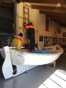 Queenscliffe Maritime Museum
Vehicle - Workboat ex Wyuna
In 1974, this 18 foot (5.5 meter) diesel-powered workboat was one of the last boats built to operate from the pilot cutter Wyuna. These boats were used to transfer pilots from the Wyuna to the ship being serviced or vice versa. Until 1946 they were propelled by two oars then simplex two-stroke petrol engines were fitted followed by diesel engines. The Pilot Service Shipwrights built the boats in a shed which stood on the site of the present Pilot Station, Tobin Drive, North of Shortland Bluff. The design is based on a Gig and was developed by the Pilots as suitable for the severe conditions at the entrance to Port Phillip. To understand how these boats were used view the film "Through The Rip" on the video in the Exhibition Hall.Close association with QueenscliffTimber Workboat used to transfer pilots between Wyuna and ship requiring servicepilot service, wyuna, workboat, boat buiding, port phillip sea piots -
 Melbourne Tram Museum
Ephemera - Rail & Tram weekly tickets, Victorian Railways (VR), c1935
Set of three Victorian Railways Rail & Tram weekly Periodicals with conditions of travel on the rear, See reference page 124 and Figure 6-27. Such tickets were introduced on 1/7/1939. All tickets were available for 14 tram trips only, but unlimited rail trips: 1 - Balcombe Road and Melbourne - First Class - white card - No. 1346, marked cancelled 13/5/1939 2 - Sandringham and cnr Bluff Road and Royal Ave - white card - Male, No. 41618, price 1/3 with a red 1 (first class?) - stamped cancelled 3 - North Road and Melbourne - white card overprinted in pink to leave a cross, Female, No. 506, Second class, with cancelled hand written on the front.Demonstrates a Victorian Railways Rail and Tram weekly tickets for both their tramways and the changes made over time. May have been used for training samples.Set of three printed card tickets with over printing and hand writing as shown.tickets, vr, vr trams, victorian railways, st kilda brighton tramway, weekly tickets, sandringham to black rock -
Glenelg Shire Council Cultural Collection
Photograph - Sheet of 12 contact prints - Various historic Portland buildings and Landmarks, c. 1970
Sheet of 12 contact prints of rephotographed photographs. Identifying numbers 5724 a, b, c, d, e, f, g, h, i, j, k, l (a) First jetty and immigration depot (b) National School (c) Observatory Hill (d) 'Kenley" Res. George Crouch, First Post Master (e) Old Library (f) Union (ANZ) Bank (g) Lighthouse and Keepers Cottage (h) 'Blainslie' (i) View from Whalers Bluff over Bay (j) Percy Street, view from Henty Street (k) Portland Jail (l) Flagstaff and Light Keepers quartersFront: (a) Henty Beach (b) Portland State School (c) Old Library (f) ANZ Bank (i) View of Whalers Point (k) Portland Jail on Observatory Hill -
Glenelg Shire Council Cultural Collection
Photograph - Sheet of 12 contact prints - Various historic Portland buildings and Landmarks, c. 1970
Sheet of 12 contact prints of rephotographed photographs. Identifying number 5717 a, b, c, d, e, f, g, h, i, j, k, l (a) Nun's Beach with boats (b) 3rd Baths (c) Percy Street West, view from Henty Street (d) Percy Street, west, further along Street (e) Habrour from Whalers Bluff (f) Portland Gaol (g) Flagstaff and Lightkeepers Quarters, Observatory Hill (h) Claremont (i) First Portland Post Office building (j) Res Abraham Barrett, baker (k) Warehouses Trangmar & Crouch (l) Union Bank -
Glenelg Shire Council Cultural Collection
Photograph - Contact Print - Scenes of Portland, Victoria, 1970s
Sheet of 12 contact prints of rephotographed photographs: (a) 5 young women on dam wall (b) sailors (c) Bentinck Street, looking north from Post Office (d) Julia Street looking east from Percy Street (e) Railway line and Duttons (Nuns) Beach towards Whalers Bluff (f) Fawthrop Lagoon (g) sailors (h) Post Office (i) River, bush close to banks both sides (j) Botanic Gardens (k) Town and Port of Portland reproduced from III London News (l) North side, Julia Street looking west, Bank AustralasiaFront: (c) Bentinck Street approx. 1900 (d) Julia Street, portland Nicholls (h) Portland Post Officeportland scene, street scene, photography, portland harbour, portland seafront, julia street -
 St Kilda Historical Society
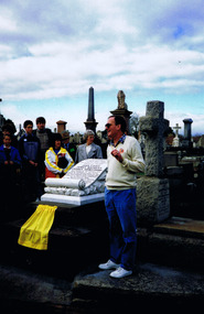
Photograph, 'Glen Huntley' Passengers Memorial Restoration 1992 - images collection, 1992
The memorial grave was dedicated on 16 April, 1899. Following the 150th anniversary of the arrival of the barque, descendants of John Craig and other "Glen Huntly" passengers restored the memorial. Descendants gathered in 1992 for the unveiling of a plaque marking the restoration.Colour photographRear of each photograph: SK Cemetery 1992 Glenhuntly Descendants. Inscription on memorial: On December 13th 1839, the emigrant ship "Glen Huntly" left Greenock, Scotland and arrived in Hobson`s Bay on 17th April 1840. Many of the passengers suffering from fever were landed at the Red Bluff St Kilda on 24th April 1849. That being the first quarantine station in Victoria. A few days later John Craig James Mathers George Armstrong succumbed to the disease and were interred at The Bluff. Owing to the encroachment of the sea their remains were exhumed and removed to the St Kilda Cemetery on 27th August 1898 by the Board of Public Health.This memorial was erected by public subscription, to mark a notable event in the early history of the colony. Inscription on plaque, unveiled in 1992: This memorial grave was restored by descendants of John Craig and of other "Glen Huntly" passengers. In April 1990 they commemorated the 150th anniversary of the arrival of the barque in Melbourne in 1840. 25th August 1991st kilda cemetery, glen huntly, john craig, james mathers, george armstrong, 1992, glen huntley -
 Wodonga & District Historical Society Inc
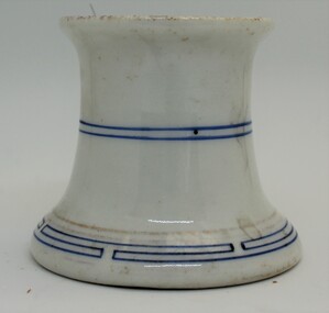
Domestic object - Ceramic ink pen cleaner, 1900 - 1920s
Pen-wipers or pen-cleaners were invented to prolong the usefulness of their pens by keeping them clean and dry between uses. This helped to prevent rusting of the nib from water-based inks. In the 1890s and 1900s, with the rise of the fountain pen, pen-cleaners remained a popular desktop accessory, since they could still be used to wipe away the excess ink from the nib and feed of a pen, once it had been refilled in an inkwell. Pen-cleaners died out in the second half of the 1900s when people started using ballpoint pens. This wiper was used by the teacher at Upper Gundowring Primary school, Victoria. The school, number 2733, opened on 13 July 1886. Due to changing demographics in the region, in 1953 the school was merged with schools from Dederang North, Kergunyah, Gundowring, Kiewa, Red Bluff, Charleroi and Gundowing North on a 10 acre site with 11 rooms at Kiewa to become Kiewa Valley Consolidated School.This item is was donated by Mrs. Betty Barberis, a well-known artist in the Wodonga district.ThIs ceramic pen wiper/ cleaner was produced to clean and maintain the nib on an ink pen. It has a blue line pattern at the base, middle and inside the rim.domestic items, writing implements, pen and ink -
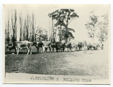 Orbost & District Historical Society
black and white photograph, late 19th century - early 20th century
Aged 19 James Stirling arrived in Melbourne on January 26, 1842 with his family - parents, three sisters and two brothers. James Stirling moved around a lot to Whittlesea, Ballarat goldfields, Cunninghame, (now Lakes Entrance), then to the Old Station about 36 miles to the east along the coast near the mouth of the Snowy River and for a time settled there with his wife also from Wigton, Scotland, and their family four sons two daughters (James, John, William, George, Margaret and Polly). The first settler to occupy the Marlo township area was James Stirling around the year 1875. He built a bark hut on the bluff that had two rooms, bark walls, earthen floors and a shingle roof. By 1884, this structure had expanded to a 9 roomed accommodation house and in 1886 became the Marlo Hotel when a liquor license was granted. (more information from “Snowy River Mail”, Wednesday, April 13th 1977: MEMORIES OF MARLO by Mrs Elsbeth Conlon (nee Stirling ) During the 19th century bullock teams were the most effective means of transporting people and goods inland, as the roads were badly made and in poor condition. The better roads were closer to the towns, and the further away from the town, the worse the conditions of the roads. Bullock teams drew heavily laden carts full of provisions, equipment and people from town to town and into the countryside to isolated homes. This item is associated with that era. It is also associated with James Sterling a very early settler of Marlo.A black / white photograph of a bullock team with a man standing beside it.on front - J STIRLING S BULLOCK TEAMstirling-james marlo-history bullock-team transport -
Glenelg Shire Council Cultural Collection
Souvenir - Tea Towel - Maretimo, Portland, n.d
From the National Trust register: Statement of Significance Maretimo, a 22 room single storey Australian Colonial Georgian style mansion set on a prominent bluff overlooking Portland harbour, was erected c. 1854 for John Norman McLeod. The design of Maretimo, which is constructed of basalt ashlar with fine-axed parapet entablature, delicate open timber work verandah and Regency interior, has been tenuously attributed to Adelaide architect James Barrow. Maretimo is rivalled only by the stylistically similar Henty residence, Burwsood of 1853 by James Barrow, as perhaps the finest Australian Colonial Georgian style residence erected within the first twenty years of settlement in Victoria. The residence, which was occupied for twenty years by distinguished English-born gentleman parliamentarian, pastoralist and former Van Deimen's Land settler, J H McLeod, is now notable for the disciplined facade and elegantly crafted interiors. Maretimo has been meticulously maintained and is presented in near perfect original condition. The interiors have been sensitively enhanced and redecorated.Linen souvenir tea towel 'Maretimo'. Green and black on cream. 'MARETIMO' at top, front view of Maretimo beneath, then map of locaion, then view from air. 'HISTORIC HOME PORTLAND, VICTORIA' beneath 'Pure Linen', bottom right.historic building, historic homestead, maretimo, henty, souvenir -
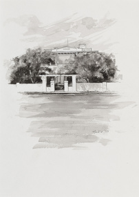 Bayside Gallery - Bayside City Council Art & Heritage Collection
Work on paper - ink and watercolour, Annette Meikle, Karinga, 1977
In 1977, artist Annette Meikle undertook a commission to illustrate a book recording stories of places and people in the Bayside area. It was published in 1978 as Sandringham Sketchbook, with text by Elizabeth Waters. The sketches were intended to record remaining examples of Bayside’s early architecture and environment, as well as reflect newer architectural changes. Meikle went on to donate 22 of these sketches to Bayside City Council in 2003. This inter-war house located at 60 Bluff Road, Black Rock, was built in 1926 for former Scotland Yard and Criminal Investigation Branch detective Horatio Reginald Clarence McWilliams. When McWilliams died it was found that he had taken extreme measures to protect his security. All the windows were nailed shut, a network of burglar alarms ran through the house and a complicated underground air raid shelter had been built in the garden. The security measures were at odds with the name of the house – Karinga or Karinya – an Aboriginal word meaning peaceful, happy home. Later residents of ‘Karinga’ included Senator Don Chipp and his family. The property has since been demolished and apartments have been built on the land.Annette Meikle, Karinga 1977, ink and watercolour, 32 x 23.5 cm. Bayside City Council Art and Heritage Collection. Donated by the artist, 2003annette meikle, sandringham sketchbook, elizabeth waters, black rock, karinga, karinya, horatio reginald clarence mcwilliams, senator don chipp, historic house, bluff road -
 Ballarat Heritage Services
Photograph - Photograph - Colour, Clare Gervasoni, Fort Queenscliff, 2015, 15/03/2015
Fort Queenscliff was established in 1860 when an open battery was constructed on Shortland's Bluff to defend the Port Phillip Bay entrance. The Fort, which underwent major redevelopment in the late 1870s and 1880s, became the headquarters for an extensive chain of forts around Port Phillip Heads. Its garrison included volunteer artillery, engineers, infantry and naval militia, and it was manned as a coastal defence installation continuously from 1883 to 1946. The other fortifications and armaments around the Heads were completed by 1891, and together made Port Phillip one of the most heavily defended harbours in the British Empire. It is claimed that the first British Empire artillery shots of World War One were fired when a gun at Fort Nepean fired across the bow of the German freighter Pfalz, as she was attempting to escape to sea. The orders to fire came from Fort Queenscliff. It is alleged that the same gun, with a different barrel, also fired the first Australian artillery shot of World War II. By 1946 coastal artillery was outmoded, and the Fort became home of Army's Staff College. After the three Service Staff Colleges were combined in Canberra, it became the base for Army's Soldier Career Management Agency in 2001.Colour panoramic photograph of Fort Queenscliffqueenscliff, fort queenscliff, army, volunteer forces -
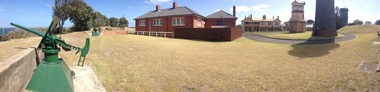 Ballarat Heritage Services
Photograph - Photograph - Colour, Fort Queenscliff, 2015, 15/03/2015
Fort Queenscliff was established in 1860 when an open battery was constructed on Shortland's Bluff to defend the Port Phillip Bay entrance. The Fort, which underwent major redevelopment in the late 1870s and 1880s, became the headquarters for an extensive chain of forts around Port Phillip Heads. Its garrison included volunteer artillery, engineers, infantry and naval militia, and it was manned as a coastal defence installation continuously from 1883 to 1946. The other fortifications and armaments around the Heads were completed by 1891, and together made Port Phillip one of the most heavily defended harbours in the British Empire. It is claimed that the first British Empire artillery shots of World War One were fired when a gun at Fort Nepean fired across the bow of the German freighter Pfalz, as she was attempting to escape to sea. The orders to fire came from Fort Queenscliff. It is alleged that the same gun, with a different barrel, also fired the first Australian artillery shot of World War II. By 1946 coastal artillery was outmoded, and the Fort became home of Army's Staff College. After the three Service Staff Colleges were combined in Canberra, it became the base for Army's Soldier Career Management Agency in 2001.Colour panoramic photograph of Fort Queenscliffqueenscliff, fort queenscliff, army, volunteer forces