Showing 1071 items matching "campus plans"
-
 Federation University Historical Collection
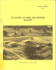
Book, Ballarat School of Mines Annual Report, 1971, 1971
The President in 1971 was M.B. JohnYellow soft covered, stapled annual report with an image of the first building on the Mount Helen campus. Contents include: E.A. Bald, Centenary Medallion, Centenary medal, Greenhalgh, Stokes and Son, Centenary Booklet, plaques, opening of the Mount Helen Campus, Centenary appeal, Mt Helen Master Plan, Metallurgy, fourth University Enquiry,bald, biddington, olive rattray, andrew berry, harrison, greenhalgh, annual report -
 Federation University Historical Collection
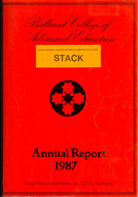
Book, Ballarat College of Advanced Education Annual Report, 1987, 1987
Ian Gordon was the Ballarat College of Advanced Education President in 1988. Orange soft covered annual report. Contents include: Financial Statement, Retirement of Lindsay Hillman, E.J. Barker, Adrian Thomas, Henry Moritz, Brian Lees, Isobel Dowling, Marney Poole, Keith Davison; Staff appointments, Allan Mann, Adrian Mauriks, John Crowe, Max Brooke, Gayle Richards, Kaye Arnel, Ron Keno, George Fong, Berverley Taylor, Alan Donelly, Krystina Antosiewicz, Donna Tiller, Dorothy Lea, Barbara Trudinger, Duc Thac, Susan Parks, Janice Newton, Angus McLachlan, Peter Kirkpatrick, Digma Magsino-Tjoe, Julie King, Mary Walker, Gerry Bushnell, Malcolm Dorricott; Staff obituary, Ron Shaw; Urban Koala Project (Pat Prevett). The Human Studies Building was opened (Architect: Ewan Jones & Associates ), PABX installed, plans were developed for a Creche on campusballarat college of advanced education, bcae, mt helen, mount helen, hillman, barker, prevatt, koalas, barry jones, -
 Federation University Historical Collection
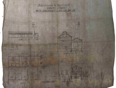
Plan, Ballarat Jam Factory, Davey Street, not dated
Plan for the Ballarat Jam Factory, Davey StreetAdditions to Factory Davey Stret for the Ballarat Jam Coy Pty Ltdballarat jam factory, grigsby, industrial heritage, davey street -
 Federation University Historical Collection
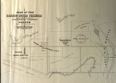
Plan, Plan of the Haddon United Freehold
Plan of the Haddon United Freehold. Scale: 15 chains to 1 inch (1:11,880) WGS 84 Centroid Lat: 37 degrees 35' 04" S Long: 143 degrees 40' 52" E NS: 2.8 km EW: 5.4 kmhaddon, plan, haddon united, haddon freehold, haddon race course co, haddon racecourse co, haddon united freehold, reform gold mining company -
 Federation University Historical Collection
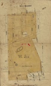
Plan, Ballaarat No 5722, 28/11/1903
... cgt plans phoenix p-12 school senior campus Plan ...Part of the block shaded yellow on the plan contains Phoenix P-12 School Senior CampusPlan of Ballarat with leae area No 5722 coloured yellow. Plan of the streets around Hertford Street, ballarat. The yellow depicts the area leased (No 5722 Ballarat)mining lease 5722 ballarat, ballarat, hertford street, cromwell street, alexandra street, alfred street, verdon street, clarkson street, spencer street, franklin street, hill street, grant street, albion street, rowlands street, edwards street north, mining, cgt, plans, phoenix p-12 school senior campus -
 Federation University Historical Collection
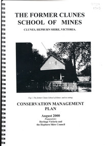
Book, The Former School of Mines Clunes Conservation Management Plan, 2000, 08/2000
The Clunes School of Mines was a campus of the Ballarat School of Mines. The conservation plan was prepared for Hepburn Shire Council and Heritage Victoria to guide the future management of the former Clunes School of Mines in Service Street, Clunes, The building was opened in February 1892 as the Clunes branch of the Ballarat School of Mines, and ceased operating in June 1893.Spiral bound black and white copy of the Conservation Plan for the Clunes School of Mines. Contents include the history, chronology development, context of the building and site, current and past function of the building, original fabric, impact of later alterations, condition of the building, statement of significance, conservation action plan, caring for the site, collecting and keeping information, structural engineers Report, Department of Lands Survey 1955, Memorandum of Agreement 1956.ballarat school of mines, clunes school of mines, australian native association, ana, australian native association clunes branch, eygelaar inner spring mattress factory, clunes infant welfare centre, clunes angling club -
 Federation University Historical Collection
Book, Camp Street Precinct Ballarat Conservation Management Plan (Draft), 1999, 10/1999
The conservation management plan was commissioned by the City of Ballarat to assist in the process of planning for the future management and development of the Camp Street precinct, having particular regard for the Camp Street Arts and Education Precinct.White, soft covered, spiral bound book relating to Ballarat's Camp Street Precinct. Contents include: Methodology, buildings and site layout. ballarat, camp street, clare gervasoni, ballarat fine art gallery, art gallery of ballarat, old colonists' hall, former ballarat mining exchange, former state offices, former police court, former police station, former police barracks, old police station, arts academy, archaeology, conservation management plan -
 Federation University Historical Collection
Plan - Plan (copy), Melbourne Road Ballaarat, 1857
This map shows the vicinity of the site of the Eureka Stockade. A3 black and whole photocopy of a plan of Ballarat's Melbourne Road. The plan shows Melbourne Road, Proposed Melbourne Road (later Eureka Street), Chamberlain Street, Queen Street, Allotments between Rodier Street and Stawell Street (William Collard Smith, J & T Oddie, F.A. Edward A. Wynne, David Fitzpatrick, Robert Walsh, Charles Spencer, Alfred Lester, Free Trade Hotel)william collard smith, oddie, wynne, fitzpatrick, walsh, spencer, lester, free trade hotel -
 Federation University Historical Collection
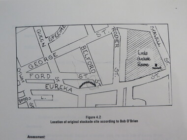
Report, Concept Study for the Further Development of the Eureka Stockade Reserve Conservation Plan, Vol 3, c1992
The objectives of the study were to * gather historical data and confirm the cultural significance of the site and reserve. * review existing site conditions including ownership together with current and proposed land uses. * Eureka Stockade location Copy of a 38 page report called "Concept Study for the Further Development of the Eureka Stockade Reserve Conservation Plan Vol 3", published by Ballarat University College. Authors are not stated. eureka, eureka stockade, ballarat university college, bert strange, bob o'brien, weston bate, alec barnett, jack chisholm, lloyd jenkins, eureka stockade location, cultural significance, eureka stockade site -
 Federation University Historical Collection
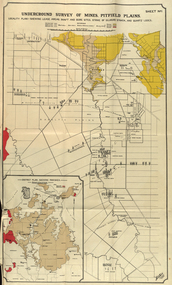
Book, Stanley B. Hunter, Report on the Pitfield Plans Gold-Field, 1901, 1901
Blue soft covered foolscap report with 15 plans and sections.pitfield, gold, mining, geology, pitfield plains, british banner, pitfield plateau, pitfield quartz and cement, woady-yalloak, queen of the plans, glenfine -
 Federation University Historical Collection
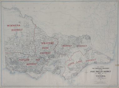
Plan, Map Showing the Pastoral Holdings of the Port Phillip District 1835-1851 Now Victoria, 1932, 1932
Another name for Pastoral Holdings is squatting runs. Information on Alfred Stephen Kenyon of the Historical Society of Victoria can be found at http://adb.anu.edu.au/biography/kenyon-alfred-stephen-6936/text12035 Map of Victoria showing the boundaries of the Port Phillip District (Victoria) pastoral boundaries. pastoral holdings, squatters, squatting, victoria, land, crown lands, a.s. kenyon, alfred stephen kenyon -
Federation University Historical Collection
Plan (copy), Frederick Proeschel, Map of the Roads to all the Gold Mines in Victoria, 1853
The map was pirated from Frederick Proeschel's "Pocket Map of the Roads to all the Gold Mines in Victoria" issued earlier in 1853.Digital file of the Map of the Roads to all the Gold Mines in Victoria. The map has been coloured to show routes to the Victorian goldfields from Melbourne and Geelong.frederick proeschel, proeschel, gold, mining, philp -
 Federation University Historical Collection
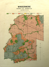
Map, Windermere, County of Grenville
Coloured geological map of Windermere, County of Grenville. Scale is 40 chains to 1 inchwindermere, grenville, krause, plan, map -
Federation University Historical Collection
Photograph - Black and White, Ballarat Courier, John Shiells and Steve Crabb
Peter Shiell (left) and Steve Crabb with plans at the Ballarat School of Minesballarat school of mines, peter shiells, shiells, steve crabb, crabb -
 Federation University Historical Collection
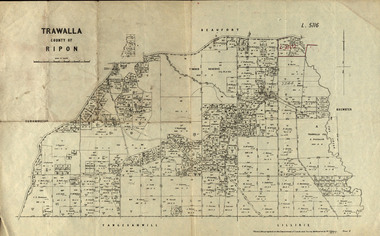
Parish Plan, Parish Plan of Trawalla in the Parish of Rippon, 1913, 28/4/1913
Trawalla is surrounded by Beaufort, Brewster, Lillirie, Yangerahwill and Eurambee.Parish Plan of Trawalla in the Parish of Rippon. trawala, ripon, westbrok, simson, mackenzie, mcarthur, wilson, nicholason, gibb, read, hayward, topper, foreman, bell, mcmillan, halpin, davis, goldsmith, trawalla pre-emptive right, butson, w.j. butson, m4471, w. read, c.a. foreman, j. simson, a. goldsmith, trawalla, g. topper -
 Federation University Historical Collection
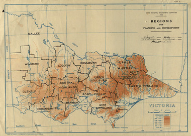
Map, Victoria: Regions for Planning and Development, 1944, 1944
This map was produced for the State Regional Boundaries Committee Two colour map of Victoria showing the regions for planning and development. The regions are Central Highlands, Mallee, Wimmera, Glenelg, Corangamite, Barwon, Loddon, Goulburn, Upper Goulburn, Upper Murray, East Gippsland, West Gippsland, Port Phillip.central highlands, mallee, wimmera, glenelg, corangamite, barwon, loddon, goulburn, upper goulburn, upper murray, east gippsland, west gippsland, port phillip, victoria, m4486 -
 Federation University Historical Collection
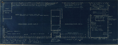
Plan, New Workshop Block Ballarat School of Mines
It is not known which building these plans belong to. Since there is a Heat Treatment Room and a number of vices it may be a metalwork room, and may be related to Repatriation classes after World War One. Blueprint of plans for a new workshop at the Ballarat School of Mines. The plan includes a lecture room, bulk store, tool store, heat treatment room, office and two machine shops. Around the machine shops are work benches and vyces (sic)new workshop block, ballarat school of mines, repatriation, buildings -
 Federation University Historical Collection
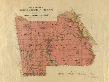
Plan, Bungaree and Dean Parish and Geological Plan, 1890, 07/1890
Ferdinand M. Krause was a Professor at the Ballarat School of Mines.Geological and Parish Map of parts of the Parishes of Bungaree and Dean in the Counties of Talbot, Grenville and Grant. The scale is 40 chains to one inch. bungaree, deen, krause, f.m. krause, musk creek, clarkes hill, badger hill, beale's reservoir, acquainted. -
 Federation University Historical Collection
Map, Municipality of Ballarat East, 1857
Gold was discovered in Ballarat in 1851. This plan was created six years later and names some of the great gold locations of Ballarat East. It also shows the locality of the Eureka Stockade (1854) and the walking tracks and roads on the Ballarat East Goldfield.In 2007 this map was listed on the inaugural Ballarat Treasure's Register.Large map backed onto linen. The map has read and blue highlights, and identifies areas such as Mount Pleasant, Golden Point, White Flat, Nightingale, Malekoff, Old Post Office Hill, Red streak, Gumtree Flat, Old Gravelpits, Bakery Hill, Ballaarat Flat, The Camp, Specimen Gully, Pennyweight Hill, Warrenheip Gully, Gays Gully, Pennyweight Flat, Eureka, Black Hill, Pinchgut, Crocodile, Hit or Miss, Little Bendigo, Brown Hill, Mopoke, Cricket Reserve, Canadian Hotel, Ballarat Eastmount pleasant, golden point, white flat, nightingale, malekoff, old post office hill, red streak, gumtree flat, old gravelpits, bakery hill, ballaarat flat, the camp, specimen gully, pennyweight hill, warrenheip gully, gays gully, pennyweight flat, eureka, black hill, pinchgut, crocodile, hit or miss, little bendigo, brown hill, mopoke, cricket reserve, canadian hotel, ballarat eastm phillips, john phillips, field draughtsman, ballarat east, ballarat east map -
Federation University Historical Collection
Booklet, Meredith Fletcher, Alumni 2002, 2002
Federation University Australia was established on 1 January 2014. Formerly known as the University of Ballarat, its enabling legislation was the University of Ballarat Amendment (Federation University Australia) Act 2013. On 1 January 2014, the University of Ballarat amalgamated with the Monash University Gippsland Campus to form Federation University Australia. The Gippsland Campus also had a long lineage dating back to 1928 with the establishment of the Yallourn Technical School which became a predecessor institution to the Gippsland College of Advanced Education formed in 1968. In 1990, it was renamed the Monash University College and in 1993 became the Gippsland Campus of Monash University. In 2016, Federation University Australia announced plans to take possession, over a two-year period, of Monash’s Berwick Campus in the south-east corridor of Melbourne. Federation University Australia, or FedUni, is headquartered in Ballarat and offers programs in Higher Education and Vocational Education and Training to regional Victoria and beyond. The University’s commitment to educational and social equity, teaching excellence, research distinction, environmental sustainability and regional capacity building has enabled it to develop in a way that draws on its proud heritage to inform its future. Its regional character sets a framework for the University’s priorities but does not constrain it from serving wider community interests, nationally and internationally. The name Federation University Australia was chosen to convey the scope and capacity of an expanded regional university with a federated network of campuses. History of the Gippsland Campus of Federation University located at Churchill.gippsland history, yallourn technical school, brian mckenzie, latrobe valley, gippsland institute of advanced education, monash university gippsland campus, yallourn, sec, peter farago, churchill campus, gippsland campus, binishell, tom kennedy, meredith fletcher, loy yang power station, yallourn open cut, yallourn power station, r.d. dixon, howard beanland, yallourn w. power station, dante bini, bini shell, sculpture, churchill, gippsland campus collection -
 Federation University Historical Collection
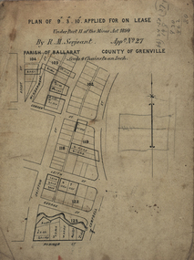
Plan, Lease Applied for by R.M. Serjeant, c1890, c1890
Plan of a lease showing streets around Skipton and Windermere Streets, Redan. Scale 4 chains to 1 inch (!:3168)serjeant, r.m.serjeant, robert m. serjeant, george street, skiptn street, windermere stret, rubicon stret, cobdon street, ascot street, lease, redan, ballarat, robert malachi serjeant, band of hope and albion mine -
 Federation University Historical Collection
Book, Mount Helen Campus Development Plan, 1970, 1970
... Mount Helen Campus Development Plan, 1970...campus plan... campus plan ballarat school of mines and industries Green covered ...The Ballarat School of Mines is the oldest site of technical education in Australia, and is a predecessor institution of Federation University Australia. The Mount Helen campus was originally the tertiary division of the Ballarat School of Mines until 1976. Green covered printed book.mount helen, ballarat institute of advanced education, mount helen campus, harrison, h.j. harrison, vernon, l.h. vernon, j.b. vernon, architecture, campus plan, ballarat school of mines and industries -
 Federation University Historical Collection
Documents, J.H. Brown, Ballarat School of Mines Cyanide Plant and Caretaker's Cottage, 1914
The Ballarat School of Mines building along Albert Street were moved or demolished to make way for the new Engineering Workshop. William Henry Middleton was President of the Ballarat School of Mines from 1912 to 1940.Particulars for removal of the Ballarat School of Mines Caretaker's Quarters and Cyanide buildings are handwritten onto a foolscap page (.1). Three plans are hand-drawn in pencil, these are: (.2) Cyanide Building (.3) Caretaker's Quarters (.4) Caretaker's Quarters - South End Elevationballarat school of mines, new engineering workshop, j.h. brown, william middleton -
Federation University Historical Collection
Booklet, Ballarat School of Mines, Ballarat School Of Mines Agenda for meeting with Chairman of the TAFE Board, 07/1985
Yellow covered A$ booklet bound with plastic. The book as in agenda for a meeting with I. Predl, acting Chairman of the TAFE Board. Items for discussion were: * L.F.J. Hillman Recreation Building * Maintenance of Buildings * Campus titles and future development * Quality Improvements * College Management Study * Uncertainties Re Blackburn The booklet also includes an aerial photograph of the Ballarat School of Mines campus, including dates each building was erected. The image shows the site of the newly demolished Ballarat Gao, and still has a tennis court and Mining laboratory onsite. The book also show allotment plans of the Ballarat School of Mines site. -
 Federation University Historical Collection
Plan, Haddon, County of Grenville, 1932, 13/04/1932
The Haddon Parish Plan shows crown parcels government roads, Crown Reserves, Railway. Scale 40 chains to 1" (1:31, 680) WGS 84 Centroid Lat: 37 degrees 34' 00" S Long: 148 degrees 40' 20" E N.S. 9.3km E.W.: 16.1kmhaddon, grenville, cardigan, water supply reserve, nentingbook pre-emptive right, a. mclachlan, lake burrumbeet, e.a. wynne, p. russell, b. hepburn, benjamin hepburn, nentingbool, t.c. wilson, j. amoy, william collard smith, james roach, j. mitchell -
 Federation University Historical Collection
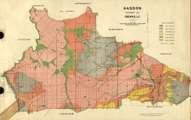
Plan, Haddon, County of Grenville, 1887, 1889
Ferdinand Krause taught at the Ballarat School of MinesGeological Map of Haddon in the County of Grenville surveyed by Ferdinand Krause. haddon, grenville, krause, ferdinand krause, cgt, lake burrumbeet, windermere, chepstowe, bailies creek, snake valley lead, nentingbool preemptice right, cardigan state forest, haddon state forest -
 Federation University Historical Collection
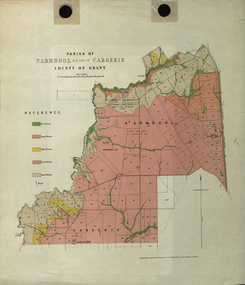
Plan - Map, Mines Department, Parish of Narmbool and part of Cargerie, County of Grant, 1892, 06/1992
This map shows the position of the homestead on the Narmbool Pre-emptive Right, volcanic craters, stock reserve, quarry and geological eras,Geological map showing Narmbool and part of Cargerie in the County of Grant in five colours, predominantly pink.narmbool, cargerie, narmbool pre-emptive right, williamson's creek, leigh river, green hill, collyer's hill, volcano, crater, krause, ferdinand krause -
 Federation University Historical Collection
Plan, Ballarat Goldfields Geological Survey, 1981
Large coloured plan showing streets, leads, geological zones and shafts. Source 1:10,000ballarat, gold, goldfield, geology, sebastopol -
 Federation University Historical Collection
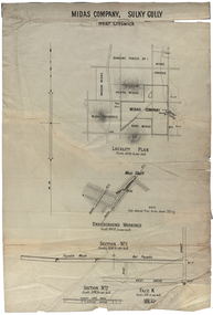
Plan, Midas Company, Sulky Gully near Creswick
Locality and Underground Workings plan for the Midas Company, Sulky Gully near Creswick. Companies shown on the Locality Plan include Dowling Forest No 1., Midas Consols, Madam Midas, Midas Company, King Midas and Midas Extended.dowling forest no 1., midas consols, madam midas, midas company, king midas, sulky gully, creswick, midas extended, cgt -
 Federation University Historical Collection
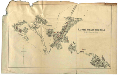
Plan, Haunted Stream Gold Field
Plan of the Haunted Stream Gold Field - scale 16 chains to 1 inchhaunted stream, plan, battery