Showing 257 items
matching concrete bridge
-
 Phillip Island and District Historical Society Inc.
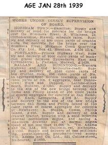
Newspaper clippings, 28/01/1939
Newspaper clippingContract to supply of aggregate for concrete to the site of the new bridge at Phillip islandlocal history, documents, newspapers, bridges, phillip island, black & white newspaper clipping, phillip island. -
 Phillip Island and District Historical Society Inc.
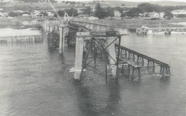
Photograph, Phillip Island Bridge, 1968/9
1969 2nd Phillip Island Bridge under construction. Suspension Bridge demolished early 1970 From the Jack Jenner CollectionConcrete stanchions and scaffolding of new Bridge part built.(opened 1969). Taken from other half looking towards San Remo.local history, photographs, civil engineering, bridges, phillip island bridges, black & white photograph, jack jenner collection, public construction -
 Greensborough Historical Society
Photograph, Main Road bridge looking to township of Greensborough, 1929c
View of Main Street Greensborough from Partington's Hill including Plenty River bridge and Marble Hall on corner of Carter Street (now Para Road) and Main Street. This view of Greensborough Park shows the old pan toilets, the hawthorn fence line and the rather undeveloped roadside area of the park. Looking up Main Street we see the old Chapman house at the corner of Poulter Avenue and some newer houses below this. The stone river bridge appears to be only a single lane wide and the road approaching the bridge is unsealed. The rail bridge shows evidence of soot from steam trains and at the extreme left of picture the two concrete buildings indicate the line had been electrified. This occurred in 1923. Sparse housing is seen in the Flintoff Street and Grimshaw Street area.Part of a collection of photographic enlargements of views of Greensborough in the early 1900s.Black and white enlargement of photographic imagemain street greensborough, marble hall, greensborough railway, chapman house, greensborough park, poulter avenue greensborough, carter street, para road -
 Greensborough Historical Society
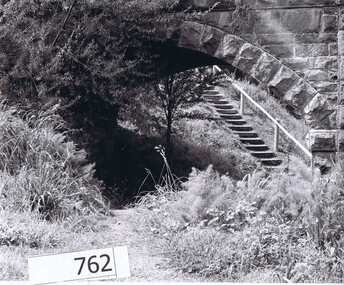
Photograph Collection, Richard Pinn, Plenty River 1979, by Alan Pinn, 1979_
Photographs of the Plenty River Greensborough. One shows Richard Pinn walking his dog (Jah) on track by river, the second photo is a close up of the Greensborough Bluestone Bridge and steps to river. The bridge has since been demolished and the path replaced by a concrete bike/walking path.Shows the river pathways and bluestone bridge in the 1979.2 b&w photographs.plenty river, greensborough, richard pinn -
 Greensborough Historical Society
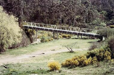
Photograph - Digital Image, Aqueduct Greensborough, 1960c
The Pipe Bridge at Greensborough is a significant and highly visible part of the system. It was constructed to carry the wrought iron aqueduct pipes over the Plenty River. The use of wrought iron meant the pipes were 75% lighter than cast iron, with the bridge construction reflecting this innovation. Photograph of the Maroondah Aqueduct pipe bridge at Greensborough. The Pipe Bridge is 210 feet long, divided into 4 spans. The main girders are light lattice 11 feet deep and 11 ft 4 inches apart. The bridge carried two wrought iron tubular mains, 53 inches in diameter, supported at intervals by cross girders and chairs, placed between the main girders. The bridge is carried on braced cast-iron columns, 18 inches in diameter, set on concrete foundations, with a clear headway of 20 feet above the Plenty River. The eastern side of the bridge is reinforced with a bluestone abutment at the river bank.Digital copy of colour photograph.maroondah aqueduct, aqueduct pipe bridge greensborough -
 Greensborough Historical Society
Photograph - Digital Image, Old pool Plenty River, May 2014, 21/05/2014
Plenty River pool Greensborough. Opened in 1937, the remnants of this concrete pool can be seen today from the Main Street bridge Greensborough. Photograph by Marilyn Smith 2014.Digital copy of colour photograph.plenty river pool, greensborough pool, swimming pools -
 Greensborough Historical Society
Photograph - Digital Image, Old Pool Plenty River 2014, 21/05/2014
Plenty River pool Greensborough. Opened in 1937, the remnants of this concrete pool can be seen today from the Main Street bridge Greensborough. Photograph by Marilyn Smith 2014.Digital copy of colour photograph.plenty river pool, swimming pools, greensborough pool -
 Greensborough Historical Society
Photograph - Digital Image, Old Pool Plenty River May 2014, 21/05/2014
Plenty River pool Greensborough. Opened in 1937, the remnants of this concrete pool can be seen today from the Main Street bridge Greensborough. Photograph by Marilyn Smith 2014.Digital copy of colour photograph.greensborough pool, swimming pools, plenty river pool -
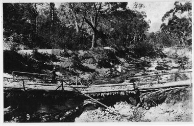 Halls Gap & Grampians Historical Society
Photograph - B/W, C 1880
This photo shows the first Delley's Bridge, built to cross the Fyans Creek to provide access to Halls Gap and beyond in the 1880's. The bridge was swept away a number of times in floods. This bridge was replaced by a higher timber structure but constant erosion of the creek bank eventually led to its replacement by a timber and concrete structure. After nearly 50 years of its use, wear and tear necessitated a fourth bridge to be erected in 2001.A log bridge across a creek with a man standing on the bridge. A woman in a white dress and hat is beside the creek and a man is standing near her on the bank. In the left background a house can just be seen through the trees.structures, bridges -
 Halls Gap & Grampians Historical Society
Photograph, C 1911
This is the second Delley''s Bridge. A new and more substantial bridge was built in 1911, only to be badly damaged in a 1917 flood. The collapsed western end was rebuilt, this time supported by concrete pillars.The photo shows a dirt road crossing a creek via a wooden bridge. A woman is driving a horse and buggy onto the far end of the bridge. There are ferns in the foreground and trees in the background.access routes, roads, structures, bridges -
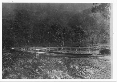
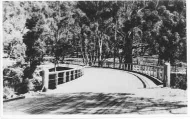 Halls Gap & Grampians Historical Society
Photograph - Photocopy, C 1930s
... The third Delley's Bridge, a timber and concrete structure... Bridge, a timber and concrete structure with a curved deck, built ...The third Delley's Bridge, a timber and concrete structure with a curved deck, built in 1940. It was situated slightly upstream from the previous bridge. After nearly 50 years of its use, wear and tear necessitated a fourth bridge to be erected in 2001.The picture shows a curving bridge with a wood and wire railing. An unsurfaced road crosses the bridge and the area is surrounded by trees.structures, tents -
 Eltham District Historical Society Inc
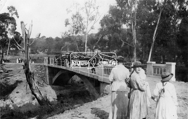
Photograph, Main Road Bridge, Eltham, c.1924
The wooden Main Road Bridge was substantially damaged in the 1924 flood and was replaced with a concrete structure Pages from a scrapbook belonging to Heather Jenkins (nee Sargeant) who lived as a child in the Police Residence at 728 Main Road, Eltham in the 1920s.This photo shows the flood damage to the bridge structure or the dismantling of the bridge post 1924 flood. Heather Sargeant was the daughter of Constable W.C. Sargeant, the local police officer in residence at Eltham, 1922-1927Glued on a brown paper scrapbook page (torn from scrapbook) with 9 black and white/sepia photos of varying sizes, 1 newspaper clipping and handwritten captions in ink.On verso in pencil "Const. W.C. Sargeant 1922-1927 - see Police list"heather jenkins (nee sargeant), eltham, police residence, constable w.c. sargeant, main road, main road bridge -
 Eltham District Historical Society Inc
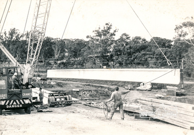
Photograph, Construction of Lower Plenty Bridge, Main Road, c.August 1966, 1966
Black and white photograph of crane lowering concrete girder into placeplenty river, bridge construction, main road, lower plenty, bridges -
 Eltham District Historical Society Inc
Negative - Photograph, Opening of the new bridge at Hurstbridge, 1917
The opening ceremony of new the bridge over the Diamond Creek at Hurstbridge, designed by Sir John Monash. The single arch concrete bride replaced the original wooden structure erected in 1881. People gathering around 3pm for the Official Opening of Hurst's Bridge, 3 November 1917. View of steam train at Hurstbridge Railway Station in distance. Part of a slide show presentation "Bridges & Waterways of the Shire" by Russell Yeoman to the 13 September 1989 Society meeting. The presentation included slides of historic photos from the Shire of Eltham Pioneers collections as well as several recent views. 1917 'HURST'S BRIDGE.', Eltham and Whittlesea Shires Advertiser and Diamond Creek Valley Advocate (Vic. : 1917 - 1922), 9 November, p. 3. (MORNING.), viewed 28 Jul 2018, http://nla.gov.au/nla.news-article57641838This photo forms part of a collection of photographs gathered by the Shire of Eltham for their centenary project book,"Pioneers and Painters: 100 years of the Shire of Eltham" by Alan Marshall (1971). The collection of over 500 images is held in partnership between Eltham District Historical Society and Yarra Plenty Regional Library (Eltham Library) and is now formally known as the 'The Shire of Eltham Pioneers Photograph Collection.' It is significant in being the first community sourced collection representing the places and people of the Shire's first one hundred years.Digital image 120 format B&W negativesepp, shire of eltham pioneers photograph collection, diamond creek, hurstbridge, wattle glen, bridge, mia mia, opening day, sir john monash -
 Orbost & District Historical Society
black and white photographs, 1934
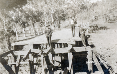
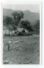
These photographs were taken just after the McKillop's Bridge was completed after the flood damage. The current McKillop’s Bridge was built by the Country Roads Board in two stages between 1931-36, during which its height was raised after the original bridge superstructure was washed away in record floods of January 1934, prior to its original official opening. In its reconstructed form the original concrete abutments were turned into additional piers and the welded-steel trusses were cantilevered back over them to meet the new higher road approaches. It is sited at McKillops Crossing, named after pioneer overlanding squatter George McKillop who crossed here in 1835. This was a stock crossing place for almost a century before the bridge was constructed. (info. from Victoria Heritage Register)This is a pictorial record of the history of McKillop's Bridge, in itself of historical significance for its association with Victoria's long and important pastoral history, its technicl significance and aesthetic significance.Three black / white photographs. 3133.1 shows the approach to a washed away bridge. 3133.2 is of a bridge over a river with men clearing debris. 3133.3 is a close-up showing the wreckage of the bridge.mckillop's-bridge snowy-river flood-damage-1934 -
 Orbost & District Historical Society
black and white photograph, mid 1930s
This is a photograph of McKillop's Bridge probably taken just after its rebuilding. The current McKillop’s Bridge was built by the Country Roads Board in two stages between 1931-36, during which its height was raised after the original bridge superstructure was washed away in record floods of January 1934, prior to its original official opening. In its reconstructed form the original concrete abutments were turned into additional piers and the welded-steel trusses were cantilevered back over them to meet the new higher road approaches. "McKillops Bridge was Heritage listed due to its social and technological significance – the steel trusses' arc-welded construction technique was a pretty big deal in the 1930s. It was once an important route for cattlemen, who used the ford across the Snowy in the years preceding the bridge's existence"This is a pictorial record of McKillop's Bridge just after its construction.A black / white photograph of a wooden bridge across a river. At the bottom right is a man with his back to the camera. He is looking at flood debris on the bank. At the bottom left are two men near a pylon.on back - McKillops Bridgebridge-mckillop's snowy-river-bridge -
 Glen Eira Historical Society
Album - Album page, Hotham Street, Circa 1972
This photograph is part of the Caulfield Historical Album 1972. This album was created in approximately 1972 as part of a project by the Caulfield Historical Society to assist in identifying buildings worthy of preservation. The album is related to a Survey the Caulfield Historical Society developed in collaboration with the National Trust of Australia (Victoria) and Caulfield City Council to identify historic buildings within the City of Caulfield that warranted the protection of a National Trust Classification. Principal photographer thought to be Trevor Hart, member of Caulfield Historical Society. Most photographs were taken between 1966-1972 with a small number of photographs being older and from unknown sources. All photographs are black and white except where stated, with 386 photographs over 198 pages.Victorian Heritage Database - Hotham Street Road Overbridge HO116 Heritage Overlay - City of Glen Eira https://vhd.heritagecouncil.vic.gov.au/places/43557 (as of 04/07/2021) The Hotham Street road overbridge is located on the Sandringham railway line between Ripponlea and Elsternwick railway stations. It is presumed to have been built by contractors Sharp and Campbell who signed a contract on 25th . November, 1881 to construct a second line of railway between Windsor and Elsternwick. This contract was completed during 1882 and the bridge may have been designed in the year when Robert Watson took over from William Elsdon as engineer in chief for the Victorian railways. It is historically, aesthetically and technically significant. It is historically significant (Criterion A) to the extent that it demonstrates the standards of construction adopted by the Victorian Railways Department when it rebuilt the lines acquired from the private railway companies, (compare the Geelong and Melbourne Railway Co's line from Newport to Geelong, acquired in 1860). It is aesthetically significant (Criterion E) as an intact nineteenth century structure of its type, many similar girder bridges having been renewed with concrete girders in recent years. The bluestone abutments demonstrate high standards of stone masonry and are representative of Departmental work of the period. This bridge forms one of a group of historic structures on the railway to Brighton Beach and therefore contributes to the line's cultural importance as a whole. The survival of the riveted iron girders with their bellied angle iron struts is important since these elements are representative of the civil engineering practices of the Victorian Railways at the time and constitute the technical significance (Criterion F) of the structure.Page 96 of Photograph Album with three photographs (one portrait and two landscape) from Hotham Street - two external views of one house and a railway bridge.Handwritten: Hotham Street [top right] / 112 HOTHAM ST [under top left photo] / BRIDGE OVER SANDRINGHAM RAILWAY [under top right photo] / 112 HOTHAM ST CNR MELBY AVE [under bottom left photo] / 96 [bottom right]trevor hart, elsternwick, hotham street, caulfield, houses, brick, bay windows, verandahs, railway bridges, tunnels, gardens, bluestone, civil engineering, victorian railways, sharp and campbell, contractors -
 Flagstaff Hill Maritime Museum and Village
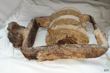
Equipment - Ship Rope Block, Russell & Co, Circa 1886
This double-sheaved wooden ship’s block or pulley is a mechanical device used for lifting and moving heavy objects. It has two grooved wheels joined together, each with an axle between the cheeks or sides of the grooved wheel. Blocks and tackle are included in a ship’s rigging. These pulleys and ropes are used for the mechanical advantage they provide for lifting, moving and re-arranging the setting of the sails, which are very heavy work. Blocks are also used to load and unload the ship’s cargo. The FALLS of HALLADALE- The sailing ship Falls of Halladale was an iron-hulled, four-masted barque, used as a bulk carrier of general cargo. She left New York in August 1908 bound for Melbourne and Sydney. In her hold was general cargo consisting of roofing tiles, barbed wire, stoves, oil, and benzene as well as many other manufactured items. After three months at sea and close to her destination, a navigational error caused the Falls of Halladale to be wrecked on a reef off the Peterborough headland on the 15th of November, 1908. The captain and 29 crew members survived, but her cargo was largely lost, despite two salvage attempts in 1908-09 and 1910. The Court of Marine Inquiry in Melbourne ruled that the foundering of the ship was entirely due to Captain David Wood Thomson's navigational error, not too technical failure of the Clyde-built ship. The Falls of Halladale was built in1886 by Russell & Co., at Greenock shipyards on the River Clyde, Scotland for Wright, Breakenridge & Co of Glasgow. The ship had a sturdy construction built to carry maximum cargo and was able to maintain full sail in heavy gales, one of the last of the 'windjammers' that sailed the Trade Route. She and her sister ship, the Falls of Garry, were the first ships in the world to include fore and aft lifting bridges. The new, raised catwalk-type decking allowed the crew to move above the deck in stormy conditions.This artefact is important as it is an example of the materials and design of late-19th century ship’s rigging equipment. The object is also significant for its association with the historic sailing ship Falls of Halladale, wrecked in local waters in the early 20th century. The clipper ship Falls of Halladale shipwreck is of historical significance and is listed on the Victorian Heritage Register, No. S255. She was one of the last ships to sail the Trade Routes. She was one of the first vessels to have fore and aft lifting bridges. The vessel is an example of the remains of an international cargo ship and also represents aspects of Victoria’s shipping industry.Ship's block; a double-sheave wooden block with thick concretion on it. The rope block was recovered from the wreck of the sailing ship, Falls of Halladale.Noneflagstaff hill, maritime museum, maritime village, warrnambool, great ocean road, shipwreck coast, falls of halladale, shipwreck, peterborough, 1908 shipwreck, peterborough shipwreck, russell & co., greenock, wright breakenridge & co. glasgow, clipper ship, machine, mechanical advantage, block, wooden block, pulley, tackle, sheave, ship rigging, double-sheave, twin sheave, captain david wood thomson, iron ship, four-masted ship, sailing ship, windjammer, clyde, wright, breakenridge & co of glasgow, fore and aft lifting bridges -
 Glenelg Shire Council Cultural Collection
Photograph - Photograph - Portland Harbour, n.d
... Coloured photo. Two workmen on metal bridge between barge... workmen on metal bridge between barge and concrete box on pile ...Port of Portland Authority Archivesport of portland archives -
Glenelg Shire Council Cultural Collection
Photograph - Photograph - Canal Bridge Construction, n.d
Port of Portland Authority Archivesport of portland -
Glenelg Shire Council Cultural Collection
Photograph - Photograph - Bridge Construction, 29/05/1957
Port of Portland Authority ArchivesFront: Back- 'Bridgewater road Bridge (otway street) 29/5/57' - pencilport of portland -
Glenelg Shire Council Cultural Collection
Photograph - Photograph - Bridge Construction, Portland, 13/05/1958
Port of Portland Authority ArchivesFront: Back- '13 May 1958' - purple stampport of portland archives, bridge construction, harbour development -
Glenelg Shire Council Cultural Collection
Photograph - Photograph - Canal Bridge Construction, Portland, n.d
Port of Portland Authority Archivesport of portland archives, canal bridge construction, workmen -
Glenelg Shire Council Cultural Collection
Photograph - Photograph - Bridge Construction, n.d
Port of Portland Authority Archivesport of portland archives -
Glenelg Shire Council Cultural Collection
Photograph - Photograph - Bridgewater Construction, n.d
Port of Portland Authority ArchivesFront: Back- Margin ruled in pencil, diagonal in pencil. 'C' 4x2 1/4 - Pencil 'Bridgewater road bridge 29/3/57 looking s.s.w'- written in blue biro. 'Otway Street Bridge - Pencilport of portland archives, otway street bridge, bridgewater road bridge construction -
Glenelg Shire Council Cultural Collection
Photograph - Photograph - Canal Bridge Construction, 04/10/1957
Port of Portland Authority ArchivesFront: Back- '4/10/57' - top, blue biroport of portland archives -
Glenelg Shire Council Cultural Collection
Photograph - Photograph - Bridge Construction, n.d
Port of Portland Authority Archivesport of portland archives -
Glenelg Shire Council Cultural Collection
Photograph - Photograph - Canal Bridge Construction, n.d
Port of Portland Authority Archivesport of portland archives -
 Flagstaff Hill Maritime Museum and Village
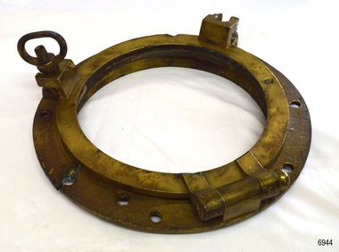
Functional object - Porthole Frame, Russell & Co, Ca. 1886
This restored porthole frame was recovered from the wreck of the Falls of Halladale at Peterborough Victoria. The Falls of Halladale- The ship was an iron-hulled, four-masted barque, used as a bulk carrier of general cargo. She left New York in August 1908 bound for Melbourne and Sydney. In her hold was general cargo consisting of roofing tiles, barbed wire, stoves, oil, benzene, and many other manufactured items. After three months at sea and close to her destination, a navigational error caused the Falls of Halladale to be wrecked on a reef off the Peterborough headland on the 15th of November, 1908. The captain and 29 crew members survived, but her cargo was largely lost, despite two salvage attempts in 1908-09 and 1910. The Court of Marine Inquiry in Melbourne ruled that the foundering of the ship was entirely due to Captain David Wood Thomson's navigational error, not too technical failure of the Clyde-built ship. The Falls of Halladale was built in1886 by Russell & Co., at Greenock shipyards on the River Clyde, Scotland for Wright, Breakenridge & Co of Glasgow. She was one of several designs of the Falls Line of ships named after waterfalls in Scotland. The company was founded between 1870- 1873 as a partnership between Joseph Russell, Anderson Rodger, and William Todd Lithgow. During 1882-92 Russell & Co. standardised designs sped up their building process so much that they could build 271 ships during that time. The Falls of Halladale had a sturdy construction built to carry maximum cargo and was able to maintain full sail in heavy gales, one of the last of the 'windjammers' that sailed the Trade Route. She and her sister ship, the Falls of Garry, were the first ships in the world to include fore and aft lifting bridges. Previously, heavily loaded vessels could have heavy seas break along the full length of the deck, causing serious injury or even death to those on deck. The new, raised catwalk-type decking allowed the crew to move above the deck in stormy conditions. This artefact is important as it is an example of the materials and design of late-19th century ship’s rigging equipment. The object is also significant for its association with the historic sailing ship Falls of Halladale, wrecked in local waters in the early 20th century. The clipper ship Falls of Halladale shipwreck is of historical significance and is listed on the Victorian Heritage Register, No. S255. She was one of the last ships to sail the Trade Routes. She was one of the first vessels to have fore and aft lifting bridges. The vessel is an example of an International Cargo Ship's remains and represents aspects of Victoria’s shipping industry. Porthole frame; cast brass circular frame with several fixing holes, and hinged frame for holding the glass window. The frame has two screw dogs and a solid hinge. The porthole frame has been recondition and the layer of concretion has been removed. The porthole frame was recovered from the wrecked FALLS OF HALLADALE.flagstaff hill, warrnambool, maritime village, maritime museum, shipwreck coast, great ocean road, falls of halladale, shippwreck, shipwreck artefact, porthole, pprthole frame, ship's window, ship construction, shipwreck, peterborough, 1908 shipwreck, peterborough shipwreck, russell & co., greenock, wright breakenridge & co. glasgow, clipper ship -
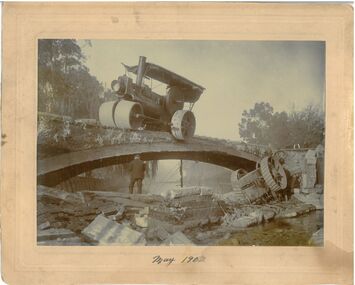 Bendigo Historical Society Inc.
Photograph - Monier Bridge Collapse, May, 1902
In 1867 Frenchman, Joseph Monier patented reinforced concrete horticultural troughs. In 1873 this process was extended to iron reinforced bridges with the first bridge built in 1875. In Australia, Sir John Monash of Monash and Anderson company, originally built 8 Monier bridges in Bendigo all single arch except Weeroona Ave., which was a double arch. Six of these remain.Black and white photograph. Steam rollers appears to have collapsed from a Monier bridge with men investigating amidst the rubble with one steam roller remaining on the bridge, and another resting in a creek underneath. Photograph by W. H. Robinson. Photograph mounted on cream-coloured card.Written on the front in black ink 'May 1902.'monier bridges, bendigo creek, accidents