Showing 309 items
matching construction workers
-
 Kiewa Valley Historical Society
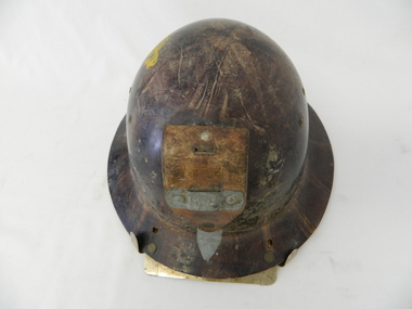
Helmet Safety, circa mid to late 1960's
... by workers during construction of the generators and tunnels ...This helmet worn by SEC Victoria workers in the Kiewa Hydro Electricity Scheme is a mandatory safety requirement by all personnel employed by government and statutory agencies who worked on or around "dangerous" apparatus or underground location sites. This type of pressed fibre helmet was later superseded by moulded plastic helmets. The start of the project (late 1940's) was not greatly covered by later introduced health and safety regulations. This has been demonstrated by photos of workmen outside using heavy machinery and other apparatus, see KVHS 0396, KVHS 0405 and KVHS 0392. However in the tunnels and underground safety helmets were mandatory, see KVHS 0403.This safety helmet was used by workers during construction of the generators and tunnels of the Kiewa Hydro Scheme was issued once only to each worker during his employment covering the 1940's to 1960's period. The attitude to health and safety during this period, can be summed up by this "initiation" ritual. When the helmet had been instrumental in saving a bad accident to a worker, that worker would be "invested" into the "Turtle Club". Although a safety helmet was only issued once to a worker this changed when modern moulded plastic helmets and greater Health and Safety requirements were introduced. Helmets now are replaced bi-annually.This safety helmet is made from pressed fibres with eyelets for airflow to the head. On the base of the helmet (before the rim) are 15 metal eyelets and three quarters up are six other eyelets (3 on each side). A thick leather strap is fastened by two rivettes to the main helmet. This strap has a metal bar rivetted on to affix a "safety" lamp, for underground work (Tunneling). There are two additional metal prongs and a metal bar to secure the lamp on the rim of the front of the helmet.sec vic kiewa hydro scheme, alternate energy supplies, alpine population growth -
 Kiewa Valley Historical Society
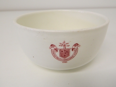
Bowl Ceramic, circa mid to late 1900's
... of Victoria in their mess rooms for their workers during... in their mess rooms for their workers during the construction ...This bowl was used by the State Electricity Commission of Victoria in their mess rooms for their workers during the construction of the Kiewa Hydro Electric Scheme. The imprint of the year "1921" was to identify the year that the SECV was formed which relieved the private VHEC (Victorian Hydro-Electric Company). As the scheme was of such a huge scope, isolated and time consuming nature, the feeding of its workers was quite demanding of cutlery and crockery. The use of sturdy English cups and saucers was essential. The period of construction and the isolation of the Kiewa Valley area placed heavy demand for "solid" crockery that could wear abusive handling. This period in time was one when crockery, whether for domestic or commercial use, was imported from "mother" England. This scenario was more so for governmental bodies such as rail, jails and electricity providers than domestic users. The influx of cheaper Asian crockery had not yet begun.This type of crockery item was used by the thousands of SEC Victorian staff and construction workers involved in the building of the Kiewa Hydro Electricity Scheme, over the extensive period (1938 to 1961). This was a period when Government bodies and other semi- government organisations were still tied to the "establishments" of "mother" England. It was a period in Australia's development when the Asian influence was very weak and the established ties to England and Europe was still very strong. The majority of heavy equipment and machinery was either made in England or Europe. Local/European expertise in dam construction and water management in alpine terrain came from migrants and specialist recruited from England and Europe. The quality of workmanship from big steel manufacturing plants in England and Europe could not be matched from anywhere else in the developed world.This item is a white ceramic State Electricity Commission of Victoria bowl. It is made in England and is of strong and durable ceramic. The 5mm thickness of the ceramic suggests this bowl (cereal/soup) belongs to a commercial kitchen environment and not domestic. The indent bottom of the bowl is 5mm deep with a side curvature ratio of 2:5. The ceramic is glazed to a commercial standard (worker's mess). See also KVHS 0128 (B to D) for other ceramic crockery. The seal of the State Electricity Commission of Victoria is imprinted on the top outside rim within a curved scroll and a raised fist with electrical "charges" extending out.. Snuggled within the borders of the scroll is a banner with the five stars of the Southern Cross . On the underside "Vitrified sold by Cafe & Hotel Supplies Pty Ltd Dunn Bennett & Co. Ltd. Burslem Made in England"ceramic crockery, plate, secv, state electricity commission of victoria, crockery, mt beauty chalet, bogong mess hall -
 Kiewa Valley Historical Society
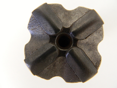
Drill Bit, Circa 1950
... have been used by construction workers to drill holes into rock ...This is the cutting bit on the end of a drilling rod. It would have been used to drill holes into rock for placing explosives, for installing steel rock anchors, etc. In hard rock the bits need to be replaced regularly. Compressed air is blown through the holes near the tip of the bit to blow rock fragments out of the drill hole. The main drilling unit would have been powered by compressed air (Pneumatic). Rotary Air Blast Drilling. This drill bit was used by workers in the SEC Vic. Kiewa Hydro Electricity Scheme. This type of bit although strong needed replacing frequently when the rock composition (type of rock) was extremely compact. The configuration of the tip bit (four star like pattern) was to provide the "teeth" to tear into the rock. This bit was manufactured in 1949 however drilling for rock cores, in the Kiewa Valley and the Victorian Alps, was carried out from the late 1920's.This particular drill bit would have been used by construction workers to drill holes into rock for either explosives or for installing steel anchor points into the rock. The use of compressed air was not only for waste extraction but also for running the main drilling unit.This four star rotary air balst (RAB) drill bit has a central "blow" hole (compressed air outlet to remove the ground rock particles through four extraction holes). There are four raised cutting/grinding lugs which allows the air compression hole(incoming) to always have a clear unblock opening. Extracted ground material is "blown" out from the drill head via the larger hole created by the steel bit.Stamped on the bottom outside shank "FAGERSTA SECO SWEDEN" and below this "102 7041 01 05 049".sec vic kiewa hydro scheme, alternate energy supplies, drilling into rocks in alpine regions -
 Kiewa Valley Historical Society
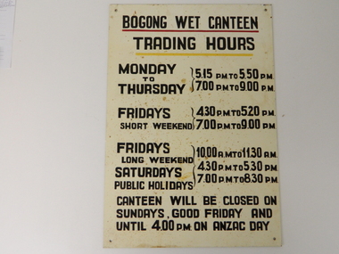
Sign Canteen Painted, Circa 1950
... and construction workers, involved in the building of the Kiewa Hydro ...This sign is a part of the "human" factor required for remote and difficult, large impact (both labour and other resources) projects. It is one of the "human" factors which was clearly used in the big 1930's to the 1970's "landscape redevelopment" schemes which started in the early 1900's and is highly regarded as lifting the Australian psyche of only primary producers to an industrial level, equal to any in the world.This "Wet Canteen" sign was installed at the entrance of the Bogong "workers" village "provision's hut" detailing the operational times for the SEC Victorian staff and construction workers, involved in the building of the Kiewa Hydro Electricity Scheme to obtain alcoholic beverages. This facility lasted for over the extensive period (1938 to 1961) of the "Schemes" building phase. This large project was the forerunner when industrial legislation provided for the welfare of workers living in the Bogong Village. The provision of facilities such as a "wet canteen" was of the utmost importance not only to ensure that the long running project was both successful, production wise, but also that its employees were not only physically but also mentally healthy. This sign details that all aspects required for a fit and productive labour force were in place, in this remote and demanding work environment. The majority of heavy equipment and machinery used was either made in England or Europe. A section of the specialised workforce came from local and European expertise in dam construction and water management in alpine terrain. The majority of labour came from migrants and some specialists recruited from England and Europe. At this point in time, the quality of the machines used came from England, Europe and the USA and could not be matched from anywhere else in the developed world. With a specialised workforce came the responsibility of providing all the "comforts of home" including alcoholic beverages. On site accommodation for the workforce is still a requirement for some mining areas but high market returns have produced fly in/out labour.This anodised metal sign has been "block" stenciled on. Black lettering and numbers with the main headings underlined with a red and a yellow line(emphasising the headings)In black stenciled type "BOGONG WET CANTEEN" underneath this "TRADING HOURS" Below this "MONDAY TO THURSDAY 5.15 PM TO 5.50 PM, 7.00 PM TO 9.00 PM" "FRIDAYS SHORT WEEKEND 4.30 PM TO 5.20 PM 7.00 PM TO 9.00 PM" Below this "FRIDAYS LONG WEEKEND 10.00AM TO 11.30 AM" Below this "SATURDAYS PUBLIC HOLIDAYS 4.30 PM TO 5.30 PM 7.00 PM TO 8.30 PM" bELOW THIS "CANTEEN WILL BE CLOSED ON SUNDAYS, GOOD FRIDAY AND UNTIL 4.00 PM ON ANZAC DAY"saucer, plate, secv, state electricity commission of victoria, canteen, bogong mess hall, recreational amenities, socialisation of sec vic kiewa hydro scheme labour force -
 Kiewa Valley Historical Society
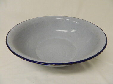
Basin - Enamel, 1940's
The Tawonga District Hospital opened in the early 1950's in the Kiewa Valley to treat local patients from Mt Beauty and the residents of the KIewa Valley. The State Electricity Commission of Victoria assisted with the building of the hospital as the population of Mt Beauty increased with the S.E.C. workers and their families during the construction of the Kiewa Hydro Electric Scheme. The Tawonga Hospital was later relocated to Mt Beauty. All the enamel equipment was eventually replaced with stainless steel.This grey enamel basin is large with a royal blue lip. It was used in the Tawonga District Hospital to wash patients.enamel basin, tawonga hospital, medical, kiewa hydro electric scheme -
 Kiewa Valley Historical Society
Sign - Bogong State School
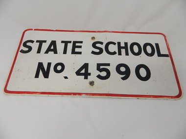
Bogong State School opened in 1941 to provide an education for the employees of the State Electricity Commission of Victoria. The school had up to date equipment and received glowing reports from School inspectors. It closed c1986.Historical: The Bogong State School was opened for the children of S.E.C.V. workers who lived at Bogong in a remote part of north east Victoria. The nearest school would have been 14 miles away and over mountain roads subject to heavy construction traffic and extremes of climatic conditions. Metal sign painted white with thin red border and black block capital letters and numbers. There is a hole in the middle top and middle bottom of the sign."State School / No. 4590"state school. bogong. education. state electricity of victoria. kiewa hydro electric scheme. -
 Kiewa Valley Historical Society
Papers - Mount Beauty Clubs, 1. Mount Beauty Schools' Band; 2) Souvenir of Mt Beauty Senior Citizens Club; 3) Gra-Y and Hi-Y Induction Ceremony
Community clubs in Mt Beauty have always been important due to the remoteness of Mt Beauty situated at the end of the Kiewa Valley and at the bottom of the surrounding mountains.Community clubs in Mt Beauty were and still are important for the well being of members of the community of all ages. Mt Beauty began as a construction town, built by the SECV for their workers on the Kiewa Hydro Electric Scheme. Situated at the end of the Kiewa Valley and at the bottom of the surrounding mountains it has become a tourist town with a strong community spirit and many clubs.1. Mount Beauty Schools' Band End of Year Concert 2002 - 2 A4 pages folded in half with black & white photos on outside cover 2.Souvenir of Mt Beauty Senior Citizens Club - 6 pages printed on 1 side only. Enclosed: Agenda for the official opening - Dec. 1972 3. Procedure for the 'Hi-Y' Induction Ceremony (no date) - 3 foolscap pages printed in blue ink on 1 side only.mt beauty school band, mt beauty senior citizens club, mt beauty gra-y and hi-y clubs, music, athletics -
Kiewa Valley Historical Society
Papers - History of the Shire of Bright taking over Mt Beauty from the State Electricity Commission of Victoria
Mt Beauty township was built as a construction town by the SECV for their workers on the Kiewa Hydro Electric Scheme. In Oct. 1957 the Bright Shire agreed to take over the running of the town At the time it was thought that the section of 'North Mt Beauty ' would disappear. By 1961 and again in 1975, the Shire was still struggling with money for administration and maintenance of the town, including the 'sub-standard' homes in North Mt Beauty. The papers state the agreements made over the years from 1957 to 1975 in order to come to a new agreement.Correspondence between the SEC and the Bright Shire in 1975 confirms that the Shire was struggling to maintain the high standard with increased costs, set by the SEC during construction. "Mt Beauty provides less income to the Shire and offers a poor medium for the reception of grants and CRB assistance'. The papers state the agreements made over the years from 1957 to 1975 with negotiations for a new agreement. This still seems to be a problem in 2021 - a second rate town compared to Bright which makes more money and gets more facilities.A variety of foolscap size papers bound by a rusty fastener. Includes letters re Municipal Administration of Mt Beauty township since the A few pages are hand written.mt beauty township, bright shire, municipal administration of mt beauty, alex mccullough -
 Kiewa Valley Historical Society
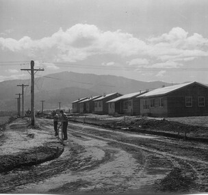
Photo - Mount Beauty Houses circa 1947
A photo of Beauty Avenue houses looking south. A good example of the garden's created very early in Mount Beauty's history. Photo circa 1947These houses were built for the workers and their families during the construction phase of the Kiewa Hydro Electric Scheme by the State Electricity Commission of Victoria.Large coloured photograph with mountains in the background, houses,and SEC poles in the centre, and gardens in the foregroundOn the back in pencil 13411mount beauty housing, kiewa hydro electric scheme, mount beauty gardens, mount beauty township -
 Kiewa Valley Historical Society
Photo: Beauty Ave., Mt Beauty
Mt Beauty was built as a construction town by the S.E.C.V. for workers on the K.H.E.S.. Thee 5 houses in Beauty Ave were the first to be built.The power lines were already erected.Photo: Sepia photo of 5 new houses built at Mt Beauty on the higher side of Beauty Avenue.mt beauty township, beauty avenue -
 Kiewa Valley Historical Society
Tapes - x10 Native Orchids and Birds, Lake Guy
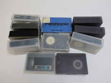
Orchids, birds on the Bogong High Plains and surrounds and the SECV construction on the Kiewa Hydro Electric Scheme were topics of interest for the workers living there. Taping them would have been an interesting hobby for Jack Farrell.Jack Farrell (1920s - 1990s) worked for the State Electricity Commission of Victoria on the KHES. He worked in the workshop and lived on the river side of Simmonds Creek Road. x10 tapes of orchids, birds and Lake Guy etc. and 1 Panasonic Battery Pack VW-VBC4E for movie camera.The battery has a sticker on it "$99.00"orchids, birds, kiewa hydro electric scheme, movies of native flora, movies of birds -
 Kiewa Valley Historical Society
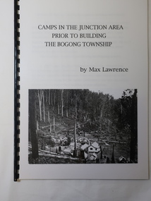
Booklet - Camps at Bogong Junction. 1930s, Camps in the Junction Area Prior to Building the Bogong Township by Max Lawrence
During the construction of the Kiewa Hydro Electric Scheme at Bogong Junction camps of tents were built from 1935. These were replaced by houses for the workers in 1940 when the Bogong township was built.The SECV constructed the Bogong township to house workers on the Kiewa Hydro Electric SchemeA plastic Folder with a black spiral spine and black back cover. 3 pages typed on one side naming and describing the camps at Bogong Junction in the 1930s.miners camp, staff camp, reservoir camp, bogong township, lewis construction camp, albion quarry camp -
 Kiewa Valley Historical Society
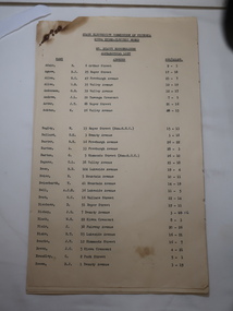
Papers - Mt Beauty Householders c 1959, SECV Kiewa Hydro Electric Scheme Householders
Mt Beauty was a construction town built by the State Electricity Commission of Victoria during construction of the Kiewa Hydro Electric Scheme from the late 1940s to 1961This is a list of the original occupiers of the homes in Mt Beauty township. Houses were allocated to teachers, medical staff etc. as well as to SEC workers.14 foolscap papers. Title SECV, KHES, Mt Beauty Householders, Alphabetical List, Name, Address and Sec/Allot. See KVHS 1264mt beauty residents, mt beauty householders, secv employees -
 Kiewa Valley Historical Society
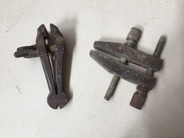
Tools - Vice and Clamp
... , woodworkers, furniture makers, welders, construction and metal workers ...Very old vice. The clamp is 50 to 60 years old when they were made by Technical School students in metal work class.Used by carpenters, woodworkers, furniture makers, welders, construction and metal workers in the Kiewa ValleyMathieson's Hand Vice, the smallest at 3 inches. Ref. Page 74 Tools for all Trades Catalogue. Small steel vice consisting of two parallel jaws for holding a workpiece. One jaw is fixed and the other movable by a screw. The clamp is used for holding a workpiece during hand operations eg. filing, hammering or sawing. Small steel clamp is a versatile tool that serves to temporarily hold work securely in place by screwing each jaw together.vice/vise tool, clamp tool, hand tools -
 Kiewa Valley Historical Society
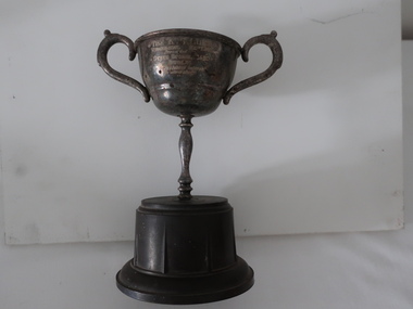
Trophies - Bogong Primary School
Trophies were awarded to recognise achievements in many areas of the school curriculum. Sir Kenneth George Luke (1896-1971) was a successful businessman and VFL football administrator. K.G.Luke was a private mint that made 1956 Olympic Games medals for the Numismatic Association of Victoria. It operated between 1937 and 1974. Note: 'Rosebowl replica' may refer to the Rose Bowl Home of the UCLA Football Layered Wooden Stadium Replica With the Los Angeles Campus Skyline. (A football reference for the shape of the trophy?)Bogong Primary School was built for the workers of the SECV during the construction of the Kiewa Hydro Electric Scheme. The school was well equiped and presented a broad curriculum enjoying participation in many organisations. A. Bakelite base with stained metal cup attached to a metal stem with a cup on top. The cup has 2 curved handles and an inscription between them on one side. B. Bakelite base with a metal stained 'silver' cup attached. The cup has a 'neck' with the cup on top. The cup has one curved handle. The other handle is missing. Previously UKV 058 and UKV 061B. The K. G. Luke / Trophy for replica sustained interest in bird study / presented / State School 4590 / Bogong / for sustained interest / in bird study A. "A.M.V -4 / Pet Parade / Save the Children / Fund bogong primary school, pet parade, bird study, k.g. luke trophy -
 Kiewa Valley Historical Society
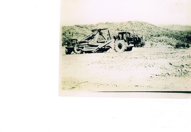
Photograph Tournapull, Tournapull C Scraper/Single Bucket, circa 1950
The machinery in this photo shows a Tournapull C earth moving machine, one of many during this period Circa 1950 - 1960s when hydro electricity powered turbines were being constructed in both the Victoria and New South Wales Alps. This was Australia's answer to a non polluting supply of electricity for a fast growing city population. It was at this time that air pollution from coal powered furnaces was becoming more and more under attack by health authorities.This item is part of a visual account of the construction of dams and hydro electricity facilities during the early 1950s. It was the beginning of the environmental push not to allow the degrading of Australian Alpine regions. Air pollution of the major cities and the increase in power demands of both industries and population within them required an alternative pollution free alternative electricity supply. These for runners of Hydro electricity generators required both large supplies of machinery and human resources. This construction phase within the region brought not only tradesmen but also unskilled workers to an area which had mainly had farming and mining activities. It was the catalyst for the creation of the smaller towns/villages e.g. Bogong Village, Mount Beauty and Bright.Black and white photograph on Kodak Xtralite II paper.(gloss)paper marking on back Kodak Xtralite II papermining, hydro electricity, victorian alps, construction camps, earth moving machines, secv -
 Kiewa Valley Historical Society
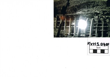
Photograph Junction Dam, Photo Junction Dam and Bogong Village in Background, circa 1950s
... , details the harsh conditions faced by construction workers ...This item clearly shows the conditions covering both working conditions and housing in the construction of the Junction Dam in the 1940s. Working conditions were extreme and health and safety legislation was at its infancy. The residential buildings were intended to last only for the period of construction, however greater demand for longevity as a tourist haven prevailedThis photo of the construction of the Junction Dam, with The Bogong village as backdrop, details the harsh conditions faced by construction workers, building dams and villages to accommodate workers in the 1940s to the 1950s. Australia at this period in time, experienced a surge of population (influx of World War II refugees), which was the catalyst for developing and undergoing an enormous hydroelectricity program for the Alpine regions, both in Victoria and New South Wales. This program was initiated to supply electricity to the major southern Australian cities of Adelaide, Melbourne and Sydney. It was thought that these developments would reduce, if not eliminate, the requirement for coal driven power stations. However time has demonstrated that these power stations have not matched the demand required by the industries and the populations of the major urban and cities.Black and white photo of original photo with a flashlight reflection in the bottom centre. The photo is on Kodak XtraLife II paper. The paper is semi gloss.This photo is of the construction of the Junction Dam Wall with the Bogong Townshiip in the background.Back of photo is printed " Kodak XtraLite II paperdam construction, bogong village, alpine development, junction dam -
 Kiewa Valley Historical Society
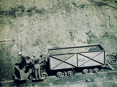
Photograph Shovel Truck, Shovel Loading Rail Truck, circa 1950s
... ) and place (Bogong and Mount Beauty) where construction workers had ...This item shows the excavation of the side of a railway track using a pneumatic shovel and a rail mounted truck by two workmen. The period covered was well before State Health and Safety requirements, such as helmets, became law. It also details that the workmen were from European heritage as their head coverings were a handkerchief knotted at each corner. This was typical for workmen of this heritage, others used caps or hats or no head covering at all (the macho male look)The photograph of this item was one of many depicting great achievements and opening up the region. A visual link or time capsule of the 1950s rural/mining sectors clashing with the established rural industriesThis photo depicts the time (1950's) and place (Bogong and Mount Beauty) where construction workers had an immense impact, not only on the physical environment but also on the social and economic development of the Victorian Alps region. The fast expansion of smaller settlements brought about increased pressures on the welfare viability of certain subgroups within the region e.g. farming, droving and commerce (caravan hawkers versus static shops). These changes brought about a heightened awareness by both local and State Governments to upgrade not only facilities within the region but also access to the region. Black and white photo of two workmen on a rail mounted shovel truck. The photo is of good definition allowing a clear view of the subject matter. The paper is semi gloss.On the back of the photo, paper suppliers etchings are "Kodak XtraLife II paper"mining, hydro electricity, victorian alps, construction camps, earth moving machines -
 Kiewa Valley Historical Society
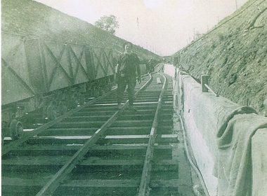
Photograph KHS Rail, Kiewa Hydroelectric Scheme Railway, Circa1940s
... an era when there were 4,000 construction workers located in two ...This photograph shows part of the railway constructed and used for the removal of soil and rocks from the tunnels bored out of the mountains for the pipeline servicing the Hydro Electricity power stations in the Kiewa Hydroelectric Scheme. This photo details an era when there were 4,000 construction workers located in two main accommodation camps, Mount Beauty (the larger one) and Bogong village. These accommodation sites were constructed and maintained as a secured or gated residential area with access only available by a special pass authorised by the Kiewa Hydroelectric Scheme. All the power used by the rail system was from electric motors connected to batteries. Overhead power poles seen on either side of the embankment details that electricity from the Scheme was in use. This use was cleaner and more environmentally friendly than the coal still used by large locomotives from city to country railways. The worker shown is not however wearing protective head and hand coverings. This is also an era where there was a lack of health and safety legislation covering workers in dangerous working conditions.Scanned photo of original black and white photo on Kodak XtraLife II paper. Picture is of a section of railway track servicing the tunnels of the Hydroelectric scheme during the 1940s - 1950sOn back of photo "Kodak XtraLife II paper"railway in kiewa electric scheme, tunneling -
 Kiewa Valley Historical Society
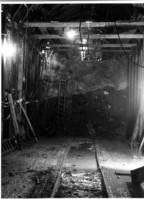
Photograph Tailrace tunnel Arch Drive, Tunnel face at Tailrace showing Arch Drive, between 1943 and 1952
This photo was taking during construction of the tailrace tunnel between West Kiewa Power Station and Mt. Beauty. Much of the area was unstable and timber supports were erected prior to concreting. The tunnel was commenced in 1941 and completed in 1952. It brings water from the power station into the open tailrace at Mt. Beauty and then into the regulating pondage before discharge into the Kiewa River.Shows method of construction for supporting walls and ceiling of tunnel with timber, size of tunnel (note worker on upper level), and conditions in the work place during construction in the 1940's/50's - note the timber ladder to gain access to the upper level.Black and white photographHand written on back of photograph "Tunnel face at Tailrace showing Arch Drive".tailrace, power station, water, construction -
 Kiewa Valley Historical Society
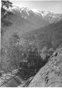
Photograph of Bogong Creek Raceline, Bogong Creek Raceline, circa 1951
A start on the construction of Bogong Creek race line was made at the commencement of winter in 1948. Work proceeded in the following years when work on the High Plains was not practicable. In January, 1951 the special trimming machine, the special slip form and concrete mixing and placing equipment was put into service. A shortage of cement caused some delays as well as a sudden financial recession. The race line was completed and put into service in 1952. An historical record showing the machinery used , the number of workers needed at any one time ( about 16 in this photo) and the mountainous terrain of the area. Black and white photograph taken during construction of Bogong Creek Raceline, showing the type of machine used for the formation of the concrete lining, the mountainous terrain, a number of workmen and a snow capped Mt. Bogong in the backgroundHandwritten on the back of photograph in black ink "Bogong Creek race line".race line, cement, machinery, bogong -
 Kiewa Valley Historical Society
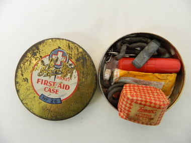
Functional object - Pocket First Aid, Circa mid 1900s
... of the construction workers associated with the Hydro Scheme. also brought ...This pocket First Aid kit is small and compact which became available to those venturing out in the outback and required an easily managed first aid kit. It was manufactured in the mid 1900s well before vinyl and or plastic pouches or bags where used. It was in an era where valuable items were stored in durable containers due to the harsh and rugged conditions of the Australian bush. Cheaper and less durable containers from Asian manufacturers had been kept out by the heavy Tariff imposed on their goods. This changed in the 1980's when the Tariff Board was dismantled by a then Labour Government. The Australian manufacturing industry was severely reduced by the Influx of cheaper goods. This item was made by an Australian company when the motto "true blue" was the catch cry for quality Australian made goods. This was in the period where the isolation of many rural communities required the basic first aid kits to be of a tougher quality than those offered in large cities and towns.This pocket first aid kit was very compact and would have been easy to carry without taking up too much space for bush walkers, camping scouts, drovers and independent miners and cattlemen. The Kiewa Valley and surrounding rural settlements did not have the medical backup that the larger cities and towns had up until the mid 1900s when the Hydro Electricity Schemes were built and the additional influx of workers made it feasible to have a hospital and better local health facilities. This influx of the construction workers associated with the Hydro Scheme. also brought European workers who where more inclined to go bush walking and climbing the Victorian alps than the average Australian rural worker. This item is a Sanax pocket first aid round tin, gold in colour with red and white print. It's contents are: one small tube of Sanax antiseptic cream, one small one inch x six yards of gauze bandages, rubber band type ligatures with a cast iron tightener., one small tweezers three safety pins, and one lancet.On the lid there are: are outlined white cross on a blue circular background. underneath is a whiite circle encased with a red line with the following printed "Sanax pocket first aid case" (in red print underneath this is a small curved blue background and in black print "No. 26"medicine, first aid tin, camping medical supplies, personal first aid, sanax -
 Kiewa Valley Historical Society
Book - Non Fiction History, The Kiewa Story, circa 1993
... at that moment in time, especially for those workers fleeing a devastated ...This book provides in chronological order the development of the Kiewa Hydro-electricity scheme from the first concept (1911) to final construction work (1961). It covers the first attempt to utilise the power of the Victorian Alps water system. It started from a private syndicate and developed to the current State Electricity Commission of Victoria. The incentive for the Hydro scheme was to make money and not as an alternative to the carbon producing coal fired power plants. These coal fired power plants were increasing in numbers to service an ever increasing demand made by population expansion, especially in cities and large rural settlements. This demand spiraled up after World War II when there was a tremendous spike in immigration numbers due to refugees and displaced persons in Europe. The ability to utilise the untapped water provided by the winter snow fields, for a higher yield in electricity, was a powerful incentive to overcome the physical hardships in this remote Alpine region. Future power requirements may initiate the re-installation of the other two power stations(Pretty Valley and Big Hill) covered in original Scheme. This publication not only covers the development of the Kiewa Valley region with respect to population (within a socio-economical framework) but also the subtle but yet strong physical changes of a relatively pristine alpine region. The demands that an ever growing regional population places on the environment is clearly documented in print and black and white photographs. The working and living conditions of those who constructed and gave life to this hydro scheme is well documented in this book. It may be viewed as spartan now but was relevantly good at that moment in time, especially for those workers fleeing a devastated European environment. The successful planning and consideration to minimising any intrusion upon the natural alpine forests and high plains can viewed as an example (compared to the Tasmanian Hydro schemes) of how future hydro schemes (an inevitable requirement) will proceed. Most rural towns (in the early 1900s) were built by unencumbered rural based citizens, with the exception of Mount Beauty and Falls Creek. These two settlements were brought into life by a State (Victorian) Authority for a specific function and program. They were a gated community, that is, only open to construction workers involved with the hydro scheme. All facilities within these communities were provided by the State Electricity Commission of Victoria. The impact on the social, financial and individual independency of the community, by the transition from the S.E.C .environment to one of local government (Shire of Bright), had in some cases a severe impact.This hard covered book has a green cover with pictures on the front and back covers. The front cover has a coloured picture of a snow covered Mount Bogong taken from the opposite mountain range. The valley between both ranges has a whisk of mist over it. At the bottom of this picture are three black and white photographs covering the construction of the Kiewa Hydro - Electricity Scheme. On the back cover is a photograph, (black and white) detailing the Bogong village and Junction dam containing lake Guy. The inside front cover is a black and white photograph which details the construction of the West Kiewa tailrace tunnel during April 1951. The inside back cover is a black and white photograph of the concrete pour at the Clover Dam circa 1952. All photographs and sketches are in black and white. The pages are approximately 160 g/m2 and those which have photographs are on gloss paper.Book spine: "The Kiewa Story Graham Napier Geoff Easdown" alongside this is a white framed circle with white spokes radiating out and underneath in white lettering SECkiewa valley, hydro scheme, victorian alpine region, electricity generators, graham napier, geoff easdown -
 Eltham District Historical Society Inc
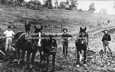
Photograph, Railway construction gang, possibly at Eltham North, c.1910
Railway construction gang with horses possibly working on the Eltham to Hurstbridge line extension near Eltham North, c.1910Black and white printrailways, workers, horses, eltham north, butty gang, construction gang, plough, railway construction -
 Ringwood and District Historical Society
Photograph, Building the old Ringwood Baths in Ringwood St. 1934, incl Newspaper Articles
Black and white photograph. Several articles from Ringwood newspapers and the Argus (images attached) show the initial idea as Nov 1933 (3000-01 Ringwood Baths-Idea.jpg), Commencement in January 1934 (3000-02 Ringwood Baths-Start.jpg), and operational by November 1934 (3000-03 Ringwood Baths-Operational.jpg). An Argus article (via Trove) from 15 Mar 1934 describes a union complaint about use of workers on sustenance in the construction.(3000-04 Ringwood Baths-Complaint.jpg) Typed below photograph, "Building the old Ringwood Baths in Ringwood St. Looking towards Warrandyte Rd. 1934. -
 Flagstaff Hill Maritime Museum and Village
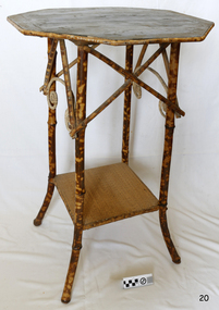
Furniture - Plant Stand, Late 19th Century (1898)
During the years 1869-1935 there were well over 250 registered bamboo furniture producers in Britain. The earliest recorded firm was Hubert Bill of 14 Little Camden St, London N.W., who claimed to have been established in (1869) while Daniel Jacobs & Sons of Hackney Road, London, were still in business in 1915, after 45 years of production. Design, quality, price and methods of construction were fairly consistent throughout the whole period, but it was the imaginative and often eccentric choice of subject matter that marked differentiation between the various firms. While most produced standard tables, stands and fire-screens, the more adventurous offered for sale items such as corner shelve units, charcoal barbecue grills and musical tea tables. Shelves were often covered with embossed leather paper designs, at first imported from Japan and then later produced in England. Some firms incorporated the knobbly roots of the bamboo stems into their designs, generally to form feet. Occasionally handles to drawers and cupboards were made with these roots although they were more commonly carved as imitations. Handles were mostly of cheap metal or brass. The ends of the bamboo canes were capped with stamped metal or turned bone, ivory or wooden discs. Methods of construction fell into three categories. First and most common is that of pegging. Bamboo stems being hollow, thick dowels can easily be glued into the joints. Some firms farmed out this work of `plugging' the ends of the canes to part-time workers at home. The second method, that of pinning, was far less satisfactory as bamboo tends to split lengthwise and therefore the jointed pieces eventually disintegrated. The most efficient method was that patented in 1888 (patent No 2383) by the firm of W. F. Needham in Birmingham. It consisted of metal shoes and covers for all joints which were made by wrapping a metal strip around the stems and soldering the overlapping ends. Some joints were further strengthened by a small pin or screw. Needham was by far the largest and most successful manufacturer and their individual and superior method of construction undoubtedly gained them their reputation. A. Englander & Searle of 34 Gt Eastern St and 31 Mare St, Hackney, London, were a firm particularly concerned with methods of construction. Although they seem to have entered the bamboo furniture market at a comparatively late date, about 1898, they produced inexpensive' bamboo, aimed particularly at the export trade. Stating in their catalogue that bamboo furniture “can be exported in one piece or it can be exported in pieces and put together again. The fixing up is much facilitated by a system of marking and numbering. Further, no glue is required for putting together as the screw system only is applied”. This method of construction best fits the Etagere and this item in the flagstaff collection and it is believed to have been made by A Englander & Searle, exported in a knock down form to Australia, purchased in kit form from a dealer here and put together by the purchaser. The bamboo plant stand is a significant item as it highlight furniture fashion of the late Victorian era. This item was highly sort after in its time and although mass produced, not many examples remain because the item is so fragile so this example is a valuable addition to the Flagstaff collection. It is believed,the construction method used is by a notable and respected maker in England of bamboo furniture that was aimed specifically at the export market and probably came to Australia in kit form to be assembled by the purchaser.Bamboo plant stand with octagonal top edged with tortoise shell bamboo the top is of wood and supported by four tortoise shell bamboo legs joined at the base by a square cane covered shelf. The tortoise shell appearance is brown lacquer. Item is part of the Giles Collection. flagstaff hill, warrnambool, shipwrecked coast, flagstaff hill maritime museum, shipwreck coast, furniture, plant stand, bamboo furniture, etagere, victorian furniture, simulated bamboo, tortise shell, a englander & searle, domestic furniture, giles collection, henry giles, cooramook, mailor’s flat, wangoom, 19th century household goods -
 Flagstaff Hill Maritime Museum and Village
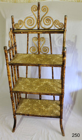
Furniture - Shelves, A. Englander & Searle, Late 19th Century (1898)
This music stand set of shelves is one of many 19th century items of furniture, linen and crockery donated to Flagstaff Hill Maritime Village by, Vera and Aurelin Giles. The items are associated with the Giles Family and are known as the “Giles Collection”. Many of the items of furniture, linen and crockery in the Lighthouse Keeper’s Cottage were donated by Vera and Aurelin Giles and mostly came from the simple home of Vera’s parents-in-law, Henry Giles and his wife Mary Jane (nee Freckleton) whose photos are in the parlour. They married in 1880. Henry, born at Tower Hill in 1858, was a labourer on the construction of the Breakwater before leaving in 1895 to build bridges in N.S.W. for about seven years. Mary Jane was born in 1860 at Cooramook. She attended Mailor’s Flat State School where she was also a student teacher before, as family legend has it, she became a governess at “Injemiara” where her grandfather, Francis Freckleton, once owned land. Henry and Mary’s family of six, some of whom were born at Mailor’s Flat and later children at Wangoom, lived with their parents at Wangoom and Purnim west, where Henry died in 1933 and Mary Jane in 1940. THE SHELVES During the years 1869-1935 there were well over 250 registered bamboo furniture producers in Britain. The earliest recorded firm was Hubert Bill of 14 Little Camden St, London N.W., who claimed to have been established in (1869 the first bamboo furniture maker), while Daniel Jacobs & Sons of Hackney Road, London, were still in business in 1915, after 45 years of production. Design, quality, price and methods of construction were fairly consistent throughout the whole period, but it was the imaginative and often eccentric choice of subject matter that marked the differentiation between the various firms. While most produced standard tables, stands and fire-screens, the more adventurous offered for sale items such as Corner shelve units, charcoal barbecue grills and musical tea tables. Shelves were often covered with embossed leather paper designs, at first imported from Japan and then later produced in England. Some firms incorporated the knobbly roots of the bamboo stems into their designs, generally to form feet. Occasionally handles to drawers and cupboards were made with these roots although they were more commonly carved as imitations. Handles were mostly of cheap metal or brass. The ends of the bamboo canes were capped with stamped metal or turned bone, ivory or wooden discs. Methods of construction fell into three categories. First and most common is that of pegging. Bamboo stems being hollow, thick dowels can easily be glued into the joints. Some firms farmed out this work of `plugging' the ends of the canes to part-time workers at home. The second method, that of pinning, was far less satisfactory as bamboo tends to split lengthwise and therefore the jointed pieces eventually disintegrated. The most efficient method was that patented in 1888 (patent No 2383) by the firm of W. F. Needham in Birmingham. It consisted of metal shoes and covers for all joints which were made by wrapping a metal strip around the stems and soldering the overlapping ends. Some joints were further strengthened by a small pin or screw. Needham was by far the largest and most successful manufacturer and their individual and superior method of construction undoubtedly gained them their reputation. A. Englander & Searle of 34 Gt Eastern St and 31 Mare St, Hackney, London, were a firm particularly concerned with methods of construction. Although they seem to have entered the bamboo furniture market at a comparatively late date, about 1898, they produced inexpensive bamboo, aimed particularly at the export trade. The company stated in their catalogue that bamboo furniture “can be exported in one piece or it can be exported in pieces and put together again. The fixing up is much facilitated by a system of marking and numbering. Further, no glue is required for putting together as the screw system only is applied”. This method of construction best fits the Etagere in the Flagstaff collection and it is believed to have been made by A Englander & Searle, exported in a knock down form to Australia, purchased in kit form from a dealer hear and put together by the owner. The Etagere is a significant item as it highlight furniture fashion of the late Victorian era. This item was highly sort after in its time and although mass produced, not many examples remain, so this example is a valuable addition to the Flagstaff collection. It is believed that the construction method used is by a notable and respected maker of bamboo furniture and that its production was aimed at the export market and probably came to Australia in kit form.Bamboo shelves: decorative free standing Etagere comprising three large shelves and one small shelf. Shelves are made of wood used to store either orange or bacon boxes (as there are no knots in the wood, imported from South America and cheap to recycle). Shelves are covered with embossed leather paper. Frame is made from tortoise shell bamboo (brown lacquer applied to simulate tortoise shell appearance). Ends of bamboo canes are covered with metal shoes and fixed with a pin. Other bamboo joints are fixed with round head steel screws. This item is part of the Giles Collection.Noneflagstaff hill, warrnambool, shipwrecked-coast, flagstaff-hill, flagstaff-hill-maritime-museum, maritime-museum, shipwreck-coast, flagstaff-hill-maritime-village, bamboo shelves, bamboo etagere, victorian furniture, furniture, bamboo furniture, embossed leather paper, simulated bamboo, tortise shell, a englander & searle, giles collection, henry giles, tower hill, cooramook, warrnambool breakwater, mailor’s flat, wangoom, 19th century furniture -
 Glen Eira Historical Society
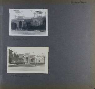
Album - Album page, Elsternwick Club, Sandham Street, Circa 1972
... , leading to the construction of low cost workers housing ...This photograph is part of the Caulfield Historical Album 1972. This album was created as part of a project from approximately 1966-1972 by the Caulfield Historical Society to assist in identifying buildings worthy of preservation. This album is related to a Survey the Caulfield Historical Society developed in collaboration with the National Trust of Australia Victoria and Caulfield City Council to identify historic buildings within the City of Caulfield that warranted the protection of a National Trust Classification. Photographers Jenny O’Donnell and Trevor Hart, members of Caulfield Historical Society. Some photographs are older and from unknown sources. All photographs are black and white except where stated. From Victorian Heritage Database citation for HO60 Stanmere/Elsternwick Club, 19 Sandham Street Elsternwick https://vhd.heritagecouncil.vic.gov.au/places/35422 as at (1/11/2020) An imposing single storeyed stuccoed Boom period Italianate villa residence, distinguished by its bayed and pedimented projecting wing and central portico with surmounting pediment and urns. The cast iron verandahs, to two elevations, have tessellated floors and are partly built-in. From Victorian Heritage Database citation for HO60 Stanmere/Elsternwick Club, 19 Sandham Street Elsternwick https://vhd.heritagecouncil.vic.gov.au/places/35422 as at (1/11/2020) "Stanmere" is locally important as the home of the Short family whose decision to sub divide its holdings was linked closely with the profiteering ventures of the directors of the Premier Building Association, leading to the construction of low cost workers housing characteristic of the land boom speculators prior to the bank crash of the early 1890's.Handwritten: Page 186 of photo album with two photographs of the Elsternwick Club.Handwritten: Sandham Street [top right] / BOWLING CLUB [under top photo] / ELSTERNWICK CLUB [under bottom photo] / 186 [bottom right]trevor hart, victorian, chimneys, porch, cast iron lacework, verandah, sandham street, victorian villa residence, villa residence, cast iron frieze, cast iron columns, protruding bay, bay window, 1880's, late victorian, decorative brackets, rendered, arched windows, ornamented parapet, short family, premier building association, elsternwick club, boom years, elsternwick, pediment, stanmere, bowling club, club, bowling, land subdivision, cast iron work, tessallated floors -
 Glen Eira Historical Society
Letter - Rosstown Railway
This file contains two items: 1/A group of eight letters, predominantly between Hon. Secretary of Caulfield Historical Society R. Ballantyne and members of the Caulfield City Council written between 1981 and 1983, regarding the installation of a plaque in commemoration of the centenary of the Rosstown Railway. The first two letters are handwritten from R. Ballantyne to G. Calder and Carol Camy, dated 01/06/1981 and 22/02/1982. The letter to G. Calder supports a suggestion in the May edition of the CAULFIELD CONTACT for the installation of a plaque in celebration of the centenary of the Rosstown Railway, suggesting a potential site for another plaque on Curraweena Road. The letter to Carol Harry discusses the costing of the plague and a possible contribution towards this cost from the Caulfield Historical Society. The letter appears to be incomplete, having no sign off from the author. Attached to the letter is what appears to be a suggestion for the inscription of the plaque. The letters addressed to R. Ballantyne are typed and dated 12/06/1981, 24/06/1981, 14/07/19891, 17/12/1981 and 08/09/1983, from A. Craig and D.B. Hogan on behalf of City Manager G.K. Calder and City Liason Officer Carol Harry. All letters concern the commemorative plaque, with these from Carol Harry including handwritten notes which appear to be in R. Ballantyne’s handwriting. The final letter is from Mayoral Secretary Norma Polglase to Miss B. Snowball, dated 23/08/1983, inviting her to attend the unveiling of the plaque. Also included in the item are Council Committee Meeting minutes, dated 16/05/1981, broaching the subject of installing the plaque in Koornang Road. 2/Four colour photographs and two black and white copies of one of the photographs, all dated 18/09/1983 and showing the opening of the commemorative plaque in Marrara Gardens. Two photographs picture Mayor Brian Rudski and City Manager Graham Calder with a crowd of unidentified people present. One photograph and both copies are of the inscription on the plaque, with the wording identical to that of the handwritten note by R. Ballantyne, in item one.caulfield, caulfield south, calder g.k., calder g., hawthorn road, glen eira road, ballantyne r., office workers, caulfield contact, norman peter, groups, glen huntly, koornang road, mills, sugar mills, caulfield historical society, caulfield city council, caulfield town hall, official buildings, glen huntly neville street fourteen, parliamentary representatives, rosstown, rosstown railway, rosstown railway centenary, festivals and celebrations, centenaries, historical markers, plaques, monuments and memorials, ross murray, railways, land transport, curraweena road, parts of buildings or structures, bluestone structures, construction materials, caulfield community liaison officer, harry carol, currency, finances, onley peter, elsternwick, oakleigh, council meetings, caulfield council chambers, caulfield municipal chambers, caulfield municipal offices, craig a., caulfield city manager, city of caulfield, caulfield physical environment committee, public meetings, meetings, ross james, hogan o.b., arrow engraving, campbell f., snowball miss., elsternwick gladstone parade nineteen, walters w.r., marara road gardens, marara road, marara gardens, narrawong road, ceremonies, caulfield mayors, polglase norma, mayoral secretaries, railways routes, documents, correspondence, rudski brian, calder graham, events and activities, official buildings, insignia, local government, local officials and employees, parks and reserves, buildings structures and establishments, official events, festivals and celebrations, occupations, political processes, local history, history, financial economics, local government finance -
Glen Eira Historical Society
Book - Robertson, Alexander William
... Victorian Style Grants Voluntary Workers Property Development ...Contains one item about 'Labassa', called 'Ontario' when owned by Alexander William Robertson: 1/One copy of a thirty-two page colour book, published by the Friends of Labassa and The National Trust in 2004. The book details the history of Labassa (and its owners) as a place for social gatherings and entertaining of Melbourne society of the late nineteenth century, and its letter use as flats and a boarding house. Extensively illustrated with colour photographs, architectural sketches and plans, the book LABASSA: A GRAND VICTORIAN MANSION details Labassa’s architectural significance Please refer to file 1113Y for the other copy of this book. For further information about Labrassa please refer to file 1113.labassa, ontario, sylliott hill, caulfield north, friends of labassa, manor grove, national trust of australia (victoria), balaclava road, orrong road, caulfield, mansions, cobb and co., amatil ltd. (limited), alcoa of australia ltd. (limited), lyall william, mickle john, billing richard annesley judge, robertson alexander william, watson john boyd ii, koch john augustus bernard, hammond victoria, palmer lee, davis kingsley, groenhout chris, worrall bronwyn, balderstone sue, biarujia ian, cassidy darien, davidson rodney ao obe, forge warwick, lewis miles dr., sagazio celestina dr., billing mary, billing williamina, billing richard junior, watson flora kate, robertson eva, robertson nina, robertson emily, robertson john, australian-german association, bicentennial gift to the nation, ferguson and urie, crouch and wilson, tangent design, midas printing (asia) limited (ltd), flats, architectural features, architectural styles, auctions, land sales, land subdivision, architects, lawyers, judges, coaches and carriages, businesspeople, german community, victorian style, grants, voluntary workers, property development, construction (events and activities), gold mining, theatrical productions, stairs, stained glass, settlements, graziers, verandas, cast iron work, marble, balconies, bell towers, towers, bay windows, panoramic views, bedrooms, servants quarters, billiards rooms, rooms, fireplaces, sculpture, servants, marvellous melbourne, land use, depression 1890s, photography, photographers, entrance hall, domestic life, cultural events and activities