Showing 270 items matching "country roads board"
-
 Orbost & District Historical Society
black and white photograph, mid 1930s
... was built by the Country Roads Board in two stages between 1931-36... was built by the Country Roads Board in two stages between 1931-36 ...This is a photograph of McKillop's Bridge probably taken just after its rebuilding. The current McKillop’s Bridge was built by the Country Roads Board in two stages between 1931-36, during which its height was raised after the original bridge superstructure was washed away in record floods of January 1934, prior to its original official opening. In its reconstructed form the original concrete abutments were turned into additional piers and the welded-steel trusses were cantilevered back over them to meet the new higher road approaches. "McKillops Bridge was Heritage listed due to its social and technological significance – the steel trusses' arc-welded construction technique was a pretty big deal in the 1930s. It was once an important route for cattlemen, who used the ford across the Snowy in the years preceding the bridge's existence"This is a pictorial record of McKillop's Bridge just after its construction.A black / white photograph of a wooden bridge across a river. At the bottom right is a man with his back to the camera. He is looking at flood debris on the bank. At the bottom left are two men near a pylon.on back - McKillops Bridgebridge-mckillop's snowy-river-bridge -
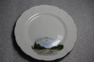 Wodonga & District Historical Society Inc
Memorabilia - Souvenir Plate Pollard Arch, Wodonga, Victoria, C. 1960s
... for £1230. When the Country Roads Board said the causeway would have... the Country Roads Board said the causeway would have to be duplicated ...A wide range of souvenirs have been produced to commemorate Wodonga and its landmarks over time. These items document key changes in Wodonga and its heritage. The arch is named in honour of Cr Charles Pollard, a foundation member of the Wodonga Show Society and former Wodonga Shire councillor and president. The arch is 29 metres wide and 15 metres high and consists of two boomerangs coming together to form an archway. Originally spanning across a single carriageway of the Lincoln Causeway, the arch was opened by Princess Alexandra of Kent in 1959 and was built for £1230. When the Country Roads Board said the causeway would have to be duplicated in 1973, a new home was required for the arch. At the request of the Wodonga Show Society, the arch was moved to the entrance of the showgrounds in 1982. After development of the precinct in 2015, the Pollard Arch was erected on Hamilton Smith Drive Wodonga.Small china pieces carrying scenic views of holiday destinations were a popular kind of souvenir during much of the 20th century. These items have local and social significance as they reflect the landmarks or local features valued by the community over time.Fine china round plate, white with image of the Pollard Archway in Wodonga, Victoria in the bottom third of the plate. Inscription below the image.On bottom of image "Pollard Archway, Wodonga, Vic". Manufacturer's mark on back "St Kilda/ Fine China/ Australia / Hand Painted"souvenir, wodonga, victoria, pollard archway, landmarks wodonga -
 Orbost & District Historical Society
postcard, C1920-1940
... , a joint Country Roads Board — Victorian Railways venture..., a joint Country Roads Board — Victorian Railways venture ...This photograph shows the second major bridge across the Snowy River at Orbost. The current Snowy River bridge is the fourth to provide a crossing to the township of Orbost. The first, in 1891, lasted just two years before it succumbed to flood waters. The bridge in this photograph was built in the 1920s as a road and rail bridge, and was again partly washed away by flood waters in 1934. After the end of the first World War the Victorian Railways considered an extension of the railhead across the river at Orbost, and in 1922 a new timber and steel girder structure, a joint Country Roads Board — Victorian Railways venture, was built and completed at a cost of £41,000 (the steel girders came from the Flinders Street viaduct reconstruction). Subsequently it was decided not to take the railway across the river, and the bridge was only used by road traffic. It was severely battered by floods during its life. and after the 1971 floods was eventually replaced by the current bridge in 1975. (info from Newletter 54N by John Phillips) This item is an early pictorial record of the previous Snowy River bridge at Orbost.A postcard with a black / white photograph of a bridge - timber and steel girder structure - across the Snowy River at Orbost, Reflections of the bridge are seen in the water.snowy-river-bridge-orbost -
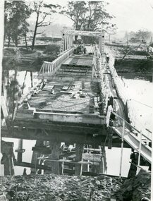 Orbost & District Historical Society
black and white photograph, 1971
... , a joint Country Roads Board — Victorian Railways venture..., a joint Country Roads Board — Victorian Railways venture ...This photograph shows the second major bridge across the Snowy River at Orbost. The current Snowy River bridge is the fourth to provide a crossing to the township of Orbost. The first, in 1891, lasted just two years before it succumbed to flood waters. The bridge in this photograph was built in the 1920s as a road and rail bridge, and was again partly washed away by flood waters in 1934. After the end of the first World War the Victorian Railways considered an extension of the railhead across the river at Orbost, and in 1922 a new timber and steel girder structure, a joint Country Roads Board — Victorian Railways venture, was built and completed at a cost of £41,000 (the steel girders came from the Flinders Street viaduct reconstruction). Subsequently it was decided not to take the railway across the river, and the bridge was only used by road traffic. It was severely battered by floods during its life. and after the devastating 1971 floods was eventually replaced by the current bridge in 1975. (info from Newletter 54N by John Phillips)This is a pictorial record of the flood damage in 1971 when part of the Snowy River Bridge was washed away.A black / white photograph of a bridge which has been damaged by floodwaters. It shows one end has been washed away.orbost-snowy-river-bridge-1971 floods-orbost-1971 -
![W. D. Birrell, Town Clerk [Kew] 1936 -](/media/collectors/550653872162f11fb04854aa/items/5922c01dd0cde9131c35460b/item-media/5c22673821ea6713f45cc993/item-fit-380x285.jpg) Kew Historical Society Inc
Kew Historical Society IncPhotograph, Stuart Tompkins Studios, W. D. Birrell, Town Clerk [Kew] 1936, c.1938
... . Birrell, who had been on the staff of the Country Roads Board..., who had been on the staff of the Country Roads Board after his ...In Kew’s Civic Century (1960), Cr. W.D. Vaughan described William Dickie Birrell M.B.E. (1899-1974) as follows: “Mr. W. D. Birrell, who had been on the staff of the Country Roads Board after his return from active service with the First A.I.F., was appointed assistant town clerk on February 15, 1921. On Mr. Harrison’s retirement he was appointed town clerk and city treasurer, and has given outstanding service. His knowledge of municipal administration has been acknowledged by the Government calling on his services to advise on amendments to the Local Government Act. He is a past president of the Town Clerks Institute, and on the nomination of that body was honoured by Her Majesty the Queen in 1958 with the award of the M.B.E. He still occupies the position and is held in the highest esteem not only by the Kew Council, but also by local government administrators throughout the metropolitan area.” (page 132) He died on 7 May 1974, and his ashes were interred at the Boroondara General Cemetery. This portrait is one of a series of mounted and framed photographic portraits of Mayors and Town Clerks of the former Borough, Town and City of Kew, for the period 1863 to 1969. The portraits were transferred by the City of Kew to the Kew Historical Society in March 1989. A Significance Assessment in 2018, funded by the National Library of Australia confirmed the historic, and often artistic significance of the series. Framed portrait of W. D. Birrell - Town Clerk of the City of Kew from 1936 -. The mounting and framing of the photograph follows a typical layout or style in that it each is framed in dark wood, glazed, and laid down on an inscribed board. The inscription identifies the name of the town clerk and the year/s that he served.W.D. BIRRELL / TOWN CLERK 1938-town clerks - kew (vic), w.d. birrell, photographers - stuart tompkins studios - camberwell (vic), kew (vic.) — municipal collection -
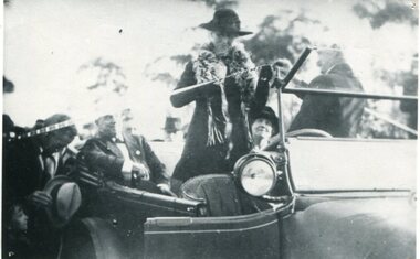 Orbost & District Historical Society
black and white photograph, July 1922
... by the Victorian Railways and the Country Roads Board. Constructed... by the Victorian Railways and the Country Roads Board. Constructed ...The photograph shows Mrs James Cameron cutting the ribbon at the opening of the Orbost Pile Bridge in 1922. The first bridge was officially opened in August, 1893 (ref. S.R.M. 12.8.1893) by Mrs W. Watt, the mother of Councillor Watt, who presided over the opening of the 1922 bridge. This bridge was extensively damaged when a herd of cattle allegedly stampeded over it causing the cable to snap. Even after repairs it became obvious that a new bridge was needed. This second bridge, was built by the Victorian Railways and the Country Roads Board. Constructed at a cost of 35,000 pounds and used second-hand girders from the Flinders Street- Spencer Street viaduct. On July 4 1922 it was officially opened by Mrs James Cameron. Unfortunately, her husband, who had long championed the building of the bridge so that it would be ready for the railway to continue to the border, was too ill to attend the ceremony. In fact, James Cameron died on July 13 after a long and severe illness (ref. S.R.M. 20.7.1922). There is a section of this ribbon in the collection - Registration No. 366.This item is a pictorial record of a significant event in Orbost's history.A black / white photograph of a lady standing up in a motor vehicle cutting a ceremonial ribbonsnowy-river-bridge-orbost cameron-mrs ceremonies -
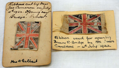 Orbost & District Historical Society
ribbon, 1922
... by the Victorian Railways and the Country Roads Board. Constructed... Railways and the Country Roads Board. Constructed at a cost ...They are both pieces of ribbon used for the opening of the snowy River Bridge on July 4 1922. The ribbon was made to represent the red, white and blue of the British flag. This was the second bridge over the Snowy River. The first bridge was officially opened in August, 1893 (ref. S.R.M. 12.8.1893) by Mrs W. Watt, the mother of Councillor Watt, who presided over the opening of the 1922 bridge. This bridge was extensively damaged when a herd of cattle allegedly stampeded over it causing the cable to snap. Even after repairs it became obvious that a new bridge was needed. This second bridge, was built by the Victorian Railways and the Country Roads Board. Constructed at a cost of 35,000 pounds and used second-hand girders from the Flinders Street- Spencer Street viaduct. On July 4 1922 it was officially opened by Mrs James Cameron. Unfortunately, her husband, who had long championed the building of the bridge so that it would be ready for the railway to continue to the border, was too ill to attend the ceremony. In fact, James Cameron died on July 13 after a long and severe illness (ref. S.R.M. 20.7.1922). Souvenirs kept by enthusiastic spectators like this have helped to preserve the history of an important Orbost event.Two pieces of ribbon in British flag pattern of red, white and blue. These have been pinned onto card with a handwritten description of their history.snowy-river cameron souvenir -
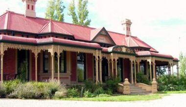 Wodonga & District Historical Society Inc
Photograph - Cambourne House
... by the Country Roads Board and in 2006 by Vic Roads for road works... to the acquisition of land in 1972 by the Country Roads Board and in 2006 ...Cambourne homestead was built by 1903 for Rebecca S. Carkeek, who purchased the property in Wodonga in 1899. Cambourne is situated on the original Wodonga Run which was established in 1836. In 1855 the pre-emptive right of 171 acres of the Wodonga Run was granted and sold the following year. The allotments on which the five-acre Cambourne property developed, were purchased in 1873 and 1876, coinciding with the opening of the Railway from Melbourne. The property was purchased by Rebecca Carkeek in June 1899, wife of William Carkeek, Publican of Wodonga and Shire Councillor. Local architects Gordon and Gordon have been credited with the design of Cambourne. The house at Cambourne was built at some stage between 1900 and 1903 as a large single storey homestead. It was constructed in red brick with corrugated iron roof and encircling verandah. Cambourne is a probable work of architects Gordon and Gordon, it is amongst their best preserved and one of their few surviving buildings in Victoria. Today Cambourne remains on a reduced allotment due to the acquisition of land in 1972 by the Country Roads Board and in 2006 by Vic Roads for road works adjacent to the property.Cambourne, Wodonga is of architectural and historical significance to the State of Victoria.A set of coloured photos depicting Cambourne in Wodonga. Part of a collection documented a heritage listed pioneer home.cambourne wodonga, cambourne homestead wodonga, historic buildings wodonga -
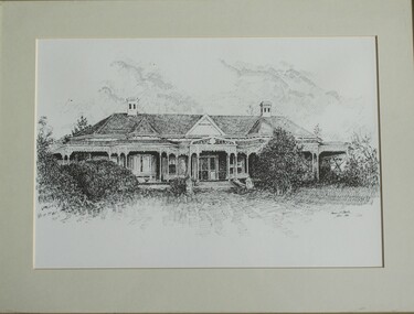 Wodonga & District Historical Society Inc
Drawing - Cambourne House, Kevin P. Clark, 1984
... to the acquisition of land in 1972 by the Country Roads Board and in 2006... to the acquisition of land in 1972 by the Country Roads Board and in 2006 ...Cambourne homestead was built by 1903 for Rebecca S. Carkeek, who purchased the property in Wodonga in 1899. Cambourne is situated on the original Wodonga run which was established in 1836. The township of Belvoir, later renamed as Wodonga. In 1855 the pre-emptive right of 171 acres of the Wodonga run was granted and sold the following year. The allotments on which the five-acre Cambourne property developed, were purchased in 1873 and 1876, coinciding with the opening of the railway from Melbourne. The property was purchased by Rebecca Carkeek in June 1899, wife of William Carkeek, publican of Wodonga and shire councillor. Local architects Gordon and Gordon have been credited with the design of Cambourne. The house at Cambourne was built at some stage between 1900 and 1903 as a large single storey homestead. It was constructed in red brick with corrugated iron roof and encircling verandah. Cambourne is a probable work of architects Gordon and Gordon, it is amongst their best preserved and one of their few surviving buildings in Victoria. Today Cambourne remains on a reduced allotment due to the acquisition of land in 1972 by the Country Roads Board and in 2006 by Vic Roads for road works adjacent to the property.This drawing is significant as a representation of Cambourne in Wodonga. Cambourne is of historical significance due to its links with the early settlement of the district and as an example of closer settlement which occurred in regional centres of the State. Cambourne, Wodonga is also of architectural significance as a largely intact late Victorian style house with elaborate decorative cast iron work and distinctive transverse plan. As a probable work of architects Gordon and Gordon, it is amongst their best preserved and one of their few surviving buildings in Victoria. A framed drawing of historic home, Cambourne in Wodonga. The drawing has been mounted and framed.On bottom right corner" Kevin P. Clark 1984"cambourne wodonga, gordon and gordon architects, historic buildings wodonga, heritage buildings wodonga -
 Wodonga & District Historical Society Inc
Photograph - The Pollard Arch
... Roads Board said the causeway would have to be duplicated... Roads Board said the causeway would have to be duplicated ...The Pollard Archway was named for Charles Pollard, who was the son of an early settler at Bonegilla. Charles Pollard was awarded the MBE for his involvement in community service, he was Secretary of the Murray Valley Shows Association, Shire President in 1926-27, 1945-46 and 1946-47. He was Foundation President of the Wodonga Show Society, and North-Eastern representative of the Dairymen’s Association of Victoria. The arch is 29 metres wide and 15 metres high and consists of two boomerangs coming together to form an archway. Originally spanning across a single carriageway of the Lincoln Causeway, the arch was opened by Princess Alexandra of Kent in 1959 and was built for £1230. When the Country Roads Board said the causeway would have to be duplicated in 1973, a new home was required for the arch. The arch was moved in 1975 to allow for widening of the Lincoln Causeway and spent some time in storage. It was re- erected in Hamilton Smith Drive in 1982 after restoration by the Rotary Club of Belvoir-Wodonga. At the request of the Wodonga Show Society, the arch was moved to the entrance of the showgrounds in 1982. After development of the precinct in 2015, the Pollard Arch was erected on Hamilton Smith Drive Wodonga.These images represent the construction and then subsequent of structure acknowledging the contribution of Councillor Pollard to the community of Wodonga.A series of black and white images documenting the construction and opening of the Pollard arch on the Lincoln Causeway in Wodonga in 1959. A coloured photo from 1965 is also included.wodonga pioneers, pollard family, pollard archway -
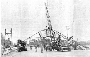
 Kiewa Valley Historical Society
Black and White photograph of Road Making Machinery, Kiewa Road Making, 25/08/1938
... by the Country Roads Board. For the construction work, the Commission... by the Country Roads Board. For the construction work, the Commission ...Construction of the main road from South Tawonga to the Bogong High Plains, to provide access to the construction sites for the new Kiewa Hydro Electric Scheme, was commenced early in 1938, the work being undertaken on behalf of the Commission by the Country Roads Board. For the construction work, the Commission purchased three Caterpillar - model R07 - diesel crawler tractors equipped with Kay Brunerei (Brunner) hydraulically operated trailbuilders (angle dozers). This acquisition resulted from a visit to the United States of America in May, 1937 by the Construction Engineer ( Mr. C.H. Kernot) and Assistant Civil Engineer (Mr. J.F. Douglas) where they saw this relatively new type of equipment in use. With the co-operation of the CRB, the Commission demonstrated the operation of these machines at Fishermen's Bend on 6th April, 1938. They were then sent to Kiewa where they commenced operation towards the end of the month. From South Tawonga, the route led immediately across the Western Branch of the Kiewa River necessitating the construction of a bridge 100 feet long. By the end of 1939, the excavation had been 'opened up' for a distance of 19 1/2 miles (approx. 31 km) and of this length, 10 miles (approx. 16 km) had been surfaced.The purchase and use of this type of mechanical equipment in road making was a huge investment, as prior to this most of the work would have been done manually with the use of picks and shovels. Not only were many months of hard manual labour saved, but a very significant amount of time in providing access to the proposed work sites for the new Kiewa Hydro Scheme. This photo is an excellent reminder of how primitive the early machinery was compared to the present but also represents the forward thinking of the State Electricity Commissions engineers in purchasing such innovative equipment . A black and white photograph showing the type of machinery used for road making in the 1930's. It shows a grader being towed by a caterpillar tractor.On the top left hand corner of the photograph , hand written in black ink is the words 'Kiewa Road Making 25/8/1938'. On the right hand side of the photo has been stamped in blue the Number 1. It has been developed on Velox paper (marked on back of photo) with a gloss finish.road making, state electricity commission, caterpillar tractor, kiewa -
 Kiewa Valley Historical Society
Black and White photograph of Road Making Machinery, Kiewa Road Making 25/08/1938 No. 2, 25/08/1938
... by the Country Roads Board. For the construction work, the Commission... by the Country Roads Board. For the construction work, the Commission ...Construction of the main road from South Tawonga to the Bogong High Plains, to provide access to the construction sites for the new Kiewa Hydro Electric Scheme, was commenced early in 1938, the work being undertaken on behalf of the commission by the Country Roads Board. For the construction work, the Commission purchased three Caterpillar - model R07 - diesel crawler tractors equipped with Kay Brunerei (Brunner) hydraulically operated trailbuilders (angle dozers). This acquisition resulted from a visit to the United States of America in May, 1937 by the Construction Engineer ( Mr. C.H. Kernot) and Assistant Civil Engineer ( Mr. J.F. Douglas) where they saw this relatively new type of equipment in use. With the co-operation of the CRB, the Commission demonstrated the operation of these machines at Fishermen's Bend on 6th April, 1938. They were then sent to Kiewa where they commenced operation towards the end of the month. From South Tawonga, the route let immediately across the Western Branch of the Kiewa River necessitating the construction of a bridge 100 feet long. By the end of 1939, the excavation had been 'opened up' for a distance of 19 1/2 miles (approx. 31 km.) and of this length, 10 miles (approx. 16 km.) had been surfaced. (see KVHS 0328)The purchase of this type of mechanical equipment in road making was a huge investment, as prior to this most of the work would have been done manually with the use of picks and shovels. Not only were many months of hard manual labour saved, but a very significant amount of time in providing access to the proposed work sites for the new Kiewa Hydro Scheme. This photo is an excellent reminder of how primitive the early machinery was compared to the present but also represents the forward thinking of the State Electricity Commissions engineers in purchasing such innovative equipment.A black and white photograph of road making near Mt. Beauty in 1938. Mount Beauty hills can be seen in the background with cleared land for grazing in the fore ground.Hand printed in black ink at the top of the photograph is 'Kiewa Road Making 25/8/1938'. On the right hand corner has been printed the number 2. It has been printed on gloss Velox paper.road making, state electricity commission, caterpillar tractor, kiewa, secv -
 Kiewa Valley Historical Society
Black and White photograph of Road Making Machinery, Kiewa Road Making 25/8/1938(No. 3 in a series of 8), 25/08/1938
... by the Country Roads Board. For the construction work, the Commission... by the Country Roads Board. For the construction work, the Commission ...Construction of the main road from South Tawonga to the Bogong High Plains, to provide access to the construction sites for the new Kiewa Hydro Electric Scheme, was commenced early in 1938, the work being undertaken on behalf of the Commission by the Country Roads Board. For the construction work, the Commission purchased three Caterpillar - model R07 - diesel crawler tractors equipped with Kay Brunerei (Brunner) hydraulically operated trail builders (angle dozers)). This acquisition resulted from a visit to the United States of America in May, 1937 by the Construction Engineer ( Mr. C.H. Kernot) and Assistant Civil Engineer (Mr. J.F. Douglas) where they saw this relatively new type of equipment in use. With the co-operation of the CRB, the Commission demonstrated the operation of these machines at Fishermen's Bend on 6th April, 1938. They were then sent to Kiewa where they commenced operation towards the end of the month. From South Tawonga, the route led immediately across the Western Branch of the Kiewa River necessitating the construction of a bridge 100 feet long. By the end of 1939,the excavation had been 'opened up' for a distance of 19 1/2 miles (approx. 31 km.) and of this length, 10 miles (approx. 16 km) had been surfaced.The purchase and use of this type of mechanical equipment in road making was a huge investment, as prior to this most of the work would have been done manually with the use of picks and shovels. Not only were many months of hard manual labour saved, but a very significant amount of time in providing access to the proposed work sites for the new Kiewa Hydro Scheme. This photo is an excellent reminder of how primitive the early machinery was compared to the present but also represents the forward thinking of the State Electricity Commission's Engineers in purchasing such new and innovative equipment.A black and white photograph of a Caterpillar diesel crawler tractor and a hydraulically operated trailbuilder (angle dozer) making a road in the Mt. Beauty area.Hand written in black ink in the top left hand corner are the words "Kiewa Road Making 25/8/1938". On the upper right hand of the photograph has been stamped the number 3. On the back is stamped the word 'Velox' severaly times, which is the make of the photograhic paper. roadmaking, caterpillar tractor, kiewa, state electricity commission -
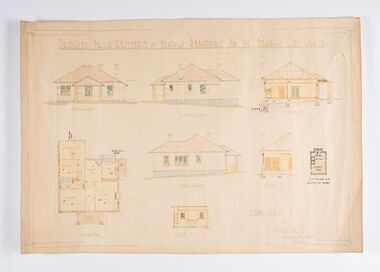 City of Greater Bendigo - Civic Collection
Work on paper - Architectural Drawing, City of Bendigo, Proposed Brick Residence at Bendigo Abbatoirs (sic) for the Bendigo City Council, Not dated
... the buildings were acquired by the Country Roads Board in 1945... acquired by the Country Roads Board in 1945, a substantial ...Situated at 47 Lansell Street, Bendigo, the original 1911-12 Charles D'Ebro designed brick Bendigo Municipal Abattoir, comprising twin slaughter and hanging rooms for cattle, sheep and pigs, and two smaller ancillary brick buildings. After the buildings were acquired by the Country Roads Board in 1945, a substantial but sympathetic addition was made to the south-eastern end of the old cattle abattoir. The abattoir is significant for historic, architectural and technical reasons at a state level. as a rare surviving municipal abattoir, and represents the development of hygienic slaughtering through municipal regulations, thus improving standards of public health in Victoria. It is historically significant to the City of Greater Bendigo as a key to the primary production industry that centred on this precinct from the 1860s to the mid 1990s; they are an important surviving component of one of the largest regional livestock markets in Victoria. D'Ebro was critically influential in the development of industrial and in particular meat processing buildings, designing major freezing works and abattoirs throughout Victoria and Australia.(Source, National Trust Database). The Bendigo facility finally closed in 1945, when all slaughtering for local consumption passed to a joint export and local slaughtering facility at the Bendigo Inland Meat Authority. Ink, pen, pencil and watercolour architectural drawing for the proposed brick residence at Bendigo abattoirs. Proposed Brick Residence at Bendigo Abbatoirs (sic) For The Bendigo City Council. / Front Elevation / Easter Elevation / Section A. D. / Ground Plan / Wester Elevation / Section C.D. / Section I. P. ? Existing Building to be / Converted into Laundry ? Scale 1/8" to 1 FT / Geo. Austen Architect / Commonwealth Bank Chambers / Bendigocity of greater bendigo commerce, charles d'ebro -
 Bendigo Historical Society Inc.
Newspaper - LONG GULLY HISTORY GROUP COLLECTION: EAGLEHAWK ROAD - LONG GULLY
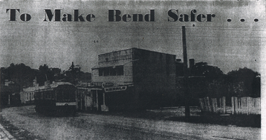
... -alignment of the Long Gully bend by the Country Roads Board... by the Country Roads Board. The Board declared an alignment some years ...Copy of a newspaper photo titled To Make Bend Safer. Photo shows a tram passing a newsagent shop. On the right is a dilapidated picket fence. Allso hand written paper on one side is: Approx 1966 ? One of the last trams No 18 to run up Main Street of Long Gully (Bond Street) Now known as Eaglehawk Road. On Left - Post Office - now Gents Hairdresser & Rose of No 3 Australia Hotel. On Right - Les & Marie Norris Newsagency & Mixed Business. 2 story building was Commercial Hotel. No 26 Tram was the last to run between Bendigo, Long Gully & Eaglehawk. Still running as a Tourist. Donated by Alan Crossley. tram in Bendigo 1987 1985. On the other side is written: One building has already been demolished and the proprietor of the Newsagency & mixed business Mr. L W Norris, will also demolish and rebuild further back from the road in preparation for eventual re-alignment of the Long Gully bend by the Country Roads Board. The Board declared an alignment some years ago for the corner - a severe traffic hazard - but, the assistant Divisional Engineer, Mr G Marshallsea said yesterday the Board had no immediate plans. These were one of the last Trams to run through Long Gully.bendigo, history, long gully history group, the long gully history group - eaglehawk road - long gully -
 Eltham District Historical Society Inc
Negative - Photograph, Mail coach en route to Hurstbridge, c.1922
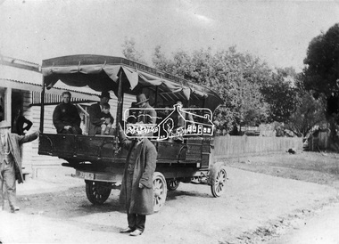
... was refused by the Country Roads Board mid 1930 as his bus... was refused by the Country Roads Board mid 1930 as his bus ...Coach with flaps takes aboard passengers. It travelled between Kinglake and Hurstbridge. The vehicle has advertising on the side indicating: W. BODY. HURSTBRIDGE bread and pastry. The Advertiser on 15 Sep 1922 has a display advertisement on page 2 indicating that Hurstbridge bakery 'W. Body wishes to notify the Public of Hurstbridge and surrounding district that he has purchased Mr Oliver's business'. The Advertiser, Friday 10 November 1922, page 2: Mr J. D. Chalmers, who runs the motor service from Hurstbridge to Kinglake, has just had a large, body built on a two-ton motor, which will be serviceable for either 25 passengers or general goods. The work was entrusted to Mr. D.G. Graham, motor and coach builder, Hurstbridge, who completed it within a month, the finish, painting, etc.. being quite up to the standard of a city shop. The mail coach operated the route between Kinglake and Hurstbridge motor route, on which Mr. Sharpe had pioneered and run a motor mail route with a bus which carried 20 passengers, for many years but Sharpe's license for his motor bus was refused by the Country Roads Board mid 1930 as his bus was considered too large . In February 1935, Mr Sharpe was granted a license to carry passengers between Hurstbridge and Kinglake and Mr Kell between Kinglake and Hurstbridge. In 1936 the mail contract from Heidelberg to Knglake was via car and members of the community were concerned that there was no further any conveyance of passengers from Hurstbridge to Kinglake.This photo forms part of a collection of photographs gathered by the Shire of Eltham for their centenary project book,"Pioneers and Painters: 100 years of the Shire of Eltham" by Alan Marshall (1971). The collection of over 500 images is held in partnership between Eltham District Historical Society and Yarra Plenty Regional Library (Eltham Library) and is now formally known as 'The Shire of Eltham Pioneers Photograph Collection.' It is significant in being the first community sourced collection representing the places and people of the Shire's first one hundred years.Digital image 4 x 5 inch B&W Neg 9 x 12.5 cm B&W printsepp, shire of eltham pioneers photograph collection, kinglake, mail coach, w. body, public transport, bus, bus travel, hurstbridge, pioneers and painters -
 Eltham District Historical Society Inc
Photograph, Looking north across the Fitzsimons Lane Bridge over Yarra River between Eltham and Templestowe, c.1985, 1985c
... THEM EXPLORING Without any fanfares, Country Roads Board... THEM EXPLORING Without any fanfares, Country Roads Board ...Turnoff to Candlebark Park on right. The bridge over the Yarra River was initially opened September 22nd, 1961. Newspaper reports at the time of opening stated it linked Bolton Street, Eltham, with Fitzsimons Lane, Templestowe. In 1955 the Country Roads Board (CRB) produced survey plans that showed proposed land acquisition for the future bridge and road approaches. The 1955 plan shows that it was proposed to connect Fitzsimons Lane with Bolton Street in Eltham by a diagonal road across the river. The road connection would then continue along Bolton Street to Main Road. Prior to construction of the bridge the CRB modified the proposal significantly so that there was a new road parallel with Bolton Street and then curving to join Main Road at what was then its intersection with Old Eltham Road. This involved significantly more land acquisition and altered the pattern of land subdivision through this corridor. Initially the new road was just a single two-way carriageway as it would have required a significant widening of the cutting on the Shire of Eltham side of the river. The road was officially un-named but was known locally as the Eltham-Templestowe Road. The 1966 Melway street directory and other 1960s editions also listed the road as the Eltham-Templestowe Road. In December 1970, Eltham Shire Council, in pursuance of the provisions of the Local Government Act, named it Templestowe Road. The road was renamed Fitzsimons Lane around 1984 in conformity with the section south of the river. In 1991 a new bridge was built to the west of the original bridge. Fitzsimons Lane was widened to four traffic lanes although on the Eltham side this was done within the limits of the existing cutting. NEW BRIDGE STARTS THEM EXPLORING Without any fanfares, Country Roads Board workmen on Friday afternoon put the finishing touches to the approaches, removed the barricades, and let the traffic roll over the new Yarra bridge linking Bolton Street, Eltham, with Fitzsimons Lane, Templestowe. Over the week-end many “bridge watchers” who were making one of their periodic inspections of the progress on the new bridge found to their surprise that they could drive over it, so that people who had gone for a run out to Eltham suddenly found themselves wandering through Templestowe and Doncaster. By Monday the word of the bridge’s opening had got around sufficiently for many regular travellers to the city from Eltham and beyond to vary the monotony by going to town via Templestowe and Kew instead of through Heidelberg. They were surprised at the distances – about 3 ½ miles from Eltham to Templestowe, 6 miles from Eltham Shire hall to the Lower Heidelberg Road-Banksia Street intersection. NEW NEIGHBOURS For people on both sides of the river, the new bridge has turned distant friends into near neighbours. A Greensborough man on Sunday took 35 minutes to reach the home of a friend in East Doncaster, but the return trip over the new bridge took only 17 minutes. It will be some time yet before most people work out the possibilities in shorter and quicker trips form the north-eastern areas to the eastern and south-eastern suburbs. The coming of the warmer months will soon teach many, though the short cuts to Peninsular beaches and eastern suburban drive-ins. And before very long it is likely there will be a Tramways bus running from Templestowe to Eltham station. NEW BRIDGE STARTS THEM EXPLORING (1961, September 27). The Diamond Valley News (News clipping held in SEA_74-1_047) The previously un-named road between Main Road and Yarra River, Eltham South, east of Bolton Street was named Templestowe Road, December 15, 1970 NAMING OF STREETS AND ROADS. (1970, December 15). The Diamond Valley News (News clipping held in SEA_74-2_022)Colour photographinfrastructure, shire of eltham infrastructure, bridge, fitzsimons lane bridge, yarra river, candlebark park, red nose day -
 Eltham District Historical Society Inc
Photograph, Fitzsimons Lane Bridge over Yarra River between Eltham and Templestowe
... , Templestowe. In 1955 the Country Roads Board (CRB) produced survey..., Templestowe. In 1955 the Country Roads Board (CRB) produced survey ...The bridge over the Yarra River was initially opened September 22nd, 1961. Newspaper reports at the time of opening stated it linked Bolton Street, Eltham, with Fitzsimons Lane, Templestowe. In 1955 the Country Roads Board (CRB) produced survey plans that showed proposed land acquisition for the future bridge and road approaches. The 1955 plan shows that it was proposed to connect Fitzsimons Lane with Bolton Street in Eltham by a diagonal road across the river. The road connection would then continue along Bolton Street to Main Road. Prior to construction of the bridge the CRB modified the proposal significantly so that there was a new road parallel with Bolton Street and then curving to join Main Road at what was then its intersection with Old Eltham Road. This involved significantly more land acquisition and altered the pattern of land subdivision through this corridor. Initially the new road was just a single two-way carriageway as it would have required a significant widening of the cutting on the Shire of Eltham side of the river. The road was officially un-named but was known locally as the Eltham-Templestowe Road. The 1966 Melway street directory and other 1960s editions also listed the road as the Eltham-Templestowe Road. In December 1970, Eltham Shire Council, in pursuance of the provisions of the Local Government Act, named it Templestowe Road. The road was renamed Fitzsimons Lane around 1984 in conformity with the section south of the river. In 1991 a new bridge was built to the west of the original bridge. Fitzsimons Lane was widened to four traffic lanes although on the Eltham side this was done within the limits of the existing cutting. NEW BRIDGE STARTS THEM EXPLORING Without any fanfares, Country Roads Board workmen on Friday afternoon put the finishing touches to the approaches, removed the barricades, and let the traffic roll over the new Yarra bridge linking Bolton Street, Eltham, with Fitzsimons Lane, Templestowe. Over the week-end many “bridge watchers” who were making one of their periodic inspections of the progress on the new bridge found to their surprise that they could drive over it, so that people who had gone for a run out to Eltham suddenly found themselves wandering through Templestowe and Doncaster. By Monday the word of the bridge’s opening had got around sufficiently for many regular travellers to the city from Eltham and beyond to vary the monotony by going to town via Templestowe and Kew instead of through Heidelberg. They were surprised at the distances – about 3 ½ miles from Eltham to Templestowe, 6 miles from Eltham Shire hall to the Lower Heidelberg Road-Banksia Street intersection. NEW NEIGHBOURS For people on both sides of the river, the new bridge has turned distant friends into near neighbours. A Greensborough man on Sunday took 35 minutes to reach the home of a friend in East Doncaster, but the return trip over the new bridge took only 17 minutes. It will be some time yet before most people work out the possibilities in shorter and quicker trips form the north-eastern areas to the eastern and south-eastern suburbs. The coming of the warmer months will soon teach many, though the short cuts to Peninsular beaches and eastern suburban drive-ins. And before very long it is likely there will be a Tramways bus running from Templestowe to Eltham station. NEW BRIDGE STARTS THEM EXPLORING (1961, September 27). The Diamond Valley News (News clipping held in SEA_74-1_047) The previously un-named road between Main Road and Yarra River, Eltham South, east of Bolton Street was named Templestowe Road, December 15, 1970 NAMING OF STREETS AND ROADS. (1970, December 15). The Diamond Valley News (News clipping held in SEA_74-2_022)Black and white photographinfrastructure, shire of eltham infrastructure, bridge, fitzsimons lane bridge, yarra river -
 Eltham District Historical Society Inc
Photograph, Looking south across the Fitzsimons Lane Bridge over Yarra River between Eltham and Templestowe
... , Templestowe. In 1955 the Country Roads Board (CRB) produced survey..., Templestowe. In 1955 the Country Roads Board (CRB) produced survey ...The bridge over the Yarra River was initially opened September 22nd, 1961. Newspaper reports at the time of opening stated it linked Bolton Street, Eltham, with Fitzsimons Lane, Templestowe. In 1955 the Country Roads Board (CRB) produced survey plans that showed proposed land acquisition for the future bridge and road approaches. The 1955 plan shows that it was proposed to connect Fitzsimons Lane with Bolton Street in Eltham by a diagonal road across the river. The road connection would then continue along Bolton Street to Main Road. Prior to construction of the bridge the CRB modified the proposal significantly so that there was a new road parallel with Bolton Street and then curving to join Main Road at what was then its intersection with Old Eltham Road. This involved significantly more land acquisition and altered the pattern of land subdivision through this corridor. Initially the new road was just a single two-way carriageway as it would have required a significant widening of the cutting on the Shire of Eltham side of the river. The road was officially un-named but was known locally as the Eltham-Templestowe Road. The 1966 Melway street directory and other 1960s editions also listed the road as the Eltham-Templestowe Road. In December 1970, Eltham Shire Council, in pursuance of the provisions of the Local Government Act, named it Templestowe Road. The road was renamed Fitzsimons Lane around 1984 in conformity with the section south of the river. In 1991 a new bridge was built to the west of the original bridge. Fitzsimons Lane was widened to four traffic lanes although on the Eltham side this was done within the limits of the existing cutting. NEW BRIDGE STARTS THEM EXPLORING Without any fanfares, Country Roads Board workmen on Friday afternoon put the finishing touches to the approaches, removed the barricades, and let the traffic roll over the new Yarra bridge linking Bolton Street, Eltham, with Fitzsimons Lane, Templestowe. Over the week-end many “bridge watchers” who were making one of their periodic inspections of the progress on the new bridge found to their surprise that they could drive over it, so that people who had gone for a run out to Eltham suddenly found themselves wandering through Templestowe and Doncaster. By Monday the word of the bridge’s opening had got around sufficiently for many regular travellers to the city from Eltham and beyond to vary the monotony by going to town via Templestowe and Kew instead of through Heidelberg. They were surprised at the distances – about 3 ½ miles from Eltham to Templestowe, 6 miles from Eltham Shire hall to the Lower Heidelberg Road-Banksia Street intersection. NEW NEIGHBOURS For people on both sides of the river, the new bridge has turned distant friends into near neighbours. A Greensborough man on Sunday took 35 minutes to reach the home of a friend in East Doncaster, but the return trip over the new bridge took only 17 minutes. It will be some time yet before most people work out the possibilities in shorter and quicker trips form the north-eastern areas to the eastern and south-eastern suburbs. The coming of the warmer months will soon teach many, though the short cuts to Peninsular beaches and eastern suburban drive-ins. And before very long it is likely there will be a Tramways bus running from Templestowe to Eltham station. NEW BRIDGE STARTS THEM EXPLORING (1961, September 27). The Diamond Valley News (News clipping held in SEA_74-1_047) The previously un-named road between Main Road and Yarra River, Eltham South, east of Bolton Street was named Templestowe Road, December 15, 1970 NAMING OF STREETS AND ROADS. (1970, December 15). The Diamond Valley News (News clipping held in SEA_74-2_022)Black and white photographinfrastructure, shire of eltham infrastructure, bridge, fitzsimons lane bridge, yarra river -
 Eltham District Historical Society Inc
Photograph, Fitzsimons Lane Bridge over Yarra River between Eltham and Templestowe
... , Templestowe. In 1955 the Country Roads Board (CRB) produced survey..., Templestowe. In 1955 the Country Roads Board (CRB) produced survey ...The bridge over the Yarra River was initially opened September 22nd, 1961. Newspaper reports at the time of opening stated it linked Bolton Street, Eltham, with Fitzsimons Lane, Templestowe. In 1955 the Country Roads Board (CRB) produced survey plans that showed proposed land acquisition for the future bridge and road approaches. The 1955 plan shows that it was proposed to connect Fitzsimons Lane with Bolton Street in Eltham by a diagonal road across the river. The road connection would then continue along Bolton Street to Main Road. Prior to construction of the bridge the CRB modified the proposal significantly so that there was a new road parallel with Bolton Street and then curving to join Main Road at what was then its intersection with Old Eltham Road. This involved significantly more land acquisition and altered the pattern of land subdivision through this corridor. Initially the new road was just a single two-way carriageway as it would have required a significant widening of the cutting on the Shire of Eltham side of the river. The road was officially un-named but was known locally as the Eltham-Templestowe Road. The 1966 Melway street directory and other 1960s editions also listed the road as the Eltham-Templestowe Road. In December 1970, Eltham Shire Council, in pursuance of the provisions of the Local Government Act, named it Templestowe Road. The road was renamed Fitzsimons Lane around 1984 in conformity with the section south of the river. In 1991 a new bridge was built to the west of the original bridge. Fitzsimons Lane was widened to four traffic lanes although on the Eltham side this was done within the limits of the existing cutting. NEW BRIDGE STARTS THEM EXPLORING Without any fanfares, Country Roads Board workmen on Friday afternoon put the finishing touches to the approaches, removed the barricades, and let the traffic roll over the new Yarra bridge linking Bolton Street, Eltham, with Fitzsimons Lane, Templestowe. Over the week-end many “bridge watchers” who were making one of their periodic inspections of the progress on the new bridge found to their surprise that they could drive over it, so that people who had gone for a run out to Eltham suddenly found themselves wandering through Templestowe and Doncaster. By Monday the word of the bridge’s opening had got around sufficiently for many regular travellers to the city from Eltham and beyond to vary the monotony by going to town via Templestowe and Kew instead of through Heidelberg. They were surprised at the distances – about 3 ½ miles from Eltham to Templestowe, 6 miles from Eltham Shire hall to the Lower Heidelberg Road-Banksia Street intersection. NEW NEIGHBOURS For people on both sides of the river, the new bridge has turned distant friends into near neighbours. A Greensborough man on Sunday took 35 minutes to reach the home of a friend in East Doncaster, but the return trip over the new bridge took only 17 minutes. It will be some time yet before most people work out the possibilities in shorter and quicker trips form the north-eastern areas to the eastern and south-eastern suburbs. The coming of the warmer months will soon teach many, though the short cuts to Peninsular beaches and eastern suburban drive-ins. And before very long it is likely there will be a Tramways bus running from Templestowe to Eltham station. NEW BRIDGE STARTS THEM EXPLORING (1961, September 27). The Diamond Valley News (News clipping held in SEA_74-1_047) The previously un-named road between Main Road and Yarra River, Eltham South, east of Bolton Street was named Templestowe Road, December 15, 1970 NAMING OF STREETS AND ROADS. (1970, December 15). The Diamond Valley News (News clipping held in SEA_74-2_022)Black and white photographinfrastructure, shire of eltham infrastructure, bridge, fitzsimons lane bridge, yarra river -
 Eltham District Historical Society Inc
Photograph, Russell Yeoman, Fitzsimons Lane Bridge over Yarra River between Eltham and Templestowe, c.1970, 1970c
... , Templestowe. In 1955 the Country Roads Board (CRB) produced survey..., Templestowe. In 1955 the Country Roads Board (CRB) produced survey ...The bridge over the Yarra River was initially opened September 22nd, 1961. Newspaper reports at the time of opening stated it linked Bolton Street, Eltham, with Fitzsimons Lane, Templestowe. In 1955 the Country Roads Board (CRB) produced survey plans that showed proposed land acquisition for the future bridge and road approaches. The 1955 plan shows that it was proposed to connect Fitzsimons Lane with Bolton Street in Eltham by a diagonal road across the river. The road connection would then continue along Bolton Street to Main Road. Prior to construction of the bridge the CRB modified the proposal significantly so that there was a new road parallel with Bolton Street and then curving to join Main Road at what was then its intersection with Old Eltham Road. This involved significantly more land acquisition and altered the pattern of land subdivision through this corridor. Initially the new road was just a single two-way carriageway as it would have required a significant widening of the cutting on the Shire of Eltham side of the river. The road was officially un-named but was known locally as the Eltham-Templestowe Road. The 1966 Melway street directory and other 1960s editions also listed the road as the Eltham-Templestowe Road. In December 1970, Eltham Shire Council, in pursuance of the provisions of the Local Government Act, named it Templestowe Road. The road was renamed Fitzsimons Lane around 1984 in conformity with the section south of the river. In 1991 a new bridge was built to the west of the original bridge. Fitzsimons Lane was widened to four traffic lanes although on the Eltham side this was done within the limits of the existing cutting. NEW BRIDGE STARTS THEM EXPLORING Without any fanfares, Country Roads Board workmen on Friday afternoon put the finishing touches to the approaches, removed the barricades, and let the traffic roll over the new Yarra bridge linking Bolton Street, Eltham, with Fitzsimons Lane, Templestowe. Over the week-end many “bridge watchers” who were making one of their periodic inspections of the progress on the new bridge found to their surprise that they could drive over it, so that people who had gone for a run out to Eltham suddenly found themselves wandering through Templestowe and Doncaster. By Monday the word of the bridge’s opening had got around sufficiently for many regular travellers to the city from Eltham and beyond to vary the monotony by going to town via Templestowe and Kew instead of through Heidelberg. They were surprised at the distances – about 3 ½ miles from Eltham to Templestowe, 6 miles from Eltham Shire hall to the Lower Heidelberg Road-Banksia Street intersection. NEW NEIGHBOURS For people on both sides of the river, the new bridge has turned distant friends into near neighbours. A Greensborough man on Sunday took 35 minutes to reach the home of a friend in East Doncaster, but the return trip over the new bridge took only 17 minutes. It will be some time yet before most people work out the possibilities in shorter and quicker trips form the north-eastern areas to the eastern and south-eastern suburbs. The coming of the warmer months will soon teach many, though the short cuts to Peninsular beaches and eastern suburban drive-ins. And before very long it is likely there will be a Tramways bus running from Templestowe to Eltham station. NEW BRIDGE STARTS THEM EXPLORING (1961, September 27). The Diamond Valley News (News clipping held in SEA_74-1_047) The previously un-named road between Main Road and Yarra River, Eltham South, east of Bolton Street was named Templestowe Road, December 15, 1970 NAMING OF STREETS AND ROADS. (1970, December 15). The Diamond Valley News (News clipping held in SEA_74-2_022)Roll of 35mm black and white negative film, 4 of 7 stripsIlford HP4bridge, bridges, fitzsimons lane bridge, infrastructure, shire of eltham infrastructure, yarra river -
 Eltham District Historical Society Inc
Photograph, Fitzsimons Lane Bridge over Yarra River between Eltham and Templestowe, c.1966, 1966c
... , Templestowe. In 1955 the Country Roads Board (CRB) produced survey..., Templestowe. In 1955 the Country Roads Board (CRB) produced survey ...The bridge over the Yarra River was initially opened September 22nd, 1961. Newspaper reports at the time of opening stated it linked Bolton Street, Eltham, with Fitzsimons Lane, Templestowe. In 1955 the Country Roads Board (CRB) produced survey plans that showed proposed land acquisition for the future bridge and road approaches. The 1955 plan shows that it was proposed to connect Fitzsimons Lane with Bolton Street in Eltham by a diagonal road across the river. The road connection would then continue along Bolton Street to Main Road. Prior to construction of the bridge the CRB modified the proposal significantly so that there was a new road parallel with Bolton Street and then curving to join Main Road at what was then its intersection with Old Eltham Road. This involved significantly more land acquisition and altered the pattern of land subdivision through this corridor. Initially the new road was just a single two-way carriageway as it would have required a significant widening of the cutting on the Shire of Eltham side of the river. The road was officially un-named but was known locally as the Eltham-Templestowe Road. The 1966 Melway street directory and other 1960s editions also listed the road as the Eltham-Templestowe Road. In December 1970, Eltham Shire Council, in pursuance of the provisions of the Local Government Act, named it Templestowe Road. The road was renamed Fitzsimons Lane around 1984 in conformity with the section south of the river. In 1991 a new bridge was built to the west of the original bridge. Fitzsimons Lane was widened to four traffic lanes although on the Eltham side this was done within the limits of the existing cutting. NEW BRIDGE STARTS THEM EXPLORING Without any fanfares, Country Roads Board workmen on Friday afternoon put the finishing touches to the approaches, removed the barricades, and let the traffic roll over the new Yarra bridge linking Bolton Street, Eltham, with Fitzsimons Lane, Templestowe. Over the week-end many “bridge watchers” who were making one of their periodic inspections of the progress on the new bridge found to their surprise that they could drive over it, so that people who had gone for a run out to Eltham suddenly found themselves wandering through Templestowe and Doncaster. By Monday the word of the bridge’s opening had got around sufficiently for many regular travellers to the city from Eltham and beyond to vary the monotony by going to town via Templestowe and Kew instead of through Heidelberg. They were surprised at the distances – about 3 ½ miles from Eltham to Templestowe, 6 miles from Eltham Shire hall to the Lower Heidelberg Road-Banksia Street intersection. NEW NEIGHBOURS For people on both sides of the river, the new bridge has turned distant friends into near neighbours. A Greensborough man on Sunday took 35 minutes to reach the home of a friend in East Doncaster, but the return trip over the new bridge took only 17 minutes. It will be some time yet before most people work out the possibilities in shorter and quicker trips form the north-eastern areas to the eastern and south-eastern suburbs. The coming of the warmer months will soon teach many, though the short cuts to Peninsular beaches and eastern suburban drive-ins. And before very long it is likely there will be a Tramways bus running from Templestowe to Eltham station. NEW BRIDGE STARTS THEM EXPLORING (1961, September 27). The Diamond Valley News (News clipping held in SEA_74-1_047) The previously un-named road between Main Road and Yarra River, Eltham South, east of Bolton Street was named Templestowe Road, December 15, 1970 NAMING OF STREETS AND ROADS. (1970, December 15). The Diamond Valley News (News clipping held in SEA_74-2_022)Black and white photographManufacturer's marks: Polaroid, Batch #J62K181 (Sep 1966).infrastructure, shire of eltham infrastructure, bridge, fitzsimons lane bridge, polaroid, yarra river -
 Eltham District Historical Society Inc
Photograph, Fitzsimons Lane Bridge over Yarra River between Eltham and Templestowe
... , Templestowe. In 1955 the Country Roads Board (CRB) produced survey..., Templestowe. In 1955 the Country Roads Board (CRB) produced survey ...The bridge over the Yarra River was initially opened September 22nd, 1961. Newspaper reports at the time of opening stated it linked Bolton Street, Eltham, with Fitzsimons Lane, Templestowe. In 1955 the Country Roads Board (CRB) produced survey plans that showed proposed land acquisition for the future bridge and road approaches. The 1955 plan shows that it was proposed to connect Fitzsimons Lane with Bolton Street in Eltham by a diagonal road across the river. The road connection would then continue along Bolton Street to Main Road. Prior to construction of the bridge the CRB modified the proposal significantly so that there was a new road parallel with Bolton Street and then curving to join Main Road at what was then its intersection with Old Eltham Road. This involved significantly more land acquisition and altered the pattern of land subdivision through this corridor. Initially the new road was just a single two-way carriageway as it would have required a significant widening of the cutting on the Shire of Eltham side of the river. The road was officially un-named but was known locally as the Eltham-Templestowe Road. The 1966 Melway street directory and other 1960s editions also listed the road as the Eltham-Templestowe Road. In December 1970, Eltham Shire Council, in pursuance of the provisions of the Local Government Act, named it Templestowe Road. The road was renamed Fitzsimons Lane around 1984 in conformity with the section south of the river. In 1991 a new bridge was built to the west of the original bridge. Fitzsimons Lane was widened to four traffic lanes although on the Eltham side this was done within the limits of the existing cutting. NEW BRIDGE STARTS THEM EXPLORING Without any fanfares, Country Roads Board workmen on Friday afternoon put the finishing touches to the approaches, removed the barricades, and let the traffic roll over the new Yarra bridge linking Bolton Street, Eltham, with Fitzsimons Lane, Templestowe. Over the week-end many “bridge watchers” who were making one of their periodic inspections of the progress on the new bridge found to their surprise that they could drive over it, so that people who had gone for a run out to Eltham suddenly found themselves wandering through Templestowe and Doncaster. By Monday the word of the bridge’s opening had got around sufficiently for many regular travellers to the city from Eltham and beyond to vary the monotony by going to town via Templestowe and Kew instead of through Heidelberg. They were surprised at the distances – about 3 ½ miles from Eltham to Templestowe, 6 miles from Eltham Shire hall to the Lower Heidelberg Road-Banksia Street intersection. NEW NEIGHBOURS For people on both sides of the river, the new bridge has turned distant friends into near neighbours. A Greensborough man on Sunday took 35 minutes to reach the home of a friend in East Doncaster, but the return trip over the new bridge took only 17 minutes. It will be some time yet before most people work out the possibilities in shorter and quicker trips form the north-eastern areas to the eastern and south-eastern suburbs. The coming of the warmer months will soon teach many, though the short cuts to Peninsular beaches and eastern suburban drive-ins. And before very long it is likely there will be a Tramways bus running from Templestowe to Eltham station. NEW BRIDGE STARTS THEM EXPLORING (1961, September 27). The Diamond Valley News (News clipping held in SEA_74-1_047) The previously un-named road between Main Road and Yarra River, Eltham South, east of Bolton Street was named Templestowe Road, December 15, 1970 NAMING OF STREETS AND ROADS. (1970, December 15). The Diamond Valley News (News clipping held in SEA_74-2_022)Black and white photographinfrastructure, shire of eltham infrastructure, bridge, fitzsimons lane bridge, yarra river -
 Eltham District Historical Society Inc
Photograph, Fitzsimons Lane Bridge over Yarra River between Eltham and Templestowe
... , Templestowe. In 1955 the Country Roads Board (CRB) produced survey..., Templestowe. In 1955 the Country Roads Board (CRB) produced survey ...The bridge over the Yarra River was initially opened September 22nd, 1961. Newspaper reports at the time of opening stated it linked Bolton Street, Eltham, with Fitzsimons Lane, Templestowe. In 1955 the Country Roads Board (CRB) produced survey plans that showed proposed land acquisition for the future bridge and road approaches. The 1955 plan shows that it was proposed to connect Fitzsimons Lane with Bolton Street in Eltham by a diagonal road across the river. The road connection would then continue along Bolton Street to Main Road. Prior to construction of the bridge the CRB modified the proposal significantly so that there was a new road parallel with Bolton Street and then curving to join Main Road at what was then its intersection with Old Eltham Road. This involved significantly more land acquisition and altered the pattern of land subdivision through this corridor. Initially the new road was just a single two-way carriageway as it would have required a significant widening of the cutting on the Shire of Eltham side of the river. The road was officially un-named but was known locally as the Eltham-Templestowe Road. The 1966 Melway street directory and other 1960s editions also listed the road as the Eltham-Templestowe Road. In December 1970, Eltham Shire Council, in pursuance of the provisions of the Local Government Act, named it Templestowe Road. The road was renamed Fitzsimons Lane around 1984 in conformity with the section south of the river. In 1991 a new bridge was built to the west of the original bridge. Fitzsimons Lane was widened to four traffic lanes although on the Eltham side this was done within the limits of the existing cutting. NEW BRIDGE STARTS THEM EXPLORING Without any fanfares, Country Roads Board workmen on Friday afternoon put the finishing touches to the approaches, removed the barricades, and let the traffic roll over the new Yarra bridge linking Bolton Street, Eltham, with Fitzsimons Lane, Templestowe. Over the week-end many “bridge watchers” who were making one of their periodic inspections of the progress on the new bridge found to their surprise that they could drive over it, so that people who had gone for a run out to Eltham suddenly found themselves wandering through Templestowe and Doncaster. By Monday the word of the bridge’s opening had got around sufficiently for many regular travellers to the city from Eltham and beyond to vary the monotony by going to town via Templestowe and Kew instead of through Heidelberg. They were surprised at the distances – about 3 ½ miles from Eltham to Templestowe, 6 miles from Eltham Shire hall to the Lower Heidelberg Road-Banksia Street intersection. NEW NEIGHBOURS For people on both sides of the river, the new bridge has turned distant friends into near neighbours. A Greensborough man on Sunday took 35 minutes to reach the home of a friend in East Doncaster, but the return trip over the new bridge took only 17 minutes. It will be some time yet before most people work out the possibilities in shorter and quicker trips form the north-eastern areas to the eastern and south-eastern suburbs. The coming of the warmer months will soon teach many, though the short cuts to Peninsular beaches and eastern suburban drive-ins. And before very long it is likely there will be a Tramways bus running from Templestowe to Eltham station. NEW BRIDGE STARTS THEM EXPLORING (1961, September 27). The Diamond Valley News (News clipping held in SEA_74-1_047) The previously un-named road between Main Road and Yarra River, Eltham South, east of Bolton Street was named Templestowe Road, December 15, 1970 NAMING OF STREETS AND ROADS. (1970, December 15). The Diamond Valley News (News clipping held in SEA_74-2_022)Black and white photographinfrastructure, shire of eltham infrastructure, bridge, fitzsimons lane bridge, yarra river -
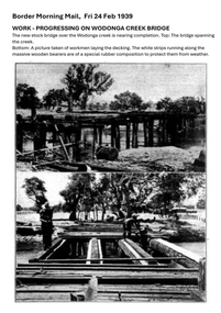 Wodonga & District Historical Society Inc
Photograph - Wodonga Creek Stock Bridge Collection
... by the Country Roads Board in 1939. The date was recorded on a small... by the Country Roads Board in 1939. The date was recorded on a small ...The Wodonga Creek Stock Bridge was constructed by the Country Roads Board in 1939. The date was recorded on a small plaque attached to one of the trestles. The bridge is an important reminder of one of the industries Wodonga was built on — cattle. It was constructed to develop a new stock route between Albury and Wodonga which would direct cattle away from the main bitumen roads and traffic bridges to the Wodonga Saleyards, where thousands of sheep and cattle were sold each month. It is a moderately tall timber trestle road bridge consisting of nine spans, with a deck length of 76 metres and deck width of 4.5 metres, and a maximum span length of 8.5 metres. The substantial timber deck featured decking laid horizontally and longitudinal running planks laid on top of it. The bridge also has timber side safety rails to discourage livestock from straying over the side. The bridge also became the centre of summer social activity for the young people of Wodonga as the area became a gazetted swimming area before the Wodonga Swimming Pool was constructed in 1959. In 1980 the Wodonga Saleyards were relocated to Bandiana to the east of the city. This meant that Wodonga Creek Stock Bridge was no longer needed for its original purpose. Although listed as a significant site by the Victorian Heritage and National Heritage Trust on 3/08/1998, the bridge fell into disrepair and also suffered damage from several floods. A suspension Bridge was constructed beside the Stock Route Bridge in 2013 and the old bridge was closed to traffic. Major damage caused by several floods, including a major flood in 2022 has resulted in the bridge being unsafe and its future is uncertain. The model of the Wodonga Creek Stock Bridge in our Collection made by Mr John Wild, depicts its current condition.The Wodonga Creek Stock Bridge is significant for technical, historic and social reasons and has been registered at the State Heritage level. It is of technical significance as a nine span bridge with tall timber trestles. Large bridges of this type are now very rare in Victoria. It is of historic significance as a surviving structurally authentic bridge designed specifically for livestock and drover use, on a historic stock route. The Stock Bridge is of social significance for its location at a popular riverside leisure spot since its construction in 1939.A collection of photographic images depicting the Wodonga Creek Stock Bridge. It contains both black and white and coloured images taken at different times in the Stock Bridge's history. A model of the Bridge made for Our Society is also included.wodonga creek stock bridge, wodonga heritage -
 Orbost & District Historical Society
black and white photograph, July 1922
... by the Victorian Railways and the Country Roads Board. Constructed... by the Victorian Railways and the Country Roads Board. Constructed ...A new bridge over the Snowy River at Orbost was opened for traffic on June 20th 1922. It was designed for future joint use by road and railway traffic, but it was only used for road traffic. During the last few years the condition of an old suspension bridge [the 1893 bridge] which was the only vehicular crossing between the town of Orbost and the railway station, caused much concern. The structure was of timber, except for the wire suspension cables of its central span of about 100 feet. A design was prepared in 1914 for a permanent bridge with five spans of 85 feet composed of plate girders on concrete piers. With great increase in the price of steel work during the war, the cost of this design became prohibitive, and the need for a new structure becoming urgent, alternative proposals were investigated. As a result the present design was adopted as providing a sem-permanent bridge at moderate cost. The new bridge spans the river about 160 feet upstream from the old bridge on a slight skew, the piers being at an angle of 80 degrees with the centre line of the bridge. It has a camber of about 2 feet 5 inches in its total length of 527 feet. ( information from Newsletter March 2014 - Lois Crisp) The photograph shows Mrs James Cameron cutting the ribbon at the opening of the Orbost Pile Bridge in 1922. This second bridge, was built by the Victorian Railways and the Country Roads Board. Constructed at a cost of 35,000 pounds and used second-hand girders from the Flinders Street- Spencer Street viaduct. On July 4 1922 it was officially opened by Mrs James Cameron. Unfortunately, her husband, who had long championed the building of the bridge so that it would be ready for the railway to continue to the border, was too ill to attend the ceremony. In fact, James Cameron died on July 13 after a long and severe illness (ref. S.R.M. 20.7.1922). There is a section of this ribbon in the collection - Registration No. 366. This is a pictorial record of a significant event in Orbost's history.A black / white photograph of a pile bridge with a suspension bridge behind it. There are many people standing on the bridge.on back - "Opening of Pile Bridge - 1922"snowy-river-bridge ceremonies cameron-mrs