Showing 440 items matching "country views"
-
 Ringwood and District Historical Society
Mixed media - Video, RDHS Guest Speaker Presentation - "Ringwood Country Women's Association" - Lorraine Zimmerman
Digitised video (1.82GB). Duration: 26minutes. Recorded April, 2024. (Video is available for viewing at Ringwood & District Historical Society Archives by appointment)Ringwood CWA was formed on 7th March in 1946 in the small town hall, with 65 Foundation members. Even in the first meeting, there was a competition for the best scones and tomatoes. The consensus was to meeting monthly on the first Thursday. In this presentation, Lorraine Zimmerman talks of the history and some of the activities of Ringwood's CWA branch. -
 Ringwood and District Historical Society
Mixed media - Video, RDHS Guest Speaker Presentation - "At the Foot of the Cherry Tree" - Alli Parker
Digitised video (2.50GB). Duration: 46 minutes. Recorded May, 2024. (Video is available for viewing at Ringwood & District Historical Society Archives by appointment)Guest Speaker, Alli Parker, accomplished scriptwriter, talks about her Ringwood family and her book based on the incredible true story of her Grandparents, Gordon and Cherry - Australia's first Japanese war bride - spanning seven years and two countries reeling from the aftermath of WWII. -
 Ringwood and District Historical Society
Mixed media - Video, RDHS Guest Speaker Presentation - "Arnott Family Research" - Geoff Arnott
Digitised video (3.80GB) Duration: 51 minutes. Recorded October, 2018 (Video is available for viewing at Ringwood & District Historical Society Archives by appointment)Presenter: Croydon Historical Society Vice President Geoff Arnott is an active writer and researcher of heritage, having written the history of Wedderburn and many Croydon-related books. In this talk, Geoff provides a background of his family, why he decided to look into it, and the dark secrets revealed. His story is typical of many Australian family that began with migration from the “old country” during the 1850s, trying to seek their fortune and a new life in a new country. -
 Bendigo Historical Society Inc.
Document - TOWN HALL, CALISTHENICS AND GYMNASTICS, 15 September, 1928
Town Hall, Bendigo Compactions, Calisthenics and Gymnastics, Display by prize Winners. Saturday, September 15th, 1928. Pres. Cr. W H Taylor, Sec. W C Thomas, 22 View St., Bendigo. Programme. 1-Action Song (3rd Grade and under). 2-Physical Drill (Boys, 6th Grade and Under). 3-Singing Games (6th Grade and Under). 4-Free Exercises (Girls under 14). 5-Gigure Marching (12 yrs and over). 6-Maypole Dance. 7-Free Exercises (Gentlemen). 8-Gigure Marching (12yrs and under).9-Folk Dance (6th Grade and under). 10-Physical Drill (Girls, 7th & 8th Grade). 11-Court Dance (any age). 12-Physical Drill (6th Grade & under). 13-Dancing Steps (7th & 8th Grades). 14-Folk Dance (7th & 8th Grades). 15-Rythmic Interpretations. 16-Action Song (Girls 14yrs & under). 17-Dancing Steps (6th Grade & under). 18-Free Exercises (Ladies, 14 & over).19-Maypole Dance. 20-Rod Exercises (Girls, 12 yrs & under). 21-Country Dance (Girls under 14yrs). 22-Dumb Bells (Girls under 14yrs). 23-Best Type of Physical Culture Girl. 24-Country Dancing Ladies 14 & over). 25-Physical Drill (Boys 7th & 8th Grades). 26-Maypole. 27-Rod Exercises (Girls, 14yrs & over). 28-Action Song (Girls, 14 yrs & over). 29-Plastic Exercises (Girls 14 yrs & over). 30-Sining Games (Open). Participants: Quarry Hill State School, Gravel Hill State School, Forest Street Girls Guild, Clifton Calisthenics College, Eaglehawk School, Kangaroo Flat Young Men's Club, St. Andrews Girl's Guild, Quarry Hill School, Higher Elementary School, Violet Street School, St. Paul's Girl's Guild, Golden City Ballarat, Violet Street State School, Violet Street State School, Forest Street Girl's Guild, Miss E McCormack.Cambridge Press, Bendigoevent, entertainment, calisthenics and gymnastics, town hall, bendigo compactions, calisthenics and gymnastics, display by prize winners. saturday, september 15th, 1928. pres. cr. w h taylor, sec. w c thomas, 22 view st., bendigo. programme. 1-action song. 2-physical drill. 3-singing games. 4-free exercises. 5-gigure marching. 6-maypole dance. 7-free exercises. 8-gigure marching.9-folk dance. 10-physical drill. 11-court dance. 12-physical drill. 13-dancing steps. 14-folk dance. 15-rythmic interpretations. 16-action song. 17-dancing steps. 18-free exercises.19-maypole dance. 20-rod exercises. 21-country dance. 22-dumb . 23-best type of physical culture. 24-country dancing. 25-physical drill. 26-maypole. 27-rod exercises. 28-action song. 29-plastic exercises (girls 14 yrs & over). 30-sining games (open). participants: quarry hill state school, gravel hill state school, forest street girls guild, clifton calisthenics college, eaglehawk school, kangaroo flat young men's club, st. andrews girl's guild, quarry hill school, higher elementary school, violet street school, st. paul's girl's guild, golden city ballarat, violet street state school, violet street state school, forest street girl's guild, miss e mccormack. -
 Bendigo Historical Society Inc.
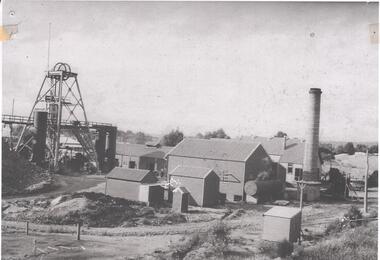
Photograph - NORTH DEBORAH GOLD MINE GOLDEN SQUARE
Black and white photograph of North Deborah Gold Mine, 1940's. View of entire site showing poppet head, trestleway, engine house, chimney stack. Two ore bins to the right of poppet head. 1920's vehicle on far right of photo. Country style outhgouse in foreground of photo. Chimney stack on RH side. -
 Bendigo Historical Society Inc.
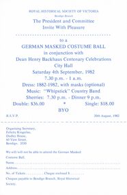
Document - DEAN HENRY BACKHAUS CENTENARY CELEBRATIONS, CITY HALL, 4 September 1982
a/ Royal Historical Society Of Victoria Bendigo Branch The President and Committee Invite With Pleasure to a Costume Ball in conjunction with Dean Henry Backhaus Centenary Celebrations, City Hall Saturday 4th September, 1982 7.30pm-1am. Dress: 1882-1982, with masks (optional) Music: 'Whipstick' Country Band Sherries: 7.30pm - Dinner 9pm. Double: $36.00 Single: $18.00 R.S.V.P 20 August, 1982. Organising Secretary, Felicity Kingerlee, Dudley House, 60 View Street, Bendigo 3550. We will/will not be able . . . . b/ Poster: Dean Henry Backhaus Centenary Celebrations German Masked Costume Ball 4th September, 1982 City Hall - Bendigo. Picture by Dorothy Carroll. The Mass Tent Used by Dean Backhaus on the Bendigo Goldfield. Royal Historical Society Of Victoria Bendigo Branch. c/ Royal Historical Society Of Victoria Bendigo Branch Dean Henry Backhaus Centenary Celebrations German Masked Costume Ball. Picture: Chair used by Dean Backhaus. Hewn from a tree stump. Programme. City Hall, Bendigo, Saturday 4th September,1982. Dance Programme.event, official, historical/educational, royal historical society of victoria bendigo branch dean henry backhaus centenary celebrations a/ the president and committee invite costume ball 4th september, 1982 7.30pm-1am. dress: 1882-1982, with masks music: 'whipstick' country band sherries: 7.30pm - dinner 9pm. double: $36.00 single: $18.00 r.s.v.p 20 august, 1982. organising secretary, felicity kingerlee, dudley house, 60 view street, bendigo 3550. we will/will not be able . . . . b/ poster: german masked costume ball 4th september, 1982 city hall - bendigo. picture by dorothy carroll. the mass tent used by dean backhaus on the bendigo goldfield. c/ german masked costume ball. picture: chair used by dean backhaus. hewn from a tree stump. programme. city hall, bendigo, saturday 4th september, 1982. dance programme. -
 Monbulk RSL Sub Branch
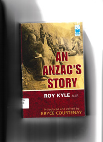
Book, Roy Kyle, An ANZAC's story, 2003
Roy Kyle started writing his remarkable memoirs at the age of eighty-nine and almost completed his story before he died. Bryce Courtney was asked if he would edit Roy's work with the view to it being published. Roy Kyle was a typical Anzac, fiercely patriotic and prepared to give his life for King and country. He couldn't wait to have a go and enlisted at seventeen, a year underage, and found himself in a trench in Lone Pine on his eighteenth birthday. The battle of Lone Pine, more than any other, established the legend of Gallipoli and was where a new nation was called upon to test its courage. One of the last to leave Gallipoli, Roy Kyle served in Egypt and later at the Somme where he was wounded in the head, arms and back.Bibliography, ill, p.300.non-fictionRoy Kyle started writing his remarkable memoirs at the age of eighty-nine and almost completed his story before he died. Bryce Courtney was asked if he would edit Roy's work with the view to it being published. Roy Kyle was a typical Anzac, fiercely patriotic and prepared to give his life for King and country. He couldn't wait to have a go and enlisted at seventeen, a year underage, and found himself in a trench in Lone Pine on his eighteenth birthday. The battle of Lone Pine, more than any other, established the legend of Gallipoli and was where a new nation was called upon to test its courage. One of the last to leave Gallipoli, Roy Kyle served in Egypt and later at the Somme where he was wounded in the head, arms and back.world war 1914-1918 - campaigns - gallipoli, gallipoli campaign - personal recollections -
 Stanley Athenaeum & Public Room
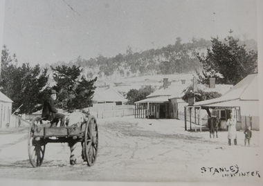
Photograph, Snow Scene Wallace Street Stanley
Street scene, view down Wallace Street towards the Star Hotel, shops and a man with a horse and cart with apron and a small boyStanley in Winter -
Dutch Australian Heritage Centre Victoria
tourists bicycle pennants, mid 20th century
TourismHow people went on holiday. A memento of simple holidays. The tradition of camping as the holiday of choice.calico, triangular pennant. One edged in blue, the other in red.4089.R1 - blue edged pennant, showing the tourist sites around a place called Epen in the southern part of the province of Limburg. This is known because the name of the town is in large red letters. Three locations shown 1. Kamper Boerderij - A farm providing camping grounds. 2. Kasteel Beusdael - The Beusdael Castle 3. Wingbergermoelen - Wingberger Mill Also a little tent beneath the name of the town, with refers to the camping holiday. Also a maker's mark on the pennant, a small triangle with the letters L, A & B within it. 4089.R2 - red edged pennant, showing the area around Vaals in Limburg province, the name is in large red letters. The scene shows the meeting point between the Netherlands, Germany & Belgium - "Drie Landen Punt" (Three Country Meeting Point) Also shows the height of the viewing point (193m), as well showing other features including: - Hotel Bellevue - Uitzichttoren - viewing tower - Panorama Aken - Panorama of Aachen, Germany - Spoorbrug-Moresnet - Railwaybridge-Moresnet in Belgium. Small makers mark. Black triangle, possible the same as that shown in the other pennant, though obscured. -
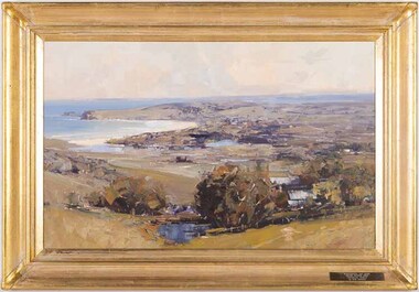
 Benalla Art Gallery
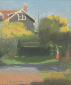
Painting, Clarice BECKETT, Spring morning, c. 1925
Born: Casterton, Victoria, Australia 1887; Died: 1935TonalismLedger Gift, 1988Urban landscape with view of partial house, trees and figures. Gold brushed wooden frame.Recto: Signed "C.Beckett" in red paint l.l.c of composition; Not dated; Not titledlandscape, house, figures, trees, australian art -
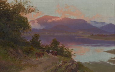 Benalla Art Gallery
Painting, W. C. PIGUENIT, Mt Wellington at sunrise: a view from Risdon Cove towards Glenorchy, c. 1870
Born: Hobart, Tasmania, Australia 1836; Died: Hunter's Hill, New South Wales, Australia 1914RomanticismLedger Gift, 1976Rural landscape with cows, track, lake and large mountains and clouds. Golden gesso painted timber frame.Recto: Signed "W. C. Piguenit" in black oil in l.l.c of composition; Not dated; Not titledpainting, landscape, water, animals, cows, boats, trees, mountains, clouds, sky, colonial, reflections -
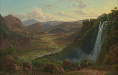 Benalla Art Gallery
Painting, Eugene VON GUERARD, The fall of the Veliono near Terni with the view up the Valley of the River Nera, 1885
Born: Vienna, Austria 1811; Arrived: Melbourne, Victoria, Australia 1852; Died: London, Middlesex England 1901RomanticismLedger Gift, 1984Rural valley and mountain landscape with two figures walking down a track beside a waterfall towards a river. Gold brushed gesso decorative edged timber frame.Recto: Signed and dated "Eug.V.Guérard / D. 85" in red oil in l.r.c of composition; Not titledpainting, landscape, river, cliff, mountain, figures, buildings, waterfall, sky, clouds -
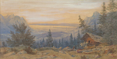 Benalla Art Gallery
Watercolour, Nicholas CHEVALIER, Swiss scene, 1886
Born: St Petersurg, Russia 1828; Arrived: Melbourne, Victoria, Australia 1854; Lived and worked: Switzerland 1845-1848, Germany 1851-1854, Australia 1854-1865, New Zealand 1865-1866, England 1870-1902; Died: London, Middlesex, England 1902RomanticismGift of Mrs E.E. Ledger, 1985View from rustic house with two figures overlooking lake surrounded by mountains and trees. Grey brushed stained timber.Recto: Signed and dated "N.Chevalier. / 1886" in brown watercolour in l.l.c of composition; Not titledwatercolour, landscape, waterscape, building, trees, mountains, water, cabin, sunset -
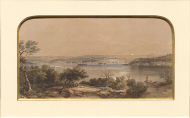 Benalla Art Gallery
Print, Conrad MARTENS, View of Sydney. NSW, 1855
Born: London, England 1801; Arrived: Sydney, New South Wales, Australia 1835; Died: Sydney, New South Wales, Australia 1878ColonialBennett Bequest, 1999 Hand-coloured lithograph depicting industrial waterscape with rocky shoreline and ships and buildings in background. Black painted timber frame with off white arched window mount and gold brushed internal window edgeRecto: Not signed, not dated, not titled print, waterscape, sea, harbour, land, figures, boats, tress, sydney harbour, buildings -
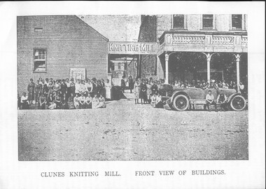 Clunes Museum
Photograph, CLUNES KNITTING MILL
The Clunes Knitting Mill in Fraser Street, Clunes was the former Salvation Army Barracks which were moved from Bailey Street, Clunes to Fraser Street, Clunes by tractor in 1918. The Country Townspeople's League was founded in Clunes its mission was to campaign to decentralise industry and provide manufacturing and employment opportunities in country Victoria, specifically at that time, for the continued financial support of the Clunes Knitting Mills located in Fraser Street, Clunes, Victoria. A Bill to give effect to the proposed Clunes Country Industries Policy was to be introduced at the assembly of the new Victorian Parliament in around 1921. Black and white photocopy of a group of people in front of the Clunes Knitting Mill in Fraser Street, Clunes.Printed on bottom of page: CLUNES KNITTING MILL - FRONT VIEW OF BUILDINGScuttle, rowe, clunes country industries policy -
 El Dorado Museum Association Inc.
Photograph - Digital Image
Image depicts an east view of El Dorado, circa 1920s.el dorado, eldorado -
 El Dorado Museum Association Inc.
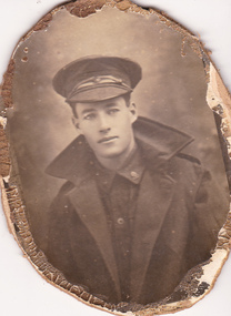
Photograph - Digital Image - 2nd Corporal Frederick A. McLaughlin, c1914 - 1918
McLaughlin, Frederick Arthur Service number: 10307 Australian Imperial Force Ranks held: Sapper, 2nd Corporal Service: Australian Imperial Force Unit: 10th Field Company, Australian Engineers Recommended for Military Medal, 13 September 1918 'Distinguished himself by gallantry and devotion to duty in bringing up material for a bridge urgently required East of Vaux. Lance Corporal McLaughlin was in charge of the wagons conveying material for this purpose and led the way over a road under heavy shell-fire in full view of the enemy. The determination and judgement shown by this N.C.O. in this, as in earlier operations, have shown him to be an excellent soldier'. first world war, world war one, wwi, australian imperial force, aif, el dorado, eldorado, soldiers, men -
 El Dorado Museum Association Inc.
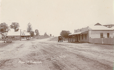
Photograph - Digital Image
... high-country Main Street view South Mackay Street, El Dorado ...Main Street view South Mackay Street, El Dorado.bottom left 'Main St. Eldorado' ; bottom middle 'Thelma Studio WANGARATTA'eldorado, mackay street eldorado, main street eldorado, star hotel, star hotel eldorado -
Tatura Irrigation & Wartime Camps Museum
Box, Tatura Souvenirs/Royal Visit 1954, Various
Collection of 1954 Royal Visit and Tatura Souvenirs memorbillia. Newspaper - Tatura Guardian - Souvenir of Royal Visit 1954|School Souvenir booklet - Royal Visit|School booklet - Royal Visit - Red cover|School booklet - Royal Visit - Black cover|State Reception Invitation and Booklet to Jack Lowry - Royal Visit|Note Pad - Spiral bound - Royal Family|Photo of Queen arriving at Tatura Railway Station and Entry Card to Station Reserve.|China Plate - Royal Tour.|2Plastic beakers - Royal Visit|1 British Flag|1 Souvenir Royal Flag|Souvenir Royal Flag - Red Cross|Stubby holder - Tatura Waterwheel Country| Glass bowl - Photo of Tatura|Broken - Original RC Church - Jug - C. 1900| China Jug - A View of Tatura| Water Bottle - Tatura Youth Club. C.2005|2 "Get Hooked on Tatura"|3 Tatura Post Cards - C. 1990|Magnet - "Stick with Tatura - 3SR radio|TaturaBeige coloured rectangle boxlocal history, royal visit souvenirs, tatura souvenirs, civic, memento, souvenirs -
Tatura Irrigation & Wartime Camps Museum
Book, The Rural Book, 1991
Written as information for rural areas with a view to informing them of availability of Government services. Foreword by Simon Crean, Minister for Primary Industry and Energy.Cream cover with etching showing rural activities guide to rural dwellers.country link program, books, reference, simon crean, government services, minister for primary industry and energy -
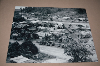 Wangaratta RSL Sub Branch
Photograph, c1945
... high-country View of HQ Australian Army Services Corps Issuing ...View of HQ Australian Army Services Corps Issuing Depot on Tarakan Island. The 2/24th Battalion was an infantry battalion of the Australian Army, which served during World War II .A unit of all-volunteers, it was formed in July 1940 from primarily Victorian volunteers and was known as "Wangaratta's Own" because of the time the battalion spent in the town during its formative period prior to deployment overseas. It served in North Africa in 1941–1942 as part of the 26th Brigade, which was assigned to the 7th Division, before being reassigned to the 9th Division. In early 1943, the battalion returned to Australia and later took part in campaigns against the Japanese in New Guinea in 1943–1944 and Borneo in 1945, before being disbanded in 1946. The 2/24th suffered the highest number of casualties of any 2nd AIF infantry battalion. The Unit was granted the Freedom of the City by the Rural City of Wangaratta in 1996 and one of the first, if not the first, to receive this type of honour. Reproduced black and white photograph of tent structures with supplies and vehicles in foreground. Handwritten on rear - Tarakan2/24th battalion, wangaratta, tarakan, ww2 -
 Hume City Civic Collection
Photograph, early 1990's
The 20 photographs were taken of a number of archaeological sites in Sunbury of sacred sites and aboriginal rings. The photographs were included in a study of these sites which was published by the Shire of Bulla in the early 1990's.A view of Aboriginal Ring Site near Rupertswood. The country is undulating with trees in the middle distance and the ring in the foreground.aboriginal ring sites, george evans collection -
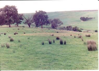
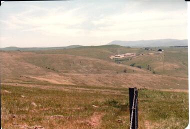 Hume City Civic Collection
Photograph, early 1980s
... . It is a panoramic view of open country NW of Sunbury near Riddell Road... with rounded corners. It is a panoramic view of open country NW ...The Sunbury Tip was transferred from the end of Reservoir Road as housing development spread in that area to a site on the NW side of Mt. Holden near Riddell Road in the early 1980s.A landscape coloured photograph with rounded corners. It is a panoramic view of open country NW of Sunbury near Riddell Road. There is a fence post with barbed wire hanging from it in the immediate foreground and Macedon Ranges and part of the Western Highlands can be seen across the skyline.macedon ranges, mt. macedon, camel's hump, sunbury municipal tip, george evans collection -
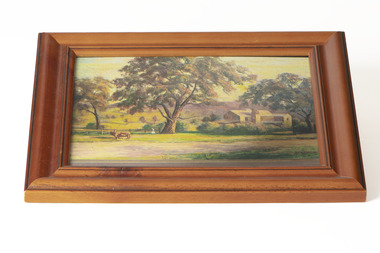 Chiltern Athenaeum Trust
Painting - Artwork, Fanny Bartley, Bartley's Brewery
Bartley's Brewery, Howlong Road, Chiltern (photograph of a painting by Fanny Bartley) Property owned by Benjaming Jackson Bartley 1834-1899Australian Impressionism, Naturalism, Colonial Art, Folk ArtA small, rectangular painting with a wood frame in a basic relief styleSignature in bottom right corner of paintingaustralian landscape, landscape, farm -
 Wangaratta Art Gallery
Painting, Ken Knight, Coastal Vista, c. 1992
Knight’s art style is heavily influenced by the Australian Impressionist movement of the late 19th century and he paints his work in outdoor settings, which is known as plein-air painting. Rural City of Wangaratta Collection, Wangaratta Art Prize Grand Winner 1992.An aerial landscape of a costal view painted in oil using a tonal colour palette of browns, blues, greens, oranges, and whites.Obverse: KEN KNIGHT/ (bottom right corner) WANGARATTA ART SHOW/ GRAND WINNER 1992/ 'COASTAL VISTA'/ By KEN KNIGHT/ (plaque mounted on frame)wangaratta art gallery, ken knight, landscape, painting, costal, plein-air, plein air -
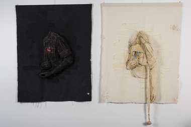 Nillumbik Shire Council
Mixed Media (textiles): Rosalie COGAN (b.1948 Vaght, Netherlands), Rosalie Cogan, War and Peace, 1987
Cogan is a textile artist and her work is political in nature. 'War and Peace' is about the Vietnam War and a statement about patriotism in war, of lessons not learnt, of remembrance and never forgetting. This work is an expression of her feelings towards this time and of her husband's experience who fought in this war. The Republic of Vietnam 'Vietnam Campaign Medal' is from the former country of South Vietnam (Republic of Vietnam). Established in 1966, it was awarded to members of United States, Australian, and New Zealand military forces serving six months or more in support of Republic of Vietnam military operations. The medal is issued with a device known as the 1960 Bar. The bar displays the date of 1960 followed by a dash and a blank space. The unusual appearance was caused by the government of the Republic of Vietnam stating that the 1960 bar would show the dates of the Vietnam War from start to finish, with the ending date placed on the 1960 bar after the South Vietnamese had triumphed over North Vietnam (the Democratic Republic of Vietnam). Since South Vietnam fell, and the government ceased to exist, an ending date for the 1960 Bar was never established. The Vietnam Campaign Medal is considered a foreign award by the U.S., Australian, and New Zealand governments. The joint Australian and New Zealand campaign medal awarded for service in the Vietnam War is the 'Vietnam Medal'. The obverse of this medal shows the crowned head of Queen Elizabeth II, with titles, while the reverse has the inscription VIETNAM above a symbolic representation of the ideological war in Vietnam. The RSL poppy (the Flanders poppy) has long been a part of Remembrance Day, the ritual that marks the Armistice of 11 November 1918, and is also increasingly being used as part of Anzac Day observances. During the First World War, red poppies were among the first plants to spring up in the devastated battlefields of northern France and Belgium. In soldiers' folklore, the vivid red of the poppy came from the blood of their comrades soaking the ground. The poppy soon became widely accepted throughout the allied nations as the flower of remembrance to be worn on Armistice Day. Today the RSL continues to sell poppies for Remembrance Day to raise funds for its welfare work. "War and Peace' is significant as it explores and highlights a period in history (the Vietnam War), which was contentious both socially and politically. Cogan and her family lived locally, in the Shire of Eltham during this time, and her work is a reflection of the experiences and sentiments of a section of the Nillumbik community. Textile piece. 'War": Cast muslin, machine embroidery onto white calico. Tanin dye, poly thread, side bust view (hand, shoulder and arm). Black machine stiching on shirt and shirt pocket with two vietnam medals. A replica of the 'Vietnam Medal' in muslin is shown reverse and has the inscription VIETNAM above a symbolic representation of the ideological war in Vietnam, which is of a male figure standing between two spherical shapes. The ribbon has a vertical central section of bright yellow which has centrally superimposed on it three thin stripes of red, (representing the South Vietnamese flag) flanked by two stripes of red (representing the Army). On the left is a dark blue stripe representing the Navy and on the right, a light blue stripe representing the Air Force. A replica in muslin of the second medal is the Republic of Vietnam 'Vietnam Campaign Medal' of the former country of South Vietnam. The ribbon has green and white strips with a device bearing the inscription ‘1960 – ‘. The medal is traditionally a gold and white enamelled star with a green, red and gold centre motif. Right hand is touching the medals/heart, while left arm is left resting to the left side over a crutch which ends in a rolled up bandage. 'Peace': Cast muslin, machine embroidery onto calico. Black dye, poly thread and RSL poppy. Side bust view (hand, shoulder and arm). Yellow machine stiching on black shirt and shirt pocket with RSL red poppy on shirt pocket. Right hand is reaching to touch the poppy, while left arm is slightly bent resting on its' left side. Nonetextile, muslin, embroidery, vietnam war, medals, vietnam medal, vietnam campaign medal, rsl poppy, war, peace, armistice, remembrance day, anzac -
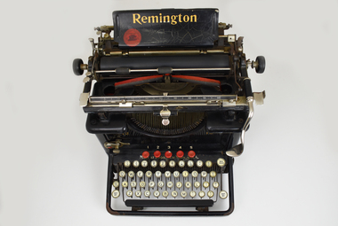 National Wool Museum
Functional object - Typewriter, Remington Typewriter Company, c.1925
This Remington No.12 typewriter is of the typebar, front-strike class. It was made by the Remington Typewriter Company of Ilion, New York, U.S.A. in about 1925. The Model No. 12 was introduced in 1922 and was one of the first 'visible writer' machines, in which the typed characters were visible to the operator. Previous models were of the upstrike class in which the characters were typed on the underside of the platen. To see what had been typed the operator had to raise the platen, meaning the typist was typing blind much of the time. This machine was used by Margaret Ganly née Burn in the 1930s. It was purchased for her by one of the sons of William Pride, a famous saddle maker in Geelong, William was Margaret’s grandfather. The typewriter was donated with original sales receipt and servicing tools. Margaret worked at Dennys for 7 years during the 1930s. The typewriter is accompanied with a story written by Margaret about her time working at the company. Margret married Jack Ganly, a fellow employee of Dennys. The Ganly name was well known within Dennys, with three generations of the Ganly family working at the company. WORKING CONDITIONS & OFFICE WORK DUTIES. Written by Margaret Burn in 2021. Worked at Dennys Lascelles in the 1930s. In the 1930s coming out of the Depression, jobs were hard to come by and had to be clung to by efficiency and subserviency. There was no union to protect workers – bosses could be tough and rough. Dennys Lascelles revolved around fortnightly wool sales in the “season” – September to May. Sale day was always a day of suppressed excitement. Preparation from a clerical point of view was complete and we now awaited the aftermath of the actual wool auction. The building teemed with people. There were country people down to see their wool sold, buyers of many nationalities, or from the big cities, who were coming in and out of the building all day. Their role was to inspect the acres of wool bales displayed on the show floors; however, caterers were present to feed clients, and there was plenty of social interactions on top of business. The office staff did not go home but waited until the first figures came back from the wool sales and the machines went in to action, both human and mechanical, preparing the invoices for the buyers’ firms. This comprised of lists of lot numbers, weights, prices per lb., and the total prices paid. A lot of this was done by old-school typewriters, making this work a big, heavy, tiring job. Before the finished lists could be dispatched, they were collated on an “abstract”. The lists had to balance with the catalogue from which the invoices had been prepared. This never happened automatically. All the paperwork had to be split up amongst pairs of workers and checked until discrepancies were found. This would happen until midnight but occasionally went until 2 or 3 am. Once complete, the invoices could then be rushed off to the buyers’ firms usually in Melbourne, and hire cars took the staff home. It was back on the job the next morning, usually around 8.30. The office hours varied according to the size of the sale and work involved. Some days started as early as 8 and could finish around 5.30. The second phase of work began with the account sales to be prepared for the sellers of the wool. These detailed all the weights, descriptions of wool, brands, and prices. One Sales account could have multitudes of lot numbers, all needing to be individually described. Various charges needed to be deducted such as finance for woolpacks, extra stock, or farmers who were given a loan to live on during the season. Details of how payment was to be made was also noted, whether the seller was to be paid by cheque, to a bank, or credited to their account with the company (which often left the seller still in debt). For a couple of months in the winter, things were quieter when staff took holidays and were sometimes given afternoons off. But there were still weekly skin sales and stock sales around the state. The annual end of June figures to be prepared for a big company like Dennys with branches all around the state also kept the staff busy. In good years there was sometimes a bonus. On sale days there was a bar open for the clients and wool buyers. This added to the excitement for the young girls, who were strictly barred from using it, but somehow managed to sneak a gin and tonic. This is how I had my first ever, before the evening meal. There was also the romantic notion in some minds, with all the influx of males, that some of us might end up on a wealthy station, or be noticed by an exotic buyer. To my knowledge, this never happened at Dennys Lascelles Limited. Group staff photo at Dennys Lascelles Limited. Margaret Burn. Age 18 or 19. Jack Ganly (Margaret’s future husband). 22.The typewriter has a black painted metal frame. The top section of the typewriter consists of a cylindrical platen on a carriage featuring plated metal fittings. A curved folding paper guide sits behind the platen and moves on the horizontal axis when the user types on the keyboard. A horizontal semicircular type basket with typebar links the top section to the lower keyboard. The ink ribbon is carried between two spools on a horizontal axis, one on each side of the type-basket. At the rear, a paper tray features gold lettering which reads ‘Remington’. At the front, a four-row QWERTY keyboard is found with 42-character keys total. 'SHIFT LOCK' and 'SHIFT KEY' are to the left of the keyboard, 'BACK SPACER' and 'SHIFT KEY' to the right. All keys are circular, white with black lettering. At the top of the keyboard are five circular red keys with the numbers 1-5 displayed behind their respective keys. A Spacebar is found along the front of the keyboard. The typewriter is accompanied by a cardboard box. This box contains the original sales receipt, on blue paper with grey lead handwriting. It also contains spare parts, a spare ribbon stretched between two spools, and cleaning tools such as brushes of differing sizes. Serial Number. Engraved. "LX45395" Gold lettering. Paper tray. “Remington” Gold Lettering. Behind keyboard. “Made in Ilion, New York, U.S.A. Gold Lettering. Mirrored both sides of type-basket. “12”remington, dennys lascelles ltd, worker conditions 1930s -
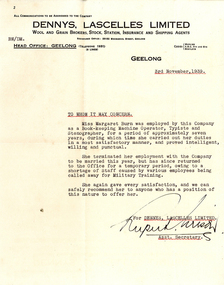 National Wool Museum
Letter - Letter of reference for Margaret Burn, 03/11/1939
Letter of Reference for Miss Margaret Burn detailing her work as a bookkeeper, machine operator, typist, and stenographer over seven years at Dennys Lascelles Limited. The letter details her leaving the company as she married in 1939. In the same year, Ms Burn returned to the office owing to the shortage of staff caused by various employees being called away for Military Training. Included in the staff called away for military training was her newlywed husband, Mr Jack Ganly. A fellow employee of Dennys, the Ganly name was well known within the company, with three generations of the Ganly family working at Dennys. Margaret worked at Dennys for 7 years during the 1930s. The Letter of Reference is accompanied with a story written by Margaret about her time working at the company. WORKING CONDITIONS & OFFICE WORK DUTIES. Written by Margaret Burn in 2021. Worked at Dennys Lascelles in the 1930s. In the 1930s coming out of the Depression, jobs were hard to come by and had to be clung to by efficiency and subserviency. There was no union to protect workers – bosses could be tough and rough. Dennys Lascelles revolved around fortnightly wool sales in the “season” – September to May. Sale day was always a day of suppressed excitement. Preparation from a clerical point of view was complete and we now awaited the aftermath of the actual wool auction. The building teemed with people. There were country people down to see their wool sold, buyers of many nationalities, or from the big cities, who were coming in and out of the building all day. Their role was to inspect the acres of wool bales displayed on the show floors; however, caterers were present to feed clients, and there was plenty of social interactions on top of business. The office staff did not go home but waited until the first figures came back from the wool sales and the machines went in to action, both human and mechanical, preparing the invoices for the buyers’ firms. This comprised of lists of lot numbers, weights, prices per lb., and the total prices paid. A lot of this was done by old-school typewriters, making this work a big, heavy, tiring job. Before the finished lists could be dispatched, they were collated on an “abstract”. The lists had to balance with the catalogue from which the invoices had been prepared. This never happened automatically. All the paperwork had to be split up amongst pairs of workers and checked until discrepancies were found. This would happen until midnight but occasionally went until 2 or 3 am. Once complete, the invoices could then be rushed off to the buyers’ firms usually in Melbourne, and hire cars took the staff home. It was back on the job the next morning, usually around 8.30. The office hours varied according to the size of the sale and work involved. Some days started as early as 8 and could finish around 5.30. The second phase of work began with the account sales to be prepared for the sellers of the wool. These detailed all the weights, descriptions of wool, brands, and prices. One Sales account could have multitudes of lot numbers, all needing to be individually described. Various charges needed to be deducted such as finance for woolpacks, extra stock, or farmers who were given a loan to live on during the season. Details of how payment was to be made was also noted, whether the seller was to be paid by cheque, to a bank, or credited to their account with the company (which often left the seller still in debt). For a couple of months in the winter, things were quieter when staff took holidays and were sometimes given afternoons off. But there were still weekly skin sales and stock sales around the state. The annual end of June figures to be prepared for a big company like Dennys with branches all around the state also kept the staff busy. In good years there was sometimes a bonus. On sale days there was a bar open for the clients and wool buyers. This added to the excitement for the young girls, who were strictly barred from using it, but somehow managed to sneak a gin and tonic. This is how I had my first ever, before the evening meal. There was also the romantic notion in some minds, with all the influx of males, that some of us might end up on a wealthy station, or be noticed by an exotic buyer. To my knowledge, this never happened at Dennys Lascelles Limited. Group staff photo at Dennys Lascelles Limited. Margaret Burn. Age 18 or 19. Jack Ganly (Margaret’s future husband). 22. Sheet of paper shorter in length than A4 size, creamed with age. Paper has a header for Dennys, Lascelles Limited’s Head Office at 32 Moorabool Street, Geelong. Body of paper is made up of 3 paragraphs in a typewritten message of black ink with subheadings highlighted with a red underline. The text is finished with a signature at the bottom of the paper. Paper is accompanied by its original envelope. Envelope has typewritten text in black ink with a red underline located at the centre. It also has return to sender instructions to Dennys, Lascelles Limited in the lower left-hand corner.Typewritten text, black and red ink. Multiple. See multimediadennys lascelles ltd, worker conditions 1930s, letter of reference -
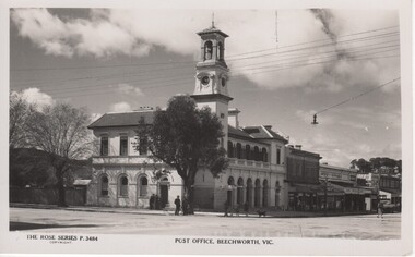 Rutherglen Historical Society
Postcard - Image, Rose Stereographic Co, 1910-1964 (Approximate)
Photographic postcard showing view of Beechworth Post Officebeechworth, post office -
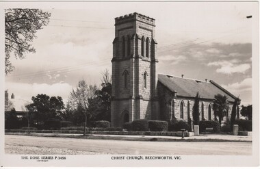 Rutherglen Historical Society
Postcard - Image, Rose Stereographic Co, c 1915
Photographic postcard showing view of Christ Church, Beechworthbeechworth, christ church beechworth, church