Showing 375 items
matching early land settlers
-
 Greensborough Historical Society
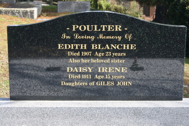
Photograph - Digital Image, Grave of Edith Poulter, Greensborough Cemetery, 1907_
Grave of Edith Poulter (died 1907) in Plot# G1/G2 Greensborough Cemetery. Post 2012 descendants of some pioneer families have been replacing damaged headstones.Greensborough Cemetery was created when land was given for the cemetery by Mr William Poulter, a local settler, about 1864. The cemetery holds the graves of many early settlers in the district. Digital copy of colour photograph of grave/headstone.edith poulter, greensborough cemetery -
 Greensborough Historical Society
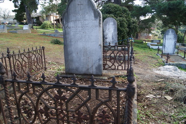
Photograph - Digital Image, Grave of Joseph Frost Poulter, Greensborough Cemetery, 18/11/1880
Grave of Joseph Frost Poulter (died 18/11/1880) in Plot# B12/13 Greensborough Cemetery. Greensborough Cemetery was created when land was given for the cemetery by Mr William Poulter, a local settler, about 1864. The cemetery holds the graves of many early settlers in the district. Digital copy of colour photograph of grave/headstone.joseph frost poulter, greensborough cemetery -
 Greensborough Historical Society
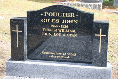
Photograph - Digital image, Grave of Giles Poulter, Greensborough Cemetery, 15/12/1926
Grave of Giles John Poulter (died 15/12/1926) in Plot# G3 Greensborough Cemetery (new headstone). Post 2012 descendants of some pioneer families have been replacing damaged headstones.Greensborough Cemetery was created when land was given for the cemetery by Mr William Poulter, a local settler, about 1864. The cemetery holds the graves of many early settlers in the district. Digital copy of colour photograph of grave/headstone.giles john poulter, greensborough cemetery -
![Photograph - Digital Image, Grave of William Poulter and Mary Chapman Poulter, Greensborough Cemetery [damaged headstone], 13/03/1888](/media/collectors/4f729f5697f83e03086015b8/items/54c5d7782162f117305391b6/item-media/54c5d7b92162f11730539655/item-fit-380x285.jpg) Greensborough Historical Society
Greensborough Historical SocietyPhotograph - Digital Image, Grave of William Poulter and Mary Chapman Poulter, Greensborough Cemetery [damaged headstone], 13/03/1888
Grave of William Poulter (died 13/03/1888) and Mary Poulter (died 18/09/1899) in Plot#B8 Greensborough Cemetery. This damaged monument was restored to its former position.Greensborough Cemetery was created when land was given for the cemetery by Mr William Poulter, a local settler, about 1864. The cemetery holds the graves of many early settlers in the district. Digital copy of colour photograph of grave/headstone.william poulter, mary poulter, greensborough cemetery -
 Greensborough Historical Society
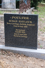
Photograph - Digital image, Grave of Susan Haylock Poulter, Greensborough Cemetery, 20/07/1886
Grave of Susan Haylock Poulter (died 20/07/1886) in Plot# unknown Greensborough Cemetery. Post 2012 descendants of some pioneer families have been replacing damaged headstones.Greensborough Cemetery was created when land was given for the cemetery by Mr William Poulter, a local settler, about 1864. The cemetery holds the graves of many early settlers in the district. Digital copy of colour photograph of grave/headstone.susan haylock, susan poulter, greensborough cemetery -
 Greensborough Historical Society
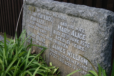
Photograph - Digital Image, Grave of William Haylock Poulter and Mary Alice Poulter, and their children Ruby O. Poulter and James W. Poulter, Greensborough Cemetery, 20/03/1934
Grave of William Haylock Poulter (died 20/03/1934), Mary Alice Poulter (died 28/6/1936), Ruby Olive Poulter (died 31/5/1917) and James William Poulter (killed in action France 4/10/1918) in Plot# A5/A6 Greensborough Cemetery.Greensborough Cemetery was created when land was given for the cemetery by Mr William Poulter, a local settler, about 1864. The cemetery holds the graves of many early settlers in the district. Digital copy of colour photograph of grave/headstone.william haylock poulter, mary alice poulter, ruby poulter, james poulter, greensborough cemetery -
 Greensborough Historical Society
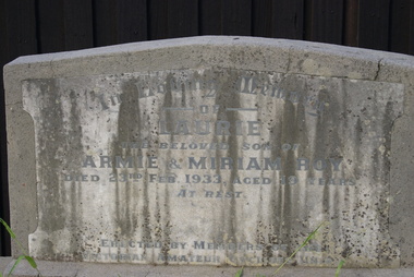
Photograph - Digital Image, Grave of Laurie Roy, Greensborough Cemetery, 23/02/1933
Grave of Laurie Roy (died 23/02/1933) in Plot# F3 Greensborough Cemetery. Headstone erected by members of the Victorian Amateur Cyclists Union. Greensborough Cemetery was created when land was given for the cemetery by Mr William Poulter, a local settler, about 1864. The cemetery holds the graves of many early settlers in the district. Digital copy of colour photograph of grave/headstone.laurie roy, victorian amateur cyclists union, greensborough cemetery -
![Photograph - Digital Image, Grave of John Scotland, Mary Colquhoun, Catherine Sievwright and Jessie Scotland, Greensborough Cemetery [damaged], 21/11/1888](/media/collectors/4f729f5697f83e03086015b8/items/54c5dc362162f1173053ff3d/item-media/54c5dc752162f1173054050b/item-fit-380x285.jpg) Greensborough Historical Society
Greensborough Historical SocietyPhotograph - Digital Image, Grave of John Scotland, Mary Colquhoun, Catherine Sievwright and Jessie Scotland, Greensborough Cemetery [damaged], 21/11/1888
Grave of John Scotland (died 21/11/1888), Mary Colquhoun (died 15/02/1902), Catherine Sievwright (died 10/01/1910) and Jessie Scotland (died 21/07/1924) in Plot# M8/M9 Greensborough Cemetery. Photograph shows this monument after vandals toppled it. Greensborough Cemetery was created when land was given for the cemetery by Mr William Poulter, a local settler, about 1864. The cemetery holds the graves of many early settlers in the district. Digital copy of colour photograph of grave/headstone [damaged]john scotland, mary colquhoun, catherine sievwright, janet scotland, greensborough cemetery -
 Greensborough Historical Society
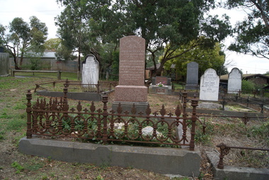
Photograph - Digital Image, Restored grave of John Scotland, Mary Colquhoun, Catherine Sievwright and Jessie Scotland, Greensborough Cemetery, 21/11/1888
Grave of John Scotland (died 21/11/1888), Mary Colquhoun(died 15/02/1902), Catherine Sievwright (died 10/01/1910) and Janet Scotland (died 21/07/1924) in Plot# M8/M9 Greensborough Cemetery. Headstone has been restored.Greensborough Cemetery was created when land was given for the cemetery by Mr William Poulter, a local settler, about 1864. The cemetery holds the graves of many early settlers in the district. Digital copy of colour photograph of grave/headstone.john scotland, mary colquhoun, catherine sievwright, janet scotland, greensborough cemetery -
 Greensborough Historical Society
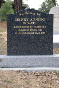
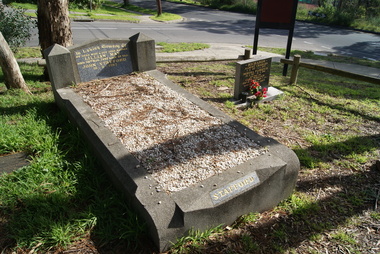
Photograph - Digital Image, Grave of Henry Anning Splatt at Greensborough Cemetery, 17/11/1886
Grave of Henry Anning Splatt (died 17/11/1886) in Plot#G9 Greensborough Cemetery. Post 2012 descendants of some pioneer families have been replacing damaged headstones.Greensborough Cemetery was created when land was given for the cemetery by Mr William Poulter, a local settler, about 1864. The cemetery holds the graves of many early settlers in the district. Digital copy of colour photograph of grave/headstone.henry anning splatt, greensborough cemetery -
 Greensborough Historical Society
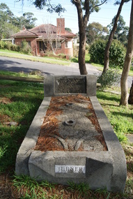
Photograph - Digital Image, Grave of Lillian M. Stafford, Greensborough Cemetery, 29/11/1943
Grave of Lillian M. Stafford (died 29/11/1943) in Plot#R3 Greensborough Cemetery. Greensborough Cemetery was created when land was given for the cemetery by Mr William Poulter, a local settler, about 1864. The cemetery holds the graves of many early settlers in the district. Digital copy of colour photograph of grave/headstone.lillian stafford, greensborough cemetery -
 Greensborough Historical Society
Photograph - Digital Image, Grave of Charlotte Turner and George Turner, Greensborough Cemetery, 25/08/1944
Grave of Charlotte Turner (died 25/08/1944) and George Turner (05/07/1951) in Plot# R5 Greensborough Cemetery. Greensborough Cemetery was created when land was given for the cemetery by Mr William Poulter, a local settler, about 1864. The cemetery holds the graves of many early settlers in the district. Digital copy of colour photograph of grave/headstone.charlotte turner, george turner, greensborough cemetery -
 Greensborough Historical Society
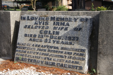
Photograph - Digital Image, Grave of Avis I. Williams , Greensborough Cemetery, 18/12/1937
Grave of Avis I. Williams (died 18/12/1937) in Plot# I7 Greensborough Cemetery. Greensborough Cemetery was created when land was given for the cemetery by Mr William Poulter, a local settler, about 1864. The cemetery holds the graves of many early settlers in the district. Digital copy of colour photograph of grave/headstone.avis williams, greensborough cemetery -
![Photograph - Digital image, Greensborough Cemetery [view 1], 18/06/2013](/media/collectors/4f729f5697f83e03086015b8/items/54c5f72c2162f1173055bbb2/item-media/54c5f7722162f1173055c101/item-fit-380x285.jpg) Greensborough Historical Society
Greensborough Historical SocietyPhotograph - Digital image, Greensborough Cemetery [view 1], 18/06/2013
View of Greensborough Cemetery, June 18th 2013. Photography by Marilyn Smith.Greensborough Cemetery was created when land was given for the cemetery by Mr William Poulter, a local settler, about 1864. The cemetery holds the graves of many early settlers in the district. Digital copy of colour photograph of Greensborough Cemeterygreensborough cemetery -
![Photograph - Digital Image, Greensborough Cemetery [view 2] 2013, 18/06/2013](/media/collectors/4f729f5697f83e03086015b8/items/54c5f8802162f1173055d3d6/item-media/54c5f8ba2162f1173055d66a/item-fit-380x285.jpg) Greensborough Historical Society
Greensborough Historical SocietyPhotograph - Digital Image, Greensborough Cemetery [view 2] 2013, 18/06/2013
View of Greensborough Cemetery, June 18th 2013. Photography by Marilyn Smith.Greensborough Cemetery was created when land was given for the cemetery by Mr William Poulter, a local settler, about 1864. The cemetery holds the graves of many early settlers in the district. Digital copy of colour photograph of Greensborough Cemeterygreensborough cemetery -
 Greensborough Historical Society
Article, Printer Unknown, Greensborough, 1840o
Details the history of the current Greensborough township. It also mentions the early settlement of Kangaroo Point.Mentions early settlers such as William Poulter, James Chapman, James Mann and Edwin Willis Magger (Maygar).2 page printed document outlining the activities and motives of Edward Bernard Green, an early owner of the area of land that became Greensborough.Pencilled words on front page. greensborough, kangaroo point, edward green, poulter, mann, chapman, magger, mayger, melbourne to sydney mail contract -
![Photograph - Digital Image, Greensborough Cemetery [view 1] 2014, 28/05/2014](/media/collectors/4f729f5697f83e03086015b8/items/581060aed0cdd12660a1c09d/item-media/581060f6d0cdd12660a1ece7/item-fit-380x285.jpg) Greensborough Historical Society
Greensborough Historical SocietyPhotograph - Digital Image, Greensborough Cemetery [view 1] 2014, 28/05/2014
View of Greensborough Cemetery, 28th May 2014. Photography by Marilyn Smith.Greensborough Cemetery was created when land was given for the cemetery by Mr William Poulter, a local settler, about 1864. The cemetery holds the graves of many early settlers in the district. Digital copy of colour photograph of Greensborough Cemetery -
 Greensborough Historical Society
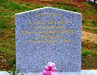
Photograph - Digital image, Grave of Alice Splatt, Greensborough Cemetery, 15/05/1898
Grave of Alice Splatt nee Memmott (died 1898) in Plot# G10 Greensborough Cemetery. This headstone has been repaired/restored by descendants of the family.Greensborough Cemetery was created when land was given for the cemetery by Mr William Poulter, a local settler, about 1864. The cemetery holds the graves of many early settlers in the district. Digital copy of colour photograph of grave/headstone.splatt family, alice splatt -
 Greensborough Historical Society
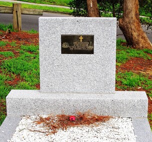
Photograph - Digital Image, Grave of John Huxley Carse, Greensborough Cemetery, 02/10/1926
Grave of John Huxley Carse (died 04/10/1926) in Plot#J15 Greensborough Cemetery. The grave was renovated in 2014.Greensborough Cemetery was created when land was given for the cemetery by Mr William Poulter, a local settler, about 1864. The cemetery holds the graves of many early settlers in the district. Digital copy of colour photograph of grave/headstone.john huxley carse, greensborough cemetery -
 Greensborough Historical Society
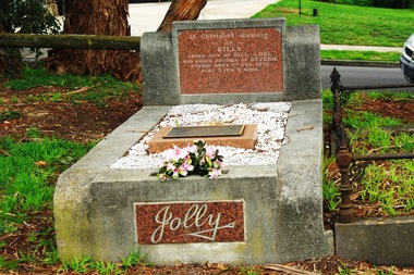
Photograph - Digital image, Marilyn Smith, William James (Billy) Jolly, William J Jolly and Adele Jolly, Greensborough Cemetery, 01/02/1945
Grave of William James (Billy) Jolly (died 1/2/1945), William J Jolly (died 10/05/1997) and Adele Jolly (died 21/2/2009) in Plot# O8 Greensborough CemeteryGreensborough Cemetery was created when land was given for the cemetery by Mr William Poulter, a local settler, about 1864. The cemetery holds the graves of many early settlers in the district. Digital copy of colour photograph of grave/headstone.william james jolly, billy jolly, adele jolly, greensborough cemetery -
 Greensborough Historical Society
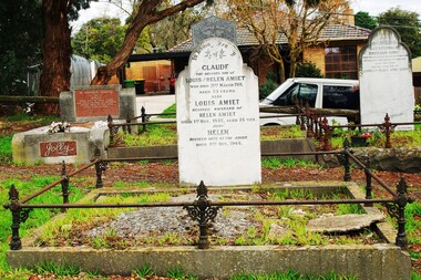
Photograph - Digital image, Marilyn Smith, Amiet family grave, Greensborough Cemetery, 21/03/1911
Grave of Claude Amiet (died 21/03/1911), Louis Amiet (died 1932) and Helen Amiet (died 1944) in Greensborough CemeteryGreensborough Cemetery was created when land was given for the cemetery by Mr William Poulter, a local settler, about 1864. The cemetery holds the graves of many early settlers in the district. Digital copy of colour photograph of grave/headstone.greensborough cemetery, claude amiet, louis amiet, helen amiet -
 Greensborough Historical Society
Article, The Willis Diary by Anne Paul. Based on A Pioneer Squatter's Life, 09/04/1837o
The Willis Diary by GHS member Anne Paul is based on A Pioneer Squatter's Life (Item158). The Willis family were early settlers at Lower Plenty, just near where the hotel and old bridge are today. Anne has reviewed and analysed this chapter from Historical Records of Victoria, Vol. 6. The Crown, the land, and the squatter, 1835-1840. She includes further information on the Willis family and photographs of the archaeological dig at the Bridge Inn Hotel Mernda in 2017.Diary of James L Willis from 1837, portraying hardships suffered in the young colony of Victoria.15 page, text and colour illustrations. Digital copy.willis family, plenty river, lower plenty, james willis, bridge inn hotel mernda -
Greensborough Historical Society
Article, A Squatter's life on the Plenty River at 'Wanstead' by Anne Paul, 09/04/1837o
The Willis Diary by GHS member Anne Paul is based on A Pioneer Squatter's Life (Item158). The Willis family were early settlers at Lower Plenty, just near where the hotel and old bridge are today. Anne has reviewed and analysed this chapter from Historical Records of Victoria, Vol. 6. The Crown, the land, and the squatter, 1835-1840. She includes further information on the Willis family and photographs of the archaeological dig at the Bridge Inn Hotel Mernda in 2017.Diary of James L Willis from 1837, portraying hardships suffered in the young colony of Victoria.10 pages, text and colour illustrations. Abridged hard copy of item 4491.willis family, plenty river, lower plenty, james willis, bridge inn hotel mernda -
 City of Moorabbin Historical Society (Operating the Box Cottage Museum)
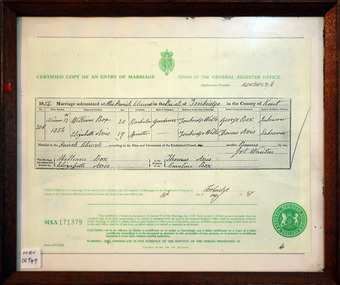
Document - Copy of Marriage Certificate William Box 1854, 14 May 1997
This copy of the Marriage Certificate of William and Elizabeth Avis-Box was obtained by CMHS member Dennis Maynard in May 1997. William Box and Elizabeth Avis Box came to Australia with his parents George and Mary Cripps-Box and siblings in 1856 William Box with his wife Elizabeth Avis Box and 13 children lived and farmed on the block of land in Jasper Road, East Brighton ( now McKinnon / Ormond) that was part of the Henry Dendy Special Survey 1841. Caroline Box, the eldest daughter of George and Mary Cripps-Box, remained in England working as a cook until she joined the family in Australia in 1863. William Box with his wife Elizabeth Avis Box and 13 children lived and farmed on the block of land in Jasper Road, East Brighton ( now McKinnon / Ormond) that was part of the Henry Dendy Special Survey 1841 Box Cottage Museum is the reconstructed pioneer cottage that William and Elizabeth lived in 1865 until they built a new house on the land. The Certified Copy of the Marriage Entry of William Box and Elizabeth Avis at the Parish Church, Tonbridge, Kent, England on November 13th 1854 in a wood frame with glass* CERTIFIED COPY OF AN ENTRY OF MARRIAGE / crest / GIVEN AT THE GENERAL REGISTER OFFICE / Application number C009059/0 / 1854 Marriage solemnised at The Parish Church of Tonbridge in the County of Kent / 206 / November 13th / 1854 / William Box 20 Bachelor Gardener / Elizabeth Avis 19 Spinster/ ………… Signed by William Box , Elizabeth Avis with Thomas Avis and Caroline Box as the Witnesses. Issued at Tonbridge 14th May 1997 MXA 171379 box william, box elizabeth avis, moorabbin, ormond, parish of tonbridge, farmers, dairy, market gardeners, pioneers, early settlers, kent, england, certificates, box caroline, avis thomas, -
 City of Moorabbin Historical Society (Operating the Box Cottage Museum)
Document - Genealogy Chart Henry Dendy (Photocopy), 19 thC
In 1840 Henry Dendy, a farmer in Surrey, England acquired a "Special Survey" from the Commissioners for Land and Emigration which gave Dendy the right to choose land in Port Phillip for the "bargain basement" price of only £1 per acre for 5120 acres, (an area of 8 square miles). The Special Survey also included the right to "the shipment of a worker for every £20 spent on land, whose free passage was paid by the Crown, equalling a total of 100 workers ". Accordingly Dendy sold his English holdings and paid the required £5120 and arrived in Melbourne in February 1841. However by this time land in the new colony was selling for £5 - £40 per acre. Because Henry Dendy possessed the order from the Colonial Office in London he was able to successfully oppose Super-intendant LaTrobe's attempts to alter the price of the land. Dendy appointed Jonathan Were, (an entrepreneur, who had arrived in 1839), as his Manager and who later became a partner. Together, Dendy and Were decided on an area 5 miles south from Melbourne, bounded by North Road, East Boundary Road, South Road and to the west by Port Phillip Bay. Were and Dendy pitched their tents in the area now known as ' Park St, Brighton' and sank a well near the corner of 'St Andrew's St and Wells St'. By 1845 J.B Were and Company had bought almost half of Dendy's land and Were built himself "Moorabbin House" in Were St Brighton made from stone, quarried from local cliffs. It was still standing in 1924. Legend records Moorabbin is named after the Aboriginal word for ' Mother's Milk ' The soil is very fertile and well supplied with water especially in the area called 'East Brighton' - now known as Bentleigh and East Bentleigh - By 1850 the area had developed with numerous market gardens, dairy farms, fruit gardens and vineyards supplying food for the growing population of Melbourne.In 1840 Henry Dendy, a farmer in Surrey, England acquired a "Special Survey" from the Commissioners for Land and Emigration which gave Dendy the right to choose land in Port Phillip for the price of only £1 per acre for 5120 acres. This land was called Brighton in the Parish of Moorabbin, County of Bourke and emigrants developed the land establishing market gardens , dairy and poultry farms that provided the food for the growing population of Melbourne. A photocopy of the Genealogy Chart of the Dendy Family that Henry Dendy brought with him when he emigrated to Melbourne 1841Genealogy signs and descriptionsdendy henry, dendy's special survey brighton 1841, governor gipps, captain lonsdale, super-intendant latrobe, port phillip, melbourne, new south wales, squatters, emmigrants, county of bourke, parish of moorabbin, early settlers, pioneers, market gardeners, dairy farmers, fruit farms, moorabbin, bentleigh, brighton, cheltenham, were jonathan binn, -
 City of Moorabbin Historical Society (Operating the Box Cottage Museum)
Document - Pedigree of Henry Dendy, c1840 Original ; Copy 1985
This is a copy of the document brought by Henry Dendy to the Colony in 1841. In 1840 Henry Dendy, a farmer in Surrey, England acquired a "Special Survey" from the Commissioners for Land and Emigration which gave Dendy the right to choose land in Port Phillip for the "bargain basement" price of only £1 per acre for 5120 acres, (an area of 8 square miles). The Special Survey also included the right to "the shipment of a worker for every £20 spent on land, whose free passage was paid by the Crown, equalling a total of 100 workers ". Accordingly Dendy sold his English holdings and paid the required £5120 and arrived in Melbourne in February 1841. However by this time land in the new colony was selling for £5 - £40 per acre. Because Henry Dendy possessed the order from the Colonial Office in London he was able to successfully oppose Super-intendant LaTrobe's attempts to alter the price of the land. Dendy appointed Jonathan Were, (an entrepreneur, who had arrived in 1839), as his Manager and who later became a partner. Together, Dendy and Were decided on an area 5 miles south from Melbourne, bounded by North Road, East Boundary Road, South Road and to the west by Port Phillip Bay. Were and Dendy pitched their tents in the area now known as ' Park St, Brighton' and sank a well near the corner of 'St Andrew's St and Wells St'. By 1845 J.B Were and Company had bought almost half of Dendy's land and Were built himself "Moorabbin House" in Were St Brighton made from stone, quarried from local cliffs. It was still standing in 1924. Legend records Moorabbin is named after the Aboriginal word for ' Mother's Milk ' The soil is very fertile and well supplied with water especially in the area called 'East Brighton' - now known as Bentleigh and East Bentleigh - By 1850 the area had developed with numerous market gardens, dairy farms, fruit gardens and vineyards supplying food for the growing population of Melbourne. A copy of a paper chart of the Pedigree of Henry Dendy in a wooden frame with glassPedigree / of the branch of the family / DENDY moorabbin, brighton, henry dend special survey 1841 y, early settlers, pioneers, market gardeners -
 City of Moorabbin Historical Society (Operating the Box Cottage Museum)
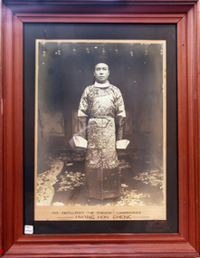
Photograph - Chinese Commissioner, Hwang Hong Cheng,1906, 1902
His Excellency, Hwang Hon Cheng, from Peking, China, visited Australia from 1906 -1907 as Chinese Commissioner in response to an urgent petition from well respected Chinese business leaders, The 1906 Petition was sent to the Chinese Ambassador in Britain requesting the appointment of a Chinese Consular Representative in Australia to ease the escalating Discrimination and address the Immigration Restrictions in Australia. Hwang Hon Cheng visited Brisbane, Sydney, Melbourne , Adelaide and Hobart and after reviewing his recommendations Britain agreed to the appointment of the first Chinese Consul-General to Australia. In 1908 Mr Leong Lan Fun, Taotal of Swatow was appointed Consul-General for the Commonwealth with his headquarters in Melbourne. Animosity, suspicion and misunderstanding had existed between Chinese and European settlers since the Gold Rush of 1850’s. Language, customs, frugality and mostly their ability to obtain profit from crops seen as uneconomical by Europeans eg parsley, garlic and salad vegetables. Many of the Chinese workers did not purchase land instead their main aim was to obtain enough money for their family and return to China. There were a few still managing market gardens around East Bentleigh until the 1950’s, by which time they were highly regarded by the general community. A large photograph of His Excellency the Chinese Commissioner , Hwang Hong Cheng, in a wooden frame c1906His Excellency the Chinese Commissioner / Hwang Hong Cheng, moorabbin, bentleigh, ormond, brighton, gold rush, chinese immigration, chinese market gardeners, markets, cheltenham, cabinet makers, early settlers, pioneers, market gardeners, , hwang hon cheng, leong lan fun, peking china, melbourne -
 City of Moorabbin Historical Society (Operating the Box Cottage Museum)
Document,photocopy plan 'Two Acre Village 'c1852, c1960
In the 1852 Josiah Holloway, a developer, purchased 625 acres from the squatters Richard and John King and sectioned '2 acre allotments' south of Henry Dendy's Brighton Survey along the Arthur's Seat Road ( later Nepean Highway) for sale @ £10 It became known as The Two Acre Village as settlers took up the allotments and established market gardens, general stores, butchers, blacksmiths, post office and 2 hotels. Charles Whorral opened The Cheltenham Inn and it became so popular as a meeting place that the area was called Cheltenham. The early settlers, who were predominantly English and Scottish immigrants initially leased their allotments and, because the sandy soil was so fertile, they were soon able to purchase the land and increase their acreage. Cheltenham became a very important part of the large Moorabbin Shire1871 and City of Moorabbin 1934 In the 1994 Amalgamation of Councils, when the large City of Moorabbin was divided between the newly formed Glen Eira, Kingston and Bayside Councils, the Cheltenham area was assigned to the City of Kingston A photocopy of the Plan for the 2 Acre Village in Moorabbin Parish c1852. A3 laminatedmoorabbin, brighton, cheltenham, market gardeners, pioneers, early settlers, , king. john, holloway josiah, whorral charles, arthur’s seat road, nepean highway , cheltenham inn hotel, henry dendy special survey 1841 -
 City of Moorabbin Historical Society (Operating the Box Cottage Museum)
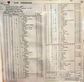
Document, laminated List of Pioneers Moorabbin Parish, c1985
This list shows the names of the Pioneer settlers with the amount of Acres, the date purchased from The Crown and the Lot or Portion Number in the Land of the Henry Dendy Special Survey of Brighton 1841, in the County of Bourke , Victoria. The Squatters ,who arrived in the area first, used the land for grazing sheep and cattle. The Squatters had the right to graze unoccupied Crown land for ₤10 per year rental and a per capita payment for animals grazed. They could develop , improve and clear the land for the purpose of the tenancy but ownership was not permitted. When the land became useful The Crown put it on the market and the developers took over whilst the Squatters lost the improved land, dwellings and out buildings, there being no compensation paid. Squatters named John and Thomas Martin 1840-41; Richard and John King 1840- 1854 ; M.N.M.Moysey and M.J.Bickford 1841-1852 ; James McMahon 1846-1853 ; Daniel MacKinnon 1839- 1840. The 5120 Acres of the Henry Dendy Special Survey 1841were divided into approx. 83 Portions / Lots with varying acreage . Josiah Holloway, a speculator purchased 625 acres of the King Brothers run and re-sectioned the land into 2 acre Lots for Sale as market gardens. It was called The Two Acre Village later known as Cheltenham. A List of the names of The Pioneers in County of Burke Victoria c1841-1887 compiled by Lesley A. Schumer in 1985 A 3 Laminated display on wall in room 2 THE PIONEERS, Signed L.A. Schumer moorabbin, brighton, cheltenham, bentleigh, market gardeners, pioneers, early settlers, dendy henry, henry dendy's special survey 1841, squatters, king john, martin john, mcmahon james, two acre village, holloway josiah, were jonathan binn, grazing, cattle, sheep, market gardens, -
 City of Moorabbin Historical Society (Operating the Box Cottage Museum)
Document, laminated photocopy of 'Plan of Moorabbin 1850', 1853
Weston Bate, 'A history of Brighton' 1962 informs us that in 1840 Henry Dendy, who was a farmer in Sussex England, paid 5,120 pounds sterling @ 1pound per acre for a 'Special Survey of Land in Port Phillip , Australia. Henry arrived in Australia in 1841 on the frigate 'York' with his wife, son, and three servants. He also took advantage of the Government Assistance of Free Immigrants for Survey Purchasers, to help on his estate and persuaded some Sussex men with their families to follow him. However when Dendy arrived in Port Phillip he found that LaTrobe and Gipps were trying to raise the price of land close to Town to 15pounds per acre. Dendy asked merchant J.B.Were to manage his affairs and they went ahead with plans to subdivide the surveyed land called 'The Brighton Estate' This area of land extended easterly from the Port Phillip Bay to East Boundary Road and from North Road to South Road in the Parish of Bourke Victoria. The Privy Council, England , decide that Henry Dendy could purchase the land at 1pound per acre. Land Sales proceeded from 1844 as more immigrants established market gardens, farms and varied businesses in 'Moorabbin'This is a photocopy of a Map of the Moorabbin , County of Bourke c1850 showing the 'Henry Dendy Special Survey 1841'A photocopy of a Map of the Moorabbin , County of Bourke c1850. A3 size laminatedLeft corner : MOORABBIN / COUNTY OF / BOURKEdendy henry, dendy special survey 1841, brighton, moorabbin, ormond, bentleigh, market gardeners, pioneers early settlers, box william, box elizabeth