Showing 369 items
matching engineering building.
-
 Federation University Historical Collection
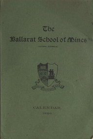
Book, Ballarat School of Mines Calendar, 1903
Contents include: Associateship and final certificates; Calendar for 1903; Discipline; Fees; Full Certificates issued; general regulations: Honorary Correspondents: Office Bearers; Professor and Lecturers; Results of exams; Statistics; Subscriptions and Donations; Subjects included in Regulation Technical Schools; Subjects on Instruction; Subjects included in Associateship course, Time table. Images include: Andrew Anderson, Lecture Rooms (Administration Building), Senior members of staff, School Buildings and Grounds, Linkenbach Table - Battery Laboratory, Engineering laboratory interior, junior Chemistry Laboratory; Assay Laboratory, Battery Laboratory interior, Maddern FurnaceCharcoal soft covered book at 100 pages. ballarat school of mines, andersnon\bickett, vale, warrington rogers, oddie, dunn, figgis, david ham, herman, lindsay, lonie, maddern, middleton, morrison, nevett, pearce, scott, woolcott, wanliss, r.e. williams, henry cuthbert, thomas hart, charles kent, frederick martell, newman, william bailey, hamilton, bechervaise, george russell, thomas bath, r.m. serjeant, peter matthews, theo williams, alfred mica smithh, daniel walker, hubert murphy, charles deane, arthur garrard, valentine anderson, douglas runtin, john balyney, l. cameron, dawbarn, a.e.c. kerr, john adams, edgar mcconnon, hall, john m. sutherland, usher, charles campbell, metallurgy, geology, certificate as mine manager, certificat as assayer, labratory, museum, land and mine surveying, applied mechanics, machine drawing and dedign, mechanics applied to mining, engineering laboratory, electrical department, state school lectures, excursions, mathematics, physics, geometry, photography, chemistry, organic chemistry, assaying, mining gelogy, mineralogy, petrology, algebra, trigonometry, mensuration, land surveying, mine surveying, steam and gas engines, dynamics and heat, sound and light, magnetism and electricity, electrical tecnology, botany, veterinary science, engineering drawing, electroplating -
 Federation University Historical Collection
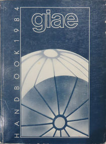
Book, Gippsland Institute of Advanced Education Handbooks, 1970-1985
.1) 1977 Gippsland Institute of Advanced Education Handbook with white cover .2) 1978 Gippsland Institute of Advanced Education Handbook with blue/black cover .3) 1979 Gippsland Institute of Advanced Education Handbook with orange cover .4) 1980 Gippsland Institute of Advanced Education Handbook with yellow/brown cover .5) 1981 Gippsland Institute of Advanced Education Handbook with grey/black cover .6 1984 Gippsland Institute of Advanced Education Handbook with blue cover .7) 1985 Gippsland Institute of Advanced Education Handbook with purple cover .8) 1989 Gippsland Institute of Advanced Education Handbook with white/purple/grey/red/blue cover .7) 1985 Gippsland Institute of Advanced Education Handbook with pale green cover. .9) 1974 Gippsland Institute of Advanced Education Handbook with orangeand white cover .10) 1975 Gippsland Institute of Advanced Education Handbook with green and white cover .11) 1976 Gippsland Institute of Advanced Education Handbook with white cover .12) 1986 Gippsland Institute of Advanced Education Handbook with mid-blue cover .13) 1987 Gippsland Institute of Advanced Education Handbook with red cover .14) 1988 Gippsland Institute of Advanced Education Handbook with red cover .15) 1973 Gippsland Institute of Advanced Education Handbook with brown cover .16) 1972 Gippsland Institute of Advanced Education Handbook with pale green cover .17) 1971 Gippsland Institute of Advanced Education Handbook with mid-blue cover non-fictiongippsland institute of advanced education, giae, gippsland, churchill, morwell, electricty, handbook, gippsland campus -
 Federation University Historical Collection
Plan, Ballarat School of Mines Additional Rooms to Plumbing Shop, by Chief architect Percy E. Everett, 1945, 14/01/1945
.1) Copy of structural details for additional rooms for the Ballarat School of Mines Plumbing Building, 1945 .2) Copy of structural details for additional rooms for the Ballarat School of Mines Plumbing Building, 1945 .3) Copy of an engineering plan for additional rooms for the Ballarat School of Mines Plumbing Building, 1948 .4) Copy of a plan for additional rooms for the Ballarat School of Mines Plumbing Building, 1945ballarat school of mines, plumbing, architectural plan -
 Federation University Historical Collection
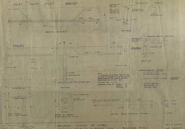
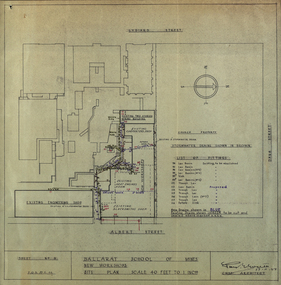
Plan - Plans, Ballarat School of Mines New Workshops, 1944, 17/11/1944
This building has been demolished to make way for new buildings along Albert Street. According to E.J. Barker this was Metal Fabrication.Plans (dyeline) for new building along the Ballarat School of Mines Albert Street frontage .1) Ballarat School of Mines New Workshops .2) as above Scale 1:480 WGS 84 37 degrees 33 feet 54 inches south 143 degrees 50 feet 30 inches eastSheet No 3 F.G.B.ballarat school of mines, metal fabrication, albert street, buildings, plan, heat engines room, model mine, blacksmiths shop, blacksmithing, carpenters shop, engineering shope, percy everett -
 Federation University Historical Collection
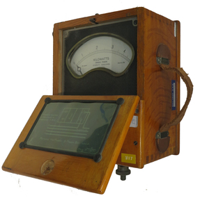
Instrument - Electrical Instrument, Everett AC Wattmeter, 1923
Would have been used by staff and students of electrical Engineering at the School of Mines, Lydiard St. campus up until the start of the Mount Helen campus E building third floor. The meter would have had limited use in classes until 2009. This Wattmeter became part of the historical collection in 2011 after the movement of Engineering out of the E building. In working condition and a good example of early 20th century electrical instruments.A polished natural timber case with partial flip top lid and leather carry handle, housing a single phase AC Wattmeter, rated at 170 volts , 30 amps Scale 0 to 5 kilowatt. Serial no :210088Schematic diagram on inside lid showing how to connect the Wattmeter to measure a 3 phase balanced load. Paper sticker on top "1/92" Information for voltage and current ranges painted with white paint on left hand side by Voltage terminals Voltage terminals labelled A and N Also white on black "W8" on same surface Aluminium plate "67" on right hand side near current terminals which are engraved To A and Ti A to indicate current flow direction Aluminium sticker with Ballarat CAE Electrical Engineering by carry handleeverett instruments, single phase, wattmeter, electrical, scientific instruments -
 Federation University Historical Collection
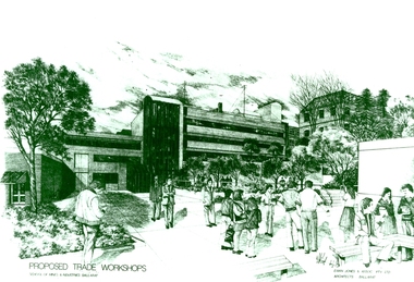
Photograph - Photograph - Black and White, Proposed Ballarat School of Mines Trade Workshops, c1984
A design for a Trade and Art Workshop at the Ballarat School of Mines was prepared by Ewan Jones and Associates on the Albert Street boundary around 1984. The M.B. John Building (Building K), a three storey, face red brick, restrained Late Twentieth Century International styled building with an elongated, cuboid form (defined by the parapeted facades) that is offset by projecting exposed concrete framed, round‐arched entrance and stair wells on the east (Albert Street) elevation (the centrally located entrance breaking the brick façade with glazing). The facades are also characterised by banks of aluminium framed, horizontal ribbon windows, which wrap around the building corners. Metal shades project beyond the windows, while post‐supported bullnosed verandahs and hoods and projecting concrete stairs are other features. On the west elevation, the cuboid façade is punctuated by projecting curved concrete and glazed, elongated bays at first floor level. (David Rowe/Wendy Jacobs) The M.B. John Trade–Art building of SMB was officially opened by the Hon. John Cain, Premier of Victoria, in the presence of Morgan B. John. Programs include 3 Dimensional Art, Painting & Decorating, and Engineering Trades. (SMB Institutional Plan 1989)Black and white photograph of a sketch for the proposed Trade Workshops at the Ballarat School of Mines, from the Albert Street vantage point. This building is known as the M.B. John Building on the SMB Campus.ballarat school of mines, trade workshops, flecknoe, m.b. john, ewan jones and associates pty ltd, albert street, morgan b. john, ewan jones and associates -
 Federation University Historical Collection
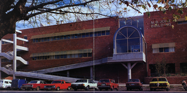
Image - Colour, Ballarat School of Mines M.B. John Building, Albert Street, Ballarat, 1987, 1987
The M.B. John Trade–Art building (Albert Street front) of SMB was officially opened by the Hon. John Cain, Premier of Victoria, in the presence of Morgan B. John. Programs include 3 Dimensional Art, Painting & Decorating, and Engineering Trades. (SMB Institutional Plan 1989) The M.B. John Building (Building K), a three storey, face red brick, restrained Late Twentieth Century International styled building with an elongated, cuboid form (defined by the parapeted facades) that is offset by projecting exposed concrete framed, round‐arched entrance and stair wells on the east (Albert Street) elevation (the centrally located entrance breaking the brick façade with glazing). The facades are also characterised by banks of aluminium framed, horizontal ribbon windows, which wrap around the building corners. Metal shades project beyond the windows, while post‐supported bullnosed verandahs and hoods and projecting concrete stairs are other features. On the west elevation, the cuboid façade is punctuated by projecting curved concrete and glazed, elongated bays at first floor level. (David Rowe/Wendy Jacobs)Image of a multi-storey brick building on the Ballarat School of Mines campus. The building is known as the M.B. John Building.ballarat school of mines, m.b. john building, morgan b. john, albert street, m.b. john -
 Federation University Historical Collection
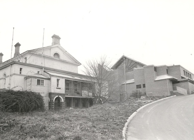
Black and white photograph, Rear view of the former Ballarat Supreme Court, Lydiard Street South, c2004
Black and white photograph of the rear of the former Supreme Court. Built in 1868 as part of the Ballarat Gaol complex, it became part of the Ballarat School of Mines in 1947 and used for Electrical Engineering. It has now been transformed into a performing arts centre. New building shown is Amenities Building and was officially opened in 1981. Radiating beams used for the top window are made from Oregon wood. Thought to be the last building using this wood for this purpose. Drive up to the building comes off Grant Street. All this is part of Federation University - Grant Street Campus.Black and white photograph of the rear of the former Courthouse. Built in 1868, it became part of the Ballarat School of Mines in 1947. New building shown is the Amenities Building. All part of Federation University - Grant Street Campus.ballarat supreme court, ballarat gaol, ballarat school of mines, electrical engineering, performing arts centre, amenities building, oregon cedar, grant street, grant street, federation university -
 Federation University Historical Collection
Book - Ledger, Ballarat School of Mines Minute Book, 1942-1946, 03/03/1942-20/03/1946
The Ballarat School of Mines was established in 1870 and was the first School of Mines in Australasia. Blue hard covered book with brown leather spine and corners. pg 4 - Farewell for Albert W. Steane pg 9 - Instruction in Electrical Engineering pg 30 - The late Cr M. Martin pg 38 - Caretakers Duties pg 40 - The late Cr F. Barrow pg 43 - John Brittain Telescope pg 43 - Martha Pinkerton Bequest pg 66 - Resignation of Albert E. Williams pg 85 - N. Whiteside and Civil Engineering Course pg 128-130 - Technical Education pg 193 - Proposed new buildings pg 272 - Retirement of J.M. Sutherland pg 280 - Proposed change of name to school pg 297 - Woolclassing Room pg. 342 - pg 353 - D. Taylor Kellock pg 353 - Resignatin of Miss Grigg pg 367 - Dr Pern's Collections of Aboriginal Artefacts pg 377 - Inmates of Ballarat Orphanage pg 356 - Ballarat School of Mines Museum contents Loose - Resolutions Passed by Technical Schools' Association of Victoria, October, 1942, with the Minister's Replies.Pg 367 - "Dr Pern's Collection Cr Lederman reported on the proceedings of the special committee meeting held on the 19th February. At that meeting it was suggested that the Ballarat Historical Society might consider transferring their collection to the Museum. It was decided that any expert from Melbourne be invited to come to Ballarat for the purpose of inspecting the mounted birds, which in many instances were falling to pieces, and recommending the best way of dealing with them."m. grigg, t.h. trengrove, building plans, john brittain telescope, new workshops, t. barrow, a.w. steane, martha pinkerton, ballarat school of mines museum, sydney pern, pern collection, ballarat orphanage, thomas aggett, william aggett, sebastian fumberger, peter hogg, ronald irving, eric jackson, ray lear, ken mason, john birch, william gleeson, robert gleeson, robert guyas, ronald holmes, albert king, stuart smith, alan snell, martha pinkerton scholarship, frank pinkerton scholarship, thomas trengrove, d. taylor kellock, architecture course -
 Federation University Historical Collection
Photograph - Photograph - Black and White, M.B. John Building, Federation University SMB Campus, c1992, c1989
Morgan Bevan John was a president of the Ballarat School of Mines for many years. In 2014 the building was used for Ceramics and 3D Art, other former uses now being carried out in the Skills Centre. The M.B. John Trade–Art building (Albert Street front) of SMB was officially opened by the Hon. John Cain, Premier of Victoria, in the presence of Morgan B. John. Programs include 3 Dimensional Art, Painting & Decorating, and Engineering Trades. (SMB Institutional Plan 1989)Two black and white photographs of the MB John building at Federation University SMB campus. The building fronts Albert Street, Ballarat. .2) shows the edge of the Ballarat School of Mines Botanical Gardens.ballarat school of mines, john, ballarat school of mines botanical gardens, flecknoe, m.b. john, vocational skills, morgan b. john, albert street, buildings -
 Federation University Historical Collection
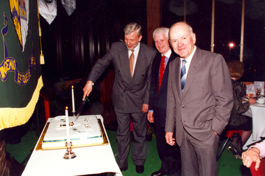
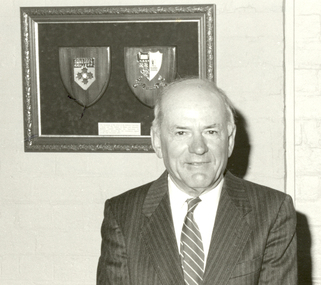
Photograph - Colour, Cutting the Ballarat School of Mines 125th Anniversary Cake, 1995, 1995
The Ballarat School of Mines opened to students in 1870, making it the first School of Mines in Australia. Ballarat School of Mines Council President, Bill Gribble, studied Art at Ballarat School of Mines Technical Art School. In 1956 he was working with Villiers Engineering, then Bendex Mintex in 1966. He retired from there in 1988 as Chairman and Managing Director. In 1989 Bill Gribble was appointed to the Ballarat School of Mines Council. He served as President from 1992 until his retirement in 1996. In that year the Ballarat Technical Art School building was named the W.J. Gribble building. Two colour photographs of the cutting the Ballarat School of Mines 125th Anniversary Cake. Principal Ron Wild is in the centre, with Council President Bill Gribble on the right. The photo was taken in the Amenities building at the Ballarat School of Mines. ballarat school of mines, anniversary, 125th anniversary, ron wild, bill gribble, gribble, ballarat school of mines, anniversary, 125th anniversary, ron wild, bill gribble, gribble -
 Federation University Historical Collection
Photograph - Colour, Bill Gribble Making a Speech at the Ballarat School of Mines, 1995, 1995
The Ballarat School of Mines opened to students in 1870, making it the first School of Mines in Australia. Ballarat School of Mines Council President, Bill Gribble, studied Art at Ballarat School of Mines Technical Art School. In 1956 he was working with Villiers Engineering, then Bendex Mintex in 1966. He retired from there in 1988 as Chairman and Managing Director. In 1989 Bill Gribble was appointed to the Ballarat School of Mines Council. He served as President from 1992 until his retirement in 1996. In that year the Ballarat Technical Art School building was named the W.J. Gribble building. A colour photograph of Bill Gribble making a speech in the Library Courtyard at the Ballarat School of Mines. Vern Robson is on the left and Principal Ron Wild is in the centre.ballarat school of mines, gribble, bill gribble, ron wild, vern robson, robson, ballarat school of mines, gribble, bill gribble, ron wild, vern robson, robson -
 Federation University Historical Collection
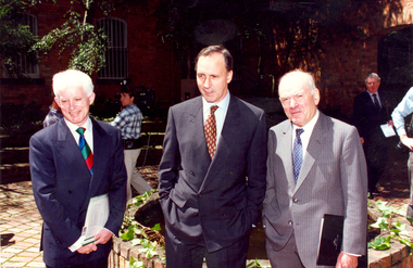
Photograph - Colour, Ron Wild, Prime Minister Paul Keating and Bill Gribble at the Ballarat School of Mines, 1995
Paul Keating laid a stone at the Ballarat School of Mines on 25 October 1995 on the 125th anniversary of the Ballarat School of Mines. Ballarat School of Mines Council President, Bill Gribble, studied Art at Ballarat School of Mines Technical Art School. In 1956 he was working with Villiers Engineering, then Bendex Mintex in 1966. He retired from there in 1988 as Chairman and Managing Director. In 1989 Bill Gribble was appointed to the Ballarat School of Mines Council. He served as President from 1992 until his retirement in 1996. In that year the Ballarat Technical Art School building was named the W.J. Gribble building. Colour photograph of three men in a courtyard of the Ballarat School of Mines. They are from left, Ron Wild (Principal), Prime Minister Paul Keating, Bill Gribble (SMB Council President)ballarat school of mines, paul keating, prime minister, bill gribble, gribble, ron wild, anniversary, 125th anniversary., ballarat school of mines, paul keating, prime minister, bill gribble, gribble, ron wild, anniversary, 125th anniversary. -
 Federation University Historical Collection
Photograph - Black and White, Bill Gribble in Founders Room at the Ballarat School of Mines, c1994, c1994
Ballarat School of Mines Council President, Bill Gribble, studied Art at Ballarat School of Mines Technical Art School. In 1956 he was working with Villiers Engineering, then Bendex Mintex in 1966. He retired from there in 1988 as Chairman and Managing Director. In 1989 Bill Gribble was appointed to the Ballarat School of Mines Council. He served as President from 1992 until his retirement in 1996. In that year the Ballarat Technical Art School building was named the W.J. Gribble building.Two black and white photographs of Bill Gribble in Founders Room at the Ballarat School of Mines.ballarat school of mines, ballarat school of mine council, bill gribble, gribble, founders room -
 Federation University Historical Collection
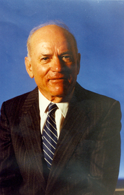
Photograph - Photograph - Colour, William James Gribble, 1996, 1996
Ballarat School of Mines Council President, Bill Gribble, studied Art at Ballarat School of Mines Technical Art School. In 1956 he was working with Villiers Engineering, then Bendex Mintex in 1966. He retired from there in 1988 as Chairman and Managing Director. In 1989 Bill Gribble was appointed to the Ballarat School of Mines Council. He served as President from 1992 until his retirement in 1996. In that year the Ballarat Technical Art School building was named the W.J. Gribble building..1) Portrait of Bill Gribble, President of the Ballarat School of Mines Council .2) Presentation to ill Gribble on his retirement from the Ballarat School of Mines CouncilThe presentation states: "The Council expresses its deep appreciation of the outstanding contribution of William James gribble. During your time as a member of the Council from 1988 and as President from 1992 until 1996 the Institute experienced a significant expansion in progress, enrolments and facilities, faced many challenges and achieved great success. Your dedication , commitment and loyalty to the institute is acknowledge. The vigorous leadership you provided as President of Council ensured the continued development of the Institute as an outstanding provider of technical and further education well placed to face challenges ahead. The Council, Staff and Students wish you well for the future and thank you for your devotion to the good governance of the institute."bill gribble, gribble, w.j. gribble, ballarat school of mines, ballarat school of mines council -
 Federation University Historical Collection
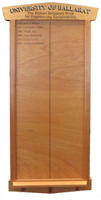
Honour Board, The Pitman Benjamin Prize for Engineering Sustainability Honour Board, c2006
The Pitman Benjamin Prize for Engineering Sustainability is awarded to the Civil Engineering student whose thesis best promotes sustainable engineering. It is awarded in memory of a Heather Pitman, the first woman to graduate in Engineering at Ballarat. The Pitman Benjamin Prize for Engineering Sustainability is sponsored by Benjamin Real Estate, and was first awarded in 2006. Heather was the first female graduate from Ballarat College of Advanced Education and obtained outstanding results. Throughout her career she worked predominantly in local government and for much of that time with the Shire of Ballarat, then the City of Ballarat. During that time she worked as a civil engineer and in planning. Heather was a trail blazer in many respects and was one of the first women to be employed into an engineering position at that time. It was not easy, and she applied for about 200 jobs before being employed by the Shire of Greensborough, north of Melbourne. In 2002 Heather Pitman was Land Development Engineer with the City of Ballarat. The following year she was the City of Ballarat's Manager, Building & Assets. Award sponsor Terry Benjamin was a great mentor of Heather’s sponsoring the award in her memory when she died suddenly at the age of 48. Honour Board, gold lettering University of Ballarat. Black lettering The Pitman Benjamin Prize for Engineering Sustainability. The Pitman Benjamin Prize for Engineering Sustainability has been awarded to: * 2006 - Nathan Whittle; * 2007 - Christopher Quinn; * 2008 - Vinoch Ravi; * 2009 - Troy Vanberkel; * 2010 - Nil; * 2011 - Craig Furniss; * 2012 - Joshua Handreck; * 2013 - Matthew Willis (not on board 10/6/2014); * 2013 - Daniel Camilleri (not on board 10/6/2014);pitman benjamin, nathan whittle, christopher quinn, vinodh ravi, troy vanberkel, craig furniss, joshua handreck, prize, engineering, sustainability, heather pitman, stuart benjamin, benjamin real estate -
Federation University Historical Collection
Book, New York Post, The School of Mine Quarterly: A Journal of Applied Science, 1889-1809
The School of Mines Quarterly was a jpournal of Applied Science from Columbia College, New York City.The Index to the School of Mines Quarterlu Volumes X1-XX (1900) and 32 green covered journals school of mines, new york, columbia college, schools of mines, columbia school of mines, witwatersrand goldfield, inter-continental railway, mine ropes, harbor improvememnts on the pacific coast, glycerine and artificial butter industry, transit factors for teh columbia college observatory, tables for the reducation of transit observations, ancienct methods for dividing and recoording time in japan, assay of tin, john strong newberry, standards of linnear measure, comparison of costs of electric lighting, huanchaca mine bolivia, el callao gold mine venezuela, john magnus adams, ores in saxony, hartz and rhenish prussia, hofmann apparatus, adjustment of trangulation, determination of carbonic acid in white lead, lower coals in western clearfield county pennsylvania, old telegraph mine ningham canon utah, mechanical preparation of ores, modern waterworks construction, curdling of milk, french regenerative gas furnace, irrication canals, peruvian salt mine, collection of metallurgic dust and fume, permeability of iron and steel, assay of silver, explosion in a zinc fume condenser, teaching archtectural history, liquid air, between the mine and the smelter, ballistic galvonometer, assay of telluride ores, analytical chemistry, theory and design of the masonry arch, silver pick mine wilson colorado, telegraphy and telephoney, mineralogy, morse code, michigan mining practices, titaniferous magnetites, paradox of the pantheon, rocks from wyoming, witwatersrand goldfields, gaseous sun, alternating current distribution, engineering tests on direct current electrical machinery, thomas egleston, ore dressing, frederick morgan watson, camp bird gold mine and mills, magnetic properties of iron and steel, morphology of organic compounds, antimony, structure of the starch molecule, cerrillos hills new mexico, geology, rossie lead veins, practical electrochemistry, lines of graphic statics, anistic acid by the ozidation of anniseed oil, bromate method for antimony, john krom rees, trust company of america building, helion lamp, frederick arthur goetze, mine surveying, pine wood oils, malleable cast iron, electrolytic treatment of galena, turpentine and pine oils, bluestone, ashokan dam bluestone, road resistances, oxy-gas blowtorch, mine dumps, segregation of steel ingots, masonry dam formulas, putnam county magnetic belts, gases, continuity of education, hydraulic diagrams, standardistion of potassium permanganate, sewerage discharge into sea water, modern waterworks, true column formula, slags from lead furnaces, missouri river, tempreture of gases, rocks, architectural history, modern dome, oil machine, undulations in railway tracks, irrigation engineering, cleps-tachymeters, electrical engineering, new york shales, fan pump, sucrose, isaac newton, french school of anstronomers, electrolytic polarization, benjamin bowden lawrence, diamond drilling, new york ciy water front, engineering profession ethics -
 Federation University Historical Collection
Photograph - Photograph - Colour, Federation University Gippsland Campus, c1995, c1995
The following information was the preface of the 1985 GIAE handbook: The Gippsland institute of Advanced Education was established by an Order-in-Council in September, 1968, but, owes its origin to engineering diploma courses established in 1928 to service the developing electrical industry. The Council of the Institute includes members of the Gippsland community who are prominent in industry, commerce, education and the professions, the Director of the institute, the representative of the academic staff, of general staff, of students and of the Convocation of the Institute. In 1972 the Institute occupied the first of its permanent buildings on a large campus in rural surroundings near the township of Churchill, ten kilometres south of Morwell and one hundred and sixty kilometres east of Melbourne. Engineering laboratories are temporarily located in buildings on the site of the Yallourn College of TAFE at Newborough and they will be consolidated on the Churchill campus by the end on 1985. In 1974 new buildings were completed under a self-help program to house the School of Visual Arts. A building complex to provide the first stages of the permanent library and the Union, and accommodation for the School of Business and Social Sciences was completed in 1976. An Education building, an Applied Science building and student residential buildings for 108 student places were completed at the beginning on 1976. The Binishell, a multi-purpose facility was completed in 1980. On its establishment, the Institute assumed responsibility for the diploma courses which were previously offered by the Yallourn Technical College. These were diploma in Civil, Electrical, and Mechanical Engineering, Applied Chemistry, and Business, all of which were recognised by the appropriate professional bodies. The Gippsland Institute of Advanced Education is the only centre of Higher Education east of Melbourne and offers a range of vocational courses at associate diploma, diploma, degree, graduate degree and master levels to meet the educational needs of the Gippsland regions. The institute also has a very large commitment to a program on external studies. Federation University Australia was established on 1 January 2014. Formerly known as the University of Ballarat, its enabling legislation was the University of Ballarat Amendment (Federation University Australia) Act 2013. Although formally created as a University in 1994, the University of Ballarat had a lineage back to 1870 with the establishment of the School of Mines Ballarat, making it the third institution of higher learning to be established in Australia and the first to be established in regional Australia. On 1 January 1994, Ballarat University College became the University of Ballarat and in 1998 the University merged with three TAFE Institutes to become a dual sector institution with multiple campuses. On 1 January 2014, the University of Ballarat amalgamated with the Monash University Gippsland Campus to form Federation University Australia. The Gippsland Campus also had a long lineage dating back to 1928 with the establishment of the Yallourn Technical School which became a predecessor institution to the Gippsland College of Advanced Education formed in 1968. In 1990, it was renamed the Monash University College and in 1993 became the Gippsland Campus of Monash University. Large photograph adhered to foamcore showing an aerial view of the Federation University Gippsland Campus at Churchill, Victoria as it was c1995.churchill, gippsland campus, gippsland institute of advanced education, federation university, yallourn, morwell, binishell -
 Federation University Historical Collection
Document - Newsletter, Miners Write: Ballarat School of Mines Staff Newsletter, 1994-1997, 1994-1997
The Ballarat School of Mines is a predecessor institution of Federation University Australia. Photocopied newsletters with numerous newspaper clippings. 20 June 1994 - Mission, Women's Policy, Kate Wait, Walter Haller, Stewart Moors, Cynthia Jardine, Mark Lynch, R.J. Young Scholarship, David Thomas 22 August 1994 - Wimmera Community College Agreement, SMB/University of Ballarat Affiliation Agreement Signed by Chancellor Geoffrey Blainey, Max Palmer, Matthew Barlow, Mark Dawe, Phillip Lee, John Conaughton, Elizabeth White 05 September 1994 - Employment White Paper, Workcover, Ross Furness, Nance Jeffreys, Keith Chase, Michael Ronaldson, Ron Wild, Paul Jenkins 25 October 1994 - Staff Consultation Committee, Bendix Mintex Award, Rick Williams, Mike Hickey, Sexual Harassment, Ann McCaffrey, Brewery Complex building 07 November 1994 - Karpin Report, Edgar Bartrop Scholarship, Winsome McCaughey 13 June 1995 - Female Participation in TAFE, Lake Bolac Visit, Virginia Fenelon, Hairdressing, Ararat Community College, Brian MCLennan, Forestry Industry Contract, Ararat PRison Education, E.J.T. Tippett Award, Shane Lake, SMB Graduates 1995, Tony Leonard, Colin McCurry, Steph Pilmore 26 June 1995 - Child Care Centre, computer survey responses, Ellimatta, Sharna Whitehand, Jack Veeken, John Hanmer, Aaron Block, Kirsten Martin, Rowena Worth, Jan Croggon, Andrew McEvoy 24 July 1995 - Teaching, Engineering Liaison, Graham Shearer, Carol Durant, Brian McLennan, Market Research, Ararat Campus, Kevin Martin, Myrtle Muir, Hairdressing, Carol McDonald 07 August 1995 - Childcare, Playgroup, Disabilities, Judy Mills, Former Ballarat Gaol, Private Providers, Equal Opportunity, Equal Employment Opportunity 04 September 1995 - Keith Boast, Barkly Street Campus Library, Barrie Firth, Yuille Street Building, Painting and Decorating, Bricklaying, Disability Forum Committee, Belinda Morgan, Fay Guinane, Olivia Guinane, Robert Clarke Community Centre ceramic Tile Mosaic, Neville French, Annelies Egan, Judith Davies, Tanis Yuille, Margaret Komishon, Ruth Zegir, Ray Isaac 18 September - Competition Policy, Public Sector Reform, Brewery Building contract to S.J. Weir, Ararat Campus, BHP, Peter Bell, Mining Industry, Horticulture Facility (Gillies Street), Creche Fairy Mural, Shellagh Kentish, Daylesford Neighbourhood House and Learning Centre, Jenny Beacham, Tom Bates, Colin Trembath, Alan Scanosio, Zaiga Svanosio 16 October 1995 - Rural Studies Staffing, Robyn Greig, Ross Holton, Virginia Fenelon, Michelle Loader, Christina Elshaug, Cynthia Jardine, Morgan B. John death, Ian Pym, Melissa Cameron, hairdressing, Woolshed, Great Southern Woolshed, Graham Shearer October 1995 - Employment Relations Update, Enterprise Bargaining, Sue Wright, Ron Wild 30 October 1995 - 125th anniversary, 125th anniversary Medallions, Bill Murray (died 28 October 1995), Metal Fabrication, Ron Wild, Gael Ramsay, Paul Keating 20 November 1995 - Ceramics Exhibition, Heather Campbell, Marion Byass, Barry Norman, Helen Knowles, Michael Bracher, Brian McLennan, Rural Studies, Carpark, David Nicholson, Linetter Penhall, Suzanne Brown, Marie Bedggood 27 May 1996 - David Brown Farewell, Keith Boast, Educational Services, Wally Gradkowski, Dzintra Crocker, World Wide Web, Ann McCaffrey 17 June 1996 - Lifelong Learning Through Vocational Education and Training, Lyndal Cooper, Engineering Studies, David Manterfield, Rod MacKinney 19 August 1996 - SMB Strategic Plan 1997-2001, Ian Harris, Ararat Prison Education, Moongate 06 September 1996 - Tom Johnson, Bill Gribble, Ron Wild, INternational Projects Report, Cas Anderson, Court House Theatre, Former Court House, The Moongate 11 November 1996 - Brewery Complex Opening by Prime Minister John Howard on 09 December 1996, Human Resources, Marie Kerr, Fran Kisler, Karen Neale, Trudy Horwoood, Graham Hankin, Engineering Studies, David Manerfied, Sheilagh Kentish, Goroke College 12 May 1997 - Ballarat Group Training, Ballarat Aboriginal Co-operative, SMB Flexible Learning Centre, E.J. Tippett Library, Changing Role of the TAFE Teacher, Maree Greig, Colin Prowse, Performing Arts, Dave Knowles, Karyn Kilroy 20 August 1997 - Amalgamation Update, Graham Paynter, Heather MacLeod, Performing Arts 05 September 1997 - From TAFE to VET, Leoda Atkinson, Daniel James, Ararat campus, Mark Bevelander, computers, Craftsmanship Awards, Koorie Programs Unit, Deanne Jakiel, Stephen Burns, Women's Access Program, Internet 20 October 1997 - amalgamation update, Flexible Learning Centre, Andrea Bateman, Val D'Angri, Leoda Atkinson, Paul Mason, Andrea Bateman 10 November 1997 - Ballarat School of Mines/University of Ballarat Amalgamation, Shenzhen Polytechnic China, Videoconferencing, John Ferrier (Science), Performing Arts 08 December 1997 - Last Edition of Miners' Write Ron Wild, Brian McLennan, Max Palmer, Jeanetter John, Farewell to SMB, Time Capsuleminers write, ballarat school of mines, ron wild -
 Flagstaff Hill Maritime Museum and Village
Document - Navigation Chart, Admiralty Office, Lady Bay and Warrnambool Harbour, 1893
This navigation cart of Lady Bay and Warrnambool Harbour was originally surveyed in 1870 but this version includes the update for magnetic variation in 1893. Since the printing of the chart several annotations have been added. These include an additional stamp dated 15-8-1910, a handwritten comment across the top of the page dated August 1910, and another handwritten comment regarding the ‘Proposed Extension of Dock’ dated 19-2-1925, plus connected drawings, notes and figures. The 1925 proposal on this chart may have been a reaction to the Royal Commission of 1923, when the damaged stonework on the seaward side of the Warrnambool Breakwater, caused by the action of the sea, was the subject of enquiry. A conference between the Public Works, Water Commission and the Harbour Trust concluded that it would less costly to make repairs to prevent further damage rather than replaced the damage portion of the wall. A contract was raised in late 1924 to deposit rubble on the damaged side of the breakwater to minimise the Southern Ocean’s destructive action and work had started by August 1925. The Breakwater construction had begun in 1874 and was completed in 1890. The Victorian Government had commissioned Sir John Coode, a British harbour engineer, to present a plan to complete the Warrnambool Breakwater but his original plan was too expensive. He prepared a revised plan for a shorter structure. The construction proved to be too short to protect adequately from the weather and didn't allow enough depth for larger vessels to come into port. The decreasing trade was further affected by siltation in the bay due to the breakwater, and the completion of the railway line. The situation of the harbour became a real problem by 1910 and required continuous dredging. In 1914 the Breakwater was extended but proved to be a failure because the work began to subside and by 1920 about two thirds of the harbour was silted up. Alterations made in the 1920's increased the silting problem and by the 1940's the harbour was no longer used. More alterations were made in the 1950's and 1960's. This chart is significant for its strong connection to the maritime history of Warrnambool Harbour and Lady Bay and the Warrnambool Breakwater. The Warrnambool Breakwater is registered as a place of significance on the Victorian Heritage Database (VHR H2024). The Warrnambool Breakwater is one of the most important late 19th century maritime engineering projects in Victoria and significant in the development of Victorian coastal shipping. It is also significant for its connection with British harbour engineer, Sir John Coode. The chart is a historical record of structures existing in 1893; the Warrnambool Jetties, Warrnambool Breakwater in Lady Bay, the leading lights (lighthouses), streets, roads, bridges and many buildings. It also shows the lay of the land and seabed. Navigation Chart: Lady Bay and Warrnambool Harbour, Australia - South Coast - Victoria. Surveyed by Nav. Lieut. H.J. Stanley, R.N., 1870. Updated for Magnetic Variation, 1893. The rectangular chart is printed on heavy cream paper. Stamps are shaped rectangular, oval and round. Around the Breakwater and Jetty area are handwritten notes, dotted and joined lines, numbers and signatures, and shading of red and green. The chart shows the surrounds of Warrnambool Harbour, Lady Bay, the Breakwater and Jetty, roads, bridges and the streets in Warrnambool. It has sounding details, and angles of line from the leading lights.Stamp, rectangular, including "AUG 1910" Stamp, double oval " - - - -CHART" Stamp, hand drawn, red circle, with "B" inside Hand written note "22-8-1910 - - - - - of surveying C. Ca - - - request of 15-8-10 [initials] " Notes and lines in red pen, including a grid of sounding numbers: "1300" "1050" "1200" "Possible Extension of Dock" "19-2-25" "Dock Dredged to 20 Ft" Notes and lines in blue pen "Extension of Dock to accommodate vessels drawing 20 Feet" and "Light not visible south of this line" Red dots (4) with yellow highlight at both leading lights, breakwater and jettyflagstaff hill, warrnambool, flagstaff hill maritime museum & village, maritime museum, maritime village, shipwreck coast, map, chart, navigation chart, plan, lady bay, warrnambool harbour, port of warrnambool, breakwater, jetty, pier, dock extension, proposed extension, vhr h2024, 1870, 1893, 1910, 1925, warrnambool town late 1800s, warrnambool streets late 1800s royal commission, 1923, public works, water commission, harbour trust, victorian harbours, sir jon coode -
 Flagstaff Hill Maritime Museum and Village
Machine - Treadle Lathe, 1920-1923
The lathe-making business incorporated in 1902 as Drummond Bros Ltd originated in the fertile mind of Mr Arthur Drummond, said to have been living at that time at Pinks Hill, on the southern edge of Broad Street Common, west of Guildford. Mr Drummond, whose accomplishments included several pictures hung in the Royal Academy, was unable to find a lathe suitable for use in model engineering. In 1896 he designed for himself a ‘small centre lathe … which had a compound slide rest with feed-screws and adjustable slides’. He also designed and built ‘lathes of 4.5 inch and 5 inch centre height, which had beds of a special form whereby the use of a gap piece was eliminated but the advantages of a gap-bed lathe were retained’. Assisted by his brother, Mr Frank Drummond, who had served an apprenticeship to an engineering firm at Tunbridge Wells, the first lathes were made in a workshop adjoining Arthur Drummond’s house. The demand that speedily built up led to the decision to form a company and manufacture the lathes for sale commercially. Land was acquired nearby, at Rydes Hill, and the first factory built. The enterprise was a success, and the company quickly established ‘a high reputation in this country and abroad for multi-tool and copying lathes, and gear-cutting machines’. Other lathes were added to the range, including the first of the ’round bed’ machines for which the firm became widely known. A Drummond 3.5 inch lathe was among the equipment of Captain Scott’s 1912 expedition to the South Pole, and large numbers of 3.5 inch and 4 inch designs were exported to Australia, Canada and India. By the outbreak of war in 1914, 5 inch, 6 inch and 7 inch screw cutting lathes, arranged for power drive, were on sale. Large orders were received from the government for 3.5 inch lathes, for use in destroyers and submarines, and 5 inch lathes for the mechanised section of the Army Service Corps. The latter were used in mobile workshops. The factory worked night and day to supply the forces’ needs, until production was disrupted by a fire which destroyed a large part of the works in May 1915. As soon as rebuilding was complete work restarted. At the end of the war the entire production was being taken by the Government departments, a special feature being a precision screw lathe, bought by the Ministry of Munitions in 1918. Between the wars Drummond Bros Ltd introduced new machines for the motor vehicle, and later the aircraft industry, and the works were extended on many occasions to fulfill the increasing orders. The Maxicut multi-tool lathe (1925), designed for high-production turning operations, was one of the first machines of this type to be built in England. It was followed (1928) by an hydraulic version for turning gear blanks, and similar work. Further developments provided machines which, during the Second World War, turned all the crankshafts and propeller shafts for Bristol engines. Others, ordered by the Ministry of Supply were employed in turning shells, and many other specific needs of vehicle and aircraft manufacture were catered for by new types of Drummond lathes. Production of the small centre lathes ceased during the war when the company needed to concentrate on building multi-tool lathes and gear shapers. After the war a completely new Maxicut range was introduced, replacing the older versions, and fully automatic. The types were continually developed, and new versions manufactured until the end of the company’s life in 1980. The disappearance from the scene of Mr Arthur Drummond in 1946, and the end of the company’s autonomous existence in 1953 when the company was acquired by William Asquith Ltd, which was in turn bought by Staveley in 1966, meant that the factory at Rydes Hill became one – albeit very effective – part of a large national engineering company. Achievements at the Guildford works during its last years included the development of automated Maxicut gear-shapers in what was ‘probably the most fully automated gear shop in the country’, while a machine from Guildford was sent to the Osaka Fair in 1962. In 1963 an agreement was signed with Hindustan Machine Tools for the manufacture of Maxicut gear-shapers in state owned factories in Bangalore and Chandigarh. During 1963 the two largest multi-tool lathes ever made in the UK were installed in Ambrose Shardlow’s works in Sheffield for handling cranks up to 14 foot long. In 1976 Drummond lathes were included in Staveley’s £14,000,000 installation in Moscow of an automated production line for Zil motor cars. Up to the end invention continued at Guildford: a new Drummond Multi-turn memory-controlled machine was shown at the International Machine Tool Exhibition in 1977. This could not save the works from the pressures of the late 1970s, and Staveley Industries closed its Guildford site in 1980.An early example of a lathe that was designed primarily for the hobbyist model maker. It is in good condition and sought today by collectors as many of it's attributes were innovative at the time and lead to further development and incorporation of some of its features into more industrial models of production machinery. Lathe, round bed, treadle powered lathe, Drummond Type A, Serial number and maker's inscription. 1920-1923, Made by Drummond Brothers in Guildford, Surrey, England. Lathe is complete with Chuck, Tool post and Tail Stock in situ (30 extra parts)"MADE BY DRUMMOND BROTHERS LIMITED - PATENT TEES - RYDE'S HILL n GUILDFORD SURREY", "Serial Number 01470," "L44" or "L45 " flagstaff hill, warrnambool, shipwrecked coast, flagstaff hill maritime museum, maritime museum, shipwreck coast, flagstaff hill maritime village, great ocean road, lathe 1920-1923, round bed lathe, treadle lathe, drummond type a, guildford surrey, drummond brothers guildford surrey england, tread'e -
 Flagstaff Hill Maritime Museum and Village
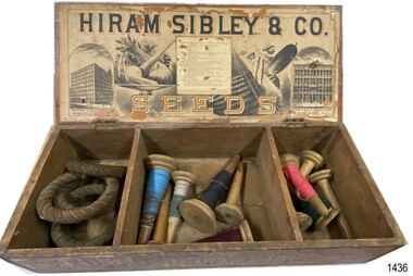
Container - Box for seeds, ca. 1880s
This seed box was made for Hiram Sibley for his seed house business. He sold seeds priced by the weight or the space they took up e.g. bushel. This box allowed for seeds to be divided by type, size or even date. The box was strong and easy to cart and store. It was also a handy item to 'recycle' as a storage container for other items. The Sibley seed box is a desirable collectors' item. A large variety of sizes and shapes are still available today in various stages of condition. Hiram Sibley developed seeds that were strong and the plants that grew from these seeds produced many seeds. Varieties of Sibley seeds and plants are still advertised for sale in modern times. HIRAM SIBLEY (1807-1888) - Hiram Sibley was born in America. He had a natural mechanical ability and became skilled in many trades. He and his partner Don Watson opened a sawmill then a machine shop and foundry. He became involved with Alfred Vale and Samuel Morse and their work on the telegraph. Eventually he became the first president of the Western Union Telegraph Company. Later, after leaving Western Union in the early 1860s, Sibley bought and sold railroads, manufactured sold, ran timber mills, and became involved in farming and seed supply. In this area he used his skills to engineer seeds that were stronger and develop plants that produced more seeds. The production of seeds became his main business. He bought land cheaply and improved to soil so that he could produce seed and grain, and graze herds of cattle. He became the owner of 14 large farms. Hiram Sibley earned the reputation "as the most extensive farmer and seedsman in this country". The business of Hiram Sibley & Co. was conducted his warehouse in Rochester and his seed house in Chicago. One department of the business sold farming equipment, another department imported ornamental plants from overseas countries Sibley went on to invest a large amount of money in a bank, and to be financially involved in the community by making large donations to public services such as a library and a school of music. At one point he was the richest man in Monroe county.This box is significant for its historic connection with Hiram Sibley, who is famous for many reasons, among which is his very profitable business of seed engineering to improve the production of crops. This box also represents the value of containers used for selling products in the 1880s, being re-used for other useful purposes. The box is an example of goods imported for use in Australia. The text and images of the box are an example of 1880s advertisingBox, wooden, with two brass hinges joining lid to base. Base has two wooden partitions, divided into three unequal sized compartments. Lid's underside has label with drawings of buildings and produce, text with maker's name and description of vegetables. Front edge of box has stencilled text and diagrams. Outside lid, and the other three sides, have no inscriptions. Made by Hiram Sibley & Co., USA. (Box is currently used to store quoits 1436.2 and cones of cotton thread 1436.3.)Marked "HIRAM SIBLEY & CO / SEEDS", "WAREHOUSE - "ROCHESTER N.Y. ", "SEED HOUSE - CHICARGO, ILL.", "SEEDS BY WEIGHT & MEASURE", "PUT UP BY / HIRAM SIBLEY & CO. / ROCHESTER, N.Y. AND CHICARGO, ILL."flagstaff hill, warrnambool, maritime village, maritime museum, flagstaff hill maritime museum & village, hiram sibley & co, rochester n.y., seeds, wooden seed box, seed box, seedsmen, arable farming, chicargo illinois, seed house, seed engineering, seed distribution, seeds by weight and measure -
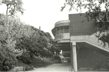
Federation University Historical Collection
Newsletter, Genesis: The Dynamics of the Developing Campus Ballarat Institute of Advanced Education Mount Helen, 1971, 07/1971
Two photocopies of July 1971 edition of 'Genesis'.mount helen campus, wendouree charitable fund, timken international fund of canton, ohio, e.j. barker, student housing, student residences, student housing precinct stage 1, e.j. barker library, buildings, applied science building, student union building, wlaker and jackson, history of the mount helen site, l.h. vernon and associates, r.n. and j.e. greenbank, landscape, australian natives association, ballarat institute of advanced education, computer centre, i.c.l. 1901a computer system, chemistry acquisitions, metallurgy acquisitions, physics acqiusitions, electrical engineering acquisitions, mechanical engineering acquisitions, centenary appeal, new courses -
Federation University Historical Collection
Book, Skeat, William Oswald, Degree Problems in Soil Mechanics and Foundation Engineering, 1977, 1977
This copy of the Planning and Environment Act was used by Creswick Engineer Brian SchreenanRed and blue soft covered book. brian schreenan, structure, building, engineer, structural engineer -
Federation University Historical Collection
Book, The Elements of Structure: An Intriduction fo the Principals of Building and Structural Engineering, 1970
... Principals of Building and Structural Engineering...: An Intriduction fo the Principals of Building and Structural Engineering ...Blue soft covered book engineering, brian shreenan, foundations, columns, arches, slabs'dam walls -
Federation University Historical Collection
Booklet, Gippsland Institute of Advanced Education External Studies, 1977, 1977
Federation University Australia was established on 1 January 2014. Formerly known as the University of Ballarat, its enabling legislation was the University of Ballarat Amendment (Federation University Australia) Act 2013. Although formally created as a University in 1994, the University of Ballarat has a lineage back to 1870 with the establishment of the School of Mines Ballarat, making it the third institution of higher learning to be established in Australia and the first to be established in regional Australia. On 1 January 1994, Ballarat University College became the University of Ballarat and in 1998 the University merged with three TAFE Institutes to become a dual sector institution with multiple campuses. On 1 January 2014, the University of Ballarat amalgamated with the Monash University Gippsland Campus to form Federation University Australia. The Gippsland Campus also had a long lineage dating back to 1928 with the establishment of the Yallourn Technical School which became a predecessor institution to the Gippsland College of Advanced Education formed in 1968. In 1990, it was renamed the Monash University College and in 1993 became the Gippsland Campus of Monash University. In 2016, Federation University Australia announced plans to take possession, over a two-year period, of Monash’s Berwick Campus in the south-east corridor of Melbourne. Federation University Australia, or FedUni, is headquartered in Ballarat and offers programs in Higher Education and Vocational Education and Training to regional Victoria and beyond. The University’s commitment to educational and social equity, teaching excellence, research distinction, environmental sustainability and regional capacity building has enabled it to develop in a way that draws on its proud heritage to inform its future. Its regional character sets a framework for the University’s priorities but does not constrain it from serving wider community interests, nationally and internationally. The name Federation University Australia was chosen to convey the scope and capacity of an expanded regional university with a federated network of campuses.Soft covered booklet with an image of the area known as 'The Knuckle'. 30 pages. The booklet outlines semester offering, calendar, general information, enrolment form, and academic staff.gippsland institute of tafe, churchill, exteranal studies, external studies, applied science, arts, welfare studies, business studies, teacher education, librarianship, engineering, j. milton-smith, h.h. rappaport, r.h.b. tonkin, m.j vertigan, r.w. boyd, m.m. chakera, p.v. morgan, m.j. crowley, w.j. battersby, i.a. gibson, b.e. colebourne, n.c.w. courtney, m. griffiths, r.n. hanley, g.t. smart, g.b. nath, p.r. rayment, r.m. box, m.j. krautschneider, a.j. rahilly, p. farago, p.c. kerr, i.m. montgomery, a.k. pal, c.o fraser, a.k.a. rahman, d.e. nation, i.v. hamilton, a.j. peterson, a.m. robinson, p.k. roy, v. sabrinskas, j.r. lawry, b.m. deakin, l.j. cartledge, g.w. dettrick, k. frost, l.g. gordon, f.x. roberts, h.b. yee, b.r. groves, n.w. terrill, b.t. dunstan, keith hamilton, j.a. harris, p.j. higgins, r.j. hodges, m.a. hooper, s.g. abbott, h. edmonson, t.w. nest, j.c. ochsenbein -
 Federation University Historical Collection
Photograph - Photograph - Colour, Ballarat School of Mines M.B. John Building
On 11 June 1987 The M.B. John Trade–Art building (Albert Street front) of SMB was officially opened by the Hon. John Cain, Premier of Victoria, in the presence of Morgan B. John. Programs include 3 Dimensional Art, Painting & Decorating, and Engineering Trades. (SMB Institutional Plan 1989)Colour photographs of the Ballarat School of Mines M.B. John Building on Albert Street, Ballarat. Some images show the Ballarat School of Mines Botanical Garden.ballarat school of mines botanical garden, m.b. john building, ballarat school of mines, morgan b. john, m.b. john, morgan bevan john, trades -
 Federation University Historical Collection
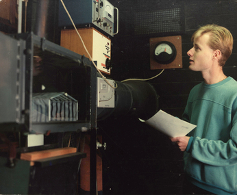
Photograph - Colour, Ballarat College of Advanced Education: Engineering Student, c1980s
... Building mt helen engineering electrical engineering ballarat ...Photograph of student of electrical engineering at Mt Helen - E BuildingColour photograph mounted on boardmt helen, engineering, electrical engineering, ballarat college of advanced education -
 Federation University Historical Collection
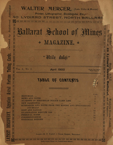
Booklet, Ballarat School of Mines, Student Magazine, April ,1900, 04/1900
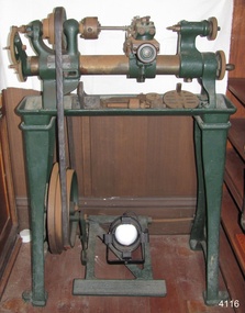
Soft covered magazine of 14 pages. Articles include: News and notes, Glimpses of Rhodesian Police Camp Life, New Caledonia, Summaries and notes from the mining and engineering journals, Boot and saddle, Examination results 1899, Personal notes, Correspondence, Editorial Notes.news and notes, glimpses of rhodesian police camp life, new caledonia, summaries and notes from the mining and engineering journals, boot and saddle, examination results 1899, alumni, john dunstan, prof. horwood, alex purdie, c. f. eeles, d. w. r, arthur, r. j. allan, b, reid, a. s. burdekin, g. mcintyre, c. a. m. deane, mining education, ballarat school of mines rifle club, phoenix foundry model locomotive engine, mining laboratory building, rhosesian police camp life, c.a.m. deane, railway locomotive -
 Federation University Historical Collection
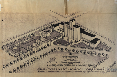
Plan, Ballarat School of Mines Future Development: A Southern Terminal to Lydiard Street, 1947, 09/12/1947
In 1947 Percy Everett, Chief Architect for the Victorian Government, drew up plans to accomodate the growth in student numbers on the Ballarat School of Mines site. It was an era of government buildings surrounding the Ballarat School of Mines campus either being transfered to the school or foreshadowed for transfer. In 1947 two Red Cross huts were transferred from Victoria Park to the western side of the former Ballarat Supreme Court (later Courthouse Theatre) for use by Wool Classing and Motor Mechanics. In the same year additional facilities were provided for Pottery due to the increase in enrolments and a large brick classroom was built at the rear of the Ballarat Junior Technical School Building. In the annual report of 1947 the President said: "These transfers are, however, only temporary expedients and indicate the pressing need for more buildings of a permanent nature". By the end of the year the School Council decided to request the Education Department of Victoria to proceed with the implementation of the School's long-range plan whch had received approval earlier and to treat it as an urgent post-war requirement. After much communication a plan for a six-storied building, flanked by two three storied buildings was planned to be built on the site of the Ballarat Gaol was developed. The plan was sent to the Education Department for the Minister's Approval. It is not know if approval was granted, but the building did not proceed, possibly becausse the Ballarat Gaol was still very miuch in use. When a tertiary division of the Ballarat School of Mines was being developed in 1967 it corresponded with the closure of the Ballarat Gaol. It was determined that the Lydiard Street South site had no room for future growth so a new campus was sought. The new campus was purchased at Mt Helen, and was initially known as the Ballarat Insittute of Advanced Education. In 1976, when the Ballarat Teachers' College merged into the structure, the campus became known as the Ballarat College of Advanced Education and it was no longer a part of the Ballarat School of Mines. Plans for a proposed building to replace the Ballarat Gaol buildings. The proposed building was never built, the concept being replaced by a new teritary facility at Mt Helen. buildings, percy everett, ballarat school of mines battery, ballarat technical art school, engineering workshops, machine shop, ballarat junior technical school, architectural plans, ballarat school of mines, smb campus