Showing 1278 items
matching forest road
-
 Forests Commission Retired Personnel Association (FCRPA)
Beechworth FCV District office sign
... , building and maintaining forest roads, provision of recreation..., building and maintaining forest roads, provision of recreation ...This sign proudly hung outside the Forests Commission Victoria (FCV) Beechworth office which is now site of the Forestry Heritage Museum. The granite building in the Beechworth's historic precinct was once the Gold Warden's Office and is one of the town's original buildings. The FCV was the main government authority responsible for management and protection of State forests in Victoria between 1918 and 1983. The Commission was responsible for ″forest policy, prevention and suppression of bushfires, issuing leases and licences, planting and thinning of forests, the development of plantations, reforestation, nurseries, forestry education, the development of commercial timber harvesting and marketing of produce, building and maintaining forest roads, provision of recreation facilities, protection of water, soils and wildlife, forest research and making recommendations on the acquisition or alienation of land for forest purposes″. The Forests Commission had a long and proud history of innovation and of managing Victoria's State forests but in September 1983 lost its discrete identity when it was merged into the newly formed Victorian Department of Conservation, Forests and Lands (CFL) along with the Crown Lands and Survey Department, National Park Service, Soil Conservation Authority and Fisheries and Wildlife Service. After the amalgamation the management of State forests and the forestry profession continued but the tempo of change accelerated, with many more departmental restructures occurring over the subsequent four decades. Responsibilities are currently split between the Department of Energy, Environment and Climate Action (DEECA), Forests Fire Management Victoria (FFMV), Parks Victoria, Melbourne Water, Alpine Resorts Commission, the State Government-owned commercial entity VicForests and the privately owned Hancock Victorian Plantations (HVP).Large office sign. Hand painted in traditional FCV mission brown and gold colour scheme.forests commission victoria (fcv), forest signs -
 Bendigo Military Museum
Pamphlet - SHIPS MENU, 5 Sept 1919
... Rd, West Hampstead London, Maud Heightley, 33 Disraeli Road... Disraeli Road, Forest Gate E.7 Essex England” Menu card HMAT ...Items relate to "W D S BURNS" No 56 Provost Corpr AIF. Refer Cat No 2076.3P for his service details.Menu card HMAT INDARRA detailing 10 dinner items. At top AUSN Line in red & small blue / red flag representation underneath at L. Printed in black at top: “HMAT INDARRA Captain A.W. Newberry Sept 5th 1919” On rear in pencil: “Ms Banks, 39 Pandora Rd, West Hampstead London, Maud Heightley, 33 Disraeli Road, Forest Gate E.7 Essex England”hmat, menu, 56 provost aif, w d s burns -
 Whitehorse Historical Society Inc.
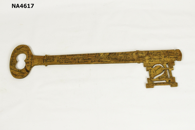
Functional object - Key - 21st, Approx August, 1935
... in Husband Road, Forest Hill, was attended by many well known local... parents home in Husband Road, Forest Hill, was attended by many ...This is the twenty-first key presented to Ronald Arthur Edwards in August 1935. The celebration, held at his parents home in Husband Road, Forest Hill, was attended by many well known local people who signed his birthday key. Ronald Edwards was the youngest child of Arthur and Martha Edwards. In 1929 aged 15 he contracted poliomyelitis and became an invalid. He died in 1955 at Forest Hill.This item is significant in the history of Forest Hill as all the attendees and Ronald Arthur Edwards are from the pioneering families of the area of the Shire of Nunawading.Large wooden plywood key made to celebrate the 21st birthday of Ronald Arthur Edwards in August 1935. Written on handle end in pen Ron Edwards 21st - 19.Key end signed Anna Course, Herbert Course, R.J. Bird, D.J. Bogle.Reverse side R. Course, A.H. Course, Aunt Corrie, F. Bogle, Aunt Harriet, Marjory Course, S. Edwards, Edwards, H. Edwards, E. Edwards, Doug Edwards, Charlie Course, Jean Course, Tom Bailey, H.S. Tainton, N. Tainton, ?Luen Edwards, C.W. Bird, ?S.U. Course, J. Porter, Bob Course, J.E. Bird, M.P.? Course, ?Edwards, L. Tainton, J. Bird, Shirley Edwards, H. Edwards, Ed, A.E. Edwards, Albert H..., V. Edwards, F. Smith, W. Smith, L.James, E. Galley ?, A.E. Edwards, Mother and Father. Gold traces on one side; 21 carved out in key end.See Descriptionhandcrafts, woodwork -
 Whitehorse Historical Society Inc.
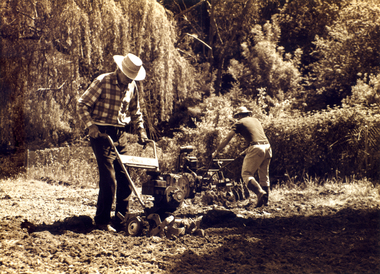
Photograph, Archibald McArthur`
... in Canterbury Road , Forest Hill.Eastside Plants established a plant... in Canterbury Road , Forest Hill.Eastside Plants established a plant ...Archibold McArthur originally owned 6 acres and produced flowers which were sold at the Victoria Market, and vegetables which were sold at a roadside stall outside his property in Canterbury Road , Forest Hill.Eastside Plants established a plant nursery as p[art of the property in 1979 and later added 'Archies Cafe' in 1987. In 2007 the nursery closed its doors and in 2008 units were built on the property.Sepia photo of Archibald McArthur and one other tilling land on his property in Canterbury Forest Hillmcarthur archibald, forest hill, plant nurseries, eastside plants, archies cafe -
 Bendigo Historical Society Inc.
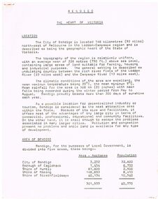
Document - BENDIGO - THE HEART OF VICTORIA
... , Minerals, Forests, Rail and Road, Sea and Air, Power and Water... Resources, Agriculture and Livestock, Minerals, Forests, Rail ...Typed article titled Bendigo, The Heart of Victoria. Items mentioned are Location, Area of Bendigo, The People, Work Force, Industrial Base, natural Resources, Agriculture and Livestock, Minerals, Forests, Rail and Road, Sea and Air, Power and Water, Electricity, Natural Gas, Water, Sewerage, Industrial Land, Services, Community Services and Facilities, Educational Facilities, Hospitals, Culture and Tourism and Media.document, bendigo - the heart of victoria, city of bendigo, borough of eaglehawk, shire of huntly, shire of marong, shire of strathfieldsaye, bendigo development committee, department of agriculture, department of state development decentralization and tourism, state electricity commission, gas & fuel corporation of victoria, state rivers & water supply commission, bendigo sewerage authority, the bendigo college of advanced education, home and hospital for the aged, home for the blind, northern school of nursing, art gallery, historical society, dudley house, sun loong, central deborah gold mine, the vintage talking trams and transport museum, bcv8, the bendigo advertiser, golden city gazette, 3bo, 3cv, mr a j kelly -
 Clunes Museum
Map, 1962
... SEALED ROADS, STATE FORESTS, PINE PLANTATIONS, FOREST AREAS.... FENTON. (2 COPIES) DETAILING SEALED ROADS, STATE FORESTS, PINE ....1 &.2 MAP OF BALLARAT SHIRE GROUP RURAL FIRE BRIGADES FIRE CONTROL MAP. COMPILED BY C. H. FENTON. (2 COPIES) DETAILING SEALED ROADS, STATE FORESTS, PINE PLANTATIONS, FOREST AREAS, RAILWAYS, BOUNDARIES, TOWNSHIP AREAS CEMETERIES, CREEKS, SWAMPS AND HOUSES.local history, document, maps, fire brigade -
 Whitehorse Historical Society Inc.
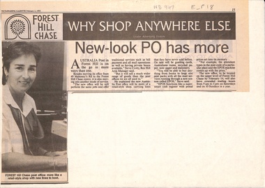
Newspaper - Article, New look post office has more, 2/02/1993
... its office from 49 Mahoneys Road to Forest Hill Chase Shopping... Post has moved its office from 49 Mahoneys Road to Forest Hill ...Article in Nunawading Gazette. Australia Post has moved its office from 49 Mahoneys Road to Forest Hill Chase Shopping Centre. It will be a new style post office selling cards and Australiana items etc. New system is called EPOS, the cash register has postal prices set in its memory.post offices, forest hill post office, australia post, forest hill chase -
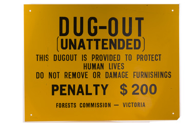 Forests Commission Retired Personnel Association (FCRPA)
Dugout sign, Post 1966
... . However, as the forest road network improved and gave all-weather.... However, as the forest road network improved and gave all-weather ...Considered in terms of both loss of property and loss of life, the Black Friday bushfires on 13 January 1939 were one of the worst disasters to have occurred in Australia and certainly the worst bushfire up to that time. The fires burnt 2 million hectares, 69 sawmills were destroyed, 71 people died, and several towns and sawmills were entirely obliterated. Among those killed were four men from the Commission The subsequent Royal Commission conducted by Judge Leonard Stretton has been described as one of the most significant inquiries in the history of Victorian public administration. Its recommendations led to sweeping changes. In addition to building dams and water points, the Stretton Royal Commission recommended expanding and controlling the use of bushfire dugouts at forest sawmills. Well-constructed dugouts had saved the lives of many sawmill workers and their families during the 1939 bushfires. But in some locations, they had proved fatal. Dugouts became mandatory for those few sawmills that remained in the forest after the 1939 fires. Many remote logging coupes and FCV roading camps also had dugouts. The local District Forester was required to make annual pre-season inspections of all dugouts on State forests and those within the Fire Protected Area (FPA). Some were built privately on private land. Most were primitive construction with a log or corrugated iron roof covered with earth. A hessian bag often hung at the entrance to keep the heat and smoke out. But they were dark and damp with snakes and other creepy crawlies often lurking inside. By 1940-41 there were 19 new dugouts constructed by the Commission and a further 128 by forest licensees. Ten years later there were 8 new Commission dugouts and 21 new ones built by other interests. By 1960-61 the rate of new builds was declining but the Commission still managed 103 dugouts while 127 were looked after by others. However, as the forest road network improved and gave all-weather access to modern two-wheel-drive vehicles the reliance on dugouts receded.Large metal sign that was positioned near forest dugoutsbushfire, forest signs, forests commission victoria (fcv) -
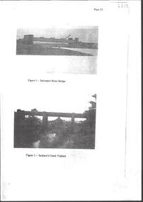 Bendigo Historical Society Inc.
Photograph - RAILWAYS COLLECTION: RAILWAY BRIDGES AND VIADUCTS
... Viaduct, Riddell Creek Bridge, Campbell's Creek Road bridge... , Jacksons Creek Viaduct, Riddell Creek Bridge, Campbell's Creek Road ...RAILWAYS COLLECTION -6 x Unbound Photocopied double sided pages giving information on the construction of the Bendigo Railway Line including Black and white photos of Railway Bridges and Viaducts - which show the Saltwater River bridge , Jacksons Creek Viaduct, Riddell Creek Bridge, Campbell's Creek Road bridge, Forest creek viaduct and Malmsbury Viaduct the photos are grainy in appearance.photograph, landscape -
 Bendigo Military Museum
Photograph - PHOTOGRAPH WW1, FRAMED, 1917
... -17 .10 Photo shows major roads, destroyed forests, trench..., 30c, 21 -10-17 .10 Photo shows major roads, destroyed forests ...label : Shell holes on battlefeild in France, taken from observation aircraft in 1917 dontaed by W Truel Milroy No VX113297 2/7th Battphoto of battle field in France 1917 mounted in frame, showing shell holes marked in top right corner is oriental army title of the air photo marked as = 4B 405 28-24 AC, 30c, 21 -10-17 .10 Photo shows major roads, destroyed forests, trench lines, and huge amount of bomb craters. frame - gold with timber trim. photography - photographs, frame accessories, military history, craters, battlefield -
 Bendigo Historical Society Inc.
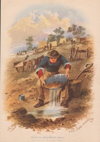
Painting - WES HARRY COLLECTION: S.T. GILL PRINTS, 1852 - 53
... , (b) Mt. Alexander Gold escort on road to Melbourne, (c) Road... on road to Melbourne, (c) Road from Forest Creek to Bendigo, (d ...A collection of nine prints of watercolours by S.T. Gill, depicting life on the goldfields in 1852 - 53. (a) Tin dish washing, (b) Mt. Alexander Gold escort on road to Melbourne, (c) Road from Forest Creek to Bendigo, (d) Diggers Licensing, Castlemaine Camp, (e) Eaglehawk Gully, Bendigo, (f) Cradling, (g) The license inspected, (h) Puddling, (i) Fryers Creek Nr. CastlemaineS. T. Gillpainting, watercolour, gold diggers, s.t. gill, life on the goldfields, diggers, mining -
 Bendigo Historical Society Inc.
Painting - ST GILL GOLDFIELD PRINTS
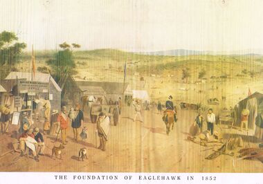
... To Allandale, Victor Cobb 1932, [2] Road from Forest Creek to Bendigo... drawing named 'The Road To Allandale, Victor Cobb 1932, [2] Road ...6 ST Gill prints titled, [1] 'The Foundation of Eaglehawk in 1852. On the reverse of (1) is a pencil drawing named 'The Road To Allandale, Victor Cobb 1932, [2] Road from Forest Creek to Bendigo. [3] Fryers Creek near Castlemaine. [4] Tin Dish Washing. [5] Diggers Licensing Castlemaine Camps. [6] Eaglehawk Gully Bendigo. Reverse stamped Bendigo Branch Royal Historical Society of Victoria, 1959.bendigo, gold mining, s t gill prints -
Bendigo Historical Society Inc.
Map - CAMPBELL COLLECTION: BENDIGO AND DISTRICT MAPS
... forest and crown land, highway main road access forest tracks..., reserved forest and crown land, highway main road access forest ...Map. Bendigo Whipstick Forest Park, 1:75,000, reserved forest and crown land, highway main road access forest tracks. New Moon Mine, Elliot Dam, Nuggety Dam, Rogers Tree, Old Tom Mine, Blow Holes, Skylark Dam, Monument Rock, Hartland Eucalyptus Still and Dam, Hartland Eucalyptus Farm, Millwood Dam, Sandner Eucalyptus Still Site, Various unmarked dams. (number 391 in map cupboard 1)map, bendigo, country lands -
Bendigo Historical Society Inc.
Map - PETER ELLIS COLLECTION: MAP OF WHIPSTICK
... places. Bitumen roads, gravel, forest tracks, Mallee Areas... places. Bitumen roads, gravel, forest tracks, Mallee Areas ...Two maps of the Whipstick - Sheet A and Sheet B. Sheet A shows the Whipstick in relation to Bendigo and some surrounding places. Bitumen roads, gravel, forest tracks, Mallee Areas, Flagstaff Hill, fenced in reservations and reservoirs are marked. Also a circle and part circles of 5, 10, 15 and 20 mile radius are marked. North & South are marked. Sheet B is an enlarged area of the Whipstick Scrub area. North and South is marked. There are a number of letters written over both maps.map, bendigo, whipstick, peter ellis collection, the whipstick, flagstaff hill -
 Kew Historical Society Inc
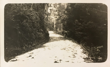
Photograph - Country road, c.1927
... a snapshot of a winding dirt track/road, thickly forested with native... a snapshot of a winding dirt track/road, thickly forested with native ...Henry Beater Christian (1886-1962) , was a descendant of one of the earliest settler families in Kew. Employed at the Kew Asylum as a 'public servant', he was a skilled amateur photographer, photographing numerous scenes in Kew and on his travels around Victoria. The majority of his photographs date from 1916 to 1929. His finest photographs are housed in two photograph albums. Digital copy of a photograph from page 25 of the 47-page photograph album containing 261 gelatinous silver images, loaned by Diane Washfold with permission given to digitise and hold a copy in our collection. John Chapman has written in 'Bushwalking Clubs - A Brief History', about the establishment in Victoria of the first bushwalking club in 1888, and the popularisation of bushwalking during the interwar period. Henry Christian's 'walks' appear to have been undertaken solely or with a companion/s. Here the photographer takes a snapshot of a winding dirt track/road, thickly forested with native vegetation. The photograph is emblematic of the journey. Inscription on page illegiblehenry beater christian (1886-1962), landscape photography, christian-washfold collection, photograph albums, bushwalking -
 Bendigo Historical Society Inc.
Slide - DIGGERS & MINING. THE DIGGING - THE DIGGERS, c1850s
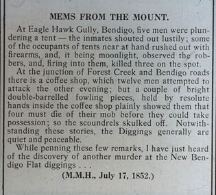
... into them, killed three on the spot. At the junction of Forest Creek... on the spot. At the junction of Forest Creek and Bendigo roads ...Diggers & Mining. The Digging - The Diggers. Slide; An article titled 'Mems From The Mount' At Eagle Hawk Gully, Bendigo, five men were plundering a tent - the inmates shouted out lustily; some of the occupants of tent near at hand rushed out with firearms, and it being moonlight, observed the robbers, and, firing into them, killed three on the spot. At the junction of Forest Creek and Bendigo roads there is a coffee shop, which twelve men attempted to attack the other evening; but a couple of bright double-barrelled fowling pieces, held by the resolute hands inside the coffee shop plainly showed them that possession; so the scoundrels skulled of. Not with-standing these stories, the Diggers generally are quiet and peaceable. While penning these few remarks, I have just heard of the discovery of another murder at the New Bendigo Flat Diggings. (M.M.H., July 17, 1852) Markings: -- 994.LIF:6. Used as a teaching aid.hanimounteducation, tertiary, goldfields -
 Orbost & District Historical Society
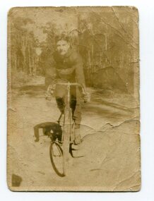
black and white photograph, 1920 - 1930
... bike. It is on an unsealed road in a forest. ... of a young man on a racing bike. It is on an unsealed road ...By 1905 there was an Orbost Bicycle Club. E. Donchi was a member and was a successful competitor around 1927. It is likely that the Orbost Cycling Club disbanded during WWI, and evidence from the Snowy River Mail is that it reformed again in 1945. There is no doubt that bikes were a dominant form of personal transport until the 1960s when cars ownership became more common, although children still rode to school. As far as theOrbost Cycling Club was concerned, the golden years were from 1945 to 1950. (information Newsletter August 2018 - Geoff & Lee Stevenson)This item is associated with a popular recreational activity in early Orbost. The period between the First World War and the 1950s was the heyday of cycling. After 1900 the efficient mass production of standardized safe bicycles, as well as the wider availability of second-hand bicycles, caused rapidly dropping prices and it was therefore easier for people to purchase a bicycle not only for utilitarian use but for racing. A small black / white photograph of a young man on a racing bike. It is on an unsealed road in a forest. on back - "E. Donchi, Cyclist, Orbost"donchi cycling-orbost recreation -
 Ballan Shire Historical Society
Map - Map. Bungal, Department of Lands and Survey, Bungal, County of Grant, 09/09/1926
A map of Bungal in the 1920's showing the allotments, and the size, with the names of the residents. It shows the roads and the Western and Eastern Moorarbool River, and the Whipstick State Forest.Cream coloured map of Bungal in the County of Grant, bounded by the the East Moorarbool River on the East, and the State Forest on the South. It is marked with the scale of chains and the number L.358. Lithographed at the Department of Lands and Survey. Melbourne by W. J. Butson on 9.9.1926. It shows the land allotments with names of owners.Coloured pen marks and circled numbers on various areas. Price 2 shillings marked on bottom right hand edge.bungal, kerrit bareet, egerton, lal lal, borhoneyghurk, bungeeltap, ballark, yaloak, gorong, moorarbool west -
 Ballan Shire Historical Society
Map - Map. Shire of Ballan, Shire of Ballan
This is a fairly comprehensive map of the former Shire of Ballan which is now amalgamated into the Shire of Moorabool.A black and white map of the Shire of Ballan showing major roads, rivers, towns, settlements, State parks and forests and land subdivisions. It appears to be a copy of the original as no dates or maker or printer appear on the map. There is a scale of 2 miles to 1 inch.gordon, ballan, bungal, kerrit bareet, borhoneyghurk, bungeeltap, ballark, yaloak, gorong, beremboke, wallace, ingliston, hunterston, millbrook, bradshaw, myrniong, blackwood, moorarbool, greendale, bayup, trentham, bullarto, korweinguboora, glenlyon, bolwarra -
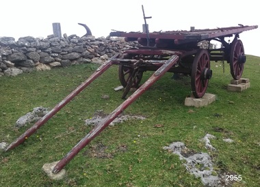 Flagstaff Hill Maritime Museum and Village
Wagon, circa 1850s
Bostock & Manifold were all from pioneering families in the Western District of Victoria almost from the time of settlement. Family history: The Bostock family were prominent in Warrnambool from the 1850s to the 1880s. Patriarch Robert Bostock had in 1813 been transported to Sydney from Sierra Leone for having 'felonious traded in slaves' and sentenced to 14 years transportation. He moved to Tasmania in 1821 where he died in 1847. A number of his children came to Port Phillip. Edward Robert Bostock held the Jellabad run from 1849 to 1853. George Bostock (1826-1858) was a Warrnambool Shire Councillor in 1856. Thomas Edward Bostock (1828-1874) was a Shire Councillor in the late 1860s. Augustus Bostock (1833-1920) lived in Warrnambool. Augustus Bostock was the 9th child of Robert and Rachael Bostock of Vaucluse Epping Forest, Van Diemen's Land. He was only 4 years old when his mother died. He was inspired by his father to seek his fortune in the Western District of Victoria. He arrived around 1850. He married Margaret Aitkin in July 1865. Augustus owned several properties in the district and leased others. He sat on the court of Warrnambool, Mortlake or Hexham as required. He resided at Marramook in Hawkesdale and later moved to Vaucluse in Hopetoun Road Warrnambool, where he died in 1920 at the age of 87. The Wagon is significant locally and state wide for its association with Augustus Bostock who was involved in many aspects of life in the Western District of Victoria, racing, cricket, and social activities to name a few. Bostock & Manifold were all from pioneering families in the Western District of Victoria almost from the time of settlement. The wagon is significant for its historical and economic association with the local Warrnambool business of Manifold & Bostock. These men had leased and owned vast tracts of land and operated businesses around the district together at various times often associated with the farming industry. One example is the Manifold & Bostock store and flour mill from which the wagon dray is believed to have been associated with for the delivery of goods. Their flour mill began operation in 1850 in 7-17 Stanley St South Warrnambool and was known as “Jetty Mills” Manifold and Bostock in 1858 purchased the Mill from John and G Elliot (brothers) with half an acre of ground and a cottage for £1600. It appears addresses of the company changed over the years as the town grew. These are listed in “Jones, Lewis & Peggy flour mills of Victoria” showing the company operating from, Fairy Street and later at the Merri River near the cutting, known as Banyan and Merri Streets. The company ceased trading in 1870. The Wagon Dray is also an example of agricultural freight and general transportation during the 1800 and 1900 century.A four-wheeled wooden horse-drawn wagon with flat top described as a Wagon Dray in historical writings. Painted brown and black. The wagon has rear brakes, wooden, operated from a metal handle at the front of the Wagon. Front wheels are attached to a turnstile to allow easy turning of the wagon. This flat-topped, horse driven, four-wheeled Wagon was used for cartage by the business of Manifold & Bostock, Warrnambool. The original sign writing of the wagon is obscured or painted over. There is a feint mark of lettering to the sides and back edges of the cart Manifold & Bostock. "Manifold and Bostock" very feintflagstaff hill, warrnambool, shipwrecked-coast, flagstaff-hill, flagstaff-hill-maritime-museum, maritime-museum, flagstaff-hill-maritime-village, cartage, manifold and bostock of warrnambool, manifold family of western victoria, bostock family of western victoria, four wheeled wagon, wagon, horse drawn wagon, farm wagon, aitkin, aitkin bostock manifold, dray, aitkin family, cart, aitken, flour mill -
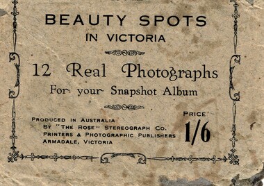 Phillip Island and District Historical Society Inc.
Postcard, Beauty spots in Victoria
... . Lovers Walk - Cowes, 10. Forest Cave, 11. The road to back beach.... Forest Cave, 11. The road to back beach, 12. The beach & pier ...Tourist photographs of Phillip IslandHistoricalSmall black and white photos of scenes of Phillip Island including the jetty, beach, Nobbies and ferries. Enclosed in a beige paper envelope.Beauty spots in Victoria. 12 Real Photographs for your Snapshot Album. Produced in Australia by The Rose Stereograph Co. Price 1/6 1. The Pier, Cowes, 2. Front beach, Cowes, 3. Alvina & Genista at pier, $. Koala in tree, 5. beach near Nobbies, 6. The Nobbies, 7. The Pinnacles, 8. Looking out at Forest caves, 9. Lovers Walk - Cowes, 10. Forest Cave, 11. The road to back beach, 12. The beach & pier, Cowes.the nobbies, ferries, cowes jetty, forrest caves, phillip island, black & white postcard copy, photographs -
 Warrnambool and District Historical Society Inc.
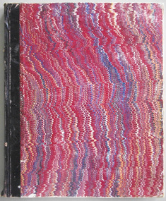
Journal - Diary, Diary of Augustus Bostock 1862-1870, Circa 1860
Augustus Bostock was the 9th child of Robert & Rachael Bostock of Vaucluse Epping Forest, Van Diemen’s Land. He was only 4 years old when his mother died. He was inspired by his father to seek his fortune in the Western District of Victoria. He arrived around 1850. He married Margaret Aitkin in July 1865. Augustus owned several properties in the district and leased others. He sat on the court of Warrnambool, Mortlake or Hexham as required. He resided at Marramook in Hawkesdale and later moved to Vaucluse in Hopetoun Road Warrnambool, where he died in 1920 at the age of 87. He was involved in many aspects of life in the Western District, racing, cricket, and social activities to name a few. This diary shows the daily entries over a long period of time with activities ranging from fencing, visiting neighbours and weather details. It mentions many local people and many properties he visited. Augustus Bostock along with a number of his brothers was one of the earliest pioneers in the Western District of Victoria. This diary sheds considerable light onto the life of Augustus and people of his era. There is a wealth of information on a range of topics relating to early life in Warrnambool and district.Physical Description: Dark grey stippled cloth hard cover with tan leather corners and spine. Brown and gold coloured paper inside front and back covers. Pages written in black pen.Title page has A Bostock Grasmere. Diary from June 10th 1862.warrnambool, bostock, augustus bostock, bostock diary, augustus bostock 1862 -
 Warrnambool and District Historical Society Inc.
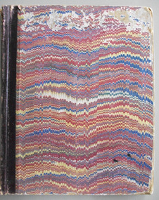
Journal - Diary, Diary of Augustus Bostock 1871-1873, Circa 1871
Augustus Bostock was the 9th child of Robert & Rachael Bostock of Vaucluse Epping Forest, Van Diemen’s Land. He was only 4 years old when his mother died. He was inspired by his father to seek his fortune in the Western District of Victoria. He arrived around 1850. He married Margaret Aitkin in July 1865. Augustus owned several properties in the district and leased others. He sat on the court of Warrnambool, Mortlake or Hexham as required. He resided at Marramook in Hawkesdale and later moved to Vaucluse in Hopetoun Road Warrnambool, where he died in 1918 at the age of 87. He was involved in many aspects of life in the Western District, racing, cricket, and social activities to name a few. This diary shows the daily entries over a long period of time with activities ranging from fencing, visiting neighbours and weather details. It mentions many local people and many properties he visited. Augustus Bostock along with a number of his brothers was one of the earliest pioneers in the Western District of Victoria. This diary sheds considerable light onto the life of Augustus and people of his era. There is a wealth of information on a range of topics relating to early life in Warrnambool and district.Brown, blue, yellow and white wavy pattern cover with black binding. Edges of pages have a multi coloured pattern. Entries are handwritten in black ink.G. Bostock, Coomite Jan 1st 1871 warrnambool, augustus bostock, marramook hawkesdale, bostock brothers, pioneers warrnambool -
 Warrnambool and District Historical Society Inc.
Journal - Diary, Diary of Augustus Bostock 1873-1876, Circa 1873
Augustus Bostock was the 9th child of Robert & Rachael Bostock of Vaucluse Epping Forest, Van Diemen’s Land. He was only 4 years old when his mother died. He was inspired by his father to seek his fortune in the Western District of Victoria. He arrived around 1850. He married Margaret Aitkin in July 1865. Augustus owned several properties in the district and leased others. He sat on the court of Warrnambool, Mortlake or Hexham as required. He resided at Marramook in Hawkesdale and later moved to Vaucluse in Hopetoun Road Warrnambool, where he died in 1920 at the age of 87. He was involved in many aspects of life in the Western District, racing, cricket, and social activities to name a few. This diary shows the daily entries over a long period of time with activities ranging from fencing, visiting neighbours and weather details. It mentions many local people and many properties he visited. Augustus Bostock along with a number of his brothers was one of the earliest pioneers in the Western District of Victoria. This diary sheds considerable light onto the life of Augustus and people of his era. There is a wealth of information on a range of topics relating to early life in Warrnambool and district.Maroon, blue, white and yellow patterned cardboard cover with black binding on spine. Pages written in black pen apart from entries for August and September which are written in blue ink. Coomete 16th June 1873. C/N 2/- inside front cover.bostock, augustus bostock, vaucluse warrnambool, warrnambool -
 Warrnambool and District Historical Society Inc.
Journal - Diary, Diary of Augustus Bostock 1877-1881, Circa 1877
Augustus Bostock was the 9th child of Robert & Rachael Bostock of Vaucluse Epping Forest, Van Diemen’s Land. He was only 4 years old when his mother died. He was inspired by his father to seek his fortune in the Western District of Victoria. He arrived around 1850. He married Margaret Aitkin in July 1865. Augustus owned several properties in the district and leased others. He sat on the court of Warrnambool, Mortlake or Hexham as required. He resided at Marramook in Hawkesdale and later moved to Vaucluse in Hopetoun Road Warrnambool, where he died in 1920 at the age of 87. He was involved in many aspects of life in the Western District, racing, cricket, and social activities to name a few. This diary shows the daily entries over a long period of time with activities ranging from fencing, visiting neighbours and weather details. It mentions many local people and many properties he visited. Augustus Bostock along with a number of his brothers was one of the earliest pioneers in the Western District of Victoria. This diary sheds considerable light onto the life of Augustus and people of his era. There is a wealth of information on a range of topics relating to early life in Warrnambool and district.Blue, tan, yellow and white patterned cover with maroon binding. Fawn pages inside front and back covers. Pages are all handwritten. Sticker inside front cover: J Hider Opposite the Post Office Warrnambool.1/9. A Bostock Coomite Diary for 1877 warrnambool, augustus bostock, gussy bostock, marramook hawkesdale, bostock brothers -
 Warrnambool and District Historical Society Inc.
Journal - Diary, Diary of Augustus Bostock 1881-1890, Circa 1881
Augustus Bostock was the 9th child of Robert & Rachael Bostock of Vaucluse Epping Forest, Van Diemen’s Land. He was only 4 years old when his mother died. He was inspired by his father to seek his fortune in the Western District of Victoria. He arrived around 1850. He married Margaret Aitkin in July 1865. Augustus owned several properties in the district and leased others. He sat on the court of Warrnambool, Mortlake or Hexham as required. He resided at Marramook in Hawkesdale and later moved to Vaucluse in Hopetoun Road Warrnambool, where he died in 1920 at the age of 87. He was involved in many aspects of life in the Western District, racing, cricket, and social activities to name a few. This diary shows the daily entries over a long period of time with activities ranging from fencing, visiting neighbours and weather details. It mentions many local people and many properties he visited. Augustus Bostock along with a number of his brothers was one of the earliest pioneers in the Western District of Victoria. This diary sheds considerable light onto the life of Augustus and people of his era. There is a wealth of information on a range of topics relating to early life in Warrnambool and district.Brown stippled cloth cover with brown corners and spine in leather. Purple and green patterned paper inside front and back covers. Pages are handwritten in black ink. Sticker inside front cover: J Hider Opposite the Post Office Warrnambool. M/R 6/- Augustus Bostock Coomite Diary 1881 warrnambool, augustus bostock, gussy bostock, vaucluse warrnambool, bostock brothers -
 Warrnambool and District Historical Society Inc.
Journal - Diary, Diary of Augustus Bostock 1890, Circa 1890
Augustus Bostock was the 9th child of Robert & Rachael Bostock of Vaucluse Epping Forest, Van Diemen’s Land. He was only 4 years old when his mother died. He was inspired by his father to seek his fortune in the Western District of Victoria. He arrived around 1850. He married Margaret Aitkin in July 1865. Augustus owned several properties in the district and leased others. He sat on the court of Warrnambool, Mortlake or Hexham as required. He resided at Marramook in Hawkesdale and later moved to Vaucluse in Hopetoun Road Warrnambool, where he died in 1920 at the age of 87. He was involved in many aspects of life in the Western District, racing, cricket, and social activities to name a few. This diary shows the daily entries over a long period of time with activities ranging from fencing, visiting neighbours and weather details. It mentions many local people and many properties he visited. Augustus Bostock along with a number of his brothers was one of the earliest pioneers in the Western District of Victoria. This diary sheds considerable light onto the life of Augustus and people of his era. There is a wealth of information on a range of topics relating to early life in Warrnambool and district.Blue cloth, water wave cover with maroon binding.Maroon, blue and white patterned pages inside front and back covers. Pages are all handwritten. Coomete 1890.diary of augustus bostock 1890, warrnambool -
 Warrnambool and District Historical Society Inc.
Journal - Diary, Diary of Augustus Bostock 1896-1904, Circa 1896
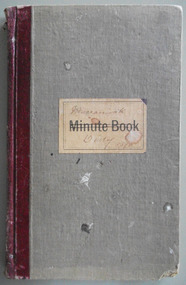
Augustus Bostock was the 9th child of Robert & Rachael Bostock of Vaucluse Epping Forest, Van Diemen’s Land. He was only 4 years old when his mother died. He was inspired by his father to seek his fortune in the Western District of Victoria. He arrived around 1850. He married Margaret Aitkin in July 1865. Augustus owned several properties in the district and leased others. He sat on the court of Warrnambool, Mortlake or Hexham as required. He resided at Marramook in Hawkesdale and later moved to Vaucluse in Hopetoun Road Warrnambool, where he died in 1920 at the age of 87. He was involved in many aspects of life in the Western District, racing, cricket, and social activities to name a few. This diary shows the daily entries over a long period of time with activities ranging from fencing, visiting neighbours and weather details. It mentions many local people and many properties he visited. Augustus Bostock along with a number of his brothers was one of the earliest pioneers in the Western District of Victoria. This diary sheds considerable light onto the life of Augustus and people of his era. There is a wealth of information on a range of topics relating to early life in Warrnambool and district.Grey cloth cover over card with maroon leather binding. Blue pages inside front and back covers. Pages are all handwritten with dates in margin. Edges of pages orange blue and yellow. Label on front cover has Minute Book printed on cream label. Marramook Diary 1896 hand written in pen. 286 pages.Marramook Sept 15th 1896 Augustus Bostock. diary of augustus bostock 1896-1904, warrnambool -
 Warrnambool and District Historical Society Inc.
Journal - Diary, Diary of Augustus Bostock 1904-1907, Circa 1904
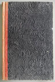
Augustus Bostock was the 9th child of Robert & Rachael Bostock of Vaucluse Epping Forest, Van Diemen’s Land. He was only 4 years old when his mother died. He was inspired by his father to seek his fortune in the Western District of Victoria. He arrived around 1850. He married Margaret Aitkin in July 1865. Augustus owned several properties in the district and leased others. He sat on the court of Warrnambool, Mortlake or Hexham as required. He resided at Marramook in Hawkesdale and later moved to Vaucluse in Hopetoun Road Warrnambool, where he died in 1920 at the age of 87. He was involved in many aspects of life in the Western District, racing, cricket, and social activities to name a few. This diary shows the daily entries over a long period of time with activities ranging from fencing, visiting neighbours and weather details. It mentions many local people and many properties he visited. Augustus Bostock along with a number of his brothers was one of the earliest pioneers in the Western District of Victoria. This diary sheds considerable light onto the life of Augustus and people of his era. There is a wealth of information on a range of topics relating to early life in Warrnambool and district.Cardboard cover, water- waved patterned in black and grey with orange cloth binding. Pages are all handwritten with dates in margin. Augustus Bostock Diary for 1904.diary of augustus bostock 1904-1907, warrnambool -
 Warrnambool and District Historical Society Inc.
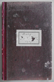
Journal - Diary, Diary of Augustus Bostock 1909-1913, Circa 1909
Augustus Bostock was the 9th child of Robert & Rachael Bostock of Vaucluse Epping Forest, Van Diemen’s Land. He was only 4 years old when his mother died. He was inspired by his father to seek his fortune in the Western District of Victoria. He arrived around 1850. He married Margaret Aitkin in July 1865. Augustus owned several properties in the district and leased others. He sat on the court of Warrnambool, Mortlake or Hexham as required. He resided at Marramook in Hawkesdale and later moved to Vaucluse in Hopetoun Road Warrnambool, where he died in 1920 at the age of 87. He was involved in many aspects of life in the Western District, racing, cricket, and social activities to name a few. This diary shows the daily entries over a long period of time with activities ranging from fencing, visiting neighbours and weather details. It mentions many local people and many properties he visited. Augustus Bostock along with a number of his brothers was one of the earliest pioneers in the Western District of Victoria. This diary sheds considerable light onto the life of Augustus and people of his era. There is a wealth of information on a range of topics relating to early life in Warrnambool and district.Maroon coloured cloth bound card cover, with grey paper label on front. Spine binding is maroon leather. Pages inside front and back covers are blue. Pages numbered to 186 and are all handwritten in black pen with days written in margins.Diary 1909 handwritten on label on front cover. A Bostock Oct 1909 inside front cover.augustus bostock, warrnambool, bostock brothers, bostock diary