Showing 272 items matching "houses - cowes"
-
 Bendigo Historical Society Inc.
Photograph - Historical Society Field Trip to the Springs at Sedgwick, Abt 2009
The Phil Wilkin Collection contains a series of 11 Items. The related items can be found by clicking on the reference link below. The following history of the Young family and their descendants who lived at the Springs is provided by Phil Wilkin. His Great Grandparents were Frances Young and August Wirth. Phil has also provided notes on the Wilkin Family and some history of the gold mining in Sedgwick. Frances Young's parents Joseph and Margaret Young owned the property called "The Old Place, Preston Vale or Wellington Flat" at Sedgwick near the Springs. Joseph Young owned and Managed the Standard Brewery which was located at Campbells Creek during the late 1800’s early 1900’s. Joseph and Margaret are buried in the Harcourt cemetery. In 1880 August Wirth lived at Mosquito Creek (Lake Eppalock, Victoria) when he married Frances Young. In 1902 they moved to part of Joseph Young's property. They milked cows and sold cattle for a living. One of their children Charles Wirth (Phil Wilkin's Grandfather) bought the land in 1935 after his parents had died. Charles Wirth was a councillor and also was president of the Shire of Strathfieldsaye. The "Old Place" was part of the property owned by members of the family. The old house at the Springs was burnt out by bushfire in January 1944 and much of the stonework was later vandalized by campers. The original Coliban Water Works were designed in 1863 by the Irish engineer Joseph Brady. The system included 70 kilometres of open water channels, aqueducts, syphons and tunnels to carry water (by gravity) from the Coliban River at Malmsbury, north to Castlemaine and Bendigo. Sedgwick is a locality in Central Victoria, Australia. It is located in the City of Greater Bendigo. Facilities include a public hall that opened in 1958 and CFA Rural fire station. It was named Upper Emu Creek until 1901 when it was renamed as Sedgwick after British geologist Adam Sedgwick.Twenty six photos taken on a field trip by the Bendigo Historical Society to "The Springs" on the main Coliban water channel from Malmsbury to the Sandhurst Reservoir in Bendigo. The water race descends through a concrete chute, and continues sharply around the contour of the hills. Once it descended into a syphon across the gully. The are 182 photos in this series and can be found at 8683.1 to 8683.11. The series also includes photos of the surrounding farming land and the remains of an old house. There are also some notes on the pioneers of the district.history, bendigo, coliban water, joseph brady, irrigation, the springs, sedgwick -
 Bendigo Historical Society Inc.
Photograph - Historical Society Field Trip to the Springs at Sedgwick, Abt 2009
The Phil Wilkin Collection contains a series of 11 Items. The related items can be found by clicking on the reference link below. The following history of the Young family and their descendants who lived at the Springs is provided by Phil Wilkin. His Great Grandparents were Frances Young and August Wirth. Phil has also provided notes on the Wilkin Family and some history of the gold mining in Sedgwick. Frances Young's parents Joseph and Margaret Young owned the property called "The Old Place, Preston Vale or Wellington Flat" at Sedgwick near the Springs. Joseph Young owned and Managed the Standard Brewery which was located at Campbells Creek during the late 1800’s early 1900’s. Joseph and Margaret are buried in the Harcourt cemetery. In 1880 August Wirth lived at Mosquito Creek (Lake Eppalock, Victoria) when he married Frances Young. In 1902 they moved to part of Joseph Young's property. They milked cows and sold cattle for a living. One of their children Charles Wirth (Phil Wilkin's Grandfather) bought the land in 1935 after his parents had died. Charles Wirth was a councillor and also was president of the Shire of Strathfieldsaye. The "Old Place" was part of the property owned by members of the family. The old house at the Springs was burnt out by bushfire in January 1944 and much of the stonework was later vandalized by campers. The original Coliban Water Works were designed in 1863 by the Irish engineer Joseph Brady. The system included 70 kilometres of open water channels, aqueducts, syphons and tunnels to carry water (by gravity) from the Coliban River at Malmsbury, north to Castlemaine and Bendigo. Sedgwick is a locality in Central Victoria, Australia. It is located in the City of Greater Bendigo. Facilities include a public hall that opened in 1958 and CFA Rural fire station. It was named Upper Emu Creek until 1901 when it was renamed as Sedgwick after British geologist Adam Sedgwick.Twenty five photos taken on a field trip by the Bendigo Historical Society to "The Springs" on the main Coliban water channel from Malmsbury to the Sandhurst Reservoir in Bendigo. The water race descends through a concrete chute, and continues sharply around the contour of the hills. Once it descended into a syphon across the gully. The are 182 photos in this series and can be found at 8683.1 to 8683.11. The series also includes photos of the surrounding farming land and the remains of an old house. There are also some notes on the pioneers of the district.history, bendigo, coliban water, joseph brady, irrigation, the springs, sedgwick -
 Bendigo Historical Society Inc.
Photograph - The Young and Wirth Families at Preston Vale, near the Springs Sedgwick, 1880s-1900s
The Phil Wilkin Collection contains a series of 11 Items. The related items can be found by clicking on the reference link below. The following history of the Young family and their descendants who lived at the Springs is provided by Phil Wilkin. His Great Grandparents were Frances Young and August Wirth. Phil has also provided notes on the Wilkin Family and some history of the gold mining in Sedgwick. Frances Young's parents Joseph and Margaret Young owned the property called "The Old Place, Preston Vale or Wellington Flat" at Sedgwick near the Springs. Joseph Young owned and Managed the Standard Brewery which was located at Campbells Creek during the late 1800’s early 1900’s. Joseph and Margaret are buried in the Harcourt cemetery. In 1880 August Wirth lived at Mosquito Creek (Lake Eppalock, Victoria) when he married Frances Young. In 1902 they moved to part of Joseph Young's property. They milked cows and sold cattle for a living. One of their children Charles Wirth (Phil Wilkin's Grandfather) bought the land in 1935 after his parents had died. Charles Wirth was a councillor and also was president of the Shire of Strathfieldsaye. The "Old Place" was part of the property owned by members of the family. The old house at the Springs was burnt out by bushfire in January 1944 and much of the stonework was later vandalized by campers. The original Coliban Water Works were designed in 1863 by the Irish engineer Joseph Brady. The system included 70 kilometres of open water channels, aqueducts, syphons and tunnels to carry water (by gravity) from the Coliban River at Malmsbury, north to Castlemaine and Bendigo. Sedgwick is a locality in Central Victoria, Australia. It is located in the City of Greater Bendigo. Facilities include a public hall that opened in 1958 and CFA Rural fire station. It was named Upper Emu Creek until 1901 when it was renamed as Sedgwick after British geologist Adam Sedgwick.Thirty Four Photos of Joseph Young's property near "The Springs" on the main Coliban water channel from Malmsbury to the Sandhurst Reservoir in Bendigo. This item contains family history of Joeph's descendant Charles Wirth, who was a councillor for the Shire of Strathfieldsaye. The water race descends through a concrete chute, and continues sharply around the contour of the hills. Once it descended into a syphon across the gully. The are 182 photos in this series and can be found at 8683.1 to 8683.11. The series also includes photos of the surrounding farming land and the remains of an old house. There are also some notes on the pioneers of the district.history, bendigo, coliban water, joseph brady, irrigation, the springs, sedgwick, charles wirth, preston vale, joseph and margaret young, standard brewery campbells creek harcourt, phil wilkin collection -
 Bendigo Historical Society Inc.
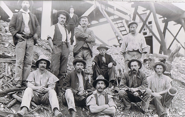
Photograph - The Sedgwick Gold Mine, abt 1909
The Phil Wilkin Collection contains a series of 11 Items. The related items can be found by clicking on the reference link below. The following history of the Young family and their descendants who lived at the Springs is provided by Phil Wilkin. His Great Grandparents were Frances Young and August Wirth. Phil has also provided notes on the Wilkin Family and some history of the gold mining in Sedgwick. Frances Young's parents Joseph and Margaret Young owned the property called "The Old Place, Preston Vale or Wellington Flat" at Sedgwick near the Springs. Joseph Young owned and Managed the Standard Brewery which was located at Campbells Creek during the slate 1800’s early 1900’s. Joseph and Margaret are buried in the Harcourt cemetery. In 1880 August Wirth lived at Mosquito Creek (Lake Eppalock, Victoria) when he married Frances Young. In 1902 they moved to part of Joseph Young's property. They milked cows and sold cattle for a living. One of their children Charles Wirth (Phil Wilkin's Grandfather) bought the land in 1935 after his parents had died. Charles Wirth was a councillor and also was president of the Shire of Strathfieldsaye. The "Old Place" was part of the property owned by members of the family. The old house at the Springs was burnt out by bushfire in January 1944 and much of the stonework was later vandalized by campers. The original Coliban Water Works were designed in 1863 by the Irish engineer Joseph Brady. The system included 70 kilometres of open water channels, aqueducts, syphons and tunnels to carry water (by gravity) from the Coliban River at Malmsbury, north to Castlemaine and Bendigo. Sedgwick is a locality in Central Victoria, Australia. It is located in the City of Greater Bendigo. Facilities include a public hall that opened in 1958 and CFA Rural fire station. It was named Upper Emu Creek until 1901 when it was renamed as Sedgwick after British geologist Adam Sedgwick.Four photos of the miners and information on the Sedgwick Gold Mine. There are 182 photos in this series and can be found at 8683.1 to 8683.11. The series also includes photos of the surrounding farming land and the remains of an old house. There are also some notes on the pioneers of the district.history, bendigo, coliban water, joseph brady, irrigation, the springs, sedgwick, phil wilkin collection, sedgwick gold mine -
 Bendigo Historical Society Inc.
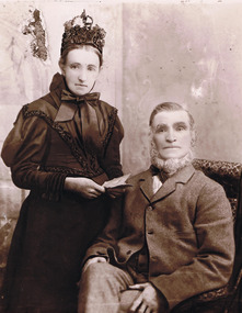
Photograph - Joseph and Margaret Young from Preston Vale (near The Springs) Sedgwick, 1800s-1900s
The Phil Wilkin Collection contains a series of 11 Items. The related items can be found by clicking on the reference link below. The following history of the Young family and their descendants who lived at the Springs is provided by Phil Wilkin. His Great Grandparents were Frances Young and August Wirth. Phil has also provided notes on the Wilkin Family and some history of the gold mining in Sedgwick. Frances Young's parents Joseph and Margaret Young owned the property called "The Old Place, Preston Vale or Wellington Flat" at Sedgwick near the Springs. Joseph Young owned and Managed the Standard Brewery which was located at Campbells Creek during the late 1800’s early 1900’s. Joseph and Margaret are buried in the Harcourt cemetery. In 1880 August Wirth lived at Mosquito Creek (Lake Eppalock, Victoria) when he married Frances Young. In 1902 they moved to part of Joseph Young's property. They milked cows and sold cattle for a living. One of their children Charles Wirth (Phil Wilkin's Grandfather) bought the land in 1935 after his parents had died. Charles Wirth was a councillor and also was president of the Shire of Strathfieldsaye. The "Old Place" was part of the property owned by members of the family. The old house at the Springs was burnt out by bushfire in January 1944 and much of the stonework was later vandalized by campers. The original Coliban Water Works were designed in 1863 by the Irish engineer Joseph Brady. The system included 70 kilometres of open water channels, aqueducts, syphons and tunnels to carry water (by gravity) from the Coliban River at Malmsbury, north to Castlemaine and Bendigo. Sedgwick is a locality in Central Victoria, Australia. It is located in the City of Greater Bendigo. Facilities include a public hall that opened in 1958 and CFA Rural fire station. It was named Upper Emu Creek until 1901 when it was renamed as Sedgwick after British geologist Adam Sedgwick.12 photos and historical document of Joseph and Margaret Young. There are 182 photos in this series and can be found at 8683.1 to 8683.11. The series also includes photos of the surrounding farming land and the remains of an old house. There are also some notes on the pioneers of the district.history, bendigo, coliban water, joseph brady, irrigation, the springs, sedgwick, phil wilkin collection, standard brewery campbells creek, joeseph and margaret young -
 Bendigo Historical Society Inc.
Photograph - The Wilkin Family of Sedgwick, 1800s-1900s
The Phil Wilkin Collection contains a series of 11 Items. The related items can be found by clicking on the reference link below. The following history of the Young family and their descendants who lived at the Springs is provided by Phil Wilkin. His Great Grandparents were Frances Young and August Wirth. Phil has also provided notes on the Wilkin Family and some history of the gold mining in Sedgwick. Frances Young's parents Joseph and Margaret Young owned the property called "The Old Place, Preston Vale or Wellington Flat" at Sedgwick near the Springs. Joseph Young owned and Managed the Standard Brewery which was located at Campbells Creek during the late 1800’s early 1900’s. Joseph and Margaret are buried in the Harcourt cemetery. In 1880 August Wirth lived at Mosquito Creek (Lake Eppalock, Victoria) when he married Frances Young. In 1902 they moved to part of Joseph Young's property. They milked cows and sold cattle for a living. One of their children Charles Wirth (Phil Wilkin's Grandfather) bought the land in 1935 after his parents had died. Charles Wirth was a councillor and also was president of the Shire of Strathfieldsaye. The "Old Place" was part of the property owned by members of the family. The old house at the Springs was burnt out by bushfire in January 1944 and much of the stonework was later vandalized by campers. The original Coliban Water Works were designed in 1863 by the Irish engineer Joseph Brady. The system included 70 kilometres of open water channels, aqueducts, syphons and tunnels to carry water (by gravity) from the Coliban River at Malmsbury, north to Castlemaine and Bendigo. Sedgwick is a locality in Central Victoria, Australia. It is located in the City of Greater Bendigo. Facilities include a public hall that opened in 1958 and CFA Rural fire station. It was named Upper Emu Creek until 1901 when it was renamed as Sedgwick after British geologist Adam Sedgwick.17 photos and historical document of the Wilkin Family associated with the Springs near Sedgwick. There are 182 photos in this series and can be found at 8683.1 to 8683.11. The series also includes photos of the surrounding farming land and the remains of an old house. There are also some notes on the pioneers of the district.history, bendigo, coliban water, joseph brady, irrigation, the springs, sedgwick, phil wilkin collection, standard brewery campbells creek, joeseph and margaret young, wilkin family -
 Bendigo Historical Society Inc.
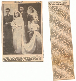
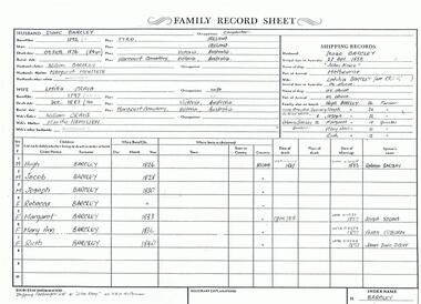
Photograph - The Wilkin Family of Sedgwick - Isaac and Letitia Barcley, 1800s-1900s
The Phil Wilkin Collection contains a series of 11 Items. The related items can be found by clicking on the reference link below. The following history of the Young family and their descendants who lived at the Springs is provided by Phil Wilkin. His Great Grandparents were Frances Young and August Wirth. Phil has also provided notes on the Wilkin Family and some history of the gold mining in Sedgwick. Frances Young's parents Joseph and Margaret Young owned the property called "The Old Place, Preston Vale or Wellington Flat" at Sedgwick near the Springs. Joseph Young owned and Managed the Standard Brewery which was located at Campbells Creek during the late 1800’s early 1900’s. Joseph and Margaret are buried in the Harcourt cemetery. In 1880 August Wirth lived at Mosquito Creek (Lake Eppalock, Victoria) when he married Frances Young. In 1902 they moved to part of Joseph Young's property. They milked cows and sold cattle for a living. One of their children Charles Wirth (Phil Wilkin's Grandfather) bought the land in 1935 after his parents had died. Charles Wirth was a councillor and also was president of the Shire of Strathfieldsaye. The "Old Place" was part of the property owned by members of the family. The old house at the Springs was burnt out by bushfire in January 1944 and much of the stonework was later vandalized by campers. The original Coliban Water Works were designed in 1863 by the Irish engineer Joseph Brady. The system included 70 kilometres of open water channels, aqueducts, syphons and tunnels to carry water (by gravity) from the Coliban River at Malmsbury, north to Castlemaine and Bendigo. Sedgwick is a locality in Central Victoria, Australia. It is located in the City of Greater Bendigo. Facilities include a public hall that opened in 1958 and CFA Rural fire station. It was named Upper Emu Creek until 1901 when it was renamed as Sedgwick after British geologist Adam Sedgwick.Seven historical documents of Isacc and Letitia Barcley who were associated with the Wilkin Family and also with the Springs near Sedgwick. There are 182 photos in this series and can be found at 8683.1 to 8683.11. The series also includes photos of the surrounding farming land and the remains of an old house. There are also some notes on the pioneers of the district.history, bendigo, coliban water, joseph brady, irrigation, the springs, sedgwick, phil wilkin collection, joeseph and margaret young, letitia and isacc barclay -
 Bendigo Historical Society Inc.
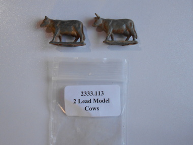
Domestic Object - QC BINKS COLLECTION: 2 LEAD COWS
Two toy lead cows that were discovered by QC Binks whilst he was metal detecting for gold. Remnants of original paintwork is evident.bendigo, gold mining, qc binks, cows, qc binks. -
 Bendigo Historical Society Inc.
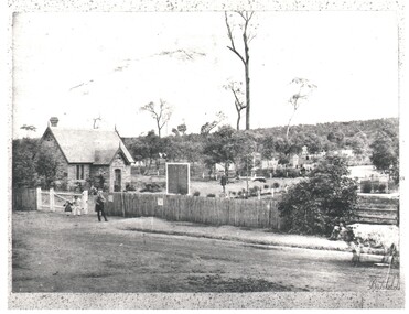
Photograph - WES HARRY COLLECTION: BENDIGO CEMETERY, 1860's
Photograph of the Bendigo Cemetery showing some headstones among the trees. Caretakers cottage ?, Chapel ?, on the left of the shot with some children and an older man in front. There is a picket fence along the front of the cemetery and a cow standing on the roadway at the right hand edge of the photo.Batchelderplace, cemetery, bendigo cemetery, carpenter street, bendigo cemetery, batchelder -
 Bendigo Historical Society Inc.
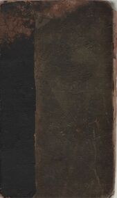
Book - HARRIS COLLECTION: FARMER'S GUIDE; A TREATISE ON THE DISEASES OF HORSES AND BLACK CATTLE
Book, dark blue faded cover, black tape on spine ( could be later addition to secure book.) 'The Farmer's Guide; a treatise on the diseased of horses and black cattle. With a selection of proved prescriptions and instruction for the management of breeding mares and cows' Published by Blackie & Son, Queen Street, Glasgow, MDCCCXXXIX (1839) Written inside front cover handwritten in pen ' Alex MacDonald, Alex Macdonald, Grieve Culbo' On next page handwritten in pen 'Alex MacDonald, Grieve Coulmony, Pariah of a Ardcheck (?) 1837' Medicine for horses, fenugreek seeds, medicine for horses' Book found in material with Harris Collection, Axedale, although no indication of Harris ownership of book.James Webb, veterinary surgeon.axedale, history, harris family farming -
 Bendigo Historical Society Inc.
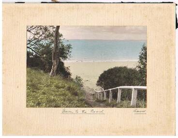
Photograph - JACK EMMETT COLLECTION: PHOTOGRAPH DOWN TO THE BEACH COWES
JACK EMMETT COLLECTION colour photograph 'Down to the beach Cowes 'mounted on cardboard - rear shows rubber stamp -'A.J. Murray commercial photographer -photo shop Cowes .'Won by (Miss ?) Ramage Ladies Table Tennis 'Bay View' Cowes Jan 1933'A.J. Murray commercial photographephotograph, landscape, cowes, 'a.j. murray commercial photographer -
 Buninyong & District Historical Society
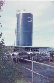
Photograph - Original Colour Photo of the Triggs Dairy Farm at Bungaree, Derek Leather, Triggs Dairy Farm, Bungaree, 1980s
Trigg Dairy Farm, built in the 1970s, showing a Rotolactor and silo for storing grass silage. Today this set up may be considered unique in this District.An example of a modern dairy operation in the 1970sColour photo of Triggs Dairy Farm, Bungaree, showing milking operation with Friesian cows in the holding yards, in the foreground. The photo includes a Rotolactor, on the left and a silo which held grass silage in the background. Built in the early 1970s this operation was considered unique in the District.trigg dairy farm operation, bunagree, 1970 -
 Benalla Art Gallery
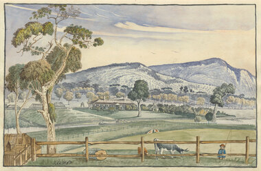
Watercolour, Elizabeth PARSONS, Cameron's Station, Pyrenees, c. 1890
Born: Isleworth, Middlesex, England 1831; Arrived: Melbourne, Victoria, Australia 1870; Died: Melbourne, Victoria, Australia 1897VictorianGift of Mrs E.E. Ledger, 1982Rural landscape with house, fences, trees hills, a creek and a small figure carrying a fishing line. Thin, dark blue grey brushed timber frame.Recto: Signed "PARSONS" in black watercolour in l.l.c of composition; Not dated; Not titledwatercolour, landscape, tree, mountains, animals, cows, figures, fence, creek, colonial, buildings -
 Uniting Church Archives - Synod of Victoria
Banner - Banners
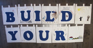
The letters of the completed banner were made by different churches within in the presbytery of Gippsland and spell a sentence, presumably, "BUILD YOUR CHURCH LORD!" Orbost was one of the churches that had the finished banner on display. 24 small banners with tabs at the top of each for hanging on a rod. 19 have large blue letters appliqued on them. Twenty two of the banners are roughly square and two are smaller and oblong. Three have no letters and are used as spacers in the four word sentence that the letters make. The banners are decorated with rural and coastal images. BN068.1 "B" with an embroidered boat with the number 1 on the sail. BN068.2 "U" fabric paint words: "LOCH POOWONG east poowong nyora strezlecki kernang athlone" BN068.3 "I" "Korumburra" BN068.4 "L" with a pelican, fishing boat with a net, shells and sand BN068.5 "D" with the UCA emblem and "BUNYIP Garfield Longwarry" BN068.6 "Y" BN068.7 "O" with fabric paint flag, ram, road and trees and a cow BN068.8 "U" BN068.9 "R" with green and yellow wattle in fabric paint BN068.10 "C" with ric-rac round the letter and three churches appliqued in the top left corner BN068.11 "H" edged with pale blue metallic fabric paint BN068.12 "U" with sunrise over the sea with gold chain sunbeams and sequins BN068.13 "R" with fine blue embroidery at each corner and only two tabs BN068.14 "C" with appliqued boat, sky and sun BN068.15 "H" with a black swan with a red beak BN068.16 "L" with appliqued and fabric painted scene of a beach, hills and city smoke on the horizon BN068.17 "O" with painted corn cobs in each corner BN068.18 "R" with cows, hills, sheep and a sack BN068.19 "D" with machine embroidered church "St Matthews Yinnar", hands "Friendship", building "UCA Yinnar", chuch "Holy Innocents YINNAR STH" "(Californian RED WOOD)", tree "BIG TREE grows at Christ Church Boolarra" BN068.20 "!" with fabric brown cow in grass BN068.21 spacer with appliqued house, bushes and barn BN068.22 spacer with appliqued sun with ribbon rays and black white and brown figures BN068.23 & BN068.24 spacer with a small UCA red dove in the centre "B U I L D Y O U R C H U R C H L O R D !"uniting church adult fellowship -
 Malmsbury Historical Society
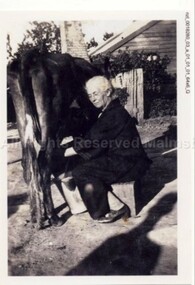
Photograph (Item), Mary (Omant) Pola Milking A Cow At Malmsbury, Malmsbury c1930
People - "Pola, Mary (Omant)" Buildings - House -
 Whitehorse Historical Society Inc.
Functional object - Butter Churn
Believed to have been owned originally by Alice and Arthur Fisher who had a 16 acre property in Mullum Mullum Road, Ringwood. The house was called Greenhill and was located at the highest point, now no. 28. They had a mixed farm including an orchard of fruit and nut trees, and a dairy cow. Alice milked the cow much to the amusement of her English family, who delighted in visiting. When the property was sold the butter churn went to Red Hill on the Mornington Peninsula. Arthur Lunt, donor has memories of its use in Red Hill, where his parents had a mixed farm. That property was sold c. 1950, and the butter Churn returned to the Ringwood Croydon area where it has remained unused for the last 65 years.|The butter churn has been in Croydon and Ringwood since 1952; it is typical of manually operated equipment in use on small properties 100 years ago.Cylindrical container, brown, mounted on board with handle underneath. To one side is a wooden handle and drive gears to spin cylinder. Cylinder has tight fitting lid and makers metal label on the side; opposite side has direction arrow embossed. Mounted on wooden base. Cream was put into churn, handle turned to spin drum until butter was produced. Five parts to the Churn.SVENSKA STOCKHOLM SWEDEN CENTRIFUGA,B.DAHLIA N0:0 SLATER PATENTdomestic items, food preparation -
 Ballarat and District Irish Association
Photograph - Colour, Clare Gervasoni, Crossley near 'Hillside" McCartney's Lane, 2014, 04/04/2014
Before 1941 "Hillside", McCartney's Road was associated with the Carroll Family. Patrick Edmund Carroll, his wife Mary Matilda Fitzgerald, and children Kathleen, Ronald and Rosemary were the last members of the family to live at and work "Hillside". Stanislaus Kelly and his wife Margaret (nee Gorman) bought the farm from the Carroll family. The couple raised six children on the land: May, Mary, Leo, Ray (Lofty), Daniel (Tich) and Bernadette. The family grew spuds and onions on the hill and milked cows, with the little dairy located on the eastern side of the house. (information from Mary Kelly)Colour digital photographs of Crossley, Victoria, near McCartney's Lane. The house depicted is "Hillside" in McCartney's Lane. The views towards an extinct volcano is Tower Hill.crossley, hillside, carroll, tower hill, mccartney's lane -
 Mt Dandenong & District Historical Society Inc.
Photograph, Fernhem, c1916
Fernhem Guest House situated in The Crescent at Sassafras. It is now a private home. An advert in the 1910 'Hotel and Boarding House Guide' states that: FERNHEM - Is beautifully situated amongst fernery glades and gladsome nature's sights. The accommodation offered is exceptional and the Proprietress with the greatest pleasure strives to make her guests during their stay, whether brief or lengthy, as happy and comfortable as human skill will allow. TERMS 30 /- PER WEEK. Milk and cream from our own cows. Correspondence invited. Mrs. TUTT, "Fernhem" SASSAFRAS.B & W photograph from Rose Series postcard showing front view of Fernhem Guest House in sassafras. There are two men, a dog and a child in the foreground with a group of people on the verandah. A large tree is in the garden RHS.The Rose Series # 1475 "FERNHEM' SASSAFRAS VICTORIAsassafras, guest house, fernhem, tutt, the crescent -
 Mt Dandenong & District Historical Society Inc.
Photograph, Across the Creek to Falls Road c1920, c1920
Mt Dandenong. Cow in paddock, looking to two houses in Falls Road. One probably belonging to a Mr. Mason.Sepia photograph of rural scene. Two cows and calf in foreground with houses, crops and trees in background.mount dandenong, falls road, cow, mason -
 Ballarat Tramway Museum
Photograph - Colour Photograph/s - set of 10, Carolyn Dean and John Phillips, 30/07/2001 12:00:00 AM
Set of 10 colour photographs taken by John Phillips or Carolyn Dean of Bungaree House, property and works being carried out. Taken on 30.07.01 unless noted otherwise. On Kodak Paper. 1859.1 - Old bathroom, now a bedroom .2 - New toilet area .3 - New bathroom area .4 - ditto .5 - extended kitchen .6 - dining area .7 - close up of extended kitchen - 15/7/01 .8 - close up of sink in old bathroom, now a bedroom - 15/7/01 .9 - Looking to the south from outside house, towards sheds and plenty of cows - 14/07/01 .10 - Looking at north end of house - 14/07/01.In blue ink on rear, date of photograph, and photographer.bungaree, houses -
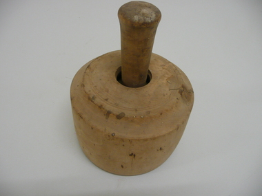 Bendigo Historical Society Inc.
Domestic Object - WOODEN BUTTER MOULD
Butter mould or press for imprinting butter, round wooden cylinder containing a circular disc on handle with carving of a cow surrounded by other carved patterns.domestic equipment, food preparation, butter mould, k166.2 k166.1 -
 Bendigo Historical Society Inc.
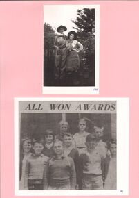
Photograph - GOLDEN SQUARE LAUREL STREET P.S. COLLECTION: STAFF IN FANCY DRESS AND CLASS
Two female staff in fancy dress, with award winners below laminated upon pink cardboard. Top, [a] Female staff dressed as cow-girls no caption. [b] Newspaper cutting illustrating seven boys, three girls with 'All Won Awards' caption.bendigo, institutions, golden square primary school -
 Bendigo Historical Society Inc.
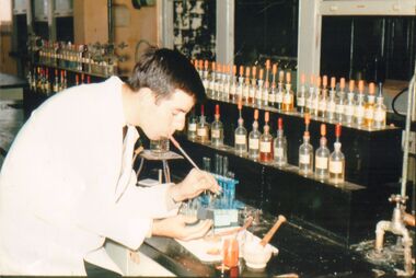
Photograph - PETER ELLIS COLLECTION: BRIT ANALYTICAL CHEMISTRY LAB
Colour photo. Taken at BRIT Small piece of paper attached to bottom of photo reads: Analytical Chemistry Lab. 1970 Semi Micro Analysis, Peter Ellis doing 'dryway'analysis Using a blowpipe and carbon block. (Strappo Eddy, ''don't did a hole big enough for a cow to calve in! '') Water pump for vacuum filtration immediate right.person, individual, peter ellis oam -
 Bendigo Historical Society Inc.
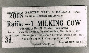
Photograph - PETER ELLIS COLLECTION: RAFFLE TICKET
Black and white photograph. White edges. Raffle ticket for Bendigo Easter Fair & Bazaar, 1921. Ticket reads: Bendigo Easter fair & Bazaar, 1921 in aid of Hospital and Asylum 2068 Raffle:---1 Milking Cow The Gift of Mrs. R Hunter, Burnewang. To be drawn on ground, on Wednesday, March 30th, 1921 Advertised in Bendigo Advertiser, Thursday, March 31st, 1921 Age and Argus, Friday April 1st, 1921 3d. J.D. Andrew, Sec. Cambridge Press. Back of photo reads: 1 X 1/2 size 12Cambridge Pressephemera, mementoes, raffle ticket -
 Bendigo Historical Society Inc.
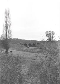
Photograph - PHOTOGRAPH. THREE ARCH BRIDGE IN BACKGROUND
Photograph. Three Arch Bridge in background. Centre left is single Cow and tall Tree. foreground Wild shrubbery. -
 Bendigo Historical Society Inc.
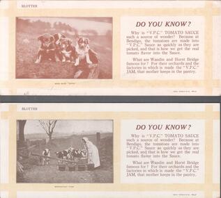
Ephemera - ADVERTISING BLOTTER FOR V.P.C. TOMATO SAUCE
Two blotters advertising V.P.C. tomato sauce. One has a photo of four little dogs looking down on something with the words: who said ''rats!''. The other has a picture of a woman with five buckets feeding a herd of cows. Underneath the words: breakfast time.bendigo, business, vpc tomato sauce -
 Kew Historical Society Inc
Journal, Kewriosity : December 1985
Celebrating 125 years / p1. Happy anniversary Kew! / p1. Dates for December / p2. [Community] Notices / p2. Christmas Services / p2. Update: Notes from Council [Local Government restructure] / Cr Phyllis Hore [Mayor of Kew] p3. Traffic management / p3. In Brief [Heavy traffic - Kew Traffic School; Yarra Bend contribution; Prospect Hill [Hotel]; Money for Mexico; Improvements to Willsmere Park; Senior Citizens' Week; Safeway go-ahead; Community Bus; Dawn patrol for dogs; Public Meeting for North Ward residents] / p4. 125th Anniversary supplement [graphic collage] / p5. Kew becomes a municipality / p6. "Ma Dalley" / p6. History of Kew Library / Alex Tarr [City Librarian] p6. [Historic] Kew dates / p7. Kew's Crest / p6. The Outer Circle revisited / Joan Barrett p6. Getting the news to Kew [Chronological history of Kew newspapers] / p8-9. Of Councils past [What rubbish ...; Kew by moonlight; Evil practices; All quiet on the Council front; Things change?; In the marketplace; Kew goes it alone; No cows for Kew; Voting is compulsory; In the beginning ...] / p10. Finding out about our history / p10. From the old "Rec" to the new Recreation Centre / p11. Kew's history in houses - your guide to style and period / p12. 'Ow Commissioners catered for Kew [poem] /p12. Welcome Councillor Timms / p13. Govt grant for Recreation Centre / p13. Volunteers needed for Kew Meals on Wheels / p13. Holday programs / p13. Kew Community House [Rhonda (McCaw) takes over; We're expanding!; Volunteer Child Care workers; Suggestion box; T.O.P. at the house; Christmas break-up] p13. Why Kew? p13. Youth Page [Making the most of the holidays; What does Christmas mean to you? Holiday program] / p13. 1888 Organ restoration recalls Kew businessman [Alfred Fuller] / p14. The Citizens' Advice Bureaux needs new volunteers / p14.Kewriosity was a local newsletter combining Kew Council and community news. It was published between November 1983 and June 1994, replacing an earlier Kewriosity [broad] Sheet (1979-84). In producing Kewriosity, Council aimed to provide a range of interesting and informative articles covering its deliberations and decision making, together with items of general interest and importance to the Kew community and information not generally available through daily media outlets.non-fictionCelebrating 125 years / p1. Happy anniversary Kew! / p1. Dates for December / p2. [Community] Notices / p2. Christmas Services / p2. Update: Notes from Council [Local Government restructure] / Cr Phyllis Hore [Mayor of Kew] p3. Traffic management / p3. In Brief [Heavy traffic - Kew Traffic School; Yarra Bend contribution; Prospect Hill [Hotel]; Money for Mexico; Improvements to Willsmere Park; Senior Citizens' Week; Safeway go-ahead; Community Bus; Dawn patrol for dogs; Public Meeting for North Ward residents] / p4. 125th Anniversary supplement [graphic collage] / p5. Kew becomes a municipality / p6. "Ma Dalley" / p6. History of Kew Library / Alex Tarr [City Librarian] p6. [Historic] Kew dates / p7. Kew's Crest / p6. The Outer Circle revisited / Joan Barrett p6. Getting the news to Kew [Chronological history of Kew newspapers] / p8-9. Of Councils past [What rubbish ...; Kew by moonlight; Evil practices; All quiet on the Council front; Things change?; In the marketplace; Kew goes it alone; No cows for Kew; Voting is compulsory; In the beginning ...] / p10. Finding out about our history / p10. From the old "Rec" to the new Recreation Centre / p11. Kew's history in houses - your guide to style and period / p12. 'Ow Commissioners catered for Kew [poem] /p12. Welcome Councillor Timms / p13. Govt grant for Recreation Centre / p13. Volunteers needed for Kew Meals on Wheels / p13. Holday programs / p13. Kew Community House [Rhonda (McCaw) takes over; We're expanding!; Volunteer Child Care workers; Suggestion box; T.O.P. at the house; Christmas break-up] p13. Why Kew? p13. Youth Page [Making the most of the holidays; What does Christmas mean to you? Holiday program] / p13. 1888 Organ restoration recalls Kew businessman [Alfred Fuller] / p14. The Citizens' Advice Bureaux needs new volunteers / p14. publications -- city of kew (vic.), kewriosity, council newsletters, community newsletters -
 Kew Historical Society Inc
Photograph - Yarra at Kew, 1925
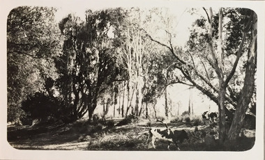
Henry Beater Christian (1886-1962) , was a descendant of one of the earliest settler families in Kew. Employed at the Kew Asylum as a 'public servant', he was a skilled amateur photographer, photographing numerous scenes in Kew and on his travels around Victoria. The majority of his photographs date from 1916 to 1929. His finest photographs are housed in two photograph albums. Digital copy of a photograph from page 4 of the 47-page photograph album containing 261 gelatinous silver images, loaned by Diane Washfold with permission given to digitise and hold a copy in our collection. This photograph is of a bank of the Yarra at Kew where cows graze among the trees"Yarra at Kew"henry beater christian (1886-1962), landscape photography, kew (vic.) — yarra river, christian-washfold collection, photograph albums, dairying, dairy farms -
 Kew Historical Society Inc
Album - Photographs of heritage sites in Victoria, Eva Grant, 1964-66
Eva Grant was a member of the Kew Historical Society. Three albums in the collection were created by her, this one, the third created between 1964 and 1966. They were donated to the Society by her daughter in 2010. Each of the albums includes photographs and newspaper cuttings collected on her travels to historic places in South East Australia in the 1950s and 1960s. Particular structures photographed in this album include: Barnawatha (Vic.) - The Hermitage | Beveridge (Vic.) - Stone cottage where Ned Kelly was born. | Brighton - St Andrew’s Church graveyard. | Chiltern (Vic.) - lake view [missing] | Cowes (Vic.) - ‘Broadwater’ [originally home of Henty-Wilson family], demolished 1965; Bell of the Speke wreck; Edward’s tree. | Euroa (Vic.) - Habbies Howe | Fairfield (Vic.) - Dight’s Falls; John Dight. | Fernshawe (Vic.) - Queen Mary tree. | Jolimont (Vic.) - Old railway tunnel linking the first Government House (1964); Sign identifying location of first Government House. | Kew (Vic.) - Cairn at Dight’s Falls; Canoe tree, Bowyer Avenue. | Kyneton - De Grave’s Flour Mill - “C”. | Maldon (Vic.) - Chinese oven; Macarthur’s House; Maldon’s oldest resident; Chinese graves x 2; [Beehive Chimney]. | Marysville (Vic.) - Centenary cairn | Mitcham (Vic.), Mud brick house x 2, Deep Creek Road. | Melbourne (Vic.) - St Paul’s Cathedral [renovation] (1964); Wreckers at Damman’s Corner, cnr Bourke and Collins Streets (1964); Princess Gate project x 2 (1964); Colonial Storekeeper’s building on cnr King and Bourke Streets (1966); Early observatory 1861-3; the Honey Memorial. | Mt Oberon (Vic.) - [obsolete] radio telephone dish. | Seymour (Vic.) - Habres (sic) House x 3.| Swan Hill (Vic.) - Major Mitchell’s Cairn (12/1964); Headstone of Andrew Beverage AM (12/1964). | Templestowe (Vic.) - Finn’s Hotel. | Thornton (Vic.) - Eildon Station. | Werribee (Vic.) - Chirnside Memorial [Presbyterian] Church; gaslight beside church | Location unknown, but possibly Swan Hill - Brick house; Wooden bullock dray. | Location unknown - Headstone of John Furlonge 1835.Important record of significant heritage properties in Victoria, many of which have since been demolished.30 page spirex bound drawing book including photographs and newspaper articles of historic buildings in Victoria. The front cover has a picture of a steam boat. The cover is encased in plastic. A number items in the album are annotated with written commentary by Eva Grant who compiled the album. Annotations and transcriptions by Eva Grant on most imageseva grant, photograph albums, heritage places - victoria