Showing 1651 items matching "junctions"
-
 Whitehorse Historical Society Inc.
Photograph, Eriksson Family, C.1903
Black and white photo of Eriksson Children outside Family Home - 17 Junction Road, Nunawading C.1903. Girls are probably Olga and Mary.eriksson, olga, mary, junction road, blackburn north, no. 17. -
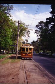
 Melbourne Tram Museum
Photograph - Black & White Photograph/s, Ray Jackson, c1969
Black and White photograph of W5 812 outbound at St Kilda Junction 31/8/1969. Tram has the destination of Carnegie Route 4trams, tramways, st kilda junction, carnegie, route 4, tram 812 -
 Ringwood and District Historical Society
Photograph, Pratt's Junction Estate, Ringwood - 1923. Oliver St., Georges Rd., Junction St. 24/11/1923. 3 pounds deposit and 1 pound per month. F.V. Parker agent. 86 lots. Free rail tickets and motor transport
Catalogue card reads, "Pratt's Junction Estate 1923. Oliver St., Georges Rd., Junction St. 24/11/1923. 3 pounds deposit and 1 pound per month. F.V. Parker agent. 86 lots. Free rail tickets and motor transport." -
 Melbourne Tram Museum
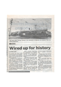
Newspaper, "Wired up for history", mid 1990's
Newspaper clipping from possibly a local paper, undated, c1995, titled "Wired up for history", about the Grand Union at Balaclava Junction being added to the National Trust listing, supported by the City of Glen Eira. Notes Alan Brown and PTC have recognised the location. Has a photo of two Z class trams using the junction. Written by Darren Lunny.trams, tramways, balaclava junction, grand union, national trust, ptc -
 Kew Historical Society Inc
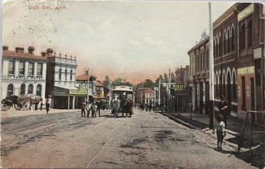
Postcard, High Str., Kew, c.1906
The Kew Historical Society's postcard collection includes views of Kew, Melbourne and Greater Melbourne as well as those including overseas scenes sent or received from Europe or the Middle East. They date from the 1890s to the 2000s. These postcards may or may not include the name of the publisher or printer. A number of the cards were published as parts of popular series. A way of dating early postcards is to identify whether the reverse was divided by a central line which became the norm after 1902 in the United Kingdom. However, other postcards produced after this date do not always conform to this print layout.Polychrome postcard of High Street, Kew looking west towards Kew Junction. The photograph was also printed in monochrome format by the publishers, with different names and additions.Reverse - (to) Miss __. J. Thompson, "Dry Lake", Kerang (from) Very sorry indeed to hear of your Mother's illness. Sincerely hope all quite well ere this. Still going about very tired waiting __ being away. Love to all M.B.L.high street -- kew (vic.), postcards -- kew (vic.), horse tram -- kew (vic.) -
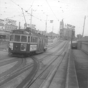
 Melbourne Tram Museum
Photograph - Block Mounted Photograph, c1934 original photo, print - c1980
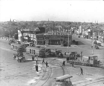
Block mounted photograph of a scene c1934 at St Kilda Junction, featuring re-surfacing of the junction tram track - used on page 3 of the December issue of Bellcord. "St Kilda Junction looking northward as tramway roadworks near completion. Workmen are dispersing gravel to cover recently applied bitumen, perhaps from the tanker (centre). Ballast Motor 11 pushes a ballast trailer ahead of W2 571 to St Kilda Beach and a second car to East Malvern. A horse drawn tower wagon (left), heavy roller (foreground) and private motor vehicles stand by. On the Punt Road corner is a petrol station advertising a then popular brand, Atlantic Ethyl, advertising Ford cars. Segments of the intricate junction overhead and trackwork are visible." 2nd copy added from the Donation by David Webb of the Keith Kings collection - in box 89.trams, tramways, st kilda junction, tower wagon, trackwork, freight tram, ballast motor, trailers, tram 11, tram 571 -
 Kiewa Valley Historical Society
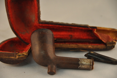
Pipe Tobacco Smoking, Circa 1889
Pipe smoking has been in vogue for centuries, and in Australia it was a symbol of the "discerning smoker" such as the landed gentry or men of professional status. This pipe, of the Standard Canadian style, would have emigrated to Australia with its owner, a reasonable young professional or executive of the Hudson Bay Tobacco Company in the late 1800s or early 1900s. It is the type of pipe well suited to a harsh rural backdrop and with its owner found the Kiewa Valley a more relaxed environment than the Canadian Indian locations. The value of this pipe to the original owner, who would have sealed many trade contracts during the Canadian Indian smoke rituals In the late 1800s, is indicated by the long voyage to Australia and the Kiewa Valley. However with the health related restrictions placed on public smoking in the early 2000s, these tobacco pipes were not immune from the legislation, and even though the pipe smoke was not as offensive as cigarette smoke it still came under the umbrella of smoking. Pipes were also used in the process of inhaling illicit drugs i.e. marijuana, but this use was limited to a very few and not with this pipe. Smoking in the second millennium is being phased out as a social habit in Australia but may affect the few "private" smoker and has, as the United States prohibition era (alcoholic drinks) did, spawn an illicit trade in cheap contraband tobacco. Pipes such as this item show that smoking was not only part of the lifestyle of the era but also that it was part of a ritual (especially to the Indians of the Canada Hudson Bay region) that sealed a brotherhood not only socially but also politically and economically.This type of pipe lends itself well to the rural setting of the Kiewa Valley and although it is a very exclusive pipe it blended into the tobacco industrial environment of the Kiewa Valley and its surrounding districts. The Kiewa Valley region was up until the late 1900s part of the Australian Tobacco industry and the levels of men smoking pipes was enhanced by the readily supply, "off the fields", of tobacco leaves and the attitude to city based smoking restrictions was one of resentment.This pipe has a straight shank and stem and its style is 'standard Canadian'. The pipe has a permanent filter and a stainless steel band with the initials of the Hudson Bay Tobacco Company and its seals stamped on it.. The bowl and shank are one piece of appropriate shaped wood. The bit and bore are made from bakelite (dark brown in colour). The pipe is fashioned in the form of the clay pipes used by trappers, in the late 1800s early 1900s. It has a "rest" lug at the bottom of the bowl similar to clay pipes. This pipe has its own pipe case with wood reinforcement running the entire pipe shaped contour.On the stainless steel at the mortise and tenon junction is stamped "HP" and below that are stamped symbols of a ship's anchor, a lion and a tobacco leaf.tobacco, pipe smoking, smoking accessories -
 Kiewa Valley Historical Society
Photograph - Folder of Photographs (KVHS 1150 A - F) – Photocopied set of black and white photographs from the display folder (pages 1 - 8) put together by KVHS to document life on the Kiewa Valley Hydro-electric Scheme
Although the Kiewa Hydro-Electric Scheme was first proposed in 1911, construction did not commence until 1938. As part of the push to cut electricity costs and diversify supply, the Victorian Government (circa 1930) initiated the conversion from primarily brown coal supply to hydro – electricity. Field investigations during the 1940’s resulted in a new proposal for a scheme that had more than double the capacity of the 1938 scheme. The Kiewa Hydroelectric Scheme became the largest scheme of its kind in the State Of Victoria and the second largest scheme in Australia. The number of personnel involved in the planning and construction of the scheme increased dramatically. During the late 1940’s, most activity centred around the construction of the West Kiewa Power Station, Rocky Valley Reservoir, McKay Creek Power Station and the Bogong Creek Aqueduct.A common thread across all the larger hydro scheme constructions was the need for workers, both qualified and unqualified who came from around the world seeking a new life for themselves and their families. New accommodation and facilities were required for the army of workers engaged in construction in often remote and wild areas. The SEC had a high demand for timber, and set up the first of a number of sawmills at Bogong Creek in 1939 and set up the first hardwood logging in the headwaters of the Kiewa River. These new ‘towns’ such as Mt Beauty and Bogong, survived, serving the needs of operational personnel and their families, and expanding with growth of new industries. Mount Beauty, and to a lesser extent Bogong, are among these places. Large A3 size spiral bound display folder containing 21 of 58 pages of photocopied black and white photographs of various aspects of the early days of the Kiewa Valley Hydro-electric scheme including equipment, various work sites and photographs of workers and their families. 1-Front page; 2-Security gate at Mt Beauty Camp; 3-Channel 1 on East Kiewa River; 4-Junction Dam – Diversion Tunnel Inlet; 5-Sawmill; 6- Homan’s Gap Sawmill; 7 Junction Dam: 8-Homan Dam Site-Diamond Drilling on River Buttress; 9- Homan Dam Site View Upstream 10-Homan Dam Investigation Camp 1-Windsor & Newton Visual Diary 60 sheet (120 pages) 11’ x 14’ 280 x 356mm 110 GSM Acid Free Drawing Paper 2-1940-Security Gate on Mt Beauty side of Kiewa River bridge. Part of old Mt Beauty camp and mess in background 3- STATE ELECTRICITY COMMISSION OF VICTORIA Date; 11.3.40 Time: 10.30am No K35 Kiewa Hydro Electric Works. Diverting East Kiewa River into Channel Page number 1 4-STATE ELECTRICITY COMMISSION OF VICTORIA Date: 5.4.40 Time: Noon No K58 Kiewa Hydro Electric Works. Junction Dam – Diversion Tunnel Inlet – Normal Flow Page number 2 5- STATE ELECTRICITY COMMISSION OF VICTORIA Date: 19.8.42 Time: 2.30pm No K883 Kiewa Hydro Electric Works. Sawmill – General View Page number 3 6- STATE ELECTRICITY COMMISSION OF VICTORIA Date: 12.1.42 Time: 2.00pm No K540 Kiewa Hydro Electric Works. Homan’s Gap Sawmill – General View Page number 4 7- STATE ELECTRICITY COMMISSION OF VICTORIA Date: 12.1.42 Time: 2.00pm No K540 Kiewa Hydro Electric Works. Junction Dam – General View looking upstream Page number 5 8- STATE ELECTRICITY COMMISSION OF VICTORIA Date: 16.11.45 Time: 10.32amm No K52153 Kiewa Hydro Electric Works Homan Dam Site – Diamond Drilling on River Buttress Page number 6 9-STATE ELECTRICITY COMMISSION OF VICTORIA Date: 15.1.45 Time: 4.10pm No K1781 Kiewa Hydro Electric Works Homan Dam Site – View Upstream Page number 7 10- STATE ELECTRICITY COMMISSION OF VICTORIA Date: 15.1.45 Time: 4.10pm No K1781 Kiewa Hydro Electric Works Homan Dam Investigation Camp 1944 – 1945 Page number 8 secv; kiewa hydro electric scheme; mt beauty; bogong; construction work; -
 St Kilda Historical Society
Photograph, St Kilda Junction Construction, c. 1973(?)
in notes (not on photograph)Junction Hotel, St Kilda Junction prior to demolition in 1973 - this is on the far leftof the photograph, church spire, Barkly street in backgroundpoor black and white photograph unmounted -
 Ballarat Tramway Museum
Negative - Set of 3, Campbell Duncan, 1975 or 1976
Yields information about the appearance of No. 27 and Depot Junction mid 1970's.Set of 3 selected negatives from a group of about 22 negatives showing the activities by the BTPS in Wendouree Parade c1975/1976. Photographed by Campbell Duncan (could be Paul Nicholson). .1 - No. 27 arriving at Depot Junction with destination of Carlton St and a Twin Lakes sign. .2 - ditto, picking up passengers, with Richard Gilbert driving. .3 - ditto leaving Depot Junction. trams, tramways, btps, wendouree parade, depot junction, tram 27 -
 Whitehorse Historical Society Inc.
Newspaper - Article, Historic homestead, 1/03/2000
Property advertisement for 3 bedroom Edwardian timber house at 17-21 Junction Road, Blackburn North, for auction on 11 March 2000. Agent: Argyle Partners.junction road, blackburn north, no 17 - 21., argyle partners, auctions -
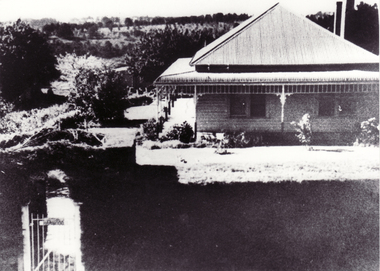
 Whitehorse Historical Society Inc.
Photograph, 'Harwood' 17 - 21 Junction Road, Blackburn
Black and white photo of 'Harwood' a home at 17 - 21 Junction Road, Blackburn. Home was be wrongly described as the Slater home. See ND1270 at G-H 53.slater, william henry -
 Whitehorse Historical Society Inc.
Photograph - Black and white photograph, 'Harwood' 17 - 19 Junction Road Blackburn
Black and white photo of 'Harwood' a home at 17 - 21 Junction Road Blackburn. Home was wrongly described as the Slater home. See ND1270 at G-H 53.harwood, junction road, blackburn north nos. 17-21 -
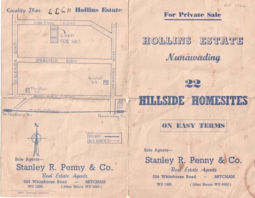 Whitehorse Historical Society Inc.
Document, Hollins Estate, 1955
Private sale of 22 hillside home-sites on Junction Road, Blackburn, called Hollins Estate by Stanley R. Penny & Co., 524 Whitehorse Road, Mitcham.hollins estate, stanley r. penny & co., real estate agents, blackburn, junction road, suto, joyce -
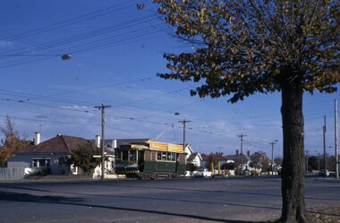
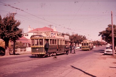
 Ballarat Tramway Museum
Slide - 35mm slide/s, Keith Caldwell, 12/03/1962 12:00:00 AM
Yields information about the appearance of the depot area and shunting trams such as No. 39.Agfa colour slide, white cardboard mount, photo by Keith Caldwell on 12/3/1962 of: Tram 39 passing the SEC depot junction Wendouree paradeIn ink "Ballarat 12.3.62"tramways, trams, wendouree parade, depot junction, tram 39 -
 Ballarat Tramway Museum
Photograph - Colour Photograph/s, Warren.Doubleday, 1/10/1993 12:00:00 AM
Colour Photograph, postcard size of BTM tram 26 travelling southbound in Wendouree Parade near depot junction. Photo taken October 1993. (2 copies)btm, street scene, wendouree parade, tram 26 -
![Footpath on High Street [Kew]](/media/collectors/550653872162f11fb04854aa/items/6132d892e06408664db76a00/item-media/6132d922e06408664db7752b/item-fit-380x285.jpg) Kew Historical Society Inc
Kew Historical Society IncPhotograph - Footpath on High Street [Kew], 1989
Photograph of a footpath in High Street Kew, probably donated by the City of Kew's Engineer's Department.Small, original colour positive [polaroid] photograph of the footpath on the north side of High Street, Kew, looking towards Kew Junction from the vicinity of the Greyhound Hotel."Looking back from pub / High St footpath / 22/8/89"high street -- kew (vic.), street works, footpaths -
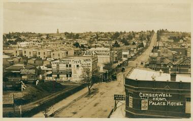 Camberwell Historical Society
Postcard - Photo postcard, Camberwell from Palace Hotel, 24-01-1909
Frazer and Vallance Photo Post Card. Origin and writer of postcard unknown.Frazer and Vallance photo postcard showing view looking south from the Palace Hotel, Camberwell Junction. Writing on back of postcard, dated Jan 24th 1909. Writing on back of postcard which reads: My Dear Bella, I received your card on Wednesday and was quite pleased to get it, thank-you very much. This is the place I am living in at present - I rather like it, it is quite a change after Yack. Alex. P.S. has Hill any intentions of coming down next month. I have not saw L.C. yet. I never go out that way. Rember me to all at home. -
 Ballarat Tramway Museum
Slide - 35mm slide/s - set of 4, Noel Simons, 24/05/1971 12:00:00 AM
Set of 4 transparencies taken on 24/5/1971 on Kodak mounts. 1199.1 - No. 21 in High St. at junction with old High St., near Fire Station Loop. Tram has two SEC roof ads. 1199.2 - No. 21 in High St. between Shamrock and Thistle Sts. Photo taken after the tram has passed the photographer. 1199.3 - Photo of a green box containing timetables for the four Bendigo routes. Located at Charing Cross. 1199.4 - Bendigo No. 23 en route to Eaglehawk at Charing Cross, with two SEC roof ads 'Everything's fine in my all electric kitchen' and "Switch to electric cooking'. Has the Ezywalkin building and the Beehive building in the background. Information written on in black ink and date stamped on purple ink. 1199.1 - "No. 21 in High St. at junction with old High St., near Fire Station Loop." 1199.2 - "No. 21 in High St. between Shamrock and Thistle Sts." 1199.3 - "Bendigo Tramways timetable at Alexandra Fountain Charing Cross." 1199.4 - "No. 23 at Alexandra Fountain Charing Cross, Bendigo." tramways, trams, bendigo, timetables, charing cross, high st., tram 21, tram 23 -
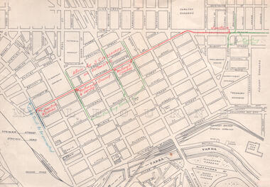 Melbourne Tram Museum
Drawing - LaTrobe St - track proposal, Melbourne & Metropolitan Tramways Board (MMTB), late 1940s
Drawing is marked up in red to show the proposed track work in LaTrobe St, noting junctions, crossings, and green for existing north-south tracks. Has a note that the cable track in Spencer St was to be converted and a junction installed at the corner of LaTrobe and Spencer Sts. This junction was not installed, just the curve into Spencer St.Yields information about the LaTrobe St planning of the late 1940s.Drawing - marked up plan with red and green lines, folded with punch holes on the left hand side.latrobe st, new tramways, trackwork, cable trams -
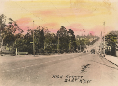 Kew Historical Society Inc
Postcard - High Street, East Kew, c.1927
High Street, Kew is the main Road in Kew. It was once also known as Bulleen Road, or Main Street. This section of the road is in Kew, although the narrow section on the right hand side of the photo is now Kew East. High Street progresses through a number of significant road junctions: beginning at Barkers Road; progressing through the intersection of Studley Park Road, Denmark Street and Princess Street at Kew Junction; branching left at the junction with Cotham Road; before reaching the junction with Valerie Street and Harp Road. It reaches its end at the junction of Burke Road, Kilby Road, Bulleen Road and High Street itself. An early photograph of this iconic Memorial that locates it in its context. Small, colorised real photo postcard of High Street, East Kew. Electric light poles line the road. Victoria Park is on the left and further on the horizon is the Boroondara General Cemetery.high street -- kew (vic.), victoria park, tram lines -- kew (vic.) -
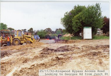 Ringwood and District Historical Society
Photograph, Eastlink Ringwood Bypass Construction-Access Road looking to Georges Road from Junction St. 25/11/1992
Colour PhotographWritten on back of photograph: "25/11/92. Ringwood Bypass Access Road. Junction St looking towards Georges Rd" -
 Kiewa Valley Historical Society
Postcard - Junction Dam - Circa 1950, Circa 1950's
This postcard was produced in the 1950's for the tourist trade in the Kiewa Valley and Alpine region. It encompasses the period when the State of Victoria was pressured by the ever increasing demand by industry and its population for electricity supplies. Hydro electricity was seen as an untapped natural resource to quench this demand. The Victorian Alps and the rivers flowing into its valleys was ideal for the construction of the Kiewa Hydro Electricity Scheme. The late 1940's saw the development of this scheme and the changing of sections of alpine landscape is covered by this and other postcards/pictures (tourists, construction workers, and established rural populations). This period in time was before the established wildlife and forest/nature groups became political activist who changed legislative acts to protect the environment.This rural region (Kiewa Valley/alpine plains) was at most only significant to a smaller group of winter sports, summer hikers/horse riders and rural farmers/graziers. The numbers of tourists and the increase in the local resident population was boosted by the construction of the Hydro Electricity Scheme. This influx to the regional population resulted in a corresponding diversity in services and brought about an environment that responded to a growing level of tourists and thereby permitting this industry to grow more rapidly than it would have naturally. This postcard details an attraction to the "cleaner" method of providing electricity. This postcard was purchased in 1950 by a surveyor at Landford's Gap.This black and white photograph is a Valentine's postcard, from a V2 Argus photograph. It is on a 200g/m paper density with only the photo side gloss.Front "JUNCTION DAM & SPILLWAY, BOGONG KIEWA HYDRO-ELECTRIC PROJECT" on the flip side "VALENTINE'S POST CARD " "A GENUINE PHOTOGRAPH"kiewa valley tourism, victorian alps, alternate energy supplies, alpine population growth, junction dam, secv -
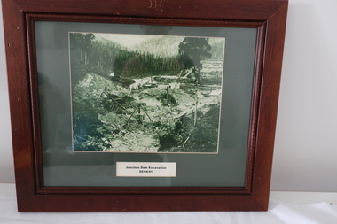 Kiewa Valley Historical Society
Set of 6 framed photographs - Kiewa Hydro Electric Scheme
Official photos - Kiewa Hydro Electric Scheme constructed by State Electricity Commission of VictoriaOfficial photos of KHES in the Kiewa Valley1. Junction Dam Excavation - 5th April 1941 2. Bogong Residential Area Development - 24th April 1940 3. Beginning of Mt Beauty Township - 20th February 1947 4.Pretty Valley Bridge - 9th September 1940 5. Junction Dam - General View from Downstream - 15th September 1943 6. Construction of Dam Wall for Rocky Valley Dam - 1958khes, secv -
 Ballarat Tramway Museum
Slide - 35mm slide/s, Travis Jeffrey, c1962
Agfa plastic mount (blue base, white cover) with a photo of Bendigo 5 and No. 20 in McCrae St, Bendigo at the junction with Arnold St, or the junction for the depot. Appears to be changing crews, has driver board, conductor about to board, with two others at the rear of the tram, one in a SEC uniform. Taken c1962, spring or early summer. No. 5 has a Cinzano roof advertisement and destination of North Bendigo."BES 18" in penciltramways, trams, bendigo, mccrae st, depot junction, crews, tram 5, tram 20 -
 Melbourne Tram Museum
Photograph - Digital Image, Kevin O'Reilly, Kew Junction from the north east, towards the city, c1930's
Image from CD (Compact Diskette for use in computers) - see Reg Item 135. Image titled "Kew Junction' on CD, of looking Kew Junction from the north east, towards the city, shows the Kew railway station precinct. Has a inbound W class tram picking up passengers at the Kew Post Office. A summer day. Possibly late 1920's, early 1930's.trams, tramways, kew, kew junction, kew post office, high st -
Port Melbourne Historical & Preservation Society
Photograph - Aerial view Maribyrnong and Yarra rivers and Coode Island, c. 1976
Donated to City of Port Melbourne by Councillor Russell GRIFFITHS.Aerial photograph taken from above junction of Yarra and Maribyrnong rivers showing oil and chemical storage farm at Coode Island and four container vessels at Swanson Dock.transport - shipping, piers and wharves - miscellaneous, swanson dock -
Whitehorse Historical Society Inc.
Document, History of Burwood East State School, 1/03/1969
Document on Burwood East Primary School, originally a non-vested school, no 184 Harkaway, located at the junction of Highbury and Blackburn Roads whose first building was erected in 1861.burwood east primary school no. 454, nunawading common school no 454 -
 Whitehorse Historical Society Inc.
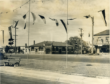
Photograph, Mitcham Hotel 1954
Originally called the Reserve Hotel; built in 1895Black and white photograph and negative of the Mitcham Hotel taken in 1954 from the north-west corner of the junction of Mitcham and Whitehorse Roads (Note early introduction of traffic lights)mitcham hotel, mitcham road, mitcham, whitehorse road, reserve hotel, byrne's -
Kew Historical Society Inc
Flyer, 1 Princess Street, Kew, 1994
1 Princess Street, Kew: 7 Storey Office Building. High rise development in Kew Junction. Laminated real estate advertisement. See copyright information below.kew junction