Showing 1252 items matching "land sale"
-
 Whitehorse Historical Society Inc.
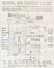
Document, Kings Padddock Blackburn
... Plan showing land for sale at Kings Paddock, Blackburn... t.r.b. morton & son Plan showing land for sale at Kings Paddock ...Plan showing land for sale at Kings PaddockPlan showing land for sale at Kings Paddock, Blackburn (second section).Plan showing land for sale at Kings Paddockauctions, kings paddock, blackburn, south parade, laburnum street, the avenue, fuchsia street, laurel grove, main street, t.r.b. morton & son -
 Bacchus Marsh & District Historical Society
Map, Gaynor Street Land Sales, Maddingley, circa 1880s-1890s
... This map was produced for a major sale of land...A single page paper map showing land allotments for sale...This map was produced for a major sale of land ...This map was produced for a major sale of land in the Maddingley area of Bacchus Marsh. The precise date of the sale has not been determined. Features present on the map such as the Bacchus Marsh Railway Station indicate the land sale must have taken place some time after 1887 when the Railway Station opened. A single page paper map showing land allotments for sale in the Maddingley area of Bacchus Marsh. Locations shown include Gaynor Street, Maddingley Road South, Parwan Road, Mitchem Street, Typpynge Street, Finn Street and East Maddingley Road. . The map is pasted into a bound volume containing 76 maps or plans in total. High resolution digital image stored on BMDHS computer network. bacchus marsh victoria maps, maddingley victoria maps, land use, maddingley victoria history, land sales bacchus marsh, land sales maddingley -
 Whitehorse Historical Society Inc.
Article, Carving up the Eastern Suburbs
... , and the 'Queens Park Tenner' issued as a deposit for a land sale, cnr...' issued as a deposit for a land sale, cnr Station Street ...Newspaper article about Tommy Bent and Sir Benjamin Benjamin and their land buys in the Eastern SuburbsNewspaper article about Tommy Bent and Sir Benjamin Benjamin and their land buys in the Eastern Suburbs, and the 'Queens Park Tenner' issued as a deposit for a land sale, cnr Station Street and Canterbury Roads (copy shown)Newspaper article about Tommy Bent and Sir Benjamin Benjamin and their land buys in the Eastern Suburbsland subdivision, station street, box hill, canterbury road, bent, thomas, benjamin, benjamin (sir), queens park estate, queens park tenner, freehold investment and banking company of australia ltd -
 Bendigo Historical Society Inc.
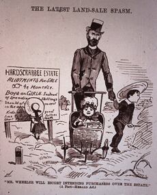
Slide - DIGGERS & MINING. LIFE OF THE SELECTORS, c1884
... 'The Latest Land-Sale Spasm.' Under picture ''Mr Wheeler Will Escort... & Mining. Life Of The Selectors. Slide headed 'The Latest Land-Sale ...Diggers & Mining. Life Of The Selectors. Slide headed 'The Latest Land-Sale Spasm.' Under picture ''Mr Wheeler Will Escort Intending Purchases Over The Estate.'' (A Fact - Herald Ad.) Ad on sign board is advertising Hardscrabble Estate Allotment For Sale 4s Monthly BOYS and GIRLS Instead Of Spending . . . Picture depicts a gentleman with 3 children one in pram. Markings: Life Of The Selectors 1860 - 1890 Set 432 No. 19. The Latest Land Sale Spasm - ''Sydney Bulletin,'' August 23, 1884. Used as a teaching aid.Visual Education Centreeducation, tertiary, goldfields -
 Federation University Historical Collection
Document, Archibald Fisken, Bill of Sale, 1855, 28/09/1855
... Archibald Fisken John Foushaw bill of sale land transfer squatter ...Hand written bill of sale between A. Fisken and John [Bonshaw?]Lal Lal September 28th 1855 I hereby agre to hand over to Mr John Bonshaw my right and title to lot 33 in the parish of Kirit Berrit and Fifty Pounds Sterling in Exchange for his lot on the Moorabool [?], lot 3 in the same Parrish. Each agreeing to trade & transfer made out, as soon as we get our grants from the Crown. A. Fisken. archibald fisken, john foushaw, bill of sale, land transfer, squatter, john bonshaw -
 Whitehorse Historical Society Inc.
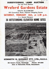
Document, Wreford Gardens Estate, 1/02/1963 12:00:00 AM
... Pamphlet advertising land for sale on Wreford Gardens... Wreford Gardens Estate, Pamphlet advertising land for sale ...Wreford Gardens Estate,Pamphlet advertising land for sale on Wreford Gardens Estate, Blackburn 16th February, 1963Wreford Gardens Estate,land sales, wreford gardens estate, blackburn south, abercromby road, edinburgh road, baird court, barrina street -
 Whitehorse Historical Society Inc.
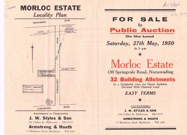
Document, Morloc Estate
... Advertising brochure, including plan of land for sale... of land Advertising brochure, including plan of land for sale ...Advertising brochure, including plan of landAdvertising brochure, including plan of land for sale in Morloc Estate, Nunawading off Springvale RoadAdvertising brochure, including plan of land morloc estate nunawading, land subdivision, springvale road, nunawading -
 Ringwood and District Historical Society
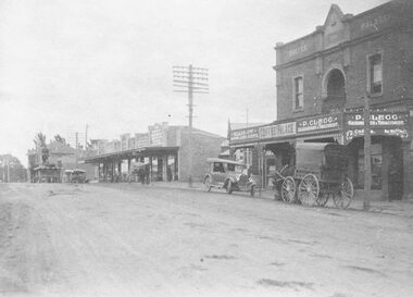
Photograph, Maroondah Highway Central, Ringwood. Coffee Palace and shops along Main Street between Adelaide Street and Melbourne Street. c1920's
... a land sale brochure and shows cars and horse drawn vehicles... a land sale brochure and shows cars and horse drawn vehicles ...Black and white photographWritten on back of photograph: "Land values - Main Street, Ringwood - land worth £50 pounds a foot." Image is taken from a land sale brochure and shows cars and horse drawn vehicles parked in front of buildings. -
 Ringwood and District Historical Society
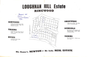
Document - Folder, Subdivision Map - Loughnan Hill Estate, Ringwood, Victoria - circa 1960
... Open centre page of land sale brochure glued to manilla... for further sale information) Open centre page of land sale brochure ...Open centre page of land sale brochure glued to manilla folder. Map of residential and shop sites in Burlock Road (later Burlock Avenue), Adolphson Avenue and Felix Crescent, Ringwood, with summary of estate facilities and local services. Agent - T.G. Newton.(Page glued to manilla folder prevents access to front page for further sale information) -
Whitehorse Historical Society Inc.
Document, Land Transfer, 1919
... Of sale of land Vol 4035 Folio 806811 to George Dodsworth... of sale of land Vol 4035 Folio 806811 to George Dodsworth 10 Jun... Mitcham melbourne Of sale of land Vol 4035 Folio 806811 to George ...Notice from Patrick Joseph Markham to Commissioner of Taxes.Notice from Patrick Joseph Markham to Commissioner of Taxes of sale of land Vol 4035 Folio 806811 to George Dodsworth 10 Jun 1919Notice from Patrick Joseph Markham to Commissioner of Taxes.markham, patrick joseph, dodsworth, george, whitehorse road mitcham -
Whitehorse Historical Society Inc.
Document, Notice of default in rate payments, 1933, 1937
... the sale of land to T.J. Kiker.... and a solicitor's letter requesting more information about the sale of land... about the sale of land to T.J. Kiker. Metropolitan Avenue ...A notice of default in rate payments to Shire of Blackburn and Mitcham to the Freehold Investment and Banking Co of Australia LtdA notice of default in rate payments to Shire of Blackburn and Mitcham to the Freehold Investment and Banking Co of Australia Ltd and a solicitor's letter requesting more information about the sale of land to T.J. Kiker.A notice of default in rate payments to Shire of Blackburn and Mitcham to the Freehold Investment and Banking Co of Australia Ltdmetropolitan avenue, nunawading, lot 2, shire of blackburn and mitcham, kiker, t.j., freehold investment and banking company of australia ltd, rates -
 Eltham District Historical Society Inc
Newsletter, Newsletter, No. 5, March 1979
... Contents: • Annual General Meeting • Early land sale...Contents: • Annual General Meeting • Early land sale ...Contents: • Annual General Meeting • Early land sale documents • Recent activities • Recognition of pioneers and local people • Society speakers • Committee meeting The Shire of Eltham Historical Society was formed in October 1967. The first newsletter of the Society was issued May 1978 and has been published continuously ever since on a bi-monthly basis. With the cessation of the Shire of Eltham in late 1994, the Society's name was revised to Eltham District Historical Society and this name first appeared with issue No. 103, July 1995. The collection of the Society's newsletters provides a valuable resource on the history of the Society's activities, office bearers and committee members, guest speakers and subjects of historical interest pertinent to the former Shire of Eltham and the Eltham District.A4 photocopied newsletter distributed to membersnewsletter, eltham district historical society, shire of eltham historical society -
Whitehorse Historical Society Inc.
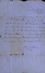
Letter - Correspondence, McGlone land, 2/12/1921 12:00:00 AM
... Letter about terms for a possible sale of land... for a possible sale of land the the corner of Whitehorse Road... Mitcham melbourne Letter about terms for a possible sale of land ...Letter from T.R.B. Morton & Son to W.J. McGlone.Letter from T.R.B. Morton & Son to W.J. McGlone about terms for a possible sale of land the the corner of Whitehorse Road and Elizabeth Street, Mitcham, 2 Dec 1921.Letter from T.R.B. Morton & Son to W.J. McGlone.mcglone, william j., t.r.b. morton & son, whitehorse road, mitcham, elizabeth street, mitcham -
 Port Fairy Historical Society Museum and Archives
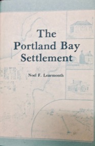
Book, The Historical Committee Of Portland, The Portland Bay Settlement, 1934
... including "List of Purchasers at original land sale", "First..., appendices including "List of Purchasers at original land sale ...Aboriginal resistance to settlement, Native Police Force, G.A. Robinsons proposal to re-settle Flinders Island people and extracts fom his 1841 expedition report. Contents I. The early navigators and explorers II. Sealers and whalers and tales of the sea III. The Hentys and Victoria's first permanent settlement IV. Early incidents and personalities V. Under government control Vi. Social life and activities VII. The story of the press VIII. Business, professions and industry IX. Hotels and roads X. Sport XI. Environs of Portland XII. Miscellaneous historical items.8vo; pp. x, 285; frontispiece, numerous b/w illustrations, plans and maps two of which are folding, index, appendices including "List of Purchasers at original land sale", "First Election List", "Subscription lists for both First Church of England and First Presbyterian Church", original blue cloth, title in gilt on spinenon-fictionAboriginal resistance to settlement, Native Police Force, G.A. Robinsons proposal to re-settle Flinders Island people and extracts fom his 1841 expedition report. Contents I. The early navigators and explorers II. Sealers and whalers and tales of the sea III. The Hentys and Victoria's first permanent settlement IV. Early incidents and personalities V. Under government control Vi. Social life and activities VII. The story of the press VIII. Business, professions and industry IX. Hotels and roads X. Sport XI. Environs of Portland XII. Miscellaneous historical items.robinson, george augustus, 1791-1866., government policy - initial period and protectionism - 1788-1850., government policy - state and territory - victoria., law enforcement - police - native police., race relations - violent - massacres, murders, poisonings etc. - to 1900., sport., pioneers -- victoria -- portland., portland (w vic sj54-11), portland (vic.) -- history., book -
 Bacchus Marsh & District Historical Society
Map, Plan of Land at Bacchus Marsh, the Property of James Young, 1868
... Land. The land for sale was described as, 'unsurpassed...A single page paper map showing 38 blocks of land for sale... Land. The land for sale was described as, 'unsurpassed ...James Young was a prominent businessman, land owner and public figure in the early colonial period of Bacchus Marsh. In February 1868 he offered for sale through the agent W. Anderson 38 blocks of land which ran from the Lerderderg RIver westwards beyond Gisborne Road in the vicinity of the present day Masons Land. The land for sale was described as, 'unsurpassed Agricultural Land, in the immediate vicinity of Bacchus Marsh, varying in size from 2 to 12 acres each'. The sale notice in the Bacchus Marsh Express of 1st February 1868 page 2, also noted that, ' Plans can be seen at Mr. Young's Border Mills Store, and at the Border Inn'. One of the largest and most important land sales in the early colonial period of Bacchus Marsh.A single page paper map showing 38 blocks of land for sale in 1868 in the vicinity of Masons Lane Bacchus Marsh. Scale 11 chains to 1 inch. The map is pasted into a bound volume containing 76 maps or plans in total. High resolution digital image stored on BMDHS computer network. land sales bacchus marsh, bacchus marsh victoria maps, james young 1816-1871, masons lane bacchus marsh land sales -
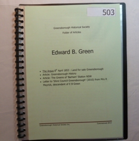 Greensborough Historical Society
Folder, Edward B. Green, 1853o
... Contents: Land sale for Greensborough (The Argus 1853... Plenty Lower Plenty melbourne Contents: Land sale ...Contents: Land sale for Greensborough (The Argus 1853); Article: Greensborough history; Article: The Greens of Barham Station NSW; letter to Shire council from descendant of E B Green. History of the origins of Edward Bernard Green after whom Greensborough was named.20-page plastic binder, spiral bound, clear cover. Contains documents relating to Edward B. Green and family.Collected by Greensborough Historical Society. Folder commenced 2012.greensborough, edward bernard green -
 Bacchus Marsh & District Historical Society
Map, Plan of the second portion of the property of Messers Atkins and Clarke situate at Bacchus Marsh 1856
... This plan of land allotments for sale indicates part... for sale. The subdivided land shown was owned by John Aitkins...This plan of land allotments for sale indicates part ...This plan of land allotments for sale indicates part of the property once owned by the Bacchus family in and around the township area of Bacchus Marsh. The Bacchus family sold their property in Bacchus Marsh to John Aitkins and Robert Nalder Clarke in March 1851. Aitkins and Clarke kept the property for a number of years until April 1856 when these allotments were put up for sale.This is a very early land sales plan for agricultural land close to the township of Bacchus Marsh. It therefore provides some clues as to how the early urban development of the township and agricultural development of the nearby area took place. Upon seeing the map in 1911 Bacchus Marsh Express newspaper editor Christopher Crisp wrote "The sale appears to have created the present township, which had a nucleus in earlier times further east", Express, 30 September, 1911, page 3.A single page paper plan showing allotments of land for sale. The subdivided land shown was owned by John Aitkins and Robert Nalder Clarke, but previously owned by the Bacchus Family and was in and around their Manor House (Mansion) property in Bacchus Marsh. This plan shows allotments in the second portion of land to be sold which was located east of the Manor House on the eastern side of the Lerderderg River. The land for sale was made up of 15 allotments. The plan is pasted into a bound volume containing 76 maps or plans in total. BMDHS Loc: AR/B12/S4 Bacchus Marsh Township and Nearby Districts Maps Volume In-house Digital copies: BMDHS, Computer Network: Maps\Bacchus Marsh Township and Nearby Districts Maps Volumebacchus marsh victoria maps, bacchus family, land sales, manor house bacchus marsh -
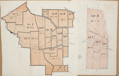
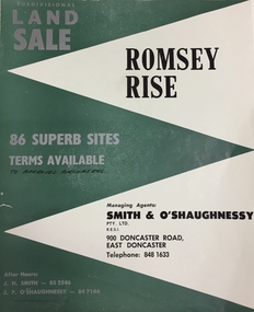 Kew Historical Society Inc
Plan - Subdivision Plan, Romsey Rise, Doncaster East
... Real estate brochure for a land sale of 86 sites in East... estate brochure for a land sale of 86 sites in East Doncaster ...Real estate brochure for a land sale of 86 sites in East Doncaster. Roads identified in the plan include: George Street, Dennert Street, Worthing Avenue, Sandhurst Street, Belinda Crescent, and Romsey Rise.Historic subdivision plan of a Doncaster East EstateFour page colour real estate brochure including on page 2 a subdivision plan for the Romsey Rise estate in East Doncaster. This record also includes a separate price list for the lots.real estate plans, subdivision plans - doncaster east, romsey rise estate - doncaster east (vic) -
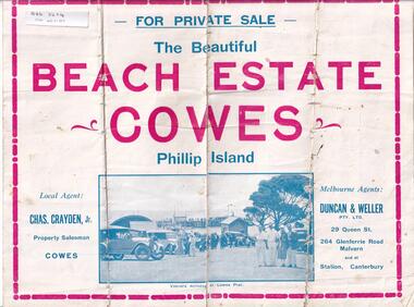 Phillip Island and District Historical Society Inc.
Brochure, Beach Estate Cowes, c 1940's
... Advertising Land for Sale in Cowes, Phillip Island...-island-and-the-bass-coast Advertising Land for Sale in Cowes ...Advertising Land for Sale in Cowes, Phillip IslandFour page colour Brochure advertising land in Devon Avenue and Cornwall Avenue, Cowes, For Sale. Illustrations of Cowes Pier, The Beach at Cowes and motoring on the Island.Four pages of Real Estate lingo!! Agents - Chas Grayden Jnr, Cowes and Duncan & Weller, Malvernreal estate, cowes phillip island, charles grayden jnr., cowes, duncan & weller, malvern & canterbury -
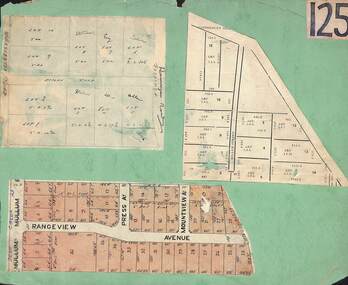 Ringwood and District Historical Society
Card, Collage of Residential Subdivision Map Clippings - Ringwood, Victoria - (Undated)
... Heathmont. Clipping from a land sale brochure with street names... Heathmont. Clipping from a land sale brochure with street names ...Three maps mounted on green cardboard - Hand-drawn map of residential allotments off Warrandyte Road in Milne Road and Berringa Road Park Orchards. Map with acres roods and perches measurements of allotments in Canterbury Road and Miller Street Heathmont. Clipping from a land sale brochure with street names not existing together in the area - Rangeview Avenue, Press Avenue and Mountview Avenue. -
 Bacchus Marsh & District Historical Society
Map, Plan of the property of Messers Atkins and Clarke to be sold at the Mansion, Bacchus Marsh 19th April 1856. Copy 1
... This plan of land allotments for sale indicates... for sale. The subdivided land shown was owned by John Atkins...This plan of land allotments for sale indicates ...This plan of land allotments for sale indicates the property once owned by the Bacchus family in and around the township area of Bacchus Marsh. The Bacchus family sold their property in Bacchus Marsh to John Atkins and Robert Nalder Clarke in March 1851. Atkins and Clarke kept the property for a number of years until April 1856 when these allotments were put up for sale.This plan is almost identical to another copy held by the Bacchus Marsh and District Historical Society, VC Record 452, BMDHS collection). This plan, VC Record 707 Copy 1, contains a little more detail overall than VC Record 452 Copy 2, such as who did the survey work for the plan (R.C. Bagot) and who the selling agents were, (W.M. Tennent), and on the right side of the plan near the Lerderderg River is indicated the general area for a second parcel of land from this sale which is to be sold. There is also a compass illustration indicating north and south compass points.This is a very early land sales plan for the township of Bacchus Marsh and it therefore provides some clues as to how the early urban development of the township took place. Upon seeing the map in 1911 Bacchus Marsh Express newspaper editor Christopher Crisp wrote "The sale appears to have created the present township, which had a nucleus in earlier times further east", Express, 30 September, 1911, page 3.A single page paper plan showing allotments of land for sale. The subdivided land shown was owned by John Atkins and Robert Nalder Clarke, but previously owned by the Bacchus Family and was in and around their Manor House (Mansion) property in Bacchus Marsh.There are 5 portions of land further divided into numerous small portions. The land for sale is bounded by the present day streets of Main Street, Young Street, McFarland Street, Morton Streets, Crook Street, and part of the eastern section extends to the Lerderderg River. Scale: 8 chains to 1 inch The plan is pasted into a bound volume containing 76 maps or plans in total. BMDHS Loc: AR/B12/S4 Bacchus Marsh Township and Nearby Districts Maps Volume In-house Digital copies: BMDHS, Computer Network: Maps\Bacchus Marsh Township and Nearby Districts Maps VolumeHeading: Plan of the first portion of land. The property of Messers Atkins and Clarke situate at Bacchus Marsh. To be sold by W.M. Tennent & Co. at the Mansion on the Ground on Saturday the 19th April 1856. Below heading: Jas Ferguson, Lithographer On upper right side: Subdivided by R.C. Bagot London and Liverpool Chambers, Melbourne. 'Thos Taubman'. Post Office Stamp: BACCHUS MARSH VICTORIA MY 6, 63bacchus marsh victoria maps, bacchus family, land sales, manor house bacchus marsh -
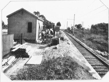 Ringwood and District Historical Society
Photograph, Constructing Ringwood East railway station - 1925
... plan land sale Ringwood East Railway Station Estate 1925?"... plan land sale Ringwood East Railway Station Estate 1925 ...Black and white photographs - 2 copies, same sizeTyped below one photograph, "Constructing Ringwood East railway station - 1925". Backing sheet of other photograph reads, "Ringwood East railway station - Higher than Croydon or Ringwood. Photo taken from Ringwood East railway station. Sub-division plan land sale Ringwood East Railway Station Estate 1925?" -
Southern Sherbrooke Historical Society Inc.
Map - photocopy, Woodcock & McCormack, civil engineers & architects & surveyors, The Major Estate, Belgrave
... A photocopy taken from the original land sale map provided... A photocopy taken from the original land sale map provided ...A photocopy taken from the original land sale map provided to the society through Karel Coxell of Stockdale & Leggo. The original maps are stored in large bound account books and were originally the propert of McNally Real Estate. The books are held (in 22 A3 sheets. Shows The Serpentine between Government Rd (now Sandells Rd) and Government Rd(now Terrys Ave), Belgrave. Arrows to Belgrave, Sherbrooke Falls, Main Rd and store.land sales, advertisement, real estate subdivision, t. mahoney -
Southern Sherbrooke Historical Society Inc.
Map - photocopy
... A photocopy taken from the original land sale map provided... A photocopy taken from the original land sale map provided ...A photocopy taken from the original land sale map provided to the society through Karel Coxell of Stockdale & Leggo. The original maps are stored in large bound account books and were originally the propert of McNally Real Estate. The books are held (in 2A3 photocopy of plan of survey of part of Crown Allotments 20 & 21, section C, parish of Narre Worran, County of Mornington. Clements Ave and environs in Belgrave Heights"Villette Estate" in top LH corner, "Locality Plan" in bottom LH corner, "Not in sale" written on one block and crossed out. All handwritten in pencil on original. "Colby Drive " and "Verona Street" added in pencil to copy.land sales, advertisements, subdivision -
 Bacchus Marsh & District Historical Society
Map, Glenvale Estate and Glenmore Estate Land Sales 1909
... to the sale of land from the Glenmore Estate property. The Glenmore...' at the top of the map shows 4 lots of land for sale. Both parcels... to the sale of land from the Glenmore Estate property. The Glenmore ...The two land auction plans shown in this record relate to the sale of land from the Glenmore Estate property. The Glenmore property was established by C.J. (Charles James) Griffith and James Moore around 1840. Moore sold his interest to Moelesworth Greene in 1848. Greene was the nephew of the other owner Charles Griffith who died in 1863. From around the 1870s onwards parts of the Estate were subdivided and put up for sale or lease. In subsequent decades more changes in ownership occurred. These two plans document another major sale of the land from the original Glenmore Estate including part of the estate which had become used for dairy farming and was at that time known as the Glenvale Estate. Two single page maps pasted together on a single page of a bound volume of maps. One map shows 15 separate lots of land for sale. The other map which has the words 'Glenvale Estate' at the top of the map shows 4 lots of land for sale. Both parcels of land were originally part of the Glenmore Estate a pastoral holding belonging to C.J. Griffith and James Moore which the began in the Rowsley area south west of Bacchus Marsh in the 1840s. The maps are pasted into a bound volume containing 76 maps or plans in total. High resolution digital image stored on BMDHS computer network. bacchus marsh victoria maps, glenvale estate property, glenvale estate land sales, glenmore estate, glenmore station -
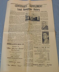 Bendigo Historical Society Inc.
Newspaper - McIvor Times Supplement
... months 40,000 men had rushed to the scene. The first land sale... had rushed to the scene. The first land sale occurred ...The "McIvor Times" first published 29 issues in 1863. In 1852 gold was discovered along the McIvor Creek and within six months 40,000 men had rushed to the scene. The first land sale occurred in January 1854, and the town was named Heathcote. By 1854 the majority of miners had moved on.A sixteen pages supplement to the McIvor Times. Published Wednesday, April 3, 1963, titled Centenary Supplement local newspaper history. Aileen and John Ellison Collection.local newspaper, mcivor times, heathcote -
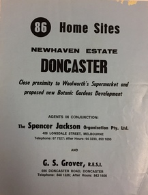 Kew Historical Society Inc
Plan - Subdivision Plan, New Haven Estate, Doncaster
... on the reverse.The land for sale would appear to be in George Street... land for sale would appear to be in George Street New Haven ...Subdivision of 86 home sites in Doncaster.Undated subdivision plan for 86 home sites in the New Haven Estate in Doncaster. The 2-sided plan has a locality plan on the reverse.The land for sale would appear to be in George StreetNilnew haven estate - doncaster (vic), subdivision plans - doncaster (vic) -
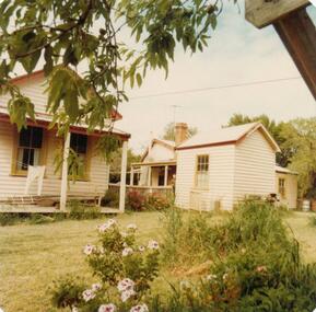 Phillip Island and District Historical Society Inc.
Photograph, 1978/9
... arrived on Phillip Island in 1868 when the first land sale took... when the first land sale took place. Charlie, William's son ...The house was built by William Richardson who went to live at Rhyll in 1876. His father, Joseph, owned the land. Joseph had arrived on Phillip Island in 1868 when the first land sale took place. Charlie, William's son, grew up in the house with his parents, brothers and sisters.Coloured photograph showing the kitchen at William Richardson's house in Rhyll.local history, photographs, buildings - historical, housing, coloured photograph, john cook, phillip island, charlie richardson -
 Ringwood and District Historical Society
Map, Plan of Subdivision - State School Estate, Ringwood East, Victoria - (Undated, circa 1920s)
... Map of land for sale attached to green cardboard backing... railway station which opened in 1925. Map of land for sale ...Map of land for sale attached to green cardboard backing with handwritten notations showing numbered allotments on Dublin Road, Holland Road, King Street, Charles Street and Purser Avenue, Ringwood East.Locality plan includes reference to proposed Ringwood East railway station which opened in 1925. -
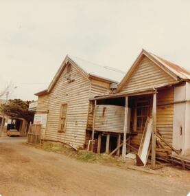 Phillip Island and District Historical Society Inc.
Photograph, 1978/79
... January 1869 at the first land sale in Cowes, John West...-island-and-the-bass-coast January 1869 at the first land sale ...January 1869 at the first land sale in Cowes, John West bought Lot 1 for £45 . In the 1870's he built the first Chicory Kiln on Phillip Island. With his brother, Solomon, he started the General Store next to the Chicory Kiln in Thompson Avenue. Over the years the original building was extended and altered.Photograph of remains of West's store, Cowes. Timber building with corrugated roofing. Old iron water tank in front of building.local history, photographs, buildings, historic, buildings - historical, sepia photograph, john cook, phillip island, west's general store