Showing 1290 items
matching lands
-
 Federation University Historical Collection
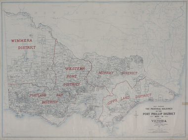
Plan, Map Showing the Pastoral Holdings of the Port Phillip District 1835-1851 Now Victoria, 1932, 1932
Another name for Pastoral Holdings is squatting runs. Information on Alfred Stephen Kenyon of the Historical Society of Victoria can be found at http://adb.anu.edu.au/biography/kenyon-alfred-stephen-6936/text12035 Map of Victoria showing the boundaries of the Port Phillip District (Victoria) pastoral boundaries. pastoral holdings, squatters, squatting, victoria, land, crown lands, a.s. kenyon, alfred stephen kenyon -
 Federation University Historical Collection
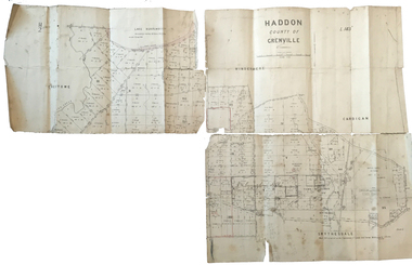
Plan, Haddon, County of Grenville, 1932, 13/04/1932
The Haddon Parish Plan shows crown parcels government roads, Crown Reserves, Railway. Scale 40 chains to 1" (1:31, 680) WGS 84 Centroid Lat: 37 degrees 34' 00" S Long: 148 degrees 40' 20" E N.S. 9.3km E.W.: 16.1kmhaddon, grenville, cardigan, water supply reserve, nentingbook pre-emptive right, a. mclachlan, lake burrumbeet, e.a. wynne, p. russell, b. hepburn, benjamin hepburn, nentingbool, t.c. wilson, j. amoy, william collard smith, james roach, j. mitchell -
 Federation University Historical Collection
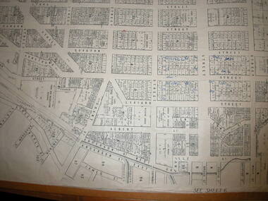
Plan, Ballaarat City Parish Plans, 1931, 09/03/1931
Large Scale plans showing streets, allotments, dimensions, crown grantees, dates granted, etc Sheet 2: Sturt Street, Rubicon Street, Pryor Street, Humffray Street, Sebastopol Street, Armstrong Street South, Fraser Street, Hickman Street ballarat, ballaarat, plans, city of ballarat -
 Federation University Historical Collection
Map, Topographical Map Creswick A & B
Printed map on papercreswick, clunes, lexton, waubra, smeaton -
 Federation University Historical Collection
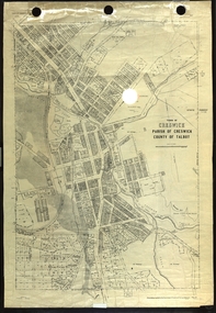
Plan, Creswick, Parish of Creswick, County of Talbot, 1928, 1928
Parish Plan of Creswick showing Slaty Creek, Old Gold Workings, Police Reserve, Railway Station, Public Gardens, Sawpit Gully, Hospital Reserve, Nigh Soil Depot, Eureka Terracotta Tile COmpany, Creswick Creek, Forest COmmission, Roycroft's Racecreswick, eureka terracotta tile co, parish plan -
 Federation University Historical Collection
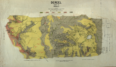
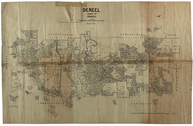
Map, Dereel, County of Grenville, 1890, 1890
Dereel is in western Victoria.Geological map of Dereel in the County of Grenville featuing six colours (predominantly grey and yellow). WGS 84 Centroid Lat: 37 degrees 48 feet 50 inches S Long:143 degrees 42 feet 10 inches S N-S: 6.4 km E-W: 15.2 km dereel, ferdinand krause, crown lands department, plan -
 Federation University Historical Collection
Plan, Dereel Parish Plan, 1928, 16/07/1928
Parish Plan of Dereel showing crown allotments, dimensions, crown grantees, dates of grant. Scale 1:31,680 WGS 84 Centroid 37 degrees 48 feet 33 inches S 143 degrees 41 feet 46 inches S NS: 6.3km EW: 15.2kmdereel, parish plan, p. mclachlan, rifle range, j. bower, dereel lagoon, t. mellington, j. mcdonald -
 Federation University Historical Collection
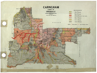
Plan, Carngham, County of Grenville
A plan of Carngham, Victoria.snake valley, timber reserve, poverty point, recreation reserve, carngham, county of ripon, county of grenville, plan -
 Federation University Historical Collection
Plan, Haddon County of Grenville, 1887, 1887
Parish Plan of Haddon showing the township of Haddon, Cardigan and Haddon State Forest, Lake Burrumbeet and Nentingbook Pre-emptive Right. Names on the allotments include H. Cuthbert, B. Hepburn, T.W. Lloyd, J. Palmer, E.A. Wynne, William Collard Smith, A. Porteous, P. Russell, J. Mitchell, G. Renniehandwritten 'J. H. Cunningham Applic'haddon, cardigan, haddon state forest, lake burrumbeet, nentingbook pre-emptive right, h. cuthbert, b. hepburn, t.w. lloyd, j. palmer, e.a. wynne, william collard smith, a. porteous, p. russell, j. mitchell, g. rennie, j. noone, department of lands and survey -
 Federation University Historical Collection
Plan, Parish of Dowling Forest, County of Ripon and Grenville, 19
Scale [1:31 680]. 40 chains to 1 in.Geological map on a cadastral base, showing the occurence of reefs, and alluvial deposits. Relief shown by contours.dowling forest, wyndholm, wyndholm pre-emptive right, miners rest, ballarat racecourse, winter's swamp, police reserve, miner's rest, winters swamp, geology -
 Federation University Historical Collection
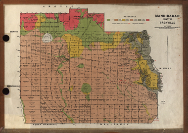
Plan, Mannibadar Geological plan
Coloured plan of Mannibadar, County of Grenville.mannibadar, pitfield, mount bute, emu hills, woady yalouk river, geology, plan -
 Federation University Historical Collection
Photograph - coloured, Department of Lands and Survey, Portion of Victoria showing auriferous areas and mineral localities, 1935, 1935
Map included with book "Victoria: Gold and Minerals" issued by Mines Department Victoria, 1935Fold out coloured mapYellow mark indicating depositsvictoria, auriferous areas, mineral localities, department of mines, tin, antimony, copper, silver lead, tungsten, manganese, platinum, iron -
Port Melbourne Historical & Preservation Society
Map - "The Township of Sandridge", Public Lands Office, 1859
Photocopy 1859 map of township of Sandridgelocal government - municipal district of sandridge, frank callaghan -
Port Melbourne Historical & Preservation Society
Map - Melbourne and suburbs, Department of Lands and Survey, 1 May 1934
Large printed map of Melbourne and suburbs 1936 showing historic sightsmelbourne, south melbourne, transport - tramways, transport - railways -
Port Melbourne Historical & Preservation Society
Map - City of Port Melbourne, Department of Lands and Survey, 29 Nov 1938
Printed map of City of Port Melbourne - Fishermens Bend area and down to Williamstown Road (Kitchens etc). 1938Red pencil marks through existing Lorimer St (refer 306)built environment - industrial, health - general health, fishermans bend, j kitchen & sons pty ltd -
 Victorian Aboriginal Corporation for Languages
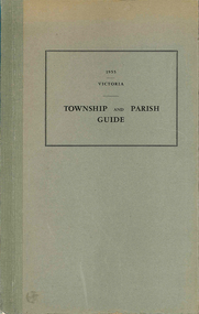
Book, Department of Crown Lands and Survey Victoria, Township and parish guide : Victoria, 1955
A alphabetical list of townships proclaimed under the Land Acts of Victoria. Shows the parish, land district and the municipality in which each is situated, and the particulars of Gazettal of Proclamation.victorian geographical names, victorian administration -
 Victorian Aboriginal Corporation for Languages
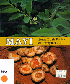
Book, Mayi : some bush fruits of Dampierland, 1987
Rich cultural knowledge and language words presented in botanical reference style. Includes short personal story by Karrmaka (Elsie White).Colour photographs, b&w drawingsyawuru, karajarri, nyul nyul, nyangamarta, bardi -
Lakes Entrance Historical Society
Book, A Study of Land in the Catchment of the Gippslnd Lakes Vol 1, 1988
108 printed pages in report, wire spiral boundBlue cardboard cover with title printed in golddocuments, reports -
 Ballarat Tramway Museum
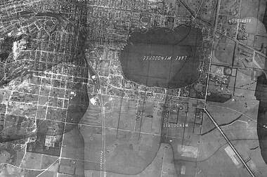
Photograph - Black & White Photograph/s, State of Victoria Lands Department, c1940
Yields information about the development and Lake Wendouree from an aerial photograph c1940.Black and white photograph of an aerial view of the Lake Wendouree and the northern part of Ballarat c1940. Shows the photograph join lines, has names of suburbs, Railway lines. Purchased from rusty via Ebay 16/5/2019.trams, tramways, lake wendouree, ballarat, aerial views -
 Bayside Gallery - Bayside City Council Art & Heritage Collection
Map, Department of Crown Lands and Survey, Moorabbin, County of Bourke, c. 1918
The cadastral map of the Parish of Moorabbin in Victoria (L.6104) shows parish boundaries and land ownership c. 1918 when Sandringham was a Borough.moorabbin, county of bourke, map, plan, land subdivision, land titles, foreshores, sndringham, hampton, beaumaris, highett, cheltenham, department of lands and survey, land owners, cartographic material, borough of sandringham, brighton -
 Bendigo Historical Society Inc.
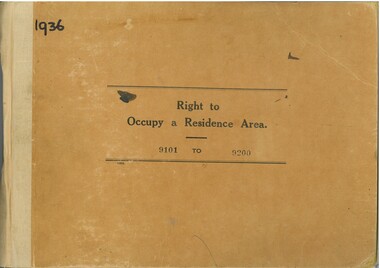
Administrative record - Right to Occupy Certificates, 1936
Twelve books containing stubs of Right to Occupy Certificates for 1936. Includes name and address of person receiving the Right to Occupy certificate and the description of the land including allotment, Section, City, Town, Borough or Township and Parish name. List of record Numbers in Box 906 Some items have pencil and pen marks and ink stains.right to occupy, central victoria -
University of Melbourne, Burnley Campus Archives
Document - Conference Papers, Conservation Forests & Lands, Second Landcare Community Conference, 14-15.07.1989
conference, landcare, conservation, community -
 Federation University Historical Collection
Map - Geological Survey, J. Phillips, Geological Survey of Victoria - Ballarat, 1857, 10/1858
Geological map of the Ballarat District featuring four colours.ballarat, geological, geology, geological plan, main road, camp, golden point, pennyweight hill, clayton hill, ballaarat cemetery, bakery hill, specimen hill, soldiers hill, nightingale lead, native youth black hill flat, white flat, mining, mines, eureka lead, old post office hill -
 Melbourne Tram Museum
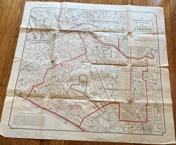
Map, Department of Lands and Survey Melbourne, Commonwealth Electoral Division of Fawkner, 1-10-1912
Shows a detailed street plan of South Melbourne, Albert Park, Prahran, South Yarra and parts of Melbourne in 1912. Used to mark the electoral boundaries of the Commonwealth Electoral Division of Fawkner. Shows all the then cable tram lines, rail lines and the electric line of the PMTT along with docks, gardens and significant buildings.Gives details of the Fawkner Electoral district in 1912.Folded sheet - Map - Commonwealth Electoral Division of Fawkner - two colours showing the subdivisions and polling placesmelbourne, fawkner, tram lines, cable trams, maps, electoral maps, south melbourne, albert park, prahran -
Lakes Entrance Historical Society
Book, Department of Conservation Forests and Lands, Management Alternatives for Gippsland Lakes 1989, 1989
Provides information and inviting public comment and discussion on the management of the Gippsland Lakes Victoria.wetlands, recreation, waterways -
Stawell Historical Society Inc
Map, Department of Lands and Survey Melbourne, Swinton Estate. Parish of Riachella. County of Borong, 3-08-1921
Shows part of Warranook TrainwayA1 Printed Map With Cloth Backing. Annotations in Red Ink W.J. Butson 3-8-21farming -
Clunes Museum
Plan - TITLE PLAN, DEPARTMENT OF LANDS AND SURVEY, PARISH OF CLUNES - COUNTY OF TALBOT, 1959
.1 1 PAGE PLAN LISTING TITLES FOR THE PARISH OF CLUNES 1959 (3 COPIES) SHEET 1 SCALE: 1 INCH TO 40 CHAINS .2 1 PAGE PLAN LISTING TITLES FOR THE PARISH OF CLUNES 1959 SHEET 2 SCALE: 1 INCH TO 2 CHAINSBY AUTHORITY A C BROOKS GOVT. PRINTER, MELBOURNE PARISH OF CLUNESparish of clunes, title plans clunes -
Clunes Museum
Map, DEPARTMENT OF LANDS AND SURVEY, TOWNSHIP OF CLUNES, PARISH OF CLUNES, COUNTY OF TALBOT, 1950
MAP OF CLUNES ON PAPER SHOWING HOTELS AND TOWNSHIP HIGHLIGHTS COMPLETE WITH LEGEND. OVERWRITTEN NOTATIONS IN RED AND BLUE INKPRICE 2stownship of clunes 1950, hotels of clunes -
Clunes Museum
Map, A.C. BROOKS GOVERNMENT PRINTER MELBOURNE, EGLINTON COUNTY OF TALBOT, 1965
MAP OF EGLINTONMAP OF EGLINTON, COUNTY OF TALBOT PRINTED ON CANVAS WITH PLASTIC TAB FOR HANGING. MAP SHOWS TOWN ALLOTMENTSADMINISTRATIVE STAMP ON BOTTOM LEFT AND ON THE BACK OF THE MAP ANOTHER STAMP - NORTHERN DIVISION (299) FORESTS COMMISSION BENDIGOeglinton, historical map -
Clunes Museum
Map, DEPARTMENT OF LANDS AND SURVEY
MAP OF ALLOTMENTS IN CLUNESlocal history, documents, map, township, clunes