Showing 298 items matching "mining survey"
-
 Stawell Historical Society Inc
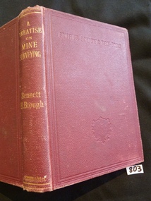
Book, Bennett H Brough, A Treatise on Mine Surveying, 1896
William W Telfordstawell education mining -
 Stawell Historical Society Inc
Map, Geological Survey Office, Sloanes & Scotchmans united Mine, December 1916
... grampians mining gold map Geological Survey Office Ballarat December ...Sloane & Scotchman's Geological Survey Map 1916 Showing Underground DrivesGeological Survey Office Ballarat December 1916 mining, gold, map -
Stawell Historical Society Inc
Map, Charles C Reilly, Oriental & North Cross Reef Mine showing underground drives, 3/5/1900
Underground Survey of Mines Stawell c1900Charles C Reilley 3.5.00 mining, gold, map -
Stawell Historical Society Inc
Map, Gold Mines of Australia, Gold Mines of Australia underground workings. Newington Rd Darlington Rd Area 1950, 1950
Plans Showing Surveys & Drilling Stawell InvestmentGold Mines of Australia Stawell Investment 2003 mining, gold, map -
Koorie Heritage Trust
Book, Broome, Richard, Aboriginal Australians. Black Responses to white Dominance 1788-1994. (Second Edition), 1994
Surveys traditional life and values, confrontations with the British; violent conflicts with settlers, native police throughout the country; attacks on Aboriginal initiative at Coranderrk, Cumeroogunja and other settlements; racial legislation, missionary attitudes; cattle industry, mining; discrimination; growth of Aboriginal rights movement, Aboriginal organizations, land rights.4-275 P.; plates; ill,; appendices; notes; bib.; index; 22 cm.Surveys traditional life and values, confrontations with the British; violent conflicts with settlers, native police throughout the country; attacks on Aboriginal initiative at Coranderrk, Cumeroogunja and other settlements; racial legislation, missionary attitudes; cattle industry, mining; discrimination; growth of Aboriginal rights movement, Aboriginal organizations, land rights.aboriginal australians -- social conditions. | race discrimination -- australia. | australia -- race relations. | economic sectors - agriculture and horticulture - pastoral industry - beef cattle | religions - christianity - missions | settlement and contacts - 20th century | enterprises - pastoral industry | government policy - assimilation | government policy - initial period and protectionism | government policy - integration | government policy - state and territory - new south wales | government policy - state and territory - victoria | law - land | land rights - mining industry | land rights - pastoral industry | socioeconomic conditions - living conditions | occupations - pastoral industry workers | law enforcement - police - native police | law enforcement - police conduct and attitudes | politics and government - political action - land rights | race relations - violent - massacres, murders, poisonings etc. - to 1900 | race relations - racism - stereotyping | -
 Rutherglen Historical Society
Map, 1908
This is a map produced as part of a book entitled.. It is also stamped on the back in blue ink with an oval ring and the words North of England Institute. Newcastle. Mining & Meterolgical Faculty. Purchased on 23rd July 2017 by the Society after research by member Simon Killeen. Mining map of one of the first mines in Rutherglen area ( Chiltern West)Cream paper, black printing, rectangle with a drawingGeographical Survey of Victoria, Memoir, No6. Plate XX Plan of Underground Workings CHILTERN VALLEY CONSOLS MINE, RUTHERGLEN, PARISH OF CHILTERN WESTgold, rutherglen, mining, chiltern, underground mine map, geological survey, reef drives -
 Ballarat Heritage Services
Photograph - Photograph - Colour, Clare Gervasoni, Tarilta, 2017, 16/07/2017
Tarilta is a rural locality and former gold-mining town 12 km south of Castlemaine, 4 km north-west of Guildford and 3 km north-east of Vaughan. The last gold mining activity took place around the 1880s. It was originally Kangaroo Flat, being located where the Kangaroo Creek enters the Loddon River. It was surveyed and named in 1864. Gold was discovered at Tarilta in 1853. The Tarilta School was opened in 1860 in a Wesleyan chapel, and closed i n1925. In 1864 a township was surveyed and named Tarilta, the word being derived from an Aboriginal expression thought to mean kangaroo. In 1865 Bailliere’s Victorian gazetteer described Tarilta as being an alluvial and quartz gold-mining town with three quartz-crushing mills, three horse-puddling machines and two hotels. The elevated nature of the land around Tarilta made it accessible only by horse and dray, or on horseback. Colour photograph of Tarilta in Central Victoria. tarilta, central victoria, landcape -
 Ballarat Tramway Museum
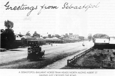
Book, E.D. Jenkins and Lloyd Jenkins, "Sebastopol Victoria - A Historical Survey of Early Sebastopol - 1864- 1964", 1989
Book - 92 pages plus card covers, a historical survey of the Sebastopol district. Originally written by E.D. Jenkins for the Borough of Sebastopol's centenary in 1964, reprinted with additional text by Lloyd Jenkins to recognise the 125th anniversary of the Borough covering the years 1965 to 1989. Book covers mining history, churches, the Borough Council, early days of the district and various points, eg cabmen, horse trams and electric trams, schools, the Mechanics Institute, various clubs, fire brigade, hotels, industries, and programme of events to celebrate the centenary. The second part of the book, covering the period is laid out in a chronological order with forward by Cr. Donald, the Mayor with many photographs. Centre page has a large map of the district showing the many mines, leads, roads and other historic locations. Tramway photos are horse tram No. 7, ESCo 17 at depot (all on file) and a photo showing a horse tram heading north along Albert St. with the shopping centre in the background - see image. Photo taken just after the tram has crossed the roadway. Copy of the horse tram heading north along Albert St. made Oct. 2001 for the "gold, Gold GOLD" temporary exhibition - colour laser print onto card, with Velcro dots on rear. Stored in box D1 (Display Box) 02/2003. See Reg Item 3883 for another print of this photograph.On page 3 in black ink "Ballarat Tramway Museum Inc. With compliments, D.L. Jenkins 14/4/1999"trams, tramways, sebastopol, local history, public transport, mining, horse trams, esco -
 Bendigo Historical Society Inc.
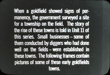
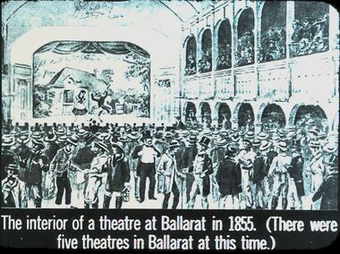
Slide - DIGGERS & MINING: THE DIGGINGS - THE DIGGERS
Diggers & Mining: The Digging - The Diggers. Slide; When a Gold field shows signs of permanency, the Government surveyed a site for a township on the field. The story of the rise of these towns is told in Unit II of this series. Smalll businesses - some of them conducted by diggers who had done well on the fields - were established in these towns. The following frames contain pictures of some of these early goldfields towns. Black and white side. Markings: 40 994.LIF:6. Used as a teaching aid.hanimounteducation, tertiary, goldfields -
 Bendigo Historical Society Inc.
Slide - DIGGERS & MINING: THE DIGGINGS - THE DIGGERS
Diggers & Mining: The Digging - The Diggers. Slide reads; A correspondent of the Melbourne Morning Herald, surveying the diggings at Castlemaine when the noise had died down and the fires had burnt out, described the seen as follows;. . . Black and white side. Markings: 37 994.LIF:6. Used as a teaching aid.hanimounteducation, tertiary, goldfields -
 Bendigo Historical Society Inc.
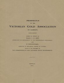
Document - MCCOLL, RANKIN AND STANISTREET COLLECTION: VICTORIAN GOLD ASSOCIATION, 1931
Prospectus of the Victorian Gold Association N.L. Based on a report by Messrs H. W. Gepp Consultant on Development to the Commonwealth Government and W. Baragwanath, Director of the Geological Survey of Victoria. Dated 1931 This company was formed to investigate the Deborah Mine, The Central Nell Gwynne Mine and the Monument Hill Mine. 12 pages including maps and Transverse Sections of the MinesThe Commonwealth and Victorian State Governments. E. Whitehead & Co., Pty., Ltd Printers 21 Equitale Place, Melbourne, C1.gold, mining, prospectus, bendigo, gold mines, victorian gold associatian, deborah mine, central nell gwynne mine, monument hill mine. -
Bendigo Historical Society Inc.
Document - Fortuna Bendigo, letter of re classification by the National Trust and History Brochure, 20/10/2008
The Fortuna Villa is an expansive Victorian mansion built entirely on the profits of Bendigo's lucrative gold reefs. Established by the wealthy Ballerstedt family in the 1860s, it was purchased and expanded in the 1870s by George Lansell, who was to become one of Australia's wealthiest men. Fortuna villa and gardens were once occupied and cared for by the Australia Army Survey Regiments since 1942 for over thirty years.Classification Report and Notes on the history of Fortuna from the National Trust to the Bendigo Council 20th October 2008; tourist brochure for Fortuna; it includes photographs and detailed history of George Lansell's involvement in the property and his mining history.history, national trust bendigo collection, bendigo, fortuna, george lansell, mining -
Bendigo Historical Society Inc.
Document - Golden City Implements Foundry, Ironbark, Bendigo, 1960-1980s
This foundry had been a landmark in Mt Korong Road for many years. It began with an Osborne and Mitchell. After 1914 when mining declined, it became the Golden City Implement boundary and the name can still be seen painted on on the façade which faces the intersection of Marong Road (Calder highway) and Eaglehawk Road. The interior is a mass of used and un-used machinery scattered amongst modern lathes and more modern apparatus. The yard was a fascinating graveyard of past times, with old mining and agricultural scrap everywhere mixed up with coke and slag from the smelting sheds at the rear. A feature of the foundry was the manufacturer of cast iron lace. National Trust Survey Data Sheet and article from the Bendigo Advertiser November 4th 1981. Osbornes Ironbark Foundryhistory, national trust bendigo collection, bendigo, foundary, iron bark bendigo -
 Bendigo Historical Society Inc.
Document - MCCOLL, RANKIN AND STANISTREET COLLECTION: SUNDRY REPORTS, 1930's
Manilla Folder containing reports from various mines in Bendigo and surrounding areas. 1. 4 page typewritten report on the Balaclava Hill Mine at Rushworth and some newspaper clippings about the mine with a plan of the underground workings; 2. Page from the Árgus' dated 2nd August 1900 featuring an article on the survey of the Garden line of Reefs; 3. 5 page report with maps on the Tooleen Gold Field; 4. Single page report about an unnamed mining area claimed to be on the southern end of the Deborah line of reef. (this could be the 'Three Jays' mine in Sedgwick. P. Wilkin); 5. Hand written report on the Coronation Mine, 2 miles east of Walhalla.; 6. Hand written report dated 1935, of the Queen Mary mine, St. Arnaud.; 7. 1932 report on the North Neangar lease.; 8 4 page report on the Kings Prize Gold Mining Syndicate.; 9. Description of the plant of the Marong Alluvial Company? Also a guide for marking out leases.; 10. Crushing details (1 page) from the 'Enterprise' Mine South of and adjacent to Perseverence.; 11. 1 page crushing details from Rowe Brothers, Mosquito Mine, Fryerstown.; 12 hand written report mentions Arthur Hatfield, Scarsdale.; 13. Map with lines of reef showing the position of the New Moon Consolidated and the New Moon United shafts.; 14, Large scale map from Harrison/Victoria street to Havilah Road showing the positions of the Carlisle, North Garden and Unity Shafts.gold mining, miners' safety cage, sundry reports, mining. bendigo, rushworth, balaclava hill, garden line of reef, toolleen, coronation mine, walhalla, queen mary mine, st. arnaud. north neangar, kings prize gold mining syndicate, marong, enterprise mine, perseverence, rowe brothers, mosquito mine, fryerstown, arthur hatfield, scarsdale, new moon consolidate, new moon united, carlisle, north garden, unity. -
Bendigo Historical Society Inc.
Photograph - Aerial shots of parts of Bendigo 1934, 1934
AERIAL SHOTS OF PARTS OF BENDIGO 1934 Catalogue No.10584 This document contains scans of a unique set of aerial photographs that were taken over the City of Bendigo on Friday 12th January 1934, at about midday. The photographs were commissioned by Bendigo Mines Limited during their exploration and mining program designed to revitalize the Bendigo Goldfield. The photographs were given to the Victorian Mines Department sometime in the 1950s. The photographs were taken at a relatively low level of about 4000 feet. This gives a very detailed picture of Bendigo as it was in the 1930s. The photos cover the City Centre and are mainly of the goldfields on the south side of the city; the extent of which covers approximately the four corners of Myers Flat, Maiden Gully, Mandurang and One Tree Hill. Streets, roads and places of interest have been identified as best as possible in December 2023. There are 44 maps, and each references the adjoining maps.Typed Notes with CD The CD is one of two and contains a set of 46 images: The folder named "High_Resolution_800dpi" contains the original digital files that were produced by scanning the photographic prints (About A3 size) at 800 dpi using a high quality, large pformat, roll scanner. These files may be too large for some computers. A second CD contains a direstory called "Low_Resolution_300dep" The images in the folder names "Low_Reolution_300dpr" have a lower resolution (300 dpi) and have been rotated 90 degrees clockwise so that the Northern margin of each image is a the top of the screen. Clive Willman Senior Geologist Geological Survey of Victoriahistory, bendigo, bendigo mines, bendigo maps, bendigo aerial photos -
 Bendigo Historical Society Inc.
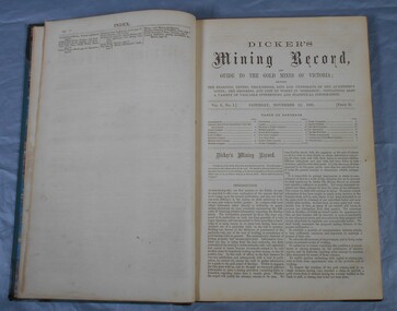
Journal - Dicker's Mining Journal 1862
Thomas Dicker, Rowan Street, Bendigo, published a monthly mining journal that included geological information, mine details and mining practises for particular mining districts. In 1868/9, Dicker moved to England to open the "Australian and London Mining Agency" with the goals of promoting investment in Victorian mines, entering Victorian mining shares on the London Stock market, and exploring the latest in mining technology that might be suitable for mining in Victoria.Dicker's Mining Record and guide to the gold mines of Victoria, showing the bearings, depths, thickness, dips and underlies of the auriferous lodes; the progress and cost of works in operation; containing also a variety of valuable interesting and statistical information. Published by the proprietor, Thomas Dicker, Rowan Street Sandhurst. A green with black spine hardcover book. Paper glued on the front with the title Dicker's Mining Journal 1862. On the spine in gold lettering Dicker's Mining Record Vol.1 1861-2. The book contains 12 issues of the Dicker's Mining Record, the first from Saturday, November 23, 1861: the last from October 24, 1862. Also, there are two pieces of paper inside front cover with writing in pencil; the first says: shaft originally No.3 shaft of the speedwell coy. in 1902 the North Normanby Coy. was formed and took over the shaft. A new winding engine was installed in 1909. 10 head battery 1905, extra 20 head in 1909. The second, also in pencil, reads: Dept. of Mines Geological survey No.4 Ballarat East goldfields - 1907 - Mr. Marbrey (?) 39 Shamrock St. Bendigo.Sticker on inside front page: Ballarat Historical Museum presented by Mr. W.H. Lewis Young Street. On second page in pencil: Mr. John N Bailey mining manager of John Woods mines Stawell, Sons of Freedom Beaufort (illegible). To Mr. John Bailey as a mark of esteem grom J. Logan.dicker's mining journal, 1862, mining -
Stawell Historical Society Inc
Archive, Geological Survey of Victoria 1903 Brown Cover, 1903
1903 Brown Coverstawell, mining -
 Federation University Art Collection
Sculpture - Mace, 'University Mace' by Trefor Prest, 1995
The University's mace was carried in procession for the first time during the Graduation ceremonies in May 1996. The mace was presented to the University by former Chief Commissioner of the Ballarat City Council, Vern Robson, at a ceremony on 02 February, following a national competition for its design, sponsored by the Council. (The Flag, Issue 2, July 1996) Nineteen artists responded to the competition which called for a design that would embody a distinctive Australian image reflecting the heritage of the city and in relationship with gold, an Aboriginal element and the history of the University. The winning entry, dominated by a poppet head, was submitted by Central Victorian artist/sculptor Trefor Prest, a sessional lecturer in sculpture at the University.(The Flag, Issue 2, July 1996) The Herald Sun of 03 February 1996 reported 'the new mace shows importance elements of Ballarat's heritage as well as the university's focus on the future. The artist emphasises the egalitarian nature of Australia as embodied in Ballarat's famous slice of history - the Eureka uprising. ... The mace has a poppet head at the top of the shaft - an unusual element for a mace - but it represents Ballarat's mining history and the University's evolution from the Ballarat School of Mines. An opening egg at the top stands for the nurturing of development and learning. The mace's straight shaft is depicted as the tree of knowledge and, incorporating a bark canoe scar, Ballarat's Aboriginal heritage. At the end of the shaft is a surveying device, which represents precision and accuracy ads embodied in the university's academic pursuits.' Bob Morrell of the University organised the national competition to design the mace and said 'It is in keeping with the university's logo, 'proudly flying the flag', which incorporates the Southern Cross.' This item is part of the Federation University Art Collection. The Art Collection features over 1000 works and was listed as a 'Ballarat Treasure' in 2007. Trefor Prest lectured in Sculpture at the University of Ballarat from 1995-1996.The mace symbolises the office of the Chancellor. The design of the mace is the outcome of a national competition and represents the cultural diversity of Australia. The poppet head on the top of the mace refers to gold mining, which underpinned the development of Ballarat. The protruding spikes recall the Eureka Stockade. The 'egg' shape enfolds and nurtures the development of knowledge and learning. The shaft with the three 'branches' represents the Tree of Knowledge, and includes a bark canoe scar which recognises the integration of black and white Australian traditions. The lower part of the shaft culminates in a device suggestive of scientific or surveying and measuring technology. This represents precision and accuracy embodied in the academic pursuits of Federation University Australia.art, artwork, trefor prest, prest, mace, federation university, university, eureka stockade, aborigines, scarred tree, mining, university mace, ballarat -
Tarnagulla History Archive
Set of Maps (Mining & Local Area), various
David Gordon Collection. A set of mining documents, maps and plans: 1. Dunolly Deep Leads - showing location and names of deep lead gold deposits in region around Dunolly including at Tarnagulla and Newbridge. Geological Survey of Victoria, Department of Minerals and Energy. Bulletin No. 62, Map No. 4 Dunolly (770 x 485 mm). 2. Poseidon Lead (Facsimile) 3. Nick O Time Lead (Facsimile) 4. Happy Go Lucky Mine prospectus and plan (colour copy) 5. Jones Creek GM Co. (Raven & Gourlay's) Waanyarra - Prospectus (colour copy) 6. Poseidon Area Plan (colour copy) and Poseidon Area map (B&W copy). 7. Cross-section diagram of Spread Eagle Reef 8. New Birthday Gold Mine - area map (colour copy) and mine cross-section ( (colour copy). 9. Cross section of Poverty Reef, by Department of Mines (B&W copy, 2 parts on A2 paper) 10. Time-Lease Graph for Watts Reef, Specimen Reef, Stony Reef, Poverty Reef (second page in detail), created by Eric WIlkinson for Ref Mining NL, 1995 11. 1859 Plan of the Gold Workings & Township of Sandy Creek, Shewing the Mining Leases, Extended Claims & Machinery by R.J. McMillan, Mining Surveyor (B&W copy) 12. Longitundinal and Transverse Vertical Sections of Poverty Reef, Sandy Creek 1859, by R.J. McMillan, Mining Surveyor (B&W copy) 13. Tarnagulla Locality Plan (B&W copy) 14. Universal Grid Reference Map (Topographic) for Laanecoorie North (2 copies) 15. Universal Grid Reference Map (Topographic) for Inglewood South 16. Poverty Reef, Plan showing shafts and early tenements, created by Eric WIlkinson for Ref Mining NL, 1995 17. Locality Map of mining leases in Tarnagulla 18. Plan and Elevation of part of Poverty Reef, Sandy Creek, showing the claims and positions of the shaft. by R.J. McMillan, Mining Surveyor (Facsimile, composed of taped together components) 19.Plan and Elevation of part of Poverty Reef, Sandy Creek, showing the claims and positions of the shaft. by R.J. McMillan, Mining Surveyor (Facsimile, composed of taped together components) -
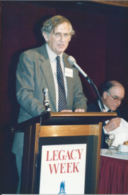 Melbourne Legacy
Photograph - Photo, Legacy Week 1988, 1988
A photo of Professor Geoffrey Blainey speaking at a the public launch of Legacy Week at the ANZ Pavilion at the Victorian Arts Centre. The date is 23 August 1988. Also a photo of John Lady and Terry Hawksley. The attached label says: " Melbourne Legacy held its first official public launch - a luncheon for Melbourne's leading business community at the ANZ Pavilion at the Victorian Arts Centre to highlight 'Legacy Week'. Professor Geoffrey Blainey, AO, addressed the guests and was joined by Legacy's 1988 personality, Australia's first under 4 minute miler, John Lady." They were in a folio of photos from 1988. (see also 001042 to 01049) From Wikipedia: "Geoffrey Norman Blainey AC, FAHA, FASSA (born 11 March 1930) is an Australian historian, academic, philanthropist and commentator with a wide international audience. Biographer Geoffrey Bolton argues that he has played multiple roles as an Australian historian: He first came to prominence in the 1950s as a pioneer in the neglected field of Australian business history....He produced during the 1960s and 1970s a number of surveys of Australian history in which explanation was organized around the exploration of the impact of the single factor (distance, mining, pre-settlement Aboriginal society).... Blainey next turned to the rhythms of global history in the industrial period.... Because of his authority as a historian, he was increasingly in demand as a commentator on Australian public affairs." From the name badges the attendees included: 1. Geoffrey Blainey. 2. John Landy and Terry Hawksley. 3. A girl and L/ Geoff Swan. 4. L/ David Millie and Jim Madden. 5. John ? and L/ Colin Bannister. 6. Patsy Adam-Smith (?) and artist Geoffrey Mallett. 7. ? and Jim Dickson. 8. Peter Prior and Abe Birmingham. 9. President Chas Wilks speaking. 10. President Chas Wilks and Rupe Thomas.A record of celebrities being involved in promoting Legacy Week in 1988 and an official launch at Victorian Arts Centre.Colour photo x 10 of public launch of Legacy Week in 1988.Yellow paper label explaining the event in black type.legacy week, legacy promotion, speakers -
Bendigo Historical Society Inc.
Map - STRUGNELL COLLECTION: BENDIGO GOLD FIELD GEOLOGICAL SURVEY, 1936
BHS CollectionBendigo Goldfieds Geological Survey. Prepared in the Bendigo Office Bottom Section of original map.Dept of Mines Victoriabendigo, gold mining, geological map -
Moorabbin Air Museum
Document (Item) - (SP) CAC History Boomerang Description WS Robinson File No 1 7.1.1935 to 18.8.1942 Various Correspondence R3
Correspondence Notes on the "Boomerang" Interceptor 18/8/42 Correspondence re setting up aircraft industry in Australia - between W S Robinson, A G Brown (CAC), S A Middleton (Austral Development Ltd London.), Douglas Aircraft Company, F Mitchell, BHP,, Essiungton Lewis BHP, Australian William S. Robinson had been Managing Director of Broken Hill Associated Smelters, based in London. He had played a key roll in negotiating the British Zinc Corporation’s investment in mining at Broken Hill NSW and formation of the resultant Australian business The Zinc Corporation. Returning to Australia, he was appointed to high levels of Australian Government during the Second World War to formulate policy on wartime demands for Australia's industrial and metals supply. Robinson was held in high regard by successive Prime Ministers and was a close associate of Essington Lewis, head of Broken Hill Pty Ltd (BHP). W.S. Robinson was a strong believer in aviation and business and air transportation having backed the purchase of two DH.84 Dragons in 1933 by associate company Western Mining Corporation to carry out a 12-month aerial photographic survey. He promoted the formation of Commonwealth Aircraft Corporation at Fishermans Bend, Melbourne to ensure Australian production of military aircraft. -
Moorabbin Air Museum
Document (Item) - (SP) CAC History Aviation Syndicate Minutes and Agenda
Correspondence Notes on the "Boomerang" Interceptor 18/8/42 Correspondence re setting up aircraft industry in Australia - between W S Robinson, A G Brown (CAC), S A Middleton (Austral Development Ltd London.), Douglas Aircraft Company, F Mitchell, BHP,, Essiungton Lewis BHP, Australian William S. Robinson had been Managing Director of Broken Hill Associated Smelters, based in London. He had played a key roll in negotiating the British Zinc Corporation’s investment in mining at Broken Hill NSW and formation of the resultant Australian business The Zinc Corporation. Returning to Australia, he was appointed to high levels of Australian Government during the Second World War to formulate policy on wartime demands for Australia's industrial and metals supply. Robinson was held in high regard by successive Prime Ministers and was a close associate of Essington Lewis, head of Broken Hill Pty Ltd (BHP). W.S. Robinson was a strong believer in aviation and business and air transportation having backed the purchase of two DH.84 Dragons in 1933 by associate company Western Mining Corporation to carry out a 12-month aerial photographic survey. He promoted the formation of Commonwealth Aircraft Corporation at Fishermans Bend, Melbourne to ensure Australian production of military aircraft. -
 Federation University Historical Collection
Map - Geological Survey, J. Phillips, Geological Survey of Victoria - Ballarat, 1857, 10/1858
Geological map of the Ballarat District featuring four colours.ballarat, geological, geology, geological plan, main road, camp, golden point, pennyweight hill, clayton hill, ballaarat cemetery, bakery hill, specimen hill, soldiers hill, nightingale lead, native youth black hill flat, white flat, mining, mines, eureka lead, old post office hill -
Federation University Historical Collection
Map - Map - Geological, Geological Survey of Victoria - Ballarat, 09/1858
Coloured Geological Map of Ballarat, edged with masking tape. The map show alluvial silt, gold drift, geological orders, volcanic, and gold workings. Scale is 8 chains to an inch. WGS 84 Centroid: 37 degrees 33 feet 33 inches south 143 degrees 52 feet 02 inches east W.E. extent: 5km NS extent: 3 kmballarat, ballaarat, geology, goldfield, phillips, j. phillips, mining, alfred selwyn, ferguson and mitchell -
 Federation University Historical Collection
Book, Ballarat School of Mines, Ballarat School of Mines Annual Reports 1895-1902, 1902 (estimated); Bound copies of reports from 1895-1902
The Ballarat School of Mines was established in 1970 and was the first school of Mines in Australia.A number of Ballarat School of Mines Annual General reports bounds in a dark blue hardcover with black leather spine. Includes some illustrations such as the Ballarat School of Mines Senior Staff.mining, mining alumni, geometry, steam, botany, ballarat school of mines, alfred mica smith, j f usher, andrew anderson, chemistry, metallurgy, a e c kerr, henry j hall, veterinary science, robert e weir, assaying, mineralogy, petrography, algebra, trigonometry, applied, mechancis, land surveying, mine surveying, dynamics and heat, sound and light, magnetism and electricity, carpentry and joinery, architecture, photography, john warrington rogers, james bickett, thomas wanliss, henry cuthbert, museum, william huey, steele, and, gas, engines, mine managers certificate, john m sutherland, charles e campbell, cyanide plant, mining laboratory, samuel thornton, daniel walker, percy osborne, robert allan, hubert murphy, charles deane, ernest trend, thomas evans, alfred johnston, boer war, richard maddern, underground, ferdinand krause -
 Surrey Hills Historical Society Collection
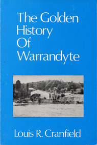
Book - The Golden History of Warrandyte, Louis R. Cranfield, 1982
This edition covers Warrandyte from the earliest days of the discovery of gold and the setting up of a mining camp - through its transition to become a thriving township attracting thousands of holiday visitors - is a factual survey of more than a hundred years of community life in Warrandyte, Victoria, Australia.an 18 cm book, 128p, includes 4 pics.non-fictionThis edition covers Warrandyte from the earliest days of the discovery of gold and the setting up of a mining camp - through its transition to become a thriving township attracting thousands of holiday visitors - is a factual survey of more than a hundred years of community life in Warrandyte, Victoria, Australia.gold mines and mining -- victoria -- warrandyte -- history, warrandyte -
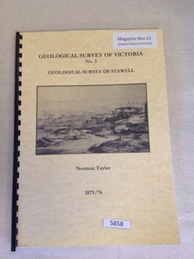 Stawell Historical Society Inc
Book, Norman Taylor, Geological Survey of Victoria No3, Geological Survey of Stawell, 1875-1876
... , Geological Surveyor stawell mining Geological Survey of Victoria No.3 ...Geological Survey of Stawell 1875/76 by Norman Taylor, Geological SurveyorYellow Card Front and Rear Cover with B/W Picture of mining scene. with black Plastic spineGeological Survey of Victoria No.3 Geological Survey of Stawell Norman Taylor 1875/76stawell mining -
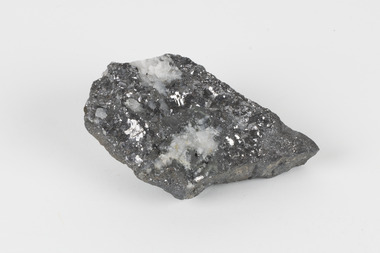 The Beechworth Burke Museum
Geological specimen - Galena (with quartz), unknown
Galena is the natural compound of lead and classed as a sulphide, it crystallises in a cubic pattern and its chemical formula is PbS. Galena is a primary source of both lead and silver. This specimen of Galena comes from Broken Hill. Broken Hill has one of the world’s largest and most significant deposit of ore for the production of lead. Mining of Galena at Broken Hill began with the staking of land by Charles Rasp in 1883. By the following year, in 1884, Rasp and six others had formed Broken Hill Mining Company. Broken Hill Mining Company eventually evolved into BHP group limited and is currently the largest mining company in the world and the largest company in Australia. There is archaeological evidence from artefacts discovered in Turkey that humans have been extracting lead from galena by the process of smelting since at least 6500 BCE. This specimen also has quartz on the top surface which is frequently discovered alongside Galena. This mineral specimen is of historic significance as a sample of Galena extracted from Broken Hill during the 19th century. Mining for Galena in Broken Hill begin in 1883 by Charles Rasp and evolved into the world’s largest mining company – BHP Group Limited. Broken Hill is one of the world’s most significant deposits of ore for the production of lead. This specimen is part of a larger collection of geological and mineral specimens collected from around Australia (and some parts of the world) and donated to the Burke Museum between 1868-1880. A large percentage of these specimens were collected in Victoria as part of the Geological Survey of Victoria that begun in 1852 (in response to the Gold Rush) to study and map the geology of Victoria. Collecting geological specimens was an important part of mapping and understanding the scientific makeup of the earth. Many of these specimens were sent to research and collecting organisations across Australia, including the Burke Museum, to educate and encourage further study.A flat, hand-sized, grey sulphide specimen that is the natural compound of lead with a quartz formation on the top surface. Existing Label: GALENA / (with quartz) / Locality: Broken Hill / N.S.W 120 x 70 x 29geological specimen, geology, geology collection, burke museum, beechworth, galena, galena quartz, quartz, charles rasp, broken hill mining company, bhp group limited, bhp, lead, ore, lead sulphide, sulphide, silver, broken hill -
Bendigo Historical Society Inc.
Map - STRUGNALL COLLECTION: BENDIGO GOLD FIELD GEOLOGICAL SURVEY, 1936
BHS CollectionBendigo Goldfieds Geological Survey. Prepared in the Bendigo Office Lower Section of original map. Note with map says other items donated - yet to be catalogued. TO BE FOUNDDept of Mines Victoriabendigo, gold mining, geological map