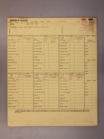
Showing 423 items matching "mmbw"
-
 Melbourne Water
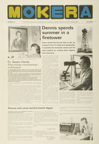
Staff Newsletter, Gwen Hardy, First Woman Commissioner, October, 1975
As the Yarra became unsuitable as a source of water, several attempts were made to find alternative sources for the growing population of Melbourne. It was not until 1891 that the efforts to sewer Melbourne came to fruition with the setting up of the Melbourne Metropolitan Board of Works (MMBW), now known as Melbourne Water. From 1891 until 1992, it was the responsibility of the MMBW to safeguard public health by providing a sewerage system and a safe water supply system. In 1992, The MMBW merged with a number of smaller urban water authorities to form Melbourne Water. Born on the 5th of August,1926, Margaret Gwen Hardy was the very first Commissioner of the Melbourne Metropolitan Board of Works (MMBW) and was appointed in 1975, a major victory for women at the time. This was the first time in the 84 year history of the organisation. Hardy had also been a Lilydale Councillor and went on to become the first female Shire President. Along with her work commitments as part of the Board, Hardy was the wife of Dr. Bill and had three children, two sons and a daughter. Next door to her home in Mt Evelyn was her husband’s surgery, where Hardy also worked part-time as a Manager. Hardy was also involved with the Lilydale High School Mother’s Club, she was the President of the Mt. Evelyn Environment Protection and Progress Association, on the Advisory Council of Monbulk High School and was the Secretary of the Lilydale Citizens Advisory Service at the time. This staff newsletter highlights the historically significant achievement of Cr. Gwen Hardy becoming the first female commissioner to work at the Board in 84 years. This captured achievement highlights women's career advancement at the MMBW and within the Victorian public service, whilst having historic and social associations with the many women's rights movements in the 1970s.comissioner, melbourne water, mmbw, melbourne metropolitan board of works, woman, staff, newsletter -
 Melbourne Water
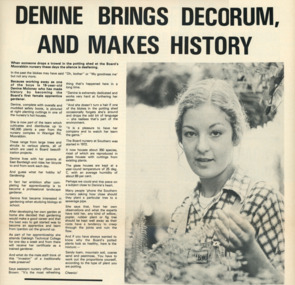
Staff Newsletter, Denine Moloney, First Female Apprentice Gardener, 1979
As the Yarra became unsuitable as a source of water, several attempts were made to find alternative sources for the growing population of Melbourne. It was not until 1891 that the efforts to sewer Melbourne came to fruition with the setting up of the Melbourne Metropolitan Board of Works (MMBW), now known as Melbourne Water. From 1891 until 1992, it was the responsibility of the MMBW to safeguard public health by providing a sewerage system and a safe water supply system. In 1992, The MMBW merged with a number of smaller urban water authorities to form Melbourne Water. Denine Moloney made history at the MMBW as the Board’s first female apprentice gardener, at the young age of 16. Denine was part of a team that cultivated and distributed up to 140,000 plants a year from the nursery complex that was housed on Warrigal Road, in Moorabbin. The large trees, shrubs and various other plants were all used in Board beautification projects. At the time, Denine lived with her parents and rode her bicycle to and from work each day while she attended Oakleigh Technical College one day a week as part of her apprenticeship. Denine’s ambition was to become a professional landscape gardener after her apprenticeship was completed, and four years later was in fact appointed as head gardener at Jells Park in 1983. Denine was not the last woman to work as a gardener at the Board, bringing with her two female assistants at Jells Park in caring, maintaining and distributing the Board’s horticulture. This staff newsletter highlights the significant achievement of Denine Moloney, becoming the first female gardener to work at the Board. This captured achievement highlights women's career advancement at the MMBW and within the Victorian public service, whilst having historic and social associations with the many women's rights movements of the 1970s.gardener, woman, melbourne metropolitan board of works, mmbw, staff, newsletter, 1970s -
 Eltham District Historical Society Inc
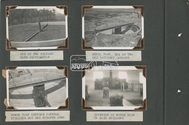
Album - Photograph Album, Alan Gardiner, M.M.B.W Braeside Sewage Treatment Plant Construction, 1939
In April 1928 the MMBW had the land and the plans for what they were to construct but the timing of the actual building did not proceed as planned. Before the construction could commence the Great Depression of the 1930s intervened forcing the shelving of its plans. The new owners then offered the land for lease resulting in Frederick Werrett taking the opportunity to take up the land he formerly owned to continue his market gardening activities of growing potatoes, onions and other crops. The land and improvements made by Syme were leased in 1929 to Harry Telford a trainer from New South Wales. Phar Lap grazed there for a short time. [9] However the population of Melbourne continued to grow and the need for a sewerage treatment plant did not go away. In 1939 when the effects of the Depression had dissipated work on the Sewerage Effluent Treatment Plant commenced and the following year in October the Premier of the State, Albert Dunstan, officially commissioned it. The Sewerage Effluent Treatment Plant at Braeside served the communities of south-east Melbourne for thirty five years until 1975. In that year all the sewers that entered the Braeside plant were diverted to the South Eastern Trunk Sewer complex at Carrum.[10] In 1982 the chairman of the MMBW at that time, Alan Croxford, announced that a substantial part of the property at Braeside would be administered by the Parks and Gardens section of MMBW as a public park. Subsequently the responsibilities were transferred to Parks Victoria, the situation that exists today. It is known as “Braeside Park” now. [Source: Sewerage Treatment Plant at Braeside, Kingston Local History, https://localhistory.kingston.vic.gov.au/articles/407]alan gardiner collection, 1939, braeside sewage treatment plant, construction, melbourne metropolitan board of works, mmbw -
 Eltham District Historical Society Inc
Album - Photograph Album, Alan Gardiner, M.M.B.W Braeside Sewage Treatment Plant Construction, 1939
In April 1928 the MMBW had the land and the plans for what they were to construct but the timing of the actual building did not proceed as planned. Before the construction could commence the Great Depression of the 1930s intervened forcing the shelving of its plans. The new owners then offered the land for lease resulting in Frederick Werrett taking the opportunity to take up the land he formerly owned to continue his market gardening activities of growing potatoes, onions and other crops. The land and improvements made by Syme were leased in 1929 to Harry Telford a trainer from New South Wales. Phar Lap grazed there for a short time. [9] However the population of Melbourne continued to grow and the need for a sewerage treatment plant did not go away. In 1939 when the effects of the Depression had dissipated work on the Sewerage Effluent Treatment Plant commenced and the following year in October the Premier of the State, Albert Dunstan, officially commissioned it. The Sewerage Effluent Treatment Plant at Braeside served the communities of south-east Melbourne for thirty five years until 1975. In that year all the sewers that entered the Braeside plant were diverted to the South Eastern Trunk Sewer complex at Carrum.[10] In 1982 the chairman of the MMBW at that time, Alan Croxford, announced that a substantial part of the property at Braeside would be administered by the Parks and Gardens section of MMBW as a public park. Subsequently the responsibilities were transferred to Parks Victoria, the situation that exists today. It is known as “Braeside Park” now. [Source: Sewerage Treatment Plant at Braeside, Kingston Local History, https://localhistory.kingston.vic.gov.au/articles/407]alan gardiner collection, 1939, braeside sewage treatment plant, construction, melbourne metropolitan board of works, mmbw -
 Canterbury History Group
Document - The Grange, 1905
MMBW detailed map of "The Grange" 1905. Includes a short history of the house by Don Gibbcanterbury, the grange, fintona junior school, st. duthies, mont albert road, maps, gibb> don -
 Kew Historical Society Inc
Plan, Melbourne & Metropolitan Board of Works : Borough of Kew : Detail Plan No.1592, 1905
The Melbourne and Metropolitan Board of Works (MMBW) plans were produced from the 1890s to the 1950s. They were crucial to the design and development of Melbourne's sewerage and drainage system. The plans, at a scale of 40 feet to 1 inch (1:480), provide a detailed historical record of Melbourne streetscapes and environmental features. Each plan covers one or two street blocks (roughly six streets), showing details of buildings, including garden layouts and ownership boundaries, and features such as laneways, drains, bridges, parks, municipal boundaries and other prominent landmarks as they existed at the time each plan was produced. (Source: State Library of Victoria). This plan forms part of a large group of MMBW plans and maps that was donated to the Society by the Mr Poulter, City Engineer of the City of Kew in 1989. Within this collection, thirty-five hand-coloured plans, backed with linen, are of statewide significance as they include annotations that provide details of construction materials used in buildings in the first decade of the 20th century as well as additional information about land ownership and usage. The copies in the Public Record Office Victoria and the State Library of Victoria are monochrome versions which do not denote building materials so that the maps in this collection are invaluable and unique tools for researchers and heritage consultants. A number of the plans are not held in the collection of the State Library of Victoria so they have the additional attribute of rarity.Original survey plan, issued by the MMBW to a contractor with responsibility for constructing sewers in the area identified on the plan within the Borough of Kew. The plan was at some stage hand-coloured, possibly by the contractor, but more likely by officers working in the Engineering Department of the Borough and later Town, then City of Kew. The hand-coloured sections of buildings on the plan were used to denote masonry or brick constructions (pink), weatherboard constructions (yellow), and public buildings (grey). In MMBW Plan No.1592, the pink line indicates that area of the plan for which the contracting engineer was responsible. Included in the Plan are a number of primarily brick villas in a section of Belmont Avenue off Cotham Road. The house ‘Uvadale’ north of Belmont Avenue, and facing Cotham Road is also included in the contract. Excluded from the contract but shown on the Plan are ‘Glendonald’, ‘Mont Belmont’ and ‘Gilden’.melbourne and metropolitan board of works, detail plans, survey plans - borough of kew, mmbw 1592, cartography -
 Kew Historical Society Inc
Plan, Melbourne & Metropolitan Board of Works : Borough of Kew : Detail Plan No.1561, 1905
The Melbourne and Metropolitan Board of Works (MMBW) plans were produced from the 1890s to the 1950s. They were crucial to the design and development of Melbourne's sewerage and drainage system. The plans, at a scale of 40 feet to 1 inch (1:480), provide a detailed historical record of Melbourne streetscapes and environmental features. Each plan covers one or two street blocks (roughly six streets), showing details of buildings, including garden layouts and ownership boundaries, and features such as laneways, drains, bridges, parks, municipal boundaries and other prominent landmarks as they existed at the time each plan was produced. (Source: State Library of Victoria). This plan forms part of a large group of MMBW plans and maps that was donated to the Society by Mr Poulter, City Engineer of the City of Kew in 1989. Within this collection, thirty-five hand-coloured plans, backed with linen, are of statewide significance as they include annotations that provide details of construction materials used in buildings in the first decade of the 20th century as well as additional information about land ownership and usage. The copies in the Public Record Office Victoria and the State Library of Victoria are monochrome versions which do not denote building materials so that the maps in this collection are invaluable and unique tools for researchers and heritage consultants. A number of the plans are not held in the collection of the State Library of Victoria so they have the additional attribute of rarity.Original survey plan, issued by the MMBW to a contractor with responsibility for constructing sewers in the area identified on the plan within the Borough of Kew. The plan was at some stage hand-coloured, possibly by the contractor, but more likely by officers working in the Engineering Department of the Borough and later Town, then City of Kew. The hand-coloured sections of buildings on the plan were used to denote masonry or brick constructions (pink), weatherboard constructions (yellow), and public buildings (grey). MMBW Detail Plan 1561 outlines those residences in the area bordered by Burke Road, Loxton Street, Mount Street and Barkers Road that had been constructed by 1905 when the land was surveyed. At this time, the area nearest Burke Road had been subdivided and developed whereas the lands to the west were as yet undeveloped. The houses represented are not named on the Plan.melbourne and metropolitan board of works, detail plans, mmbw 1561, cartography -
University of Melbourne, Burnley Campus Archives
Document, Report on the existing vegetation and most likely previous patterns of vegetation at Point Cook Metropolitan Park, 1984
Prepared by David Cantrill and Ian Lunt, based on MMBW brief, 55 pp., 2 copiesvegetation, david cantrill, ian lunt, point cook, parks -
Whitehorse Historical Society Inc.
Article, Putting the Lid on Sources of Water, 1987
MMBW undertakes major reservoir covering and replacement program.MMBW undertakes major reservoir covering and replacement program to ensure water supply is constant and safe.MMBW undertakes major reservoir covering and replacement program.wilkes, john, mitcham reservoir, melbourne metropolitan board of works -
![Photograph - Construction of the F19 [Eastern Freeway], Ron Setford, May 1976](/media/collectors/550653872162f11fb04854aa/items/6815b03d8b3331834378a6c9/item-media/6815b0708b3331834378ab4c/item-fit-380x285.jpg) Kew Historical Society Inc
Kew Historical Society IncPhotograph - Construction of the F19 [Eastern Freeway], Ron Setford, May 1976
Ron Setford and his wife Grace Setford lived in Tanner Avenue, East Kew, from c.1946 to c.1995. A keen photographer, he recorded the changing face of Kew over a 20 year period. Apart from 30 photographs of built structures and places in Kew dating from 1960 and 1961, 145 of his 35mm colour slides chronicle the development of the F19 (later renamed Eastern) Freeway through the Yarra Valley in Kew over a five year period from c.1972 to c.1977. This important collection was donated to the Society by his granddaughter in 2025.This collection of 175 35mm slides is of local and statewide significance, owing to its subject matter, particularly the major development of road transport infrastructure during the 1970s with the construction of the Eastern Freeway. The photographer also took care to annotate and date most of his slides which enable the researcher to pinpoint temporal and spatial locations."Old bridge works MMBW, New bridge works CRB / Main bridges over Yarra River / Fairfield - Kew"ron setford, eastern freeway, f19 freeway -
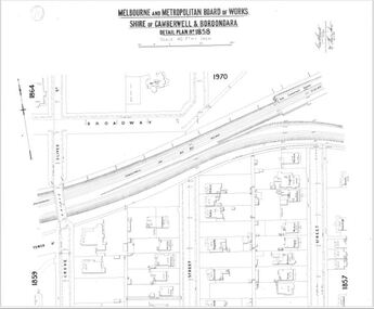
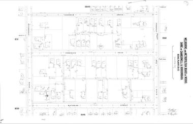
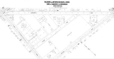 Camberwell Historical Society
Map (Item) - MMBW map, Melbourne and Metropolitan Board of Works, Melbourne and Metropolitan Board of Works - Shire of Boroondara and Camberwell - Detail Plan no. 1852, August 1904
Lithographer L.E, exd W.A.L., August 1904, no. 95. 40P. 15Wmelbourne and metropolitan board of works, map, camberwell, cartography -
 Kew Historical Society Inc
Plan, Melbourne and Metropolitan Board of Works, Melbourne & Metropolitan Board of Works : Borough of Kew : Detail Plan No.1294 & 1295, 1904
The Melbourne and Metropolitan Board of Works (MMBW) plans were produced from the 1890s to the 1950s. They were crucial to the design and development of Melbourne's sewerage and drainage system. The plans, at a scale of 40 feet to 1 inch (1:480), provide a detailed historical record of Melbourne streetscapes and environmental features. Each plan covers one or two street blocks (roughly six streets), showing details of buildings, including garden layouts and ownership boundaries, and features such as laneways, drains, bridges, parks, municipal boundaries and other prominent landmarks as they existed at the time each plan was produced. (Source: State Library of Victoria). This plan forms part of a large group of MMBW plans and maps that was donated to the Society by the Mr Poulter, City Engineer of the City of Kew in 1989. Within this collection, thirty-five hand-coloured plans, backed with linen, are of statewide significance as they include annotations that provide details of construction materials used in buildings in the first decade of the 20th century as well as additional information about land ownership and usage. The copies in the Public Record Office Victoria and the State Library of Victoria are monochrome versions which do not denote building materials so that the maps in this collection are invaluable and unique tools for researchers and heritage consultants. A number of the plans are not held in the collection of the State Library of Victoria so they have the additional attribute of rarity.Original survey plan, issued by the MMBW to a contractor with responsibility for constructing sewers in the area identified on the plan within the Borough of Kew. The plan was at some stage hand-coloured, possibly by the contractor, but more likely by officers working in the Engineering Department of the Borough and later Town, then City of Kew. The hand-coloured sections of buildings on the plan were used to denote masonry or brick constructions (pink), weatherboard constructions (yellow), and public buildings (grey).The streets and built structures in MMBW Detail Plan 1294 & 1295 were surveyed in 1903 and released to contractors in 1904. This plan is one of two in the collection where the lithographers amalgamated two separate plans. Both plans include sections of Studley Park. Dominating the south and west corners of Kew Junction are the Clifton and Kew Hotels. The Kew Hotel, owned by Patrick O’Shaughnessy was one of the oldest in Kew. MMBW plans were amended over time to take account of new subdivisions such as that which created Merrion Place. Of the four mansions shown in Studley Park Road, three remain – ‘Field Place’, the home of Frances Henty, ‘Leaghur’ and ‘Darley’. ‘Byram’ (later ‘Goathland’, then ‘Tara Hall’) was an architectural marvel. Designed in 1888 by E.G. Kilburn for the paper magnate George Ramsden, it was demolished in 1960. While an earlier sale of the southern section of Byram had created Tara Avenue in 1927, the demolition of the house in 1960 enabled the extension of Tara Avenue northward.melbourne and metropolitan board of works, detail plans, mmbw 1294, mmbw 1295, cartography -
Melbourne Tram Museum
Newspaper, The News Adelaide, "Ways of Transport - City Tramways Indispensable - Favours Not Sought", 15/11/1926 12:00:00 AM
Newspaper clipping - from The News Adelaide, 15 Nov. 1926 (checked by searching Trove), titled "Ways of Transport - City Tramways Indispensable - Favours Not Sought". Notes the remarks made by Mr. W Riddell, Chairman of the MMBW who said electric tramways were obsolete. Quotes response by Mr. W Goodman who gives information on London congestion, journals issues with buses and motor vehicles. Item was pinned to Reg Item 3876.Has ink on top "The News"trams, tramways, tramways, electric traction, adelaide, mmbw, traffic control, london -
 Ringwood and District Historical Society
Administrative record - Rate Books, Borough of Ringwood Valuation & Rate Cards for 1944-49 (Assessments 1414-1419), March 2012
Originally stored at Ringwood Council offices, then taken to PROV.Only source of ratepayers in the Borough of RingwoodDigital imagesMontalbo Road, Ringwood. Pinemont Estate. For Jessie Woodward, MMBW, Catherine Page, Eiler Busch, Lena Wisby and Herbert Price. -
 Camberwell Historical Society
Map (Item) - MMBW map, Melbourne and Metropolitan Board of Works, Melbourne and Metropolitan Board of Works - Shire of Boroondara and Camberwell - Detail Plan no. 1858, August 1904
Lithographer E.H.H., Exd J.W.D, Aug 1904, No. 103. 40P.15W.melbourne and metropolitan board of works, map, camberwell, cartography -
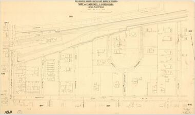 Camberwell Historical Society
Map (Item) - MMBW map, Melbourne and Metropolitan Board of Works, Melbourne and Metropolitan Board of Works - Shire of Boroondara and Camberwell - Detail Plan no. 1860, August 1904
Lithographer E.H.H., Exd J.W.D, June 1904, No. 70. 40P.15W.melbourne and metropolitan board of works, map, camberwell, cartography -
 Kew Historical Society Inc
Plan, Melbourne and Metropolitan Board of Works, Borough of Kew : Detail Plan No.1562, 1905
The Melbourne and Metropolitan Board of Works (MMBW) plans were produced from the 1890s to the 1950s. They were crucial to the design and development of Melbourne's sewerage and drainage system. The plans, at a scale of 40 feet to 1 inch (1:480), provide a detailed historical record of Melbourne streetscapes and environmental features. Each plan covers one or two street blocks (roughly six streets), showing details of buildings, including garden layouts and ownership boundaries, and features such as laneways, drains, bridges, parks, municipal boundaries and other prominent landmarks as they existed at the time each plan was produced. (Source: State Library of Victoria). This plan forms part of a large group of MMBW plans and maps that was donated to the Society by the Mr Poulter, City Engineer of the City of Kew in 1989. Within this collection, thirty-five hand-coloured plans, backed with linen, are of statewide significance as they include annotations that provide details of construction materials used in buildings in the first decade of the 20th century as well as additional information about land ownership and usage. The copies in the Public Record Office Victoria and the State Library of Victoria are monochrome versions which do not denote building materials so that the maps in this collection are invaluable and unique tools for researchers and heritage consultants. A number of the plans are not held in the collection of the State Library of Victoria so they have the additional attribute of rarity.Original survey plan, issued by the MMBW to a contractor with responsibility for constructing sewers in the area identified on the plan within the Borough of Kew. The plan was at some stage hand-coloured, possibly by the contractor, but more likely by officers working in the Engineering Department of the Borough and later Town, then City of Kew. The hand-coloured sections of buildings on the plan were used to denote masonry or brick constructions (pink), weatherboard constructions (yellow), and public buildings (grey). MMBW detail plan No.1562, in contrast to No.1561 includes the names of a large number of houses: in Barkers Road: ‘Ashwick’, ‘Owasso’, ‘Anadiha’, ‘Eurobin’, ‘Carlsruhe’, ‘Arlington’ and ‘Altyre’. Unnamed but clearly represented on the plan is what was then known as the ‘Auburn Heights Recreation Club’, which at this stage included a Bowling Green, a Croquet Green and two Tennis Courts. On the plan, Brougham Place, as it was then known, is represented. It was later renamed Daniell Place. The aforementioned Arlington is now the junior campus of Preshil. melbourne and metropolitan board of works, detail plans, mmbw 1562, cartography -
Port Melbourne Historical & Preservation Society
Map - Melbourne and suburbs, MMBW, 8 Dec 1909
MMBW map of Melbourne and suburbs - Record plan up to July 1st 1913 (scale 3/4" = 1 mile)engineering - board of works, calder e oliver, russwaul(?) -
 Camberwell Historical Society
Map (Item) - MMBW map, Melbourne and Metropolitan Board of Works, Melbourne and Metropolitan Board of Works - Shire of Boroondara and Camberwell - Detail Plan no. 1851, July 1904
Lithographer JEM, exd. JWD, July 1904, no. 81, 40P. 15W.melbourne and metropolitan board of works, map, camberwell, cartography -
 Kew Historical Society Inc
Plan, Melbourne & Metropolitan Board of Works : Borough of Kew : Detail Plan No.1578, 1904
The Melbourne and Metropolitan Board of Works (MMBW) plans were produced from the 1890s to the 1950s. They were crucial to the design and development of Melbourne's sewerage and drainage system. The plans, at a scale of 40 feet to 1 inch (1:480), provide a detailed historical record of Melbourne streetscapes and environmental features. Each plan covers one or two street blocks (roughly six streets), showing details of buildings, including garden layouts and ownership boundaries, and features such as laneways, drains, bridges, parks, municipal boundaries and other prominent landmarks as they existed at the time each plan was produced. (Source: State Library of Victoria). This plan forms part of a large group of MMBW plans and maps that was donated to the Society by the Mr Poulter, City Engineer of the City of Kew in 1989. Within this collection, thirty-five hand-coloured plans, backed with linen, are of statewide significance as they include annotations that provide details of construction materials used in buildings in the first decade of the 20th century as well as additional information about land ownership and usage. The copies in the Public Record Office Victoria and the State Library of Victoria are monochrome versions which do not denote building materials so that the maps in this collection are invaluable and unique tools for researchers and heritage consultants. A number of the plans are not held in the collection of the State Library of Victoria so they have the additional attribute of rarity.Original survey plan, issued by the MMBW to a contractor with responsibility for constructing sewers in the area identified on the plan within the Borough of Kew. The plan was at some stage hand-coloured, possibly by the contractor, but more likely by officers working in the Engineering Department of the Borough and later Town, then City of Kew. The hand-coloured sections of buildings on the plan were used to denote masonry or brick constructions (pink), weatherboard constructions (yellow), and public buildings (grey). MMBW Plan No.1578 is significant in that it defines the extent of two private schools: Xavier College and Kew High School (now part of Trinity Grammar) by 1904. In relation to the latter, the plan clarifies which buildings the High School operated from behind the mansion ‘Molina’. Established in 1902, Trinity Grammar was to later lease and subsequently buy Molina (now ‘Merritt House’) and ‘Elsinore’ (now ‘Roberts House’). Xavier College had been established in 1872. This 1904 plan delineates the West Wing and the Great Hall (built in 1890).melbourne and metropolitan board of works, detail plans, maps - borough of kew, mmbw 1578, cartography -
 Melbourne Legacy
Letter - Document, letter, 10/03/1943
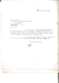
Letter dated 10 March 1943 to the Melbourne and Metropolitan Board of Works about the retention of an internal water closet at 1267 Burke Road, Kew (Holmbush). Legacy accepted responsibility for any trouble which may arise through this fitting which was not directly supplied from a Storage Tank. Holmbush was the first hostel for children that Legacy started and operated from April 1943. It was later renamed Blamey House after another hostel called Blamey House was closed. Melbourne Legacy ran three residences: Blamey House (purchased 1947) , Stanhope (purchased 1945) and Harelands (purchased 1950), to take care of children whose fathers were servicemen, and who may have been left orphans, or whose mother may have been unable to care for them herself. Harelands accommodated boys and girls under the age of 14, Blamey House looked after boys over 14, and Stanhope looked after girls over 14. The children were cared for until they were old enough to become independent.A record of written correspondence in 1943 especially concerning consulting the MMBW about sewer connections.File copy of a letter to MMBW about a WC at Holmbush on white quarto copy paper, with black type, two hole punched.Initialled in ink, possibly EB.residences, holmbush, holmbush administration -
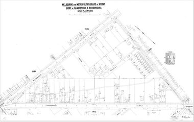
 Camberwell Historical Society
Map (Item) - MMBW map, Melbourne and Metropolitan Board of Works, Melbourne and Metropolitan Board of Works - Shire of Boroondara and Camberwell - Detail Plan no. 1845, August 1904
Lithographer JEM, exd. JWD, June 1904, no. 71. 40P.15W.melbourne and metropolitan board of works, map, camberwell, cartography -
 Melbourne Tram Museum
Slide - Set of 2, Warren Doubleday, Dec. 1970
Set of 2 Colour slides- Anscochrome plastic mount taken during 12/70 of W7 1024 (Spencer St Route 74) in Flinders St dressed as the MMTB Christmas Tram .1 - running alongside the Flinders St viaduct. .2 - in Spencer St between Little Collins St and Collins St (Burwood Route 74) with the MMBW building under construction and 616 Little Collins St (MMTB Head Office) in the background. In the view is a shop selling Cadbury's Chocolate.Has slide number written on itemtrams, tramways, w7 class, mmtb, mmbw, route 74, spencer st, flinders st, tram 1024 -
 Kew Historical Society Inc
Plan, Melbourne & Metropolitan Board of Works : Borough of Kew : Detail Plan No.1350, 1910
The Melbourne and Metropolitan Board of Works (MMBW) plans were produced from the 1890s to the 1950s. They were crucial to the design and development of Melbourne's sewerage and drainage system. The plans, at a scale of 40 feet to 1 inch (1:480), provide a detailed historical record of Melbourne streetscapes and environmental features. Each plan covers one or two street blocks (roughly six streets), showing details of buildings, including garden layouts and ownership boundaries, and features such as laneways, drains, bridges, parks, municipal boundaries and other prominent landmarks as they existed at the time each plan was produced. (Source: State Library of Victoria). This plan forms part of a large group of MMBW plans and maps that was donated to the Society by the Mr Poulter, City Engineer of the City of Kew in 1989. Within this collection, thirty-five hand-coloured plans, backed with linen, are of statewide significance as they include annotations that provide details of construction materials used in buildings in the first decade of the 20th century as well as additional information about land ownership and usage. The copies in the Public Record Office Victoria and the State Library of Victoria are monochrome versions which do not denote building materials so that the maps in this collection are invaluable and unique tools for researchers and heritage consultants. A number of the plans are not held in the collection of the State Library of Victoria so they have the additional attribute of rarity.Original survey plan, issued by the MMBW to a contractor with responsibility for constructing sewers in the area identified on the plan within the Borough of Kew. The plan was at some stage hand-coloured, possibly by the contractor, but more likely by officers working in the Engineering Department of the Borough and later Town, then City of Kew. The hand-coloured sections of buildings on the plan were used to denote masonry or brick constructions (pink), weatherboard constructions (yellow), and public buildings (grey). MMBW Plan No. 1350 depicts the western end of Studley Park on the north side of the Studley Park Road. ‘Raheen’, then the home of Sir Henry Wrixon is named, the plan identifying those parts of the house that were built of brick and timber. The two houses between Raheen and the River Yarra are also shown. Other parts of the plan show neighbouring streets: Yarra Street, Studley Park Avenue, Studley Street and Fenwick Street. Each, apart from Fenwick Street was subsequently renamed. At the corner of Fenwick and Stawell Streets, the home of Joseph Butterworth Coombs, later called ‘Hope Mansell’, is represented but unnamed.melbourne and metropolitan board of works, detail plans, mmbw 1350, cartography -
 Kew Historical Society Inc
Plan, Melbourne & Metropolitan Board of Works : Borough of Kew : Detail Plan No.1565, 1905
The Melbourne and Metropolitan Board of Works (MMBW) plans were produced from the 1890s to the 1950s. They were crucial to the design and development of Melbourne's sewerage and drainage system. The plans, at a scale of 40 feet to 1 inch (1:480), provide a detailed historical record of Melbourne streetscapes and environmental features. Each plan covers one or two street blocks (roughly six streets), showing details of buildings, including garden layouts and ownership boundaries, and features such as laneways, drains, bridges, parks, municipal boundaries and other prominent landmarks as they existed at the time each plan was produced. (Source: State Library of Victoria). This plan forms part of a large group of MMBW plans and maps that was donated to the Society by the Mr Poulter, City Engineer of the City of Kew in 1989. Within this collection, thirty-five hand-coloured plans, backed with linen, are of statewide significance as they include annotations that provide details of construction materials used in buildings in the first decade of the 20th century as well as additional information about land ownership and usage. The copies in the Public Record Office Victoria and the State Library of Victoria are monochrome versions which do not denote building materials so that the maps in this collection are invaluable and unique tools for researchers and heritage consultants. A number of the plans are not held in the collection of the State Library of Victoria so they have the additional attribute of rarity.Original survey plan, issued by the MMBW to a contractor with responsibility for constructing sewers in the area identified on the plan within the Borough of Kew. The plan was at some stage hand-coloured, possibly by the contractor, but more likely by officers working in the Engineering Department of the Borough and later Town, then City of Kew. The hand-coloured sections of buildings on the plan were used to denote masonry or brick constructions (pink), weatherboard constructions (yellow), and public buildings (grey). MMBW Plan No.1565 is an example of a plan where a number of streets have been created since the area was surveyed, or in other cases renamed. The plan shows those streets that were bordered by Ross Street, Mount Street, Sackville Street and Burke Road. Since 1905, Mawson Street has been created and Mont Albert Road renamed as Dean Street. Named houses on the plan include ‘Tyrol’, ‘Glengorse’, ‘Theodore Villa’, ‘Arncliffe’, ‘Ballynira’ and ‘Hazeldene’. The plan also shows a Wesleyan Church in Sackville Street. In 1883, the Church’s Sunday School celebrated its silver anniversary.melbourne and metropolitan board of works, detail plans, mmbw 1565, cartography -
Whitehorse Historical Society Inc.
Map, Mitcham Riding, n.d
Shire of Nunawading: Mitcham Riding [n.d.] (between Springvale and Mitcham Roads) (Shows electric light mains. MMBW reserves, railway line.)mitcham, maps, tunstall, forest hill -
Whitehorse Historical Society Inc.
Map, Mitcham Riding, n.d
Shire of Nunawading: Mitcham Riding [n.d.] between Mitcham and Heatherdale Roads) (Shows electric light mains, MMBW reserves and railway line.mitcham, maps, vermont -
 Melbourne Water
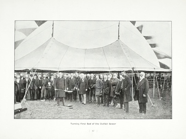
Photograph - Turning Of The First Sod, 1908
The 19th of May marks the anniversary of the turning of the first sod of the outfall sewer. In 1888, a Royal Commission into Melbourne’s public health led to an ambitious plan to construct a sewerage system of underground pipes, sewers and drains to carry sewage from homes and factories to a sewage treatment farm. The commission also supported the establishment of the Melbourne Metropolitan Board of Works (MMBW), the authority that would build the sewerage system and manage Melbourne’s water supply. This photograph is from The Melbourne and Metropolitan Board of Works Water Supply, Sewerage, and etc Photographic Views, 1908This photograph is in excellent condition and provides a detailed insight into Board personnel of the MMBW. It is of historical importance to the history of Melbourne in the turning of the very first sod.Black and white photographphotograph, mmbw, melbourne metropolitan board of works, melbourne water, historic, turniing of the first sod, book, sewerage, water -
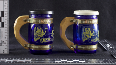 Melbourne Water
Souvenir Salt and Pepper Shakers, 1970s
The Maroondah System was first and foremost developed as a functional component of Melbourne's Water Supply System. In addition to functionality, the Melbourne and Metropolitan Board of Works (MMBW) envisioned the Maroondah Reserve to be enjoyed aesthetically and recreationally by the public. This souvenir illustrates the realisation of the Maroondah System as a local recreational and tourist attraction in the early 20th century. The Maroondah Reserve gardens were landscaped with English-style ornamental stonework, exotic trees, flower beds and rose gardens. All features of the water supply system became widely celebrated as beauty spots that continue to be very popular to this day with tourists and locals alike. This souvenir is a product of that flourishing tourist trade. These water supply sites continue to enhance Melbourne’s charm and liveability and are now recognised as places of cultural and historic significance.These souvenir salt and pepper shakers have been curated by Melbourne Water as they represent an important historical aspect of the organisation by demonstrating the popularity of its water asset sites as recreational places and tourist attractions, and although these sites are functional parts of the water supply system, they were also designed to be enjoyed by the public both aesthetically and recreationally. Additionally, the salt and pepper shakers are aesthetically pleasing as the blue glass and wooden handles demonstrate the design and style of the 1970s. These souvenir salt and pepper shakers feature glass bodies, wooden handles and plastic lids. The salt and pepper shakers are decorated with pictures of koalas, kangaroos and a map of Australia. The text “Maroondah Dam, Vic” has been inscribed on the wooden handles.melbourne metropolitan board of works, mmbw, maroondah, salt and pepper shakers, souvenir, glass, healesville -
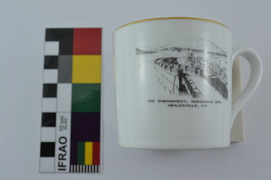 Melbourne Water
Souvenir Tea Cup, 1920s
The Maroondah System was first and foremost developed as a functional component of Melbourne's Water Supply System. In addition to functionality, the Melbourne and Metropolitan Board of Works (MMBW) envisioned the Maroondah Reserve to be enjoyed aesthetically and recreationally by the public. This souvenir illustrates the realisation of the Maroondah System as a local recreational and tourist attraction in the early 20th century. The Maroondah Reserve gardens were landscaped with English-style ornamental stonework, exotic trees, flower beds and rose gardens. All features of the water supply system became widely celebrated as beauty spots that continue to be very popular to this day with tourists and locals alike. This souvenir is a product of that flourishing tourist trade. These water supply sites continue to enhance Melbourne’s charm and liveability and are now recognised as places of cultural and historic significance.This souvenir tea cup has been curated by Melbourne Water as it represents an important historical aspect of the organisation by demonstrating the popularity of its water asset sites as recreational places and tourist attractions, and although these sites are functional parts of the water supply system, they were also designed to be enjoyed by the public both aesthetically and recreationally. Additionally, the tea cup is aesthetically pleasing, representative of 1920s style and design. This porcelain tea cup with gold trim features a black and white image of the embankment at Maroondah Dam, Healesville on the front.melbourne metropolitan board of works, melbourne water, mmbw, porcelain, tea cup, maroondah, healesville