Showing 36252 items
matching old-royal-hotel
-
 Ballarat Heritage Services
Photograph - Colour, Masons' Marks, Old Sarum, England, English Heritage Site, 2016, 01 November 2016
William the Conqueror inherited Old Sarum from the last Saxon king of England. It was an ideal site for a royal castle. It was here in 1070 that William paid off his army after a long and bitter campaign in northern England. It was here in 1086 that he called together all the major landholders in England so they could swear allegiance to him. It was a crucial moment. The Domesday Book was being written, a threatened Viking invasion had only just been averted and William's eldest son was in armed rebellion. Old Sarum was an important place where this Norman king of England held power. In 1794 the Ordnance Survey set out to check the accuracy of the first mapping of Southern England, which had begun ten years earlier. From a point just below Old Sarum Lieutenant William Mudge laid out a base-line 36,574 feet (11,253 metres) long. From each end of the line the positions of distant places were plotted using a huge theodolite made in 1791 by Jesse Ramsden. The accuracy of the process, which was repeated all over England, depended on Jesse Ramsden's craftsmanship and on William Mudge's surveying skill in setting out this first base-line from Old Sarum. The nearer end of Mudge's line is marked by an inscribed stone beside the modern A345 at Old Sarum. ordnance survey, william mudge, jesse ramsden, william the conqueror, old sarum, saxon, 1086, england -
 Ballarat Heritage Services
Photograph - Colour, Masons' Marks, Old Sarum, England, English Heritage Site, 01 November 2016
William the Conqueror inherited Old Sarum from the last Saxon king of England. It was an ideal site for a royal castle. It was here in 1070 that William paid off his army after a long and bitter campaign in northern England. It was here in 1086 that he called together all the major landholders in England so they could swear allegiance to him. It was a crucial moment. The Domesday Book was being written, a threatened Viking invasion had only just been averted and William's eldest son was in armed rebellion. Old Sarum was an important place where this Norman king of England held power. In 1794 the Ordnance Survey set out to check the accuracy of the first mapping of Southern England, which had begun ten years earlier. From a point just below Old Sarum Lieutenant William Mudge laid out a base-line 36,574 feet (11,253 metres) long. From each end of the line the positions of distant places were plotted using a huge theodolite made in 1791 by Jesse Ramsden. The accuracy of the process, which was repeated all over England, depended on Jesse Ramsden's craftsmanship and on William Mudge's surveying skill in setting out this first base-line from Old Sarum. The nearer end of Mudge's line is marked by an inscribed stone beside the modern A345 at Old Sarum. ordnance survey, william mudge, jesse ramsden, william the conqueror, old sarum, saxon, 1086, england -
 Ballarat Heritage Services
Photograph - Colour, Masons' Marks, Old Sarum, England, English Heritage Site, 2016, 01 November 2016
William the Conqueror inherited Old Sarum from the last Saxon king of England. It was an ideal site for a royal castle. It was here in 1070 that William paid off his army after a long and bitter campaign in northern England. It was here in 1086 that he called together all the major landholders in England so they could swear allegiance to him. It was a crucial moment. The Domesday Book was being written, a threatened Viking invasion had only just been averted and William's eldest son was in armed rebellion. Old Sarum was an important place where this Norman king of England held power. In 1794 the Ordnance Survey set out to check the accuracy of the first mapping of Southern England, which had begun ten years earlier. From a point just below Old Sarum Lieutenant William Mudge laid out a base-line 36,574 feet (11,253 metres) long. From each end of the line the positions of distant places were plotted using a huge theodolite made in 1791 by Jesse Ramsden. The accuracy of the process, which was repeated all over England, depended on Jesse Ramsden's craftsmanship and on William Mudge's surveying skill in setting out this first base-line from Old Sarum. The nearer end of Mudge's line is marked by an inscribed stone beside the modern A345 at Old Sarum. ordnance survey, william mudge, jesse ramsden, william the conqueror, old sarum, saxon, 1086, england -
 Ballarat Heritage Services
Photograph - Colour, Masons' Marks, Old Sarum, England, English Heritage Site, 2016, 01 November 2016
William the Conqueror inherited Old Sarum from the last Saxon king of England. It was an ideal site for a royal castle. It was here in 1070 that William paid off his army after a long and bitter campaign in northern England. It was here in 1086 that he called together all the major landholders in England so they could swear allegiance to him. It was a crucial moment. The Domesday Book was being written, a threatened Viking invasion had only just been averted and William's eldest son was in armed rebellion. Old Sarum was an important place where this Norman king of England held power. In 1794 the Ordnance Survey set out to check the accuracy of the first mapping of Southern England, which had begun ten years earlier. From a point just below Old Sarum Lieutenant William Mudge laid out a base-line 36,574 feet (11,253 metres) long. From each end of the line the positions of distant places were plotted using a huge theodolite made in 1791 by Jesse Ramsden. The accuracy of the process, which was repeated all over England, depended on Jesse Ramsden's craftsmanship and on William Mudge's surveying skill in setting out this first base-line from Old Sarum. The nearer end of Mudge's line is marked by an inscribed stone beside the modern A345 at Old Sarum. ordnance survey, william mudge, jesse ramsden, william the conqueror, old sarum, saxon, 1086, england -
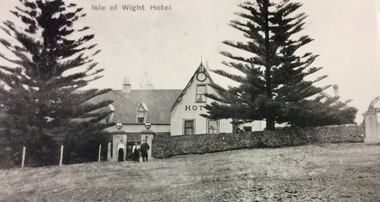
 Phillip Island and District Historical Society Inc.
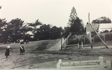
Photograph, Isle of Wight Hotel
Part of collection of Rose & Valentine Postcards. Copied by John Jansson 1984Black & White Postcard. View of Esplanade, Cowes showing the"Isle of Wight" HotelIsle of Wight Hotel, Cowes.local history, photography, photographs, postcards, view cowes, phillip island, black & white postcard, copy, the esplanade cowes -
 Warrnambool and District Historical Society Inc.
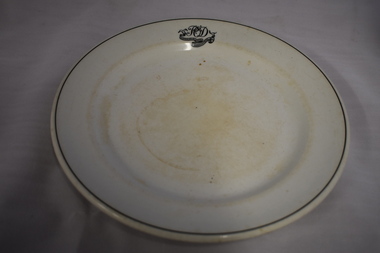
Plate, Commercial Hotel W'bool, 1920s or 1930s
This plate comes from the Commercial Hotel in Warrnambool. This hotel, situated on the north west corner of Liebig and Timor Streets, Warrnambool, was established in 1865. It was built by Thomas Mickle and the first licensee was Charles Anderson. From 1928 on the O’Dwyer family was associated with the Commercial Hotel, either as licensees or owners, for fifty years. The plate would have been first used during the times when Patrick O’Dwyer was the licensee – 1928-1931 and 1932 to 1934. Today the Commercial Hotel still trades as the Whalers Hotel.This plate is of interest as it is a memento of the 1920s and 30s when Patrick O’Dwyer was the licensee of the Commercial Hotel. This hotel, trading today as the Whalers Hotel, is the oldest hotel in Warrnambool and a prominent landmark in the city. This is a white china plate (dinner plate size) with the inner section slightly recessed. The plate has a black line around the outer rim and initials and a hotel name in a scroll pattern on one outer edge. The names of the maker and supplier are on the base of the plate and the top of the plate is somewhat stained. ‘P O’D Commercial Hotel Warrnambool’ ‘Made expressly for John Dynon and Sons, Melbourne Vitrified Globe Pottery Co. Ltd Cobridge England’ commercial hotel / whalers hotel, warrnambool, history of warrnambool -
 Warrnambool and District Historical Society Inc.
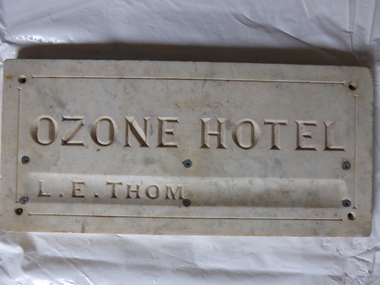
Plaque, Ozone Hotel, 1890
The building to which this tablet was attached was erected in 1890 as the Grand Ozone Coffee Palace. It was at the corner of Koroit and Kepler Streets in Warrnambool and was the most splendid edifice ever erected in Warrnambool. Initially it was a Temperance Hotel but in 1891 it gained a colonial wine licence. Thomas Randall was the lessee and proprietor of the building from 1894 to 1907 and from 1895 on it was called the Ozone Hotel. Mrs Lillias Euphemia Thom was the proprietor from 1907 to 1910. The tablet described herein has her name incised on the tablet ‘L.E.Thom’. The hotel was closed in 1915 and re-opened in 1920 with the new name of Hotel Mansions. The proprietor at that time was Howard Lawson. In 1923 Hotel Mansions gained a full hotel licence but in 1929 the building was destroyed by fire. The present day Hotel Warrnambool now occupies the site of the Hotel Mansions. This tablet is of great significance as it is an important memento of the Grand Ozone Coffee Palace/Ozone Hotel/Hotel Mansions. This building was the most elegant building ever to be erected in Warrnambool and, as such, a reminder of the type of luxury accommodation offered to visitors to Warrnambool in the late 19th and early 20th centuries. This was a time when Warrnambool was promoted as a spa resort with hot and cold sea baths and bracing sea breezes. The marble tablet is an indication of the splendor of the hotel’s furnishings and accoutrements. This is a rectangular marble slab with incised gold lettering (now somewhat faded). The bottom lettering is contained in a slight groove in the marble. There are four holes at each corner and six smaller holes along the edges of the tablet for attachment by screws to a building. The slab has some staining and a little rust. ‘Ozone Hotel’ ‘L.E.Thom’ grand ozone coffee palace (warrnambool), ozone hotel (warrnambool), hotel mansions, history of warrnambool, lillias thom -
 Buninyong Visitor Information Centre
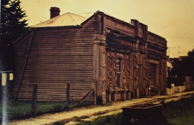
Photograph - Folio of Photographs, Old Buninyong Library
Images of the Old Buninyong Library show the building in a semi-dilapidated condition. The images were taken fifteen before the efforts began to restore the building for public and commercial use. Refer to the Information Folders within the BVIC Archives records for further information. The Buninyong Community website includes a brief history of the building. A red folder containing a group of photographs of the Old Buninyong Library taken by Barry Cox in October 1964. Old Buninyong Libraryold buninyong library, heritage buildings, libraries, heritage preservation -
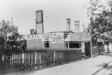
 Hume City Civic Collection
Photograph, Rupertswood Hotel, 1878
The Rupertswood Hotel used to occupy the intersection of Evans and Brook Streets on the SE corner. It was demolished in the 1970s to make way for a modern retail complex. A photo of the Ruperstwood Hotel, on the corner of Evans Street and Brook Street, with a group of people and a horse and carriage outside it. The group is comprised of 5 men, 1 youth, 5 girls and a woman in the carriage. There is a sign on the fence stating " Horses and buggies always for hire. Good stabling" and on the building "Superior Wines and Spirits"; "Rupertswood Hotel" and "G. Millett. Licensed Victualler"The photo is mounted on a light brown cardboard matt, which is extremely brittle. The lower LH corner is cracked. The upper RH corner is missing and there are a number of pin holes in the corners.Handwritten on face: "McAlpine Bros - Rupertswood Hotel, Sunbury. E. Richd. Melb.April 16 1895" Handwritten on back: "Hazeldines"rupertswood hotel, hotels, buildings, evans street, brook street, sunbury, wines, transport, millett, victuallers, mcalpine brothers, hazeldines, george evans collection -
 Phillip Island and District Historical Society Inc.
Photograph, Isle of Wight Hotel
Part of collection of Rose & Valentine Postcards. Copied by John Jansson 1984Black & White Postcard. View of Cowes "Isle of Wight" Hotel showing entrance gate with 2 Ladies and 1 Gent.Isle of Wight Hotellocal history, photography, photographs, postcards, view cowes, phillip island, black & white postcard - copy, isle of wight, cowes -
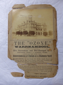 Warrnambool and District Historical Society Inc.
Poster, Ozone Hotel, 1896
This poster advertises the Ozone Hotel in Warrnambool. The poster can be dated to 1896 or thereabouts as it quotes the testimonials of the Governor of Victoria, Lord Brassey and Lady Brassey who stayed at the hotel twice in 1896. The Ozone Hotel, at the corner of Koroit and Kepler Streets, Warrnambool, was opened in 1890 as the Grand Ozone Coffee Palace, a temperance hotel. In 1891 it was granted a colonial wine licence and in 1895 it became known as the Ozone Hotel (a private hotel with superior accommodation). From 1894 to 1907 Thomas Randall was the proprietor. In 1923 the hotel, by then known as Hotel Mansions, became a fully licensed hotel. The building was burnt down in 1929. Although very tattered, this is a significant item. It is an original poster of the Ozone Hotel. The building (Grand Ozone Coffee Palace/Ozone Hotel/Hotel Mansions) was very important in Warrnambool’s history. It was the grandest building ever erected in Warrnambool and a memento of the days when temperance hotels were prevalent in Victoria and tourism was beginning to be important in Warrnambool. This is an advertising poster made of buff-coloured, heavyweight cardboard. It has a sepia-coloured photograph of the Ozone Hotel at the top and black printed material on the bottom half. The poster is completely torn in two with two edge sections also detached. Parts of the top left and bottom left corner are missing. There is evidence of adhesive tape having been used for mending purposes in the past and the whole poster is a little grubby. The paper is now very brittle. ‘The “Ozone” Warrnambool’ ‘This commodious and well-managed hotel containing nearly a hundred rooms, is replete with every comfort for the accommodation of visitors at a moderate tariff …..’ ozone hotel, warrnambool, history of warrnambool -
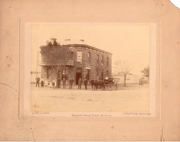
 Eltham District Historical Society Inc
Photograph, Royal Mail Hotel, Diamond Creek; destroyed by fire, 1925
This hotel was located in Chute Street Diamond Creek. The site was from the C.F.A. station east to the corner. In 1925 this hotel was burnt down at 11.00 am on a week day and the street was closed by police because the lighting system used petrol gas and an explosion was feared. Fortunately there was no explosion. This photo shows the gutted structure after the fire. Yarra Plenty Regional Library https://yprl.bibliocommons.com/item/show/485980027_royal_mail_hotel,_diamond_creekBlack and white copy of photo printed on glossy photographic paper 30.5 x 40.5 cm (12 x 16 inch); image size approx. 18.5 x 28 cmchute street, diamond creek, fire damage - buildings, royal mail hotel -
 Alfred Hospital Nurses League - Nursing Archive
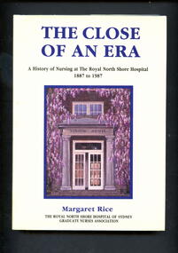
Book - Illustrated book, Margaret Rice, The close of an era: a history of nursing at the Royal North Shore Hospital, 1887 to 1987, 1988
This book is an account of the development of nursing practice as the original North Shore cottage hospital progressed to becoming one of the major medical institutions of Australia.Illustrated book with dust jacket. Book has a purple cover with full title and authors name in gold on front, authors name and abbreviated title in gold on spine. Dust jacket is cream in colour, with authors name and full title printed in purple ink on front. Authors name and abbreviated title printed in purple ink on spine. Also on front cover is a painting by Kevin Jopson of the entrance to Vindin House (nurses' home at Royal North Shore Hospital).non-fictionThis book is an account of the development of nursing practice as the original North Shore cottage hospital progressed to becoming one of the major medical institutions of Australia.royal north shore hospital-sydney-history, nurses, nursing -
 Tatura Irrigation & Wartime Camps Museum
Photograph - copy, D. Clark, Royal Visit 1954, 1989 copy
Copy of photograph of Royal train leaving Tatura Railway Station, after Royal visit 1954. Many people waited beside railway line to farewell the Royal couple after the board the Royal train.Black and white copy of photograph of Royal train, leaving Tatura 1954.on back: Royal Visit 1954royal visit -
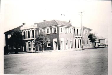
 City of Ballarat Libraries
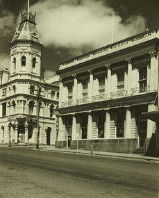
Photograph, Craig's Royal Hotel & Union Bank of Australia Building, Lydiard Street South, Ballarat
An image from the Herbert Richmond collection, gifted in 1982 to the Ballarat Library. The collection contains approximately 200 photographs of Ballarat and district in the 1940s, 50s and 60s, as well as photo albums, glass negatives and other memorabilia. Herb Richmond was a keen photographer, a foundation member and a life member of the Ballarat Camera Club, and a photographer with the Ballarat Courier during the 1940s. The Ballarat Camera Club named an annual award after him. Mr Richmond died in 1981 aged 79. These images were digitally re-photographed by members of the Ballarat Camera Club in September 2006. The first site to be sold in Ballarat, where in 1853 Thomas Bath erected a timber building for use as a hotel. Parts of the present hotel date from 1862, when Walter Craig was owner. The hotel is associated with many historic figures, and no other hotel in Victoria has such an interesting succession of buildings and additions. The former Union Bank of Australia building was designed by Leonard Terry, the renowned bank architect, and was erected in 1863-4.lydiard street south, craig's royal hotel, union bank of australia, terry, leonard -
 Marysville & District Historical Society
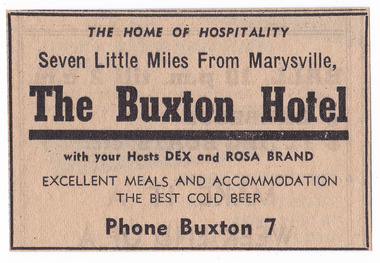
Newspaper (Item) - Newspaper advertisement, BUXTON HOTEL, 1950s
A newspaper advertisement regarding the Buxton Hotel in Buxton. Dex and Rosa Brand were the hosts at the hotel at the time of the advertisement. They, along with their children, Colin and Helen, ran the hotel in the 1950s. The Buxton Hotel was built by William Burchall, probably in the late 1870s. The first owner, who also had land locally, was Frederick Nichols (1833-1904). The Buxton Hotel is located directly opposite the General Store. It was fronted with two huge oak trees and bordered and backed by large pine trees. It was a weatherboard structure with a painted corrugated iron roof. Old split wood shingles were covered by corrugated iron, which overlaid the shingles to make the roof watertight. The wooden shingles date back to the 1850s.A newspaper advertisement regarding the Buxton Hotel in Buxton.buxton, victoria, australia, buxton hotel, accommodation, willam burchall, frederick nichols, advertisement, colin brand, helen brand, dex brand, rosa brand -
 Buninyong & District Historical Society
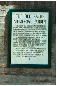
Photograph - Original Photograph, Old Baths Memorial Garden Plaque, 1993
Colour photograph of Plaque on walls of old Buninyong BathsThe plaque outlines the history of the baths constructed in the 1870's as a water source, their redesign by C.C.P. Wilson and reconstruction by WW1 soldiers and their continuing role within the Buninyong Community.Colour photograph of the Plaque on the wall of old Buninyong Swimming Pool giving history of the Old Baths in Buninyong Botanical GardensOld swimming pool, Buninyong gardens built c 1918, restored 1993-94. Photo taken Jan 1995returned soldiers ww1, buninyong gardens, memorial gardens, buninyong baths, c.c.p. wilson -
Ballarat and District Irish Association
Photograph - digital, Clare Gervasoni, Ballaarat Old Cemetery Headstone for James Noonan and Mary Noonan, 01/12/2013
Digital photograph of a Ballaarat Old Cemetery Headstone for James Noonan and Mary Noonan. Mary Noonan was from Spencil Hill, County Clare, Ireland. SHe died on 06 March 1883 aged 39. James Noonan died in July 1889.ballarat irish, ballaarat old cemetery, headstone, noonan, james noonan, mary noonan, spencil hill -
Tatura Irrigation & Wartime Camps Museum
Photograph - copy, D. Clark, Royal Visit 1954, 1989 copy
Copy of photograph of Shire President, Cr Brewer and Mrs Brewer fare welling the Queen and Duke of Edinburgh at Tatura Railway Station. Royal Visit 1954.Black and white copy of photograph of Royal couple boarding Royal train at Tatura Railway Station 1954.on back: Royal Visit 1954royal visit -
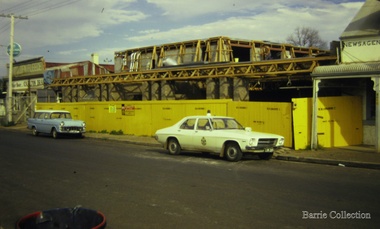 Melton City Libraries
Photograph, Construction of the Golden Fleece Hotel, 1973
Demolition of the old and rebuilding the new hotel.local architecture -
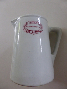 Warrnambool and District Historical Society Inc.
Jug, Lynch's Criterion Hotel Warrnambool, 1920s
This china jug has been made in England by Grindley Hotel Ware. The Grindley company that manufactured earthenware and ironstone items was founded in 1880 by William Grindley and was initially based in Tunstall, Stoke-on-Trent, England. The jug has had a red stamp added so that it could be used at the Criterion Hotel in Warrnambool and identified as the hotel property. The jug was used during the licenseeship of Theresa Lynch. The Criterion Hotel was situated on the western side of Kepler Street near Lava Street, Warrnambool. It opened in 1872 with the first licensee, John Tate. In the 1920s there were extensive renovations to the hotel in the Art Deco style. Theresa Lynch was the licensee from 1919 to 1926. In 1922 she bought the hotel and sold it to Harry McGennan in 1926. In 2006 the Criterion Hotel was closed and it was partially destroyed by fire in 2010 and later completely demolished. This jug is of interest as a 1920s souvenir of the Criterion Hotel, Warrnambool that closed in 2006. This hotel was a prominent one in Warrnambool, known in the 1990s for its promotion of live rock music. This is a white china jug with a circular base slightly tapering to an open top with a spout and handle. On the side of the jug there is a red stamp in the shape of a belt with red lettering. The base has a crown image and the maker’s name.‘Lynch’s Criterion Hotel Warrnambool’ Grindley Hotel Ware, Made in England, Patent’. criterion hotel, warrnambool, theresa lynch -
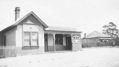 Ringwood and District Historical Society
Photograph, Coach and Horses Hotel, Ringwood. 1909-1939, taken in 1939
Black and white photograph of Coach and Horses Hotel.Typed below photograph, "Coach and Horses Hotel. 1909-1939". -
 Hume City Civic Collection
Photograph, 1952
B/W photograph of the Royal Hotel, Sunbury 1952Printed by hand on back: ROYAL HOTEL, SUNBURY. 1952royal hotel, sunbury, hotels, buildings, 1950s, george evans collection -
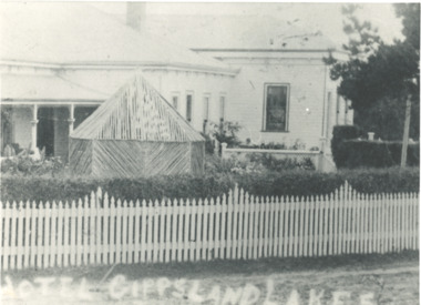 Lakes Entrance Historical Society
Photograph, Club Hotel, Lakes Entrance Victoria, 1901 c
Black and white photograph of east end of Club Hotel showing garden summer house and picket fence in front, Lakes Entrance VictoriaHotel Gippsland Lakeshotels, accommodation -
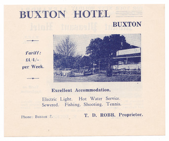 Marysville & District Historical Society
Ephemera (Item) - Advertisement, BUXTON HOTEL, Unknown
An advertisement regarding the Buxton Hotel in Buxton. Thomas David Robb (1886-1967), was the licensee at the time of the photograph. He, and his wife Alice May Evans, ran the Buxton Hotel for 25 years. The Buxton Hotel was built by William Burchall, probably in the late 1870s. The first owner, who also had land locally, was Frederick Nichols (1833-1904). The Buxton Hotel is located directly opposite the General Store. It was fronted with two huge oak trees and bordered and backed by large pine trees. It was a weatherboard structure with a painted corrugated iron roof. Old split wood shingles were covered by corrugated iron, which overlaid the shingles to make the roof watertight. The wooden shingles date back to the 1850s.An advertisement regarding the Buxton Hotel in Buxton.buxton, victoria, australia, buxton hotel, thomas david robb, alice may evans, accommodation, willam burchall, frederick nichols, advertisement -
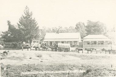 Lakes Entrance Historical Society
Photograph - Hotel Ensay Victoria
Black and white copy of photograph of hotel between Bruthen and Omeo with two horse drawn wagons in front, each wagon drawn by seven horses. Hotel on left with large pine tree and, residence on right, Ensay Victoria. Also an identical copyThe Ensay Hotel on Bairnsdale - Omeo Roadhotels, businesses -
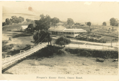 Lakes Entrance Historical Society
Postcard - Fregons Hotel Ensay Victoria
Black and white postcard of Fregons Hotel with suspension bridge across stream opposite, Ensay VictoriaFregon's Ensay Hotel Omeo Roadhotels, businesses -
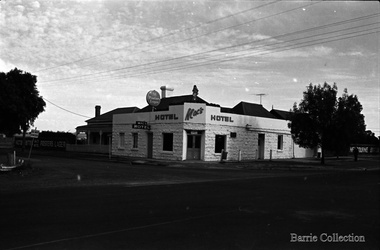 Melton City Libraries
Photograph, Mac Hotel, 1970
The Minns’ Hotel was originally a butcher shop, before owner George Minns transformed it into a hotel.Mac’s Hotel (formerly Minns Hotel until 1911), High Street Meltonlocal architecture -
 Ballarat Clarendon College
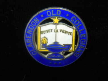
Badge, Clarendon Old Collegians
The Clarendon Old Collegians Association existed from very early times in the school history and was a singificant controbutor to school socail capacity and infrastructure. The OC's regularly donated funds and purchases to special projects. Sections of the society met in different geographic areas, such as Melbourne or the Wimmera. Three circular enamel brooches featuring outer circle in royal blue with lettering enclosing features of school crest - open book in white with gold border, royal blue lamp with gold flame at base of book and gold star at top of bookLettering around border: CLARENDON OLD COLLEGIANSclarendon-presbyterian-ladies-college, clarendon-old-collegians