Showing 227 items
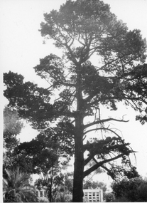
matching paddock tree
-
 Kew Historical Society Inc
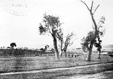
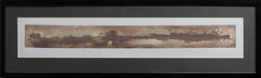
Photograph, J F C Farquhar, A View in Studley Park Road, 1891
At the beginning of the 1890s, the Kew businessman and Town Councillor, Henry Kellett, commissioned J.F.C. Farquhar to photograph scenes of Kew. These scenes included panoramas as well as pastoral scenes. The resulting set of twelve photographs was assembled in an album, Kew Where We Live, from which customers could select images for purchase.The preamble to the album describes that the photographs used the ‘argentic bromide’ process, now more commonly known as the gelatine silver process. This form of dry plate photography allowed for the negatives to be kept for weeks before processing, hence its value in landscape photography. The resulting images were considered to be finely grained and everlasting. Evidence of the success of Henry Kellett’s venture can be seen today, in that some of the photographs are held in national collections.It is believed that the Kew Historical Society’s copy of the Kellett album is unique and that the photographs in the book were the first copies taken from the original plates. It is the first and most important series of images produced about Kew. The individual images have proved essential in identifying buildings and places of heritage value in the district.This is the earliest known photograph of the exterior of Byram (later Tara Hall). It shows the original red brick fence, its asymmetrical gate and gateposts, with a large terra cotta gargoyle surmounting the higher of the two. The architect, Edward Kilburn designed Byram in the Arts & Crafts style for the industrialist George Ramsden. Construction began in 1888 and was reputed to have lasted three years. The mansion had frontages to Studley Park Road and Stevenson Street, including gardens laid out with great taste, including pleasure grounds, tennis lawn, fruit and flower garden, and paddock. The size of many of the trees in the garden indicate that many survived from the garden of Clifton Villa, the previous single-storeyed house built on the site by the Stevenson brothers. Byram had views to Melbourne and Port Phillip Bay. The house was demolished in 1960, despite opposition from the National Trust (Victoria), and its gardens subdivided into residential allotments.A View in Studley Park Roadkew illustrated, kew where we live, photographic books, henry kellett, byram, tara hall, goathlands -
 Kew Historical Society Inc
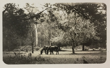
Photograph - Horses grazing near Cockatoo, c.1926
Henry Beater Christian (1886-1962) , was a descendant of one of the earliest settler families in Kew. Employed at the Kew Asylum as a 'public servant', he was a skilled amateur photographer, photographing numerous scenes in Kew and on his travels around Victoria. The majority of his photographs date from 1916 to 1929. His finest photographs are housed in two photograph albums. Digital copy of a photograph from page 28 of the 47-page photograph album containing 261 gelatinous silver images, loaned by Diane Washfold with permission given to digitise and hold a copy in our collection. John Chapman has written in 'Bushwalking Clubs - A Brief History', about the establishment in Victoria of the first bushwalking club in 1888, and the popularisation of bushwalking during the interwar period. Henry Christian's 'walks' appear to have been undertaken solely or with a companion/s. This photo was taken on a trip between Cockatoo and Gembrook in Victoria and shows two horses grazing in a paddock to the left of an 'exotic' tree in full bloom. "Cockatoo & Gembrook [illegible]henry beater christian (1886-1962), landscape photography, christian-washfold collection, photograph albums, bushwalking, cockatoo, gembrook -
 Kew Historical Society Inc
Photograph - Civic event in Stradbroke Park, 1976
Stradbroke Park. Extent: Kilby Road to Harp Road at Burke Road. Historical Documentation: 1851 - Portion 91 purchased by Edward Glynn; 1888 - The Harp of Erin Estate (which included Section 91) offered for sale; 1896 - The area now known as Stradbroke Park was bisected by a creek that flowed from the Yarra via Hay's Paddock (q.v.) and extended through to Burke Road; 1943 - W.D. Birrell, Town Clerk of Kew, proposed that the creek be filled and a reserve created; 1954 - Entire area designated as 'open space' and named 'Stradbroke Park'. The line of the creek that ran through the Park created a further reserve on the north side of High Street, now known as 'Harrison Reserve'. Existing Condition: The park is largely of mown grass that has mature trees set into it It is possible that a number of these are remnant of the original vegetation, while there are also a number of exotic trees introduced, particularly at the northern end of the park. The southern end is dominated by playing fields. (Source: Sanderson, P 1988. Kew Conservation Study)Colour photographic positive (with colour degradation) of sporting teams at a civic event in Stradbroke Park in Kew East in May 1976. The event was officiated by the Mayor of Kew, Cr Alan Hutchinson. Sporting teams in uniform included: footballers, athletes, cricketers, hockey players. Stradbroke Park is situated on the western boundary of Kew at Burke and Harp Roads.stradbroke park, cr alan hutchinson, team sports -- kew (vic.) -
 Kew Historical Society Inc
Photograph - Civic event in Stradbroke Park, 1976
Stradbroke Park. Extent: Kilby Road to Harp Road at Burke Road. Historical Documentation: 1851 - Portion 91 purchased by Edward Glynn; 1888 - The Harp of Erin Estate (which included Section 91) offered for sale; 1896 - The area now known as Stradbroke Park was bisected by a creek that flowed from the Yarra via Hay's Paddock (q.v.) and extended through to Burke Road; 1943 - W.D. Birrell, Town Clerk of Kew, proposed that the creek be filled and a reserve created; 1954 - Entire area designated as 'open space' and named 'Stradbroke Park'. The line of the creek that ran through the Park created a further reserve on the north side of High Street, now known as 'Harrison Reserve'. Existing Condition: The park is largely of mown grass that has mature trees set into it It is possible that a number of these are remnant of the original vegetation, while there are also a number of exotic trees introduced, particularly at the northern end of the park. The southern end is dominated by playing fields. (Source: Sanderson, P 1988. Kew Conservation Study)Colour photographic positive (with colour degradation) of sporting teams at a civic event in Stradbroke Park in Kew East in May 1976. The event was officiated by the Mayor of Kew, Cr Alan Hutchinson. Stradbroke Park is situated on the western boundary of Kew and bordered by Burke and Harp Roads.stradbroke park, cr alan hutchinson, team sports -- kew (vic.) -
 Sunbury Family History and Heritage Society Inc.
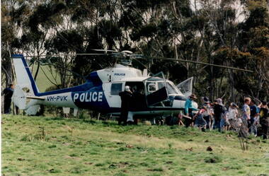
Photograph, Police Helicopter, c Early 1990s
After the police spoke to the students from Bulla Primary School and they had all had a chance to look over the rescue helicopter, the children were taken a safe distance away from the craft and watched it take off.A non-digital coloured photograph of a group of children lined up and looking at a police helicopter in a paddock. There are a number of tall gum trees in the background. police helicopters, policemen, bulla primary schooil -
 Surrey Hills Historical Society Collection
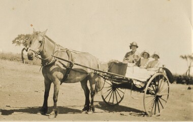
Photograph, Gwen and Beryl Mair and Mrs Jarman in a jinker, Derrinallum, c1927, c1927
David Miller (Dave) Mair (1879-1938) married Lily Vipond Deakin (1890-1945) in 1910. They had 5 children: Geoffrey David (1913-1970), Beryl (1916-1976), Gwynneth (1917-1997), Isabel Lillian (1921-1997) and Shirley Inez (1928-1968). Personal communication from Laurie Newton, Beryl's daughter: Dave and Lily initially lived in East Melbourne after they married. Dave walked across the gardens to work at the MCG. He never drove or owned a car. Geoffrey, Beryl and Gwynneth were born in East Melbourne. They subsequently moved to Louise Avenue, Mont Albert and Isabel may have been born while they were there. Later they purchased 20 Barton Street, Mont Albert. Shirley was born after they moved to Barton Street. Electoral roll details: 1919 1922 24 Louise Avenue, Mont Albert 1924 20 Barton Street, Mont Albert Dave Mair was a very keen sportsman. This is part of a large donation of material from the Deakin, Mair and Young families. The Deakin, Mair and Young families had many connections with Mont Albert and Surrey Hills.A sepia photo of a woman and 2 girls in a jinker. They are all wearing brimmed hats as if going on an outing. Apart from a couple of straggly trees in the background along what may be a boundary or paddock fence, the surroundings look very bare.In blue biro: " Gwen / Beryl / Mrs Jarman / Derrinallum" Thought to be Beryl Mair's handwriting. Photographic process stamp "C 311" "KODAK PRINT" in black. beryl mair, gwen mair, mrs jarman, farms, children, horse-drawn vehicles -
 Surrey Hills Historical Society Collection
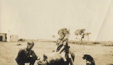
Photograph, Gwen and Beryl Mair with Mr Jarman, Derrinallum, c1927, c1927
David Miller (Dave) Mair (1879-1938) married Lily Vipond Deakin (1890-1945) in 1910. They had 5 children: Geoffrey David (1913-1970), Beryl (1916-1976), Gwynneth (1917-1997), Isabel Lillian (1921-1997) and Shirley Inez (1928-1968). Personal communication from Laurie Newton, Beryl's daughter: Dave and Lily initially lived in East Melbourne after they married. Dave walked across the gardens to work at the MCG. He never drove or owned a car. Geoffrey, Beryl and Gwynneth were born in East Melbourne. They subsequently moved to Louise Avenue, Mont Albert and Isabel may have been born while they were there. Later they purchased 20 Barton Street, Mont Albert. Shirley was born after they moved to Barton Street. Electoral roll details: 1919 1922 24 Louise Avenue, Mont Albert 1924 20 Barton Street, Mont Albert Dave Mair was a very keen sportsman. This is part of a large donation of material from the Deakin, Mair and Young families. The Deakin, Mair and Young families had many connections with Mont Albert and Surrey Hills.A sepia photo of 2 girls on the back of a pig, which is being lightly held by a man, squatting beside the animal. A cattle dog sits nearby. In the background are some straggly trees along what may be a boundary or paddock fence, apart from which the surroundings look very bare. Off to the LHS in the background is farm shedding.In black ink: "Off for a joy ride / B. Mair / 20 Barton St / SUrrey Hills / E10." - thought to be in Lily Mair's handwriting. In blue biro: " Gwen Beryl (IN FRONT in lead pencil) / Mr Jarman / Derrinallum" Thought to be Beryl Mair's handwriting. "KODAK PRINT" in black. beryl mair, gwen mair, mr jarman, farms, children, derrinallum -
 Surrey Hills Historical Society Collection
Photograph, Chatham State School Grade 1 1927, 1927
Chatham School, located in Weybridge Street Surrey Hills, was opened on 1 August 1927 following pressure from local residents as nearby schools (Balwyn, Mont Albert & Surrey Hills) were all over-crowded. This followed a surge in development following WW1. Land in surrounding streets was sub-divided. This included part of John Butler Maling (Jnr)'s small farm bounded by Banool Road, Wharton Road, Weybridge Street and Whitehorse Road. An area surrounding his home, 'The Willows' was retained and not sold until after he died in 1931. leased by Mr John Butler Maling in 1861. Three acres of his land were purchased by the Education Department. Some of the early students have referred to Chatham’s land as Mr Maling’s bull paddock. Some of the original yellow box trees remain on the property. The most significant of these is now called the Friendship Tree. On 1 August 1927 212 students were enrolled; Ralph Rae was one of these. The school was official opened on 15th February 1928. The school number is 4314. A black and white photograph of a group of 39 Grade 1 students from Chatham State School.1927, schools, chatham state school, clothing and dress, primary schools, john butler maling (jnr), ralph rae (mr) -
 Surrey Hills Historical Society Collection
Photograph, Stan Smith c1916, 1916
Stan Smith, then of 3 Vincent Street, on his father’s horse in Mont Albert Road in about 1916. Mr Charles Smith was an insurance officer whose area was from Burke to Elgar Road; he used his phaeton for transport. Oral testimony - Stan Smith: “We had a stable for the horse near the house and a yard but we tethered the horse at the end of a long rope on paddocks in Empress Road- the area from Mont Albert Road to Guildford Road. We used to put in an iron peg. Some horses were tethered similarly in various paddocks but not a lot of people had horses by this time. A few cows grazed around them.” The picket fence on the left and the trees were those of ‘Monserrat’ – the Parer home, now entered from 26a Wandsworth Road as the Mont Albert Road frontage was sold off many years ago. A black and white photograph of a young boy on a horse. There are a number of well established trees in the background and a fence. The young boy is identified on the back of the small photograph as "Stan" on "Bob" the horse.On back of small photograph: "Stan on Bob / Mont Albert Rd / Surrey Hills 1916 / In front of / Mr Parers home"(mr) stan smith, vincent street, surrey hills, empress road, wandsworth road, house names, parer home, (mr) charles smith, 'monserrat' -
 Surrey Hills Historical Society Collection
Photograph, Chatham State School Grade 5 1931, 1931
Chatham School, located in Weybridge Street Surrey Hills, was opened on 1 August 1927 following pressure from local residents as nearby schools (Balwyn, Mont Albert & Surrey Hills) were all over-crowded. This followed a surge in development following WW1. Land in surrounding streets was sub-divided. This included part of John Butler Maling (Jnr)'s small farm bounded by Banool Road, Wharton Road, Weybridge Street and Whitehorse Road. An area surrounding his home, 'The Willows' was retained and not sold until after he died in 1931. leased by Mr John Butler Maling in 1861. Three acres of his land were purchased by the Education Department. Some of the early students have referred to Chatham’s land as Mr Maling’s bull paddock. Some of the original yellow box trees remain on the property. The most significant of these is now called the Friendship Tree. On 1 August 1927 212 students were enrolled; Ralph Rae was one of these. The school was official opened on 15th February 1928. The school number is 4314. A black and white photograph of a group of 51 Grade 5 students from Chatham State School.schools, chatham state school, clothing and dress, primary schools, john butler maling (jnr), ralph rae (mr) -
 Surrey Hills Historical Society Collection
Photograph, Chatham State School Grade 2 1928, 1931
Chatham School, located in Weybridge Street Surrey Hills, was opened on 1 August 1927 following pressure from local residents as nearby schools (Balwyn, Mont Albert & Surrey Hills) were all over-crowded. This followed a surge in development following WW1. Land in surrounding streets was sub-divided. This included part of John Butler Maling (Jnr)'s small farm bounded by Banool Road, Wharton Road, Weybridge Street and Whitehorse Road. An area surrounding his home, 'The Willows' was retained and not sold until after he died in 1931. leased by Mr John Butler Maling in 1861. Three acres of his land were purchased by the Education Department. Some of the early students have referred to Chatham’s land as Mr Maling’s bull paddock. Some of the original yellow box trees remain on the property. The most significant of these is now called the Friendship Tree. On 1 August 1927 212 students were enrolled; Ralph Rae was one of these. The school was official opened on 15th February 1928. The school number is 4314. Front row centre is Jocelyn Cerini who married Ken Hall, another Chatham student. A black and white photograph of a group of Grade 2 female students from Chatham State School. They are dressed in white.schools, chatham state school, clothing and dress, primary schools, john butler maling (jnr), ralph rae (mr), jocelyn cerini (miss), jocelyn hall (mrs) -
 Surrey Hills Historical Society Collection
Photograph, Surrey Hills Golf Club - looking towards Doncaster, 1902, 1902
Reproduced by permission of Mr John Arnold from his book: "The Riversdale Golf Club - a history, 1892-1977." Copyright to book: Riversdale Golf Club. Surrey Hills Golf Club operated from 1892-1908 then moved and became Riversdale Golf Club. The game was played across paddocks from Trafalgar Street, Mont Albert to Whitehorse Road and down Victoria Crescent to where Box Hill TAFE is now located in Elgar Road. There were problems with cows eating the tee flags! The clubhouse still exists as 30 Trafalgar Street.This image is important for reference to the landscape and vegetation prior to urbanisation.Black and white photo in the foreground of which is a path running diagonally from left to right. Behind are 5 mature trees whose condition is not vigourous (showing signs of die-back). Several figures are beneath the trees, behind which is a post-and-wire fence, paddocks and distant houses. There is the shadow of a stamp in the top LH corner, suggestive of this having been copied from an earlier image.Caption: "Top: Looking towards Doncaster from the links in 1902."sports grounds, surrey hills golf club, riversdale golf club, john arnold -
 Surrey Hills Historical Society Collection
Photograph, Streetscape near the corner of Victoria Crescent and Hotham Street, Surrey Hills
Prior to subdivision for housing this area was paddocks used for grazing of cattle and used as part of the course in the early days of the Surrey Hills Golf Club. Reproduced by permission of Mr John Arnold from his book: "The Riversdale Golf Club - a history, 1892-1977." Copyright to book: Riversdale Golf Club. Surrey Hills Golf Club operated from 1892-1908 then moved and became Riversdale Golf Club. The game was played across paddocks from Trafalgar Street, Mont Albert to Whitehorse Road and down Victoria Crescent to where Box Hill TAFE is now located in Elgar Road. There were problems with cows eating the tee flags! The clubhouse still exists as 30 Trafalgar Street.Black and white photo taken from the centre of a bitumen road which is flanked by bluestone guttering. Nature strips, drive cross-overs and house fences are shown. Trees on the RHS nature strip are pollarded to avoid overhead power and telephone lines. There houses in the background."Bottom: The same view today taken from the intersection of Victoria Crescent and Hotham Street, Surrey Hills."surrey hills golf club, hotham street, victoria crescent, riversdale golf club, surrey hills, john arnold -
 Surrey Hills Historical Society Collection
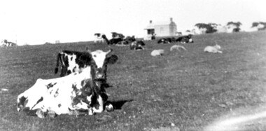
Photograph, Norman Carter, Part of Black's dairy farm in Mont Albert in the 1920s, 1920s
Photo is likely to have been taken pre-1924 when the land was subdivided. Donor information is that this was taken from a home in Churchill Street, Mont Albert; it would be looking south towards Mont Albert Road. Black's dairy farm occupied the area just east of Hamilton Street to near Elgar Road. It was subdivided into 88 house allotments along Churchill Street, Bruce Street, Black Street, Proudfoot Street and View Street. The solicitors were Proudfoot & Horton, 360 Collins Street; estate agents were Duncan & Weller, 29 Queen Street. The real estate subdivision notice on the SLV website states that Neil Black had been the owner for 50 years. To date no trace of a Neil Black has been found. Box Hill rate books simply give BLACK as the owner in 1877 (no first name); the entry for 1878-1884 states Robert Black. The 1909 electoral roll has entries for Mont Albert Road for Robert Black (farmer), Thomas Black (carter) & Elizabeth Black (HD). The 1912 electoral roll has entries for Mont Albert Road for Robert Black (farmer), Thomas Black (labourer), John Arthur Black (carter) & Elizabeth Black (HD). Robert Black died in 1920 (b. 1836) and is buried in Box Hill Cemetery (CE-*-0057). His parents were John and Margaret Black. He married Lizzie Foley in 1878. She was the daughter of Margaret & John Foley, born in 1859. She died in 1902 aged 43 years and is probably buried in the same grave, although the cemetery records record her age as 0 years. Children: 1. James Hughbert (1880-1954) 2. John Arthur (1881-1959) 3. Alice (1882-1883) - died aged 6 months 4. Laura Elizabeth (1883-1951) 5. Thomas (1885-1965) 6. Isabella (1887-1963) 7. Eleanor (1889-1963) 8. Ada Maud (1890-1968) 9. Robert (1892-1930). BDM Victoria states places of birth as Box Hill, Surrey Hills or Mont Albert. Many of the family are buried in Box Hill Cemetery. None of the girls appear to have married. Communication from a descendant of John Arthur Black gives the following: "John Arthur Black, son of Robert & Lizzie Foley, married Gladys Anne Layton had 4 children, Robert, Elenore, Marion (Follett) & Annie; they had farm on Stud Road, Dandenong where they milked 30 cows that he retired to after being a earth-moving contractor with draft horses and dug irrigation ditches around Shepparton." This is important as documentation of the area's early farming land use.Black and white photo of a paddock with cows and sheep grazing. On the horizon is a simple cottage with a small veranda and 2 chimneys and scattered trees.black's dairy farm, dairying, farms, churchill street, black street, proudfoot street, bruce street, view street, neil black, proudfoot & horton, duncan & weller, robert black, lizzie black, lizzie foley, james hubert black, john arthur black, alice black, laura elizabeth black, thomas black, isabella black, eleanor black, ada maud black, robert black jnr, box hill cemetery -
 National Wool Museum
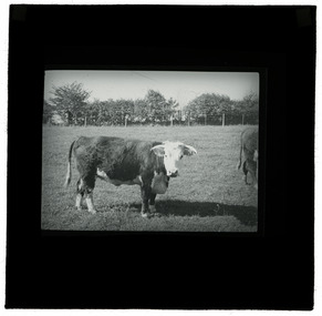
Photograph - Cow, J W Allen, 1900 - 1940
This item is part of a collection of twenty black and white glass lantern slides previously housed together in an old cardboard box. [8611 - 8630] The slides are part of a greater collection of around forty three black and white glass lantern slides, along with other photographs and photo albums related to this collection. This item is associated with the New South Wales Graziers Association world tour of merino sheep 1928/9. The slides were possibly used as supporting material in presentations made by J W Allen when on tour.Black and white glass lantern slide with paper edging depicting a cow standing in a paddock with a fence and trees in the background.new south wales graziers association, travel, cattle, agriculture, j w allen, photography, glass lantern slide -
 National Wool Museum
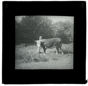
Photograph - Cow, J W Allen, 1900 - 1940
This item is part of a collection of twenty black and white glass lantern slides previously housed together in an old cardboard box. [8611 - 8630] The slides are part of a greater collection of around forty three black and white glass lantern slides, along with other photographs and photo albums related to this collection. This item is associated with the New South Wales Graziers Association world tour of merino sheep 1928/9. The slides were possibly used as supporting material in presentations made by J W Allen when on tour.Black and white glass lantern slide with paper edging depicting a cow standing in a paddock with a fence and trees in the background.new south wales graziers association, travel, cattle, agriculture, j w allen, photography, glass lantern slide -
 Federation University Art Collection
Work on paper - Collograph, 1) 'The Trees' .2) 'Them Paddocks' by Nadine Sherer, 1999
... landscapes. .1) 'The Trees' .2) 'Them Paddocks' by Nadine Sherer Work ...This item is part of the Federation University Art Collection. The Art Collection features over 2000 works and was listed as a 'Ballarat Treasure' in 2007.Two framed collographs depicting abstracted landscapes.art, artwork, printmaking, collograph, alumni, school of business collection, landscape -
 University of Melbourne, Burnley Campus Archives
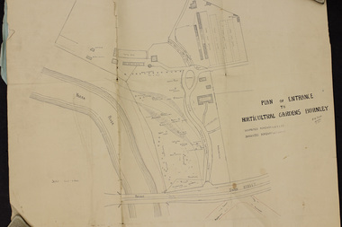
Plan, Plan of Entrance to Horticultural Gardens Burnley, 1932
Copy of plan photographed at the Public Records Office Victoria. (1) Hand drawn plan signed by A.W. Jessep 8/12/32 with 'Suspected Roadway' and ' Suggested Roadway'. Scale 1 inch - 1 chain. Trees on East side named. (2) Memorandum to The Agricultural Superintendent dated 08.12.1932 'Re Proposed Boulevard Along the River Yarra' from the Principal A.W. Jessep. Plan had been to put road through the Lagoon Paddock and he suggested the route outside the Burnley College grounds.prov, burnley gardens, a.w. jessep -
 University of Melbourne, Burnley Campus Archives
Photograph - Black and white print, iii, 1925-1955
... Lemon tree with the cow paddock in the background.... Boulevard Richmond melbourne lemon tree cow paddock Lemon tree ...Lemon tree with the cow paddock in the background.lemon tree, cow, paddock -
 University of Melbourne, Burnley Campus Archives
Album, Sandra Pullman, National Estate/Heritage Register Photographs, 2001
Photograph Album sent in with the National Estate/Heritage Register by Sandi Pullman. (1) Old car park (Bull Paddock) with Cork Oak. (2) Main Building front steps. (3) Main Building with Magnolia grandiflora. (4)View of Luffmann Ponds and old willow. (5) View of Ginkgo and Emily Gibson bed. (6) Looking between Emily Gibson beds to English Oak. (7) Summer House. (8) Luffmann Ponds. (9) Bergenia Walk with conifers. (10) View of Pencil Pines around entrance to Sunken garden. (11) Luffmann Ponds and Pinus canariensis. (12) View of entrance to Sunken garden. (13-14) Sunken garden. (15) Original terracing at entrance to Shady Walk. (16) Pears in blossom in Field Station. (17) Agathis robusta from the Herb Garden. (18) Ellis Stones Rock garden newly replanted. (19) james Hitchmough Grasslands. (20) Elm tree with Dairy in the background. (21) Original Red Gum in james Hitchmough Grasslands. (22) Kath Deery Native garden. (23-24) Rose Garden. (25) Sequoiadendron giganteum.national estate, heritage register, sandi pullman, sandra pullman, bull paddock, cork oak, magnolia, luffmann ponds, willow, ginkgo, emily gibson bed, english oak, summer house, bergenia walk, conifers, pencil pines, sunken garden, pinus canariensis, shady walk, pears, blossoms, field station, agathis robusta, herb garden, ellis stones rock garden, james hitchmough grasslands, elm tree, dairy, red gum, kath deery native garden, rose garden, sequoiadendron giganteum. -
 University of Melbourne, Burnley Campus Archives
Album - Black and white and colour slides, Burnley Views, 1947-1955
Contributor: T.H. KneenCardboard box of 108 35mm glass slides in metal frames made by "Gnome." Box labelled "Burnley Gardens Slides." Also 16 unused slides (1) Swan Street entrance c. (2) Orchid? b/w. (3) Nursery b/w. (4) Pasture area with man working b/w. (5) Draught horse working in the Orchard b/w. (6) Crop of corn in the Orchard c. (7) Magnolia c. (Magnolia x soulangeana). (8) Display of orange flowers c. (9) Lemon tree in the Orchard c. (10) Sign advertising 'Fruit Tree Pruning Demonstarion Sat. 2nd July (1949) c. (11) Jersey cow c. (12) Rock Point c. (13) Dahlias in the Orchard c. (14) Foundation Stone '28th August, 1946' c. (15) Felled Cypress tree 1951 b/w. (16) School truck in front of glasshouses and cacti b/w. (17)Administration Building completed but surrounded by rubble C.1949 c. (18) Plant Research Institute c. (19) Inside a glasshouse. c. (20) Administration Building c. (21) Group of female students dressed up for a function c. (22) Solenostemon (Syn. Coleus) in a glasshouse. (23, 24)Stock Matthiola incana. (25) Blossom in the Orchard c. (26) Orchard c. (27) Picking fruit in the Orchard c. (28) 2 female students holdong large bunches of poppies c. (29) Flowers growing in the Orchard c. (30) House - not Burnley c. (31) Students on an excursion c. (32) Staff member with Gladioli c. (33) Garden view - not Burnley? c. (34) Administration Building c. (35) Roses c. (36) Flowers in the Orchard c. (37) Draught horse working in the Orchard c. (38) Staff member amongst flowers in the Orchard c. (39) Garden view c. ((40) Blossom in the Orchard c. (41) Orchard c. (42) Flowers inside glasshouse c. (43) Mesembryanthemums in pots possibly in the nursery c. (44) Tree b/w. (45) Garden bed c. (46) Sign, 'Agrostology Branch, pasture Plant Research Field,' c. (47) Path to Principal's Residence c. (48) Irrigation in the Orchard b/w. (49) Cactus flowers b/w. (50) Garden view with T.H. Kneen children playing c. (51) (52) Cinerarias (now Pericallis x hybrida) in pots c. (53) Temporary building where the Grey Garden is now b/w. (54) Garden view b/w. (55) Unknown building b/w. (56) Person pruning in the Orchard c. (57) Students working in the Orchard c. (58) Swan Street with recently completed rock wall constructed by the Public Works Department b/w. (59) Lagoon paddock b/w. (60,62) Pavilion and new Administration Building before the Pavilion was removed b/w. (61) As (60) but viewed from a different direction c. (63) Plant c. (64) View through a window on the stairs in the Administration Building c. (65) Plant c. (66) Garden view of trees c. (67) Garden View b/w. (68) Blossom tree c. (69 )Garden view along path to Principal's Residence c. (70) Lagoon Paddock c. (71) Lagoon Paddock with cows b/w. (72) Inside a glasshouse b/w. (73) Entrance sign- Department of Agriculture Burnley Gardens, School of Horticulture & Primary Agriculture, Plant Research laboratory, Agrostology Branch, Fruit Preserving Branch c. (74) Plant Research Laboratory b/w. (75) Students on an excursion c. (76) Glasshouses b/w. (77) Garden view b/w. (78) Kniphophia c. (79) Hibiscus c. (80) Garden view c. (81) Dairy, Silo and dog b/w. (82) Irrigation in then Orchard b/w. (83) Garden view with magnolia c. (84) Flower plots in the Orchard c. (85) Pruning demonstration b/w. (86) Administration Building under construction c. (87) Rock Point c. (88) Mrs Kneen and Magnolia c. (89) Glasshouses c. (90) Sequoia sempervirens b/w. (91) Inside Administration Building c. (92) Luffmann Ponds b/w. (93) Sequoia sempervirend, Mrs Kneen and child c. (94) Garden bed in front of Sequoian sempervirens c. (95) Principals Residence b/w. (96) Poultry pens b/w. 1947 (97) Principals Residence b/w. (98) Student picking fruit from netted tree b/w. (99) Rock Point and Long Border c. (100) Administration Building under construction c. (101) Greenhouse b/w. (102) Rock Point c. (103) Flowers in the Orchard c. (104) Waterlilies in the Pond c. (105) Blossom tree c. (106) Hilda Kirkhope Rockery c. (107) Long Border c. (108) Plant Research Institute with flower border along drive c.burnley gardens, flower, nursery, pasture, draught horse, orchard, crops, magnolia, chicken coops, egg laying competition -
 University of Melbourne, Burnley Campus Archives
Photograph - Black and white print, Miscellaneous Photographs
... Boulevard Richmond melbourne trees garden views fruit tree pruning ...trees, garden views, fruit tree pruning, lagoon paddock, orchard, principals residence, pinus canariensis, sequoia sempervirens, pinus radiata, butia capitata, emily gibson bed -
 University of Melbourne, Burnley Campus Archives
Slide - 35mm Colour slides, Miscellaneous Burnley, 1968-1974
1. Entrance Swan Street, Richmond Oct 68. 2. Greenhouse equipment Nov 68. 3. "J. Firth" Nov 68. 5. "B. Gdns Tech Block" Oct 69. 4, 6, 7. Lagoon Paddock. 6, 7. April 1969 Garden views 8, 9 May 69 Garden views. 10. "Shepherds Moorooduc" Feb 70. 11. "B. Gdns Principals Residence", 12. "B. Gdns Oak Tree" Oct 70. 13. "Strawberry Over Plastic Grampians Sep 72" Oct 72. 14. "Mildura School Bus", 15. "Irymple. R.S.I. Thornton" Jul 73. 16. "Citrus (Pruned) Sept", 17. "Student Plots 1974" Nov 74.tech block, garden views, principals residence, oak tree, school bus, student plots, swan street entrance, greenhouse equipment, j firth, shepherds moorooduc, strawberries grampians, mildura camp, irymple thornton, students working outside, lagoon paddock, principal's residence, engineering, citrus -
 Melton City Libraries
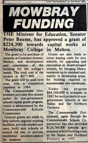
Newspaper, Mowbray Funding, Unknown
" Designed by architect Norman Day, the school was built in an innovative postmodern style. Day’s vision was for the school’s students to feel as comfortable and familiar at school as in their own homes. He based the design on the local suburban typology. The buildings consisted of individual self-contained classrooms, each with a front door, back door and garden. Each class retained the same homeroom for the duration of their schooling. Norman Day won the inaugural Lustig & Moar Architectural Prize in 1988 for his Mowbray College design, and the Australian Library Promotion Council/RAIA Library Design Award for the school’s library building. The school officially opened on 7 February 1983 with an enrolment of 93 students from Prep to Year 7. Mark Fergus was a Prep student in the school’s inaugural year. He later remembered: It was good then because everyone knew each other. Our first few weeks at school we had classes in the Guide Hall because the Mill wasn’t finished. The rest of the school where the Labs and Coppin Court are now was only a big paddock. Another Prep student, Brooke Harrison, recalled: The only recreation we had was the rough playground which consisted of monkey bars, old tractor tyres and a sandpit and high bars. Accidents were a frequent occurrence in those days! It was a friendly atmosphere, you know everyone and their business ... During some classes we used to do horticultural work and planted trees out the front of the school. In 2003, Mowbray College celebrated two decades of educating students in Melton. By that stage, the school had expanded to two campuses with over 1,450 students and 120 staff. It was estimated that over the twenty years since its establishment, 13,000 students passed through the gates. By the mid-2000s, the school offered an International Baccalaureate program and operated across three campuses: the original campus, named Patterson after the first principal, and the Brookside and Town Centre campuses, both located in Caroline Springs. Unfortunately, in 2012 Mowbray College found itself in an unmanageable situation. The community had lost faith in the school’s financial security and as a result some parents withheld their school fees, fearing the school would collapse. It had been in financial difficulty since the mid-2000s and by 2012 was $28 million in debt. 84 In June 2012, all three campuses closed and within four months, each of the campuses of the former Mowbray College had been purchased by other education institutes. Heathdale Christian College bought the original Mowbray campus and established its own campus there and Grace Children’s Services bought the Brookside campus. The Town Centre campus was purchased by Intaj Khan from the Western Institute of Technology but remained vacant after some failed attempts at re-establishing a school. In 2017 the Australian International Academy established an Islamic school on the site".The Express article about a grant for Mowbray Collegeeducation -
 Wodonga & District Historical Society Inc
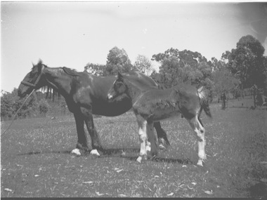
Negative - Haeusler Glass Negatives Collection - Horse and foal
The Wodonga Historical Society Haeusler Collection provides invaluable insight into life in late nineteenth and early twentieth century north east Victoria. The collection comprises manuscripts, personal artefacts used by the Haeusler family on their farm in Wodonga, and a set of glass negatives which offer a unique visual snapshot of the domestic and social lives of the Haeusler family and local Wodonga community. The Haeusler family migrated from Prussia (Germany) to South Australia in the 1840s and 1850s, before purchasing 100 acres of Crown Land made available under the Victorian Lands Act 1862 (also known as ‘Duffy’s Land Act’) in 1866 in what is now Wodonga West. The Haeusler family were one of several German families to migrate from South Australia to Wodonga in the 1860s. This digital image was produced from one of the glass negatives that form part of the collection, probably taken by Louis Haeusler (b.1887) with the photographic equipment in the Wodonga Historical Society Haeusler Collection. This item is unique and has well documented provenance and a known owner. It forms part of a significant and representative historical collection which reflects the local history of Wodonga. It contributes to our understanding of domestic and family life in early twentieth century Wodonga, as well as providing interpretative capacity for themes including local history and social history.Digital image created from the Haeusler Glass negative collection. It depicts a horse and foal standing in a paddock. There is a line of trees in the background.wodonga pioneers, haeusler family, glass negatives, dry plate photography -
 Stawell Historical Society Inc
Photograph, Scar Trees in Lubeck
... . stawell Colour photos of Scar trees, some taken in a paddock. Scar ...Scar Trees – Lubeck. Five photos of Scar trees on the property of Bill Kinsella near Lubeck. The double sided Canoe tree was removed to a park in Horsham on a low loader in 1997. The five photos are spread over 3 photo albums. Album 10 p33 (270) has 1 colour photo of a scar tree, this photo is tree as in Album 24 p30 (bottom right) but a different view. Album 14 p87 has 2 photos (270.1 & 270.1a) the one on the right is the same as the top one in Album 24 p30. This is possible a scar of a boomerang or coolamon as cut to incorporate the root of the tree. Colour photos of Scar trees, some taken in a paddock.stawell -
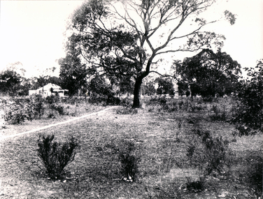 Whitehorse Historical Society Inc.
Photograph - Black and white photo, Games Paddock Blackburn, 1920
Used by donor in 'Blackburn - a picturesque history'Black & white photo of Game's Paddock, cnr. Glen Ebor Avenue & Game Street Blackburn. Shows houses and tree. See page 33 of Da Costa book.|See reference to Miss Game in relation to Sunday School Teachers, Page 64.glen ebor avenue blackburn, game street blackburn, games paddock -
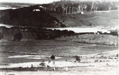 Lakes Entrance Historical Society
Photograph - Butcher's Paddock, 1935c
Copied from postcard in possession of Mrs Vera BennettBlack and white photograph of cleared land on each side of the North Arm, showing white ring barked trees in front of dense bush on western side, cleared and fenced paddocks on eastern side. Lakes Entrance VictoriaPanorama scene at Seaview Tearooms - Lakes Entrancetownship, waterways -
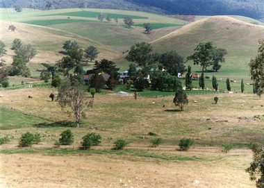 Lakes Entrance Historical Society
Photograph - Buchan Station, Tambo Shire, 1994 c
Also second identical copyColour photograph of Buchan Station, shows farming buildings situated among trees, both cultivated and uncultivated paddocks around property, forested hills in background. Buchan Victoriaagriculture, animals, topography