Showing 295 items
matching park avenue
-
 Power House Rowing Club
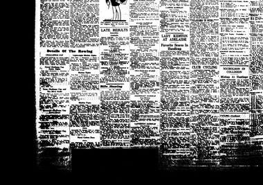
Newspaper clipping, Details Of The Rowing, 1937
CHALLENGE CUP The grand challenge cup (senior eights) brought together what is considered to be the best two club crew in Australia today - New South Wales Police and Albert Park, winners of the Gilbey Cup at the V.R.A. regatta last Saturday. -
 Power House Rowing Club
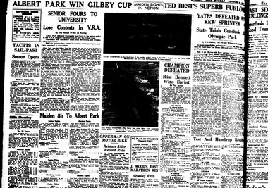
Newspaper clipping, ALBERT PARK WIN GILBEY CUP, 1937
SENIOR FOURS TO UNIVERSITY Lose Contests in V.R.A. Maiden 8's To Albert Park -
 Ballarat Tramway Museum
Photograph - Leaf from a photo album, 1920s
Leaf from a photo album containing 4 black and white photographs pasted onto sheet of brown/grey cardboard with two punch holes at one end. Photos taken early 1920's or just after construction of the Memorial Arch. Photo 1 - "Ballarat" handwritten in pencil at top - Town Hall from the North West taken from a building near Doveton St. Has a Sebastopol tram west bound in Sturt St. passing Town Hall. Photo 2 - "Sturt Street Ballarat" handwritten in pencil at base - Sturt St. Ballarat looking east from most likely the Ballarat City fire station lookout tower. Has a Sebastopol tram travelling eastbound in the photograph. Town Hall in background. No motor vehicles in photograph. Photo 3 - "Memorial Arch, Ballarat" handwritten in pencil at top - photo of the new Memorial Arch at the start of the Avenue of Honour. Photo 4 - "Eureka Stockade, Ballarat" - photo of the Eureka Stockade monument the park.trams, tramways, ballarat, sturt st, memorial arch - avenue of honour, eureka -
 Ballarat Tramway Museum
Album - Photo Album, Ron Scholton, "661", c1989
A photo album, spiral bound with 10 cardboard sheets with photos of late Alf Twentyman cable car set on covers. Each sheet coated with a glue and overlain by a plastic sheet. Album contains 34 photos of BTM W3 661operating in Melbourne 1989 on a charter for Yapper Tours. - no date on photos. Photos taken at Preston depot, South Melbourne loop, Camberwell depot, Thornbury depot, Preston Workshop gates, Sth Melb. depot, Victoria Parade, St Kilda, Brunswick depot, Victoria Market and Kew depot. Also six photos of W1 427 at Kooyong and Dandenong Roads, St Kilda, Batman Avenue, Swan St. bridge, Hawthorn and Wattle Park. See also Reg Item 5986 for a larger more formal album of photographs. Sample of images added 19-12-2016trams, tramways, w3 class, melbourne, w1 class, yapper tours -
 Australian Racing Museum
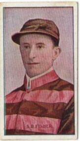
Cigarette Card, Jockey S.D. Fisher, Australian Jockeys, Sniders and Abrahams Issues, Standard Cigarettes, Series of 61 unnumbered, Issued 1908-1909, 1908 - 1909
... (exhibition only) MCG Yarra Park Brunton Avenue Richmond melbourne S.D ...S.D. Fisher, Australian Jockeys, Sniders and Abrahams Issues, Standard Cigarettes, Series of 61 unnumbered, Issued 1908-1909Cream, cardboard card. Front, image of jockey in pink jacket with brown hoops, brown sleeves and brown cap, with jockey name in brown text on bottom of image. Back, 'Standard Cigarettes' in tan text in box.s.d. fisher -
 Australian Racing Museum
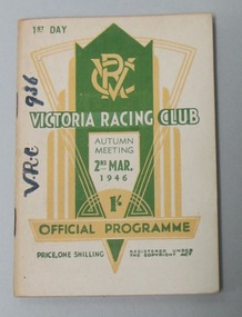
Racebook, Victoria Racing Club, 1946
... (exhibition only) MCG Yarra Park Brunton Avenue Richmond melbourne Un ...Un-numbered page race programme for the Victoria Racing Club Autumn Meeting First Day Saturday 2 March 1946. Front cover has a white background with green and white writing, and a green and yellow 1930s art deco design with the VRC insignia in the middle top. Back cover has a white background with green writing, and a yellow border, explaining the railway arrangements. -
 Australian Racing Museum
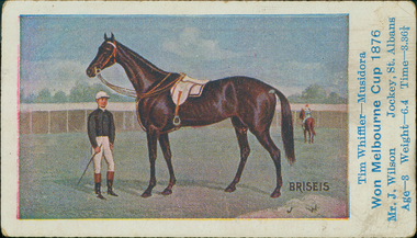
Cigarette Card, race horse Briseis, 1906
... (exhibition only) MCG Yarra Park Brunton Avenue Richmond melbourne ...Cigarette card from the Australian Racehorses series of Melbourne and Sydney Cup winners, issued 1906. . White card, No.15 in the series, with an illustration of a jockey on Briseis, winner of the Melbourne Cup 1876, and details of the horse in blue text. Brown text on verso with details of Sniders & Abrahams. -
 Australian Racing Museum
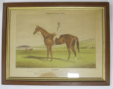
Lithograph
... (exhibition only) MCG Yarra Park Brunton Avenue Richmond melbourne ...race horse Trident with Tom Hales, from the 'Woodhouse's Australasian Winners' series of Frederick Woodhouse Junior -
 Australian Racing Museum
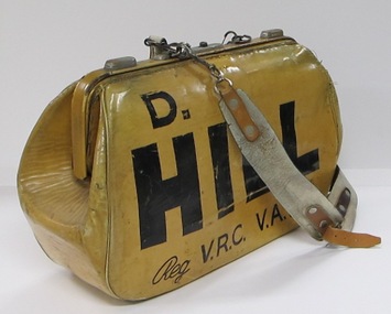
Bookmaker's bag
... (exhibition only) MCG Yarra Park Brunton Avenue Richmond melbourne ...Used by Sidney Hill (Sid's father, also named Sidney Hill, was a bookmaker therefore Sid Jnr used his middle name Desmond).Bookmaker's leather bag, with leather strap and handle, painted 'D. HILL / Reg V.R.C. V.A.T.C.'. -
 Australian Racing Museum
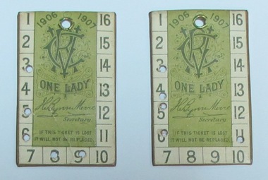
Ticket: Victoria Racing Club Member's Tickets in leather ticket holder, 1906-1907
... (exhibition only) MCG Yarra Park Brunton Avenue Richmond melbourne ...Leather ticket holder containing two Victoria Racing Club lady's tickets for the 1906-1907 season, issued to Mrs L. J. Blyth. -
 Australian Racing Museum
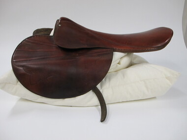
Saddle, race horse
... (exhibition only) MCG Yarra Park Brunton Avenue Richmond melbourne ...Used by George Moore in his last race, the 1971 Victoria Derby, won by classic Mission. Saddle was gifted to Classic Mission's trainer Syd Brown following the race.Leather saddle -
 Australian Racing Museum
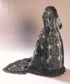
Dress
... (exhibition only) MCG Yarra Park Brunton Avenue Richmond melbourne ...Roselia Isabell Welch was an actress born 16 November 1838, probably in England. Father John Murrell Welch, mother Angela Towsey. Dress has been worn by her descendants.|This decorative day dress was worn by Roselia Welch to the 1872 Melbourne Cup. Roselia made her Cup Day dress by hand - she may have used a published dress pattern but her skill as a needlewoman is evident as the entire surface is decorated with narrow hand beaded black braid applied in a fern-like motif over the blue cotton fabric of the dress creating a lace-like effect.Dress worn by Roselia Isabel Welch to the 1872 Melbourne Cup. White lining inside dress, blue lining inside train. V neck, front hook and eye opening. Handmade hook holes down centre front. Set in sleeves with black piped armhole seams. Fitted bodice with black piped seams Flat front skirt, full bustle area at back with centre back opening. Floor length train. Blue printed label on lining of centre back panel, right side. Upper case letters 'SUP' visible. Brown tape at waist with hook. Two pairs of tapes either side of back opening for bustle. Black lace around neck, sleeve, train and back opening edges. Black cotton loop in centre of train. Inset pockets right side at hip level and very small one left side at waist level. Entire surface of dress decorated with black braid hand stitched in a fern-like pattern. -
 Australian Racing Museum
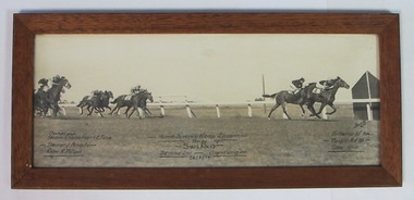
Photo finish; Hume Juvenile Handicap
... (exhibition only) MCG Yarra Park Brunton Avenue Richmond melbourne ...Framed black and white photo finish of the Hume Juvenile Handicap, at Epsom Racecourse on 26 March 1938, won by Swifan. -
 Australian Racing Museum
Helmet, jockey
... (exhibition only) MCG Yarra Park Brunton Avenue Richmond melbourne ...Michelle Payne was the first woman jockey to win the Melbourne Cup on 'Prince of Penzance'Protective helmet worn by Melbourne Cup winning jockey Michelle Payne. -
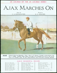 Australian Racing Museum
Sheet music, 'Alax' Marches On
... (exhibition only) MCG Yarra Park Brunton Avenue Richmond melbourne ...Sheet music, first page only, for 'Ajax Marches On', with music by C.A. Schumacher and words by R.E. Holland. The cover has a colour image of Ajax and Maurice McCarten, with details of Ajax's career and race record printed underneath. The verso has the first page of the music with lyrics. -
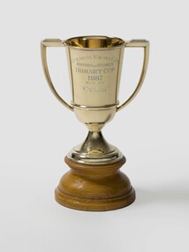 Australian Racing Museum
Tasmanian Racing Club trophy for Benson and Hedges Hobart Cup
... (exhibition only) MCG Yarra Park Brunton Avenue Richmond melbourne Two ...Two handled metal trophy on circular wooden base with blue felt underneath base. Tasmanian Racing Club trophy for Benson and Hedges Hobart Cup won by 'Cylai' in 1987. Small stamps in metal under handle on one side. -
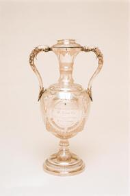 Australian Racing Museum
Corinthian Cup, Caulfield 1878
... (exhibition only) MCG Yarra Park Brunton Avenue Richmond melbourne ...Corinthian Cup, Caulfield 1878. Two handled silver cup with attached flat lid.The Cup was won by Mr J McFarland’s Gratis. Ridden by Mr E French, at Caulfield Racecourse on 1 July 1878. Presented to the Victoria Amateur Turf Club by Mr W Leonard. -
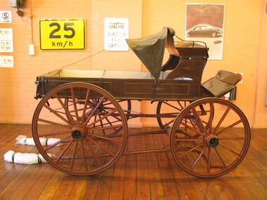 Australian Racing Museum
Ambulance, Jockey
... (exhibition only) MCG Yarra Park Brunton Avenue Richmond melbourne ...Four wheeled single horse-drawn vehicle containing a wooden stretcher, shaded by a black canvas hood. Driver's seat of black leather. Vehicle used as a jockey's ambulance at Caulfield Racecourse during the 1890s.It had space for one stretcher. Horse drawn ambulances, despite having springs, could be very rough to travel in. They were gradually replaced by motor ambulances at Australian race tracks. This ambulance is currently on public display at the Ambulance Victoria Museum in Bayswater. -
 Kew Historical Society Inc
Plan, Melbourne & Metropolitan Board of Works : Borough of Kew : Detail Plan No.1590, 1905
The Melbourne and Metropolitan Board of Works (MMBW) plans were produced from the 1890s to the 1950s. They were crucial to the design and development of Melbourne's sewerage and drainage system. The plans, at a scale of 40 feet to 1 inch (1:480), provide a detailed historical record of Melbourne streetscapes and environmental features. Each plan covers one or two street blocks (roughly six streets), showing details of buildings, including garden layouts and ownership boundaries, and features such as laneways, drains, bridges, parks, municipal boundaries and other prominent landmarks as they existed at the time each plan was produced. (Source: State Library of Victoria)This plan forms part of a large group of MMBW plans and maps that was donated to the Society by the Mr Poulter, City Engineer of the City of Kew in 1989. Within this collection, thirty-five hand-coloured plans, backed with linen, are of statewide significance as they include annotations that provide details of construction materials used in buildings in the first decade of the 20th century as well as additional information about land ownership and usage. The copies in the Public Record Office Victoria and the State Library of Victoria are monochrome versions which do not denote building materials so that the maps in this collection are invaluable and unique tools for researchers and heritage consultants. A number of the plans are not held in the collection of the State Library of Victoria so they have the additional attribute of rarity.Original survey plan, issued by the MMBW to a contractor with responsibility for constructing sewers in the area identified on the plan within the Borough of Kew. The plan was at some stage hand-coloured, possibly by the contractor, but more likely by officers working in the Engineering Department of the Borough and later Town, then City of Kew. The hand-coloured sections of buildings on the plan were used to denote masonry or brick constructions (pink), weatherboard constructions (yellow), and public buildings (grey). Surveyed by the Board of Works in 1903 and published in 1904, Plan No.1590 shows development north of Cotham Road. While this plan includes built structures in Mary Street, Cotham Road, High Street, Park Hill Road, Kent Street, Ridgeway Avenue, and Ermington Lane (now Ermington Place), only part of this section was notated and coloured in this contractor’s copy. Numerous houses, large and small are named on the plan: ‘Cholula’, ‘Belper’, ‘The Uplands’, ‘Spring Grove’ facing Cotham Road; ‘Marion’ facing Kent Street; and ‘Kia Ora’ facing Ridgeway Avenue.melbourne and metropolitan board of works, detail plans, mmbw 1590, survey plans - borough of kew, cartography -
 Kew Historical Society Inc
Plan, Melbourne & Metropolitan Board of Works : Borough of Kew : Detail Plan No.1591, 1905
The Melbourne and Metropolitan Board of Works (MMBW) plans were produced from the 1890s to the 1950s. They were crucial to the design and development of Melbourne's sewerage and drainage system. The plans, at a scale of 40 feet to 1 inch (1:480), provide a detailed historical record of Melbourne streetscapes and environmental features. Each plan covers one or two street blocks (roughly six streets), showing details of buildings, including garden layouts and ownership boundaries, and features such as laneways, drains, bridges, parks, municipal boundaries and other prominent landmarks as they existed at the time each plan was produced. (Source: State Library of Victoria)This plan forms part of a large group of MMBW plans and maps that was donated to the Society by the Mr Poulter, City Engineer of the City of Kew in 1989. Within this collection, thirty-five hand-coloured plans, backed with linen, are of statewide significance as they include annotations that provide details of construction materials used in buildings in the first decade of the 20th century as well as additional information about land ownership and usage. The copies in the Public Record Office Victoria and the State Library of Victoria are monochrome versions which do not denote building materials so that the maps in this collection are invaluable and unique tools for researchers and heritage consultants. A number of the plans are not held in the collection of the State Library of Victoria so they have the additional attribute of rarity.Original survey plan, issued by the MMBW to a contractor with responsibility for constructing sewers in the area identified on the plan within the Borough of Kew. The plan was at some stage hand-coloured, possibly by the contractor, but more likely by officers working in the Engineering Department of the Borough and later Town, then City of Kew. The hand-coloured sections of buildings on the plan were used to denote masonry or brick constructions (pink), weatherboard constructions (yellow), and public buildings (grey). That area of Kew bordered by Cotham Road, Park Hill Road, Ermington Lane (now Ermington Place), and Belmont Avenue contained some of the significant homes owned by Kew pioneers. Chief among these was ‘Park Hill’ on an enormous lot facing Park Hill Road. The Jubilee History of 1910 noted, six years after this plan was drawn, that: ‘Park Hill Road, forming the southern boundary of the cemetery, takes its name from Park Hill, the residence of Mr. Thomas Judd, who has resided there since December, 1852.’ Other named houses on the plan include ‘Ferndale’ facing Cotham Road; ‘Ermington’ adjacent to Judd’s Park Hill, facing Park Hill Road; and ‘Gilden’ and ‘Mont Belmont’ facing Belmont Avenue. Mont Belmont was designed by the architectural firm of Reed, Henderson and Smart for William George Lilley in 1887 and was completed in 1888. Lilley was Mayor of Kew in 1887-88, a Justice of the Peace and a member of the first Board of Guardians of Kew’s St. Hilary’s Church of England.melbourne and metropolitan board of works, detail plans, survey plans - borough of kew, mmbw 1591, cartography -
 Kew Historical Society Inc
Plan - Subdivision Plan, J R Mathers & McMillan, Plan of Subdivision of Part of Crown Portion 83 at Kew : LP6669, 1923-1939
In 1888, in the section of Park Hill Road between Belmont Avenue and Normanby Road there was only one street running between Park Hill Road and Cotham Road. This was Park Road, later to be named Adeney Avenue. Subsequent 20th century subdivisions created the ‘through roads’ of Cecil Street, Wimba Avenue, Florence Avenue, Marshall Avenue, Uvadale Road, and Barrington Avenue. This subdivision represents an attempt by auctioneers, rather than town planners to create an urban environment from larger residential allotments or in many cases farmland. Existing streets such as Parkhill and Normanby Roads provided a convenient starting point for the surveyors, but the Road named ‘Street Street’ indicates the role of the private surveyor in creating streets. Given that a number of allotments are listed as sold on the plan, the street is presumably Cecil Street. Even those lots that had been sold do not quite match the dimensions of the blocks in this parcel of land today, indicating that either further subdivisions or boundary alterations occurred.Subdivision plans are historically important documents used as evidence for the growth of suburbs in Australia. They frequently provide information about when the land was sold as well as evidence relating to surveyors and real estate and financial agents. The numerous subdivision plans in the Kew Historical Society's collection represent working documents, ranging from the initial sketches made in planning a subdivision to printed plans on which auctioneers or agents listed the prices for which individual lots were sold. In a number of cases, the reverse of a subdivision plan in the collection includes a photograph of a house that was also for sale by the agent. These photographs provide significant heritage information relating house design and decoration, fencing and household gardens.The photograph may also be aesthetically significant depending on the importance of the photographic atelier.Hand-drawn subdivision plan of 19 lots facing Parkhill Road, Normanby Road, and an unnamed street [now Cecil Street] in Kew.Estate Agent notes in ink indicate those lots which had sold.subdivision plans - kew, parkhill road - kew, cecil street - kew, normanby road - kew, cecil street -kew, parkhill road - kew, normanby road - kew, crown portion 83 - kew -
 Kew Historical Society Inc
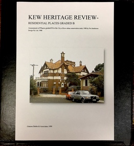
Archive (Sub-series) - Subject File, Kew Heritage Review, Residential Places Graded B, Volume 1, 1999, 1999
... 12 tara avenue 89 studley park road 75 studley park road 44 ...Graeme Butler & AssociatesProject FilesProvenance OrderBlack 4-Ring binder that includes research about, and an assessment of buildings previously graded B in the City of Kew Urban Conservation Study 1988 by Pru Sanderson Design Pty Ltd. The files were created by the heritage architect Graeme Butler and the paper files include maps, correspondence, title searches, readings, reviews of prior classifications, newspaper and journal articles, directories etc for each property assessed.graeme butler, heritage reviews - kew, 20 yarra street, 8 yarra street, 33 wills street, 25 wellington street, 11 wellington street, 118 walpole street, 84 walpole street, 83 walpole street, 63 walpole street, 52 walpole street, 51 walpole street, 14 vista avenue, 12 tara avenue, 89 studley park road, 75 studley park road, 44 studley park road, 25 studley park road, 13 studley avenue, 21 stoke avenue, 71 stevenson street, 34 stevenson street, 12 stevenson street, 36 stawell street, 11 second avenue, 3 second avenue, 2 second avenue, 34 rowland street, 21 redmond street, 11 redmond street, 16 queen street, 27 princess street, 82 molesworth street, 28 miller grove, 26 miller grove, 24 miller grove, 24 milfay avenue, 8 milfay avenue, 4 merrion grove, 25 mary street, 24 lister avenue, 2 john street, 9 hume street, 7 hume street, 24 howard street, 20 howard street, 19 howard street, 10 howard street, 2 howard street, 26 holroyd street, 12 holroyd street, 73 high street, 69 high street, 35 high street, 6 high street, 53 harp road, 6 gellibrand street, 48 foley street, 9 eglinton street, 25-27 edgecombe street, 21-23 edgecombe street, 5-7 edgecombe street, 23 dunlop avenue, 167 derby street, 8 denmark street, 1 denmark street, 2 daracomb avenue, 2 danielle place, 340 cotham road, 294 cotham road, 241 cotham road, 221-229 cotham road, 208 cotham road, 193 cotham road, 180 cotham road, 171 cotham road, 167 cotham road, 161 cotham road, 135-137 cotham road, 46 clyde street, 4 cameron court, 1291 burke road, 1223 burke road, 1205 burke road, 5 bowen street, 35-37 belford road, 389 barkers road, 387 barkers road, 311 barkers road, 231 barkers road, 83-85 barkers road, 15 adeney avenue, 6 a'beckett streetgraeme butler, heritage reviews - kew, 20 yarra street, 8 yarra street, 33 wills street, 25 wellington street, 11 wellington street, 118 walpole street, 84 walpole street, 83 walpole street, 63 walpole street, 52 walpole street, 51 walpole street, 14 vista avenue, 12 tara avenue, 89 studley park road, 75 studley park road, 44 studley park road, 25 studley park road, 13 studley avenue, 21 stoke avenue, 71 stevenson street, 34 stevenson street, 12 stevenson street, 36 stawell street, 11 second avenue, 3 second avenue, 2 second avenue, 34 rowland street, 21 redmond street, 11 redmond street, 16 queen street, 27 princess street, 82 molesworth street, 28 miller grove, 26 miller grove, 24 miller grove, 24 milfay avenue, 8 milfay avenue, 4 merrion grove, 25 mary street, 24 lister avenue, 2 john street, 9 hume street, 7 hume street, 24 howard street, 20 howard street, 19 howard street, 10 howard street, 2 howard street, 26 holroyd street, 12 holroyd street, 73 high street, 69 high street, 35 high street, 6 high street, 53 harp road, 6 gellibrand street, 48 foley street, 9 eglinton street, 25-27 edgecombe street, 21-23 edgecombe street, 5-7 edgecombe street, 23 dunlop avenue, 167 derby street, 8 denmark street, 1 denmark street, 2 daracomb avenue, 2 danielle place, 340 cotham road, 294 cotham road, 241 cotham road, 221-229 cotham road, 208 cotham road, 193 cotham road, 180 cotham road, 171 cotham road, 167 cotham road, 161 cotham road, 135-137 cotham road, 46 clyde street, 4 cameron court, 1291 burke road, 1223 burke road, 1205 burke road, 5 bowen street, 35-37 belford road, 389 barkers road, 387 barkers road, 311 barkers road, 231 barkers road, 83-85 barkers road, 15 adeney avenue, 6 a'beckett street -
 Kew Historical Society Inc
Archive (Sub-series) - Subject File, Kew Heritage Review, Residential Places Graded B, Volume 2, 1999, 1999
... 63 walpole street 14 vista avenue 89 studley park road 12 ...Graeme Butler & AssociatesProject FilesProvenance OrderBlack 4-Ring binder that includes research about, and an assessment of buildings previously graded B in the City of Kew Urban Conservation Study 1988 by Pru Sanderson Design Pty Ltd. The files were created by the heritage architect Graeme Butler and the paper files include maps, correspondence, title searches, readings, reviews of prior classifications, newspaper and journal articles, directories etc for each property assessed. graeme butler, heritage reviews - kew, 25 mary street, 4 merrion grove, 24 milfay avenue, 24 miller grove, 26 miller grove, 28 miller grove, 82 molesworth street, 27 princess street, 16 queen street, 20 yarra street, 84 walpole street, 118 walpole street, 11 wellington street, 83 walpole street, 25 wellington street, 8 yarra street, 33 wills street, 63 walpole street, 14 vista avenue, 89 studley park road, 12 tara avenue, 75 studley park road, 21 redmond street, 52 walpole street, 51 walpole street, 71 stevenson street, 34 rowland street, 21 stoke avenue, 34 stevenson street, 44 studley park road, 25 studley park road, 13 studley avenue, 2 second avenue, 11 second avenue, 3 second avenue, 36 stawell street, 12 stevenson streetgraeme butler, heritage reviews - kew, 25 mary street, 4 merrion grove, 24 milfay avenue, 24 miller grove, 26 miller grove, 28 miller grove, 82 molesworth street, 27 princess street, 16 queen street, 20 yarra street, 84 walpole street, 118 walpole street, 11 wellington street, 83 walpole street, 25 wellington street, 8 yarra street, 33 wills street, 63 walpole street, 14 vista avenue, 89 studley park road, 12 tara avenue, 75 studley park road, 21 redmond street, 52 walpole street, 51 walpole street, 71 stevenson street, 34 rowland street, 21 stoke avenue, 34 stevenson street, 44 studley park road, 25 studley park road, 13 studley avenue, 2 second avenue, 11 second avenue, 3 second avenue, 36 stawell street, 12 stevenson street -
 Kew Historical Society Inc
Archive (Sub-series) - Subject File, Kew Heritage Review, Residential Places Graded B, Volume 3, 1999, 1999
... avenue 16 studley avenue 20 studley avenue raheen, studley park ...Graeme Butler & AssociatesProject FilesProvenance OrderBlack 4-Ring binder that includes research about, and an assessment of buildings previously graded B in the City of Kew Urban Conservation Study 1988 by Pru Sanderson Design Pty Ltd. The files were created by the heritage architect Graeme Butler and the paper files include maps, correspondence, title searches, readings, reviews of prior classifications, newspaper and journal articles, directories etc for each property assessed.graeme butler, heritage reviews - kew, 4 cameron court, 2 hodgson street, 20 fellows street, 26 fellows street, 23 highbury grove, kew lunatic asylum, kew mental hospital, willsmere, 36 stawell street, 13 studley avenue, 16 studley avenue, 20 studley avenue, raheen, studley park road, beament house, 33 uvadale road, 20 yarra streetgraeme butler, heritage reviews - kew, 4 cameron court, 2 hodgson street, 20 fellows street, 26 fellows street, 23 highbury grove, kew lunatic asylum, kew mental hospital, willsmere, 36 stawell street, 13 studley avenue, 16 studley avenue, 20 studley avenue, raheen, studley park road, beament house, 33 uvadale road, 20 yarra street -
 Kew Historical Society Inc
Archive (series) - Subject File, Victoria Park : Concept Management Plan, Research Papers, 2004, 2004
Graeme Butler & AssociatesProject FilesProvenance OrderRed cardboard wallet containing historical research by Graeme Butler, heritage architect, into the history of Victoria Park, Kew. The file also includes a draft Victoria Park Concept Master Plan, 2004. The research includes memoranda, maps, photocopies of plans, forms, notes, aerial photos, and sundry references.graeme butler - heritage architect, victoria park - kew (vic), heritage studies - kew (vic.)graeme butler - heritage architect, victoria park - kew (vic), heritage studies - kew (vic.) -
Kew Historical Society Inc
Archive (Sub-series) - Subject File, JUDD Family, 1958
Various partiesReference, Research, InformationKHS OrderSubject file containing information important information by and about the Judd family, pioneers of Kew, and owners of Park Hill (now in Hillcrest Avenue) from 1853. The file contains a number of original files provenanced to the Judd family including a subdivision brochure of the Park Hill Estate (1916) that includes a map of the subdivision, an early photo of the ten-roomed house. Other primary sources include a seven page photocopy (& transcript) of notes on early Kew by Thomas Judd Jnr (1950). An undated letter accompanying the information refers to Miss Ina Balaam, the last descendant of the family to live in the house. The file also includes a photocopy of the obituary of Thomas Judd and a newspaper article/clipping from 1972, which includes a short history of the house and a photograph. Other items relating to Thomas Judd and James Bonwick are stored in archive boxes in the collection store.c w rick fairhall, parkhill - hillcrest avenue - kew (vic), thomas judd, pioneers - kew (vic)c w rick fairhall, parkhill - hillcrest avenue - kew (vic), thomas judd, pioneers - kew (vic) -
Kew Historical Society Inc
Archive (Sub-series) - Subject File, Kew Historical Society, Gardens (Kew), 1979
Various partiesReference, Research, InformationSecondary Values (KHS Imposed Order)Correspondence and newspaper articles/clippings relating to historic gardens in Kew. The oldest item is a letter from the National Trust Victoria announcing their two-year garden study and seeking information on gardens in Kew. Mavis Rolley, Secretary of the Society, made handwritten notes in response, which are kept in the file. She refers to: the pear trees planted by William Oswin in c. 1845 near what is now the Burke Road Bridge (she notes that a search for the trees at the time of the construction of the Eastern Freeway was unsuccessful), a camellia planted by the Dannocks near the corner of Derby and High Street, a c.1876 pine tree in Field Place, Henty Court, an 1875 Moreton Bay fig at Tarring, Ruyton, a Moreton Bay fig at Roxeth, Trinity Grammar, an 1840s oak tree and a 120-year old olive tree at Fairholme, Barry Street, 1870 pine trees at D’Estaville, Barry Street, trees at Turinville, Barnard Grove, dating to 1846, pine trees dating from 1845-6 on the Willsmere Farm, red gums in Victoria Park, pine trees in the Cemetery dating from the 1860s, trees in the Alexandra Gardens and at Kew Primary School, palm trees at La Verna, Sackville Street dating from the 1890s, the trees and gardens at Ross House (Charleville), and the trees at Merridale, Sackville Street which date from the 1880s, a magnolia at Lalla Rookh. These dates are probably highly contestable. Other handwritten notes from 1979 about significant gardens included: 5 Molesworth Street, Red Bluff - Redmond Street (garden now destroyed), Campion House, Studley Park Road, Raheen, Studley Park Road, Ross House, Cotham Road (Charleville), 7 Adeney Avenue, 20-21 Belmont Avenue, 52 Mary Street, an Edna Walling garden on the corner of Argyle Road and Victor Avenue, Merridale, Sackville Street, Roseneath, and Reno, St John’s Parade.gardens - private - kew (vic), garden design - kew (vic), kew horticultural societygardens - private - kew (vic), garden design - kew (vic), kew horticultural society -
 Kew Historical Society Inc
Album - Scrapbook, Eva Grant, Historic Buildings, Kew, 1958-78, 1970s
One of three scrapbooks of photographs and newspaper cuttings taken and or collected by Eva Grant, a past member of the Kew Historical Society, which were donated by her niece, Julie Thomson. The albums include many photographs of Kew from the 1950s to the 1970s. Buildings included in the scrapbook include: Billy Hughes' house - 167 Cotham Road Congregational Church - Walpole Street (c.1978) Country Roads Board - Denmark Street (1960) Dorothy Rogers Reserve - Studley Park Road Ellsmere (also Ellesmere/Ellsmore) - Princess Street Field Place - 3 Henty Court Fernhurst - 13 Fernhurst Grove Kew Civic Centre (1959) Kew Junction (1958) Kew Railway Station (1902, 1959) Kew Recreation Hall - Wellington Street (1960) Neama (Hall) - Studley Park Road Southesk (formerly Ordsall) - Cotham Road (c.1960) St Anthony's Home for Babies (formerly Madford) - 43 Wellington Street (c.1976) Studley House - Nolan AvenueThe scrapbook contains historically significant, rare and sometimes unique images of significant heritage buildings in Kew, including their erection and demolition. 11-page scrapbook of photographs and newspaper clippings with annotations by Eva Grant, a past member of the Kew Historical Society. The pages of the album can be viewed in the image carousel above. Based on the text and known dates of demolition of a number of the buildings, the scrapbook was assembled over a twenty year period between c.1958-c.1978.Includes letter from donoreva grant, billy hughes' house - 167 cotham road, congregational church - walpole street - kew, country roads board - denmark street - kew, dorothy rogers reserve - studley park road - kew, field place - 3 henty court - kew (vic), ellsmere (also ellesmere/ellsmore) - princess street - kew, fernhurst - 13 fernhurst grove - kew (vic), kew civic centre - civic drive - kew (vic), kew junction - kew (vic), kew railway station - denmark street - kew (vic), recreation hall - wellington street - kew, neama - hall - studley park road - kew (vic), southesk - ordsall - cotham road- kew (vic), st anthony's home for babies - madford - 43 wellington street (vic), studley house - nolan avenue - kew (vic) -
 Kew Historical Society Inc
Photograph, J F C Farquhar, Studley Park Road, 1891
At the beginning of the 1890s, the Kew businessman and Town Councillor, Henry Kellett, commissioned J.F.C. Farquhar to photograph scenes of Kew. These scenes included panoramas as well as pastoral scenes. The resulting set of twelve photographs was assembled in an album, Kew Where We Live, from which customers could select images for purchase.The preamble to the album describes that the photographs used the ‘argentic bromide’ process, now more commonly known as the gelatine silver process. This form of dry plate photography allowed for the negatives to be kept for weeks before processing, hence its value in landscape photography. The resulting images were considered to be finely grained and everlasting. Evidence of the success of Henry Kellett’s venture can be seen today, in that some of the photographs are held in national collections.It is believed that the Kew Historical Society’s copy of the Kellett album is unique and that the photographs in the book were the first copies taken from the original plates. It is the first and most important series of images produced about Kew. The individual images have proved essential in identifying buildings and places of heritage value in the district.In this view of Studley Park Road, looking northeast to the Junction, the photographer invites the viewer to participate in a point-of-view that emphasises the elevated, tranquil vantage point of the hill in contrast to the bustling commercial area in the distance. The view emphasises the exclusiveness of Studley Park, with its high fences behind which a number of significant Kew mansions were concealed. Contemporary advertisements for the sale of mansions in Studley Park Road often included fulsome descriptions of their elaborate formal gardens, as well as paddocks for grazing, stabling and dairies. None can be seen here. The use of high, protective wooden pickets to surround the newly planted avenue of elms on the south side of the road appears to be typical of the period. Similar examples can be seen in early photographs of Wellington and Princess Streets.The horse and carriage, selected as a central focus of the view, reinforces the residential, exclusive nature of this part of Kew in the early 1890s. Studley Park Roadkew illustrated, kew where we live, photographic books, henry kellett -
 Kew Historical Society Inc
Photograph, J F C Farquhar, The Yarra in Hyde Park, 1891
... by Willsmere and Kilby Roads and White Avenue. In 1982, Hyde Park... The Yarra in Hyde Park Hyde Park is now a small recreation reserve ...At the beginning of the 1890s, the Kew businessman and Town Councillor, Henry Kellett, commissioned J.F.C. Farquhar to photograph scenes of Kew. These scenes included panoramas as well as pastoral scenes. The resulting set of twelve photographs was assembled in an album, Kew Where We Live, from which customers could select images for purchase.The preamble to the album describes that the photographs used the ‘argentic bromide’ process, now more commonly known as the gelatine silver process. This form of dry plate photography allowed for the negatives to be kept for weeks before processing, hence its value in landscape photography. The resulting images were considered to be finely grained and everlasting. Evidence of the success of Henry Kellett’s venture can be seen today, in that some of the photographs are held in national collections.It is believed that the Kew Historical Society’s copy of the Kellett album is unique and that the photographs in the book were the first copies taken from the original plates. It is the first and most important series of images produced about Kew. The individual images have proved essential in identifying buildings and places of heritage value in the district.Hyde Park is now a small recreation reserve bordered by Willsmere and Kilby Roads and White Avenue. In 1982, Hyde Park was cut off from the Yarra River by the construction of the Eastern Freeway. The building of the latter was to transform the natural landscape, including the Yarra, as well as Hyde Park. The construction of the Freeway makes it difficult to view the scene with the photographer’s eye. Today’s Hyde Park is located on land purchased in 1847 by John Cowell, and in 1851 Catherine Cowell, yet the scene selected by the photographer may well have been located on farmland owned by the Wills family. Farquhar’s point-of-view emphasises both the pastoral and recreational elements of the scene: the grazing cows, three boys, and in the distance two figures, seated on the bank with a parasol. By 1891, an environmental consequence of human activity, including farming, was deforestation, leading to the erosion of the south bank of the Yarra. In contrast, the land on the Alphington side of the river in 1891 included remnant bushland.The Yarra in Hyde Parkkew illustrated, kew where we live, photographic books, henry kellett, yarra river