Showing 286 items
matching planting group*
-
 University of Melbourne, Burnley Campus Archives
Photograph - Black and white prints and negatives, Department of Agriculture, Victoria, Flowers and Plants, 1961-1962
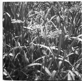
21 envelopes marked Department of Agriculture (Vic), 1 empty. Photographs and most negatives. All labelled, mainly flowers and plants. (1) Neg. only, 'Lupinus'.' (2) 'Iris fulva B/G 23/10/61.' (3) 'Iris pseudacorus.' (4) 'Muscari plumosum B/G 23/10/61.' (5) 2 copies 'Erythrinum.' (6) 'Iris sibirica B.G. 23/10/61.' (7) 3 Neg. and 4 photographs 'Green, Variegated Agave.' 'Ref to Mr. Littlejohn.' (8) 'Pebble Mulch,' 'Rock Mulching Rock from Apollo Bay Mentone 23/10/61 ₤22.' (9) 'Gazania B.G. 23/10/61.' (10) Neg. only 'Grevillea hookeriana.' (11) Photograph only 'Hibiscus.' (12) 'Euphorbia Crown of Thorns BG 23/10/61.' 'Euphorbia splendens.' (13) 2 copies 'Greyia sutherlandii 23/10/61.' (14) 3 copies 'Aeonium Grouped with other succulents including Bryophyllum, Dickia, Echevera' 'Jan Jul '62 Photo E.G. Littlejohn.' (15) 'Agave Agave-variegated in tub.' (16) 'Lathyrus odoratus' '(Sweet Pea) on support B.G. 23/10/61.' (17) 'Pelargonium' B/G 23.10.61.' (18) 'Pelargonium.' (19) 'Callistemon coccineus.' 'Return to Mr. Littlejohn Burnley Gardens.' (20) 3 copies 'Aloe.' 'Return to Mr. Littlejohn Aloe.'flowers, plants, lupins, iris, agave, pebble mulch, rock mulch, grevillea, hibiscu, euphorbia, succulents, bryophyllum, dickia, echevera, e.g. littlejohn, pelargonium, burnley gardens, aloe -
 Vision Australia
Photograph - Image, Charles Nettleton, Blind Asylum School, St Kilda Road, circa 1875
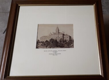
... in 1875. The four storey bluestone building rises above a group... storey bluestone building rises above a group of trees planted ...Unsubstantiated photograph of the Asylum for the Blind in 1875. The four storey bluestone building rises above a group of trees planted in the garden. A picket and wire/string fence border the unpaved circular driveway. 2 black and white images of the Guiding Light at Elanora Blind Asylum School, St Kilda Road Victoria c. 1875 Charles Nettleton 1826-1902 Spencer Scott Sandilands 546 High Street, East Preson, 3181 Melbourne, Victoria, Australia, Tel: (03) 529 8011 Fax: (03) 521 1754 33 George Street, The Rocks, 2000 Sydney, New South Wales, Australia, Tel: (02) 241 4251 Fax: (02) 2414535 Rare Prints, Antiquarian Books, Old Maps, Australiana, Antiques, Photographs, Framing c.1875 Charles Nettleton School from the Blind Original Photograph $65 Guaranteed over 100 years oldroyal victorian institute for the blind, buildings -
 University of Melbourne, Burnley Campus Archives
Album - Digitised, Joanne Morris, Visit to Burnley April 2014, 2014
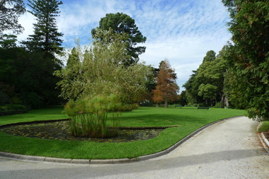
Collection of digitised photographs taken in preparation for the Class of 1973 Reunion in 2014. Garden views and buildings. Donated by Joanne Morris, former student, in June 2014. See Digitised photos- Garden Views folder- Visit to Burnley April 2014. (1) Luffmann Ponds. (2) Administration Building. (3) Emily Gibson Beds and Ginkgo biloba. (4) Looking towards Native Garden. (5) Oak tree. (6) Looking towards Rose Garden. (7) Looking towards Stream Garden and Fern Garden. (8) Looking towards Rose Garden. (9) Plaque at entrance to Field Station. (10) New gates at entrance to Field Station donated by the Friends of Burnley Gardens. (11, 12) Field Station. (13) Plaque in Herb Garden commemorating Enid Carberry. (14) Fountain in Herb Garden commemorating Enid Carberry. (15) Forestry Building. (16-18) Inside Forestry Building. (19) Sugar Gum Table Setting donated by the Friends of Burnley Gardens. (20) Plaque on Sugar Gum Table commemorating Geoff Olive. (21, 22) View of Luffmann Ponds and Summer House. (23) Plaque at Luffmann Ponds. (24) Luffmann Ponds. (25) View of former Egg-Curator's Residence from Nursery. (26) Back of Nursery. (27,28) The Burnley entry for the Melbourne International Flower and Garden Show 2014. (29) Back of Administration Building. (30) Plant Science Laboratories. (31) Student Amenities Building. (32-34) Plant Science Laboratories. (35) Citriodora Court. (36) Eucalyptus maculata at entrance to Native Garden. (37) Native Garden, James Hitchmough Grasslands. (38) Garden view. (39) Inside the Hall. (40,41) Roof Garden. (42,43) Library. (44-50) Views of the Quad and classrooms. (51) Dairy. (52) Building 904,(Centre for Urban Horticulture) now Waterway Ecosystem Research Group. (53) Yarra Boulevard entrance.class 1973, class reunion, garden views, buildings, joanne morris, students, luffmann ponds, administration building, emily gibson beds, ginkgo biloba, native garden, oak tree, rose garden, stream garden, fern garden, field station, friends of burnley gardens, plaques, herb garden, enid carberry, fountain, forestry building, sugar gum table, geoff olive, summer house, egg-curator, residence, nursery, melbourne international flower and garden show, 2014, plant science laboratories, student amenities building, citriodora court, eucalyptus, james hitchmough grasslands, roof garden, library, quad, classrooms, dairy, centre for urban horticulture, waterway ecosystem research group, yarra boulevard entrance -
 University of Melbourne, Burnley Campus Archives
Photograph - Colour print, Student Outside Class
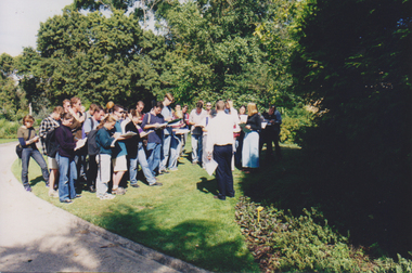
5 photographs of a group of students being instructed by ?. Probably Plant ID.students, class, plants, identification -
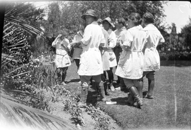
 University of Melbourne, Burnley Campus Archives
Photograph - Colour print, Student Outside Class
... A group of students instructed by ?. Probably Plant ID. Student ...A group of students instructed by ?. Probably Plant ID.students, class, plants, identification -
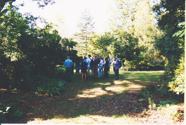 University of Melbourne, Burnley Campus Archives
Photograph - Colour print, Student Outside Class
... A group of students on the lawn looking at plants. Student Outside ...A group of students on the lawn looking at plants.students, class, plants, identification -
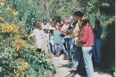
 University of Melbourne, Burnley Campus Archives
Negative - Black and white negative, Student Outside Class, 1922-1923
Black and white photograph. Group of students standing beside a flower bed holding exercise books (plant identification?).students, flower beds, j.l. provan, student outside class -
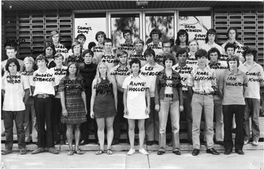 University of Melbourne, Burnley Campus Archives
Photograph - Black and white print, Information Branch Victorian Department of Agriculture, 1972 Intake, 1972
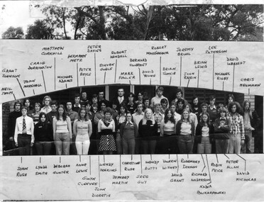
... group diploma I plant science laboratory Names handwritten ...3 copies black and white photograph. Group of students standing in front of the Plant Science Laboratory.Names handwritten on front. On reverse of one copy, "Dip I '72, Dip III 74 add Shoebridge," also, "Photograph by Information Branch Victorian Department Of Agriculture Ref. No. D.1912.B."student group diploma l 1972, student group, diploma i, plant science laboratory -
 University of Melbourne, Burnley Campus Archives
Photograph - Black and white print, 1976 and 1977 Diploma Students, 1976
... Boulevard Richmond melbourne plant science laboratory. student group ...Black and white photograph. Group of 1976 and 1977 Diploma students standing on the steps of the Plant Science Laboratory. Handwritten names pasted on photograph. plant science laboratory., student group diploma 1976, student group diploma 1977, diploma, student group -
 University of Melbourne, Burnley Campus Archives
Photograph - Black and white and colour slides, colour negative, Miscellaneous Horticulture, 1947-1985
57 slides and 1 negative. (1) "1947 Rolling the surface," in front of the newly constructed Administration Building. (2) "5-5-60 Same tree 7 months later-New Growth." (3) Men standing around a large horticultural machine. (4) "Lawns Housing Com" Aug "66?" (5) "Flemington Racecourse." (6) "Mustard-Cover Crop. 1960." (7) Tree climbing. (8) "Grafting-scions. BHC." (11) "Mildura-Soil Probe Oct 67." (12) Virus tested stock trees & layout Flemings Apr 70." (13) "Best's Winery Mar 75." (15, 16) Best's single student and group. (17) "Ploughing-Diagram to show incomplete cover of trash? Farm Practices." (18) "Spraying Hand Equipment for Insect Control in and around Buildings USA Yearbook 1952." (19) "Pasture Harrows." (20) "Mould Board Plough-Tractor." (21) "Disc Harrows-Offset-Tractor." (22) Tyne Cultivator-for Tractor." (23) See B91.258." (24) Burnley College libary. (25) "Irrigation-Delver Tatura 12/59." (26) "Tatura 12/59 Delver Ferguson T." (27) "Wilson's Prom? date." (28) "Wilson's Promontary Nov 1960 lunch." (29) "W. Prom." (30) Camp 1957 Wilson's Promontary." (31)" Longeronong Field Day 1964 Machinery Combination (Small)." (32, 33) "Longeronong Field Day 1964 Machinery Cultivating." (34-36) Photographs of plants in book. (35) Alnus? (37) "Meterosideros excelsa." (38) "Rhipsalidopsis rosea." (39) "Protea neriifolia." (40) Banksias-Species." Insects: (41) "Lacewing larva." (42) "Mites Aug 75." (43) "Yellow Mite, Red Spider (Arachnida)." (44) "Jassid-Life Cycle 9/51." (45) "Grape Fruit Crop (Florida) Destroyed by Fruit Fly. Animals without backbones." (46) "Jassid-Vegetable 9/51." (47) "Field Day 57 (Fruit Fly-Enlarged)." (48) "Field Day 57 (Fruit Fly-Stages)." (49) Insect Life Cycle. (50) "Comatibility (sic) Chart." for Insecticides & Fungicides. (51) "Insecticides-Toxicity." (52) "Life Cycle of the Leather Jacket." (53) "Grasshopper-Head Dissected Mouth Parts." (54) "Types of Antennae." (55) "Spider Mites USA Yearbook 1952." (56) "Cultivator." (57) "Organic Phosphates." (58) Negative Isopogon anemonifolius.administration building, lawns, flemington racecourse, mustard-cover crop, tree climbing, grafting, mildura, soil probe, pests, machinery, excursions, tatura, library, wilsons promontory, plants, alnus, zygocactus, schlumbergia, feijoa, acca sellowiana, protea neriifolia, banksia, isopogon anemonifolius -
 University of Melbourne, Burnley Campus Archives
Photograph - Black and white and colour prints, Information Branch Victorian Department of Agriculture, Staff, 1981-1984
Staff: (3) Lucy Connop (4) Wendy Jones (8) John Billing (15) Margaret Fogarty (16 Megan Donald (17) John Philp (18) Jenny Leereveld (19) Sue Berkeley (20) Mark Hagell (28) Philip Moyle (29) Danny Cotter (30) Gabrielle Vivian-Smith (31) Sally Williams (32) Stuart Portbury (33) Phil Tulk (34) Jeremy Wallace (35) Veneta Grivas (36) Patrick Howden (37) Marion Hill (38) Jayne Lindholm (39) Marian Verhooght (40) Cathy Morley (42) Russell Benallack (43) Paul Rebeschini (44) Jim Pleasance (45) Jim Wood (46) Peter Rumble (47) Jolyon Burnett (48) Lynn M. Burnett (49) Paul A. Elliot (50) Ivo Dean (51) Maria Malzone (52) Hans Frederic (53) Anthony W. Meagher (54 John W. Patrick (56) John L. Patience (61) Geoff Olive (62) Robert M. Hardie (63) Daryl Jowett (64) Dirk van Velzen ((66) Pamela Tumath (69) Darryl Cubbs (70) Jim Pleasance (81) Fred Helregal 01.0801984 (82) Staff group (83) V.C.A.H. Burnley Open day Staff at a stand (84) Graduation group (85) Graduation speaker (86) Graduation-tree planting (89-92) VCAH stamp 2/84 (95) VCAH stamp 2/84 (96) Peter Oppenheimer and student 1981 Dept of Agriculture stamp.staff, lucy connop, wendy jones, john billing, margaret fogarty, megan donald, john philp, jenny leereveld, sue berkeley, mark hagell, philip moyle, danny cotter, gabrielle vivian-smith, sally williams, stuart portbury, phil tulk, jeremy wallace, veneta grivas, patrick howden, marion hill, jayne lindholm, marian verhooght, cathy morley, russell benallack, paul rebeschini, jim pleasance, jim wood, peter rumble, jolyon burnett, lynn m. burnett, paul a. elliot, ivo dean, maria malzone, hans frederic, anthony w. meagher, john w. patrick, john l. patience, geoff olive, robert m. hardie, daryl jowett, dirk van velzen, pamela tumath, darryl cubbs, fred helregal, open day, graduation, tree planting, vcah, peter oppenheimer -
 University of Melbourne, Burnley Campus Archives
Album - Black and white and colour slides, Burnley Views, 1947-1955
Contributor: T.H. KneenCardboard box of 108 35mm glass slides in metal frames made by "Gnome." Box labelled "Burnley Gardens Slides." Also 16 unused slides (1) Swan Street entrance c. (2) Orchid? b/w. (3) Nursery b/w. (4) Pasture area with man working b/w. (5) Draught horse working in the Orchard b/w. (6) Crop of corn in the Orchard c. (7) Magnolia c. (Magnolia x soulangeana). (8) Display of orange flowers c. (9) Lemon tree in the Orchard c. (10) Sign advertising 'Fruit Tree Pruning Demonstarion Sat. 2nd July (1949) c. (11) Jersey cow c. (12) Rock Point c. (13) Dahlias in the Orchard c. (14) Foundation Stone '28th August, 1946' c. (15) Felled Cypress tree 1951 b/w. (16) School truck in front of glasshouses and cacti b/w. (17)Administration Building completed but surrounded by rubble C.1949 c. (18) Plant Research Institute c. (19) Inside a glasshouse. c. (20) Administration Building c. (21) Group of female students dressed up for a function c. (22) Solenostemon (Syn. Coleus) in a glasshouse. (23, 24)Stock Matthiola incana. (25) Blossom in the Orchard c. (26) Orchard c. (27) Picking fruit in the Orchard c. (28) 2 female students holdong large bunches of poppies c. (29) Flowers growing in the Orchard c. (30) House - not Burnley c. (31) Students on an excursion c. (32) Staff member with Gladioli c. (33) Garden view - not Burnley? c. (34) Administration Building c. (35) Roses c. (36) Flowers in the Orchard c. (37) Draught horse working in the Orchard c. (38) Staff member amongst flowers in the Orchard c. (39) Garden view c. ((40) Blossom in the Orchard c. (41) Orchard c. (42) Flowers inside glasshouse c. (43) Mesembryanthemums in pots possibly in the nursery c. (44) Tree b/w. (45) Garden bed c. (46) Sign, 'Agrostology Branch, pasture Plant Research Field,' c. (47) Path to Principal's Residence c. (48) Irrigation in the Orchard b/w. (49) Cactus flowers b/w. (50) Garden view with T.H. Kneen children playing c. (51) (52) Cinerarias (now Pericallis x hybrida) in pots c. (53) Temporary building where the Grey Garden is now b/w. (54) Garden view b/w. (55) Unknown building b/w. (56) Person pruning in the Orchard c. (57) Students working in the Orchard c. (58) Swan Street with recently completed rock wall constructed by the Public Works Department b/w. (59) Lagoon paddock b/w. (60,62) Pavilion and new Administration Building before the Pavilion was removed b/w. (61) As (60) but viewed from a different direction c. (63) Plant c. (64) View through a window on the stairs in the Administration Building c. (65) Plant c. (66) Garden view of trees c. (67) Garden View b/w. (68) Blossom tree c. (69 )Garden view along path to Principal's Residence c. (70) Lagoon Paddock c. (71) Lagoon Paddock with cows b/w. (72) Inside a glasshouse b/w. (73) Entrance sign- Department of Agriculture Burnley Gardens, School of Horticulture & Primary Agriculture, Plant Research laboratory, Agrostology Branch, Fruit Preserving Branch c. (74) Plant Research Laboratory b/w. (75) Students on an excursion c. (76) Glasshouses b/w. (77) Garden view b/w. (78) Kniphophia c. (79) Hibiscus c. (80) Garden view c. (81) Dairy, Silo and dog b/w. (82) Irrigation in then Orchard b/w. (83) Garden view with magnolia c. (84) Flower plots in the Orchard c. (85) Pruning demonstration b/w. (86) Administration Building under construction c. (87) Rock Point c. (88) Mrs Kneen and Magnolia c. (89) Glasshouses c. (90) Sequoia sempervirens b/w. (91) Inside Administration Building c. (92) Luffmann Ponds b/w. (93) Sequoia sempervirend, Mrs Kneen and child c. (94) Garden bed in front of Sequoian sempervirens c. (95) Principals Residence b/w. (96) Poultry pens b/w. 1947 (97) Principals Residence b/w. (98) Student picking fruit from netted tree b/w. (99) Rock Point and Long Border c. (100) Administration Building under construction c. (101) Greenhouse b/w. (102) Rock Point c. (103) Flowers in the Orchard c. (104) Waterlilies in the Pond c. (105) Blossom tree c. (106) Hilda Kirkhope Rockery c. (107) Long Border c. (108) Plant Research Institute with flower border along drive c.burnley gardens, flower, nursery, pasture, draught horse, orchard, crops, magnolia, chicken coops, egg laying competition -
 Friends of Ballarat Botanical Gardens History Group
Work on paper - North Gardens Wetlands Information Notes, Friends of Ballarat Botanical Gardens (Guiding Friends Group), C 2001
Important information about the North Gardens Wetlands and the primary objective of improving storm water quality.This project was completed in March 2001 and besides its ecological importance, it provides a destination at the northern end of the Gardens, creates social linkages between various environmental groups as well as improving the aesthetic standards of the site.1 page set out with subheadings.Nonenorth gardens, north gardens wetlands, north gardens wetlands project, ballarat botanical gardens, friends of ballarat botanical gardens, john garner, regional indigenous plants, aquatic and terrestrial plants, storm water, john garner collection, gardens, ballarat, garner -
Friends of Ballarat Botanical Gardens History Group
Work on paper - Simon Grant: Part 5 of the Explorers, David Douglas in the Land of Giants, Published 1998
David Douglas (1799-1834) journeyed to the Pacific North-West as well as to other parts of the New World looking for new species of plants. The Royal Horticultural Society of London hoped to introduce new and exciting plants to its gardens.After Douglas's explorations in the New World, hundreds of new species became available. As a result flower beds and theme gardens with new exotic specimens and aboreta became fashionable. This information gives some perspective on the planning and development of the Ballarat Botanical Gardens.2 pages of print in columns. There is a black and white photograph of David Douglas halfway down the page on the lefthand side of p.1. On p.2 there is a black and white photograph of the Douglas Fir on the lefthand side of the page and lower down a photograph of Lupinus polyphyllus.none.john garner, doctor john garner, ballarat botanic gardens, friends of ballarat botanical gardens, david douglas, royal horticultural society, kew gardens, douglas fir, sitka spruce, radiata pine, john claudius loudon, joseph banks, john garner collection, gardens, ballarat -
Friends of Ballarat Botanical Gardens History Group
Work on paper - Simon Grant: Part 7 of The Plant Hunters, Sir Joseph Dalton Hooker: 1817-1911, C 1998
Sir Joseph Dalton Hooker was the leading botanist of the 19th century and director of one of the world's great botanic gardens, Kew. He was a friend of Charles Darwin and became famous through his numerous publications after extensive explorations.Joseph Hooker's last publication covered all the known members of 200 plant families and was the basis for the ordered arrangement of species for 130 years until it was replaced by a DNA-based one.2 pages and a small paragraph on p.3. On p.1, there is a black and white photograph of Joseph Hooker halfway down the left column of the page. On the second page, there is a coloured photograph of Magnolia campbellii halfway down the left column and another coloured photograph of Rhodendron thomsonii almost halfway down the right column. p.3 has 2 coloured photographs and news of the Southern Highlands Botanic Gardens.None.john garner, doctor john garner, ballarat botanical gardens, friends of ballarat botanical gardens, sir joseph dalton hooker, botanist, charles darwin, plant hunter, kew gardens, john garner collection, gardens, ballarat -
Friends of Ballarat Botanical Gardens History Group
Work on paper - Plant Transportation, A Brief History, July, 2007
Plant transportation was important especially in establishing new gardens and in reminding those living in strange lands, of home.The transportation of plants from other parts of the world was important in establishing the Ballarat Botanical Gardens and other gardens in Australia.4 pages with subheadings on pp. 1-4.Nonejohn garner, doctor john garner, plant transportation, ballarat botanical gardens, friends of ballarat botanical gardens, the australian experience of plant transportation, ballarat experience of plant transportaion, john garner collection, gardens, ballarat -
Friends of Ballarat Botanical Gardens History Group
Work on paper - Carolus Clusius, 16th century scientific horticulturist, Wikipedia, 22/06/2009, 22/06/2009
Clusius's early work relates to some of the plants in the Ballarat Botanical Gardens today, for example, tulips. Carolus Clusius was a pioneering botanist and one of the most influential 16th century scientific horticulturists.2 pages with a photograph labelled Charles de l'Ecluse on the left of p.1 and a drawing of a Nymphaea on the lefthand side of the page. p.2 has a list of the works of Charles de l'Ecluse, bottom half of the page. Nonedoctor john garner, john garner, ballarat botanical gardens, friends of ballarat botanical gardens, 16th century, carolus clusius, charles de lecluse, l'escluse, pioneering botanist, scientific hoticulturist, tulips, alpine plants, genus clusia, european flora, john garner collection, gardens, ballarat -
Friends of Ballarat Botanical Gardens History Group
Work on paper - A Brief History of Plant Hunters, Plant Collections and Gardens, 2013
This article gives a useful introduction to European plant hunters and their work in compiling plant lists and establishing gardens with many new species.Unusual new species discovered by plant hunters and introduced to European gardens, eventually, in the nineteenth century, became important in the establishment of the Ballarat Botanic Gardens. Many new plants were imported especially from Britain. 2 pages, (pp.3-4.) The print is arranged in columns. In the top lefthand corner is a colored representation of Queen Hatshepsut and opposite, in the righthand column is a picture of Carolus Clusius. On p.2 (p.4), top lefthand corner is a framed portrait of John Tradescant the Elder reproduced in colour. and another portrait in colour of John Tradescant, the younger in the lefthand bottom corner. There are references and further reading middle of the right hand column.None.john garner, doctor john garner, ballarat botanical gardens, friends of the ballarat botanical gardens, john tradescant, carolus clusius, botanic gardens, plant hunters, plant collections., gardens, ballarat, john garner collection -
Friends of Ballarat Botanical Gardens History Group
Work on paper - Robert Fortune (1812-1880), Carolyn Blackman, "Empire of Flowers" in Australian Garden history, Vol.12 No.5 March/April 2001, C. March/April 2001
Robert Fortune introduced 190 species of Chinese plants to Britain and the West.This article gives a brief background to some of the plants originally from China, that can be seen in the Ballarat Botanical Gardens.2 pages of print in columns. The first page has three pictures of plants on the lefthand side with a floral background. The second page has a floral backround on the righthand side.Nonejohn garner, doctor john garner, ballarat botanical gardens, friends of ballarat botanical gardens, robert fortune, china, wisteria sinensis, azaleas, reeves collection, john reeves., john garner collection, gardens, ballarat -
Friends of Ballarat Botanical Gardens History Group
Work on paper - Methods of Transporting Plants:, From Bottles to Wardian Cases, Unknown
Until the Wardian Case was invented, other methods of transporting plants had been rarely successful.The Wardian case was used to transport plants to be grown in the Botanical Gardens and other gardens in Ballarat.1 page with 2 sections. Top of the page is blurred and cutoff. Left bottom of page, 2 sketches of methods of transporting plants and right side, bottom half of the page, a sketch of the wardian case.Nonejohn garner, doctor john garner, ballarat botanical gardens, friends of ballarat botanical gardens, the wardian case, joseph paxton, doctor nathaniel ward, nineteenth century, john garner collection, gardens, ballarat -
Friends of Ballarat Botanical Gardens History Group
Work on paper - Differing Styles of Wardian Cases, The Transportation of Plants to Ballarat and Other Parts of the World, 27/2/2009
Wardian cases made it possible for plants and seeds to be transported long distances and to be in good condition on arrival.Without Wardian cases, it would have been impossible to plan and implement the Ballarat Botanical Gardens in the Gardenesque style that we see today.p.1 is headed "A Wardian Case" and is a little over 1/2 a page. p 2. is headed File: Wardian Cases and has pictures of 4 styles of wardian cases. p3. is entitled Wardian case and has a small picture on the lefthand side of a wardian case. p.4. has 1/2 a page of print and another small picture of a wardian case on the lefthand side of the page with References at the bottom of the page. Nonejohn garner, doctor john garner, ballarat botanical gardens, friends of ballarat botanical gardens, wardian cases, styles of wardian cases, thomas rooney, george longley, mr duthie, robert fortune, doctor nathaniel bagshaw ward, joseph dalton hooker, kelway and son somerset england, john garner collection, gardens, ballarat -
Friends of Ballarat Botanical Gardens History Group
Work on paper - Botanical Treasures From Far off Places, For the Benefit of the British Empire, 25/9/2008
Further historical information is given here relating to exotic plants discovered by British travellers to the Tropics.This page provides useful background history to the development of wardian cases, significant in the development of Ballarat's gardens during the nineteenth century.One page with a colored photograph of a mangosteen top lefthand of the page followed by one short paragraph and then 3 cabinets designed to hold plants.Nonejohn garner, doctor john garner, ballarat botanical gardens, friends of ballarat botanical gardens, mangosteen, plant cabinets, john ellis, the earl of sandwich., wardian cases, british empire, john garner collection, gardens, ballarat -
Friends of Ballarat Botanical Gardens History Group
Work on paper - An Extract Concerning Nurseryman, A.F. Ronalds, Letter, 10/11/1982 sent from Geelong, 10/11/1982
The extract included in this letter comes from the Geelong Historical Society publication, the Investigator, November, 1970. The article was written by A.F.Ronalds, "George", the author of the letter and "Ina", the recipient are unknown.Alfred Ronalds purchased land at Lake Wendouree and contributed to the initial planting of the Ballarat Botanical GardensOne page with 1/2 of typing on thin paper. Address in top righthand corner.Signed "George", in blue biro.doctor john garner, ballarat botanical gardens, friends of the ballarat botanical gardens, alfred ronalds, nurseryman, lake wendouree, donation of plants to the ballarat botanical gardens, john garner collection, gardens, ballarat -
Friends of Ballarat Botanical Gardens History Group
Work on paper - From Swamp to Lake. The Story of Lake Wendouree, Ballarat, Celebration of the Centenary of the Jubilee Methodist Church, 1860-1960, 1960
p2 provides some history of the development of Ballarat and the Ballarat Botanical Gardens. p.3 gives lists of Councillors and Presidents of the Shire of Ballarat.The Ballarat Botanic Gardens and Lake Wendouree, as described, became "the inspiration for the city's cultural development."3 pages. p.1 is the front page of this work with a large black and white picture of a ferry with passengers at the edge of Lake Wendouree, top half of the page and the title and sub-title below.. p.2 3 blurred pictures of the Ballarat Botanical Gardens interspersed in 2 columns of print. p.3 consists of 3 lists of names.A business card is stapled to p.1 with "Gt. Grandson of George Longley" written in blue biro and "13.12.93 Visit" written at the bottom of the card. Underneath the main title is written in blue biro "& Jubilee Methodist Church 100 years 1860-1960" with an arrow "S.Selmon", underlined,"mentioned as a Trustee in 1908." p3. "Shire of Ballarat" is written, lefthand top corner in biro.john garner, doctor john garner, ballarat botanical gardens, friends of ballarat botanical gardens, yuille's swamp, lake wendouree, george longley, reg.t.jones, jubilee methodist church, s.selmon, presidents of the shire of ballarat, ballarat councillors, curator, fernery, railway to ballarat, importation of plants, john garner collection, gardens, ballarat -
 Friends of Ballarat Botanical Gardens History Group
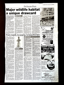
Work on paper - Major Wildlife Habitat: a unique drawcard. The Courier, Ballarat, 24/5/2001, From Marsh, to Swamp, to Beautiful Lake, 24/5/2001
The two articles are about Lake Wendouree, the first relates to the Lake as a major wildlife habitat and the second to the development of the Lake.Not only are there details of the Lake as a wildlife habitat, there is a detailed chronology and history of developments on and around Lake Wendouree.1 page of the Courier newspaper (p.5) with 2 major headings and a " Lake Timeline", 1/2 way down the page.Nonejohn garner, doctor john garner, ballarat botanic gardens, friends of ballarat botanical gardens, lake wendouree, wildlife habitat, yuille's swamp, ducks, grebes, native aquatic plants, white ibis, silver gull, possums, native water rats, history of lake wendouree., john garner collection, gardens, ballarat -
Friends of Ballarat Botanical Gardens History Group
Work on paper - Victoria Park Precinct, City of Ballarat, Victorian Heritage Database place details -19/9/2017, 19/9/2017
Victoria Park is associated with gold mining in the 1860's, military manoevres in the late 19th century; as an army base during World War 2 and a recreation area.Victoria Park is a "landmark cultural landscape" in the city of Ballarat. This parkland established 1890-1910, was modelled on English country estates and London Parks. It demonstrates the civic pride of Ballarat citizens and is an important parkland for the local community. There is a collection of exotic and early planted native trees and areas of native grasslands.6 pages of print. p.1. is a front page with a map and Victoria Park marked in purple with a bibliography on p.4 and footnotes on p.6.None.john garner, victoria park, friends of ballarat botanical gardens, heritage overlay, gold mining, parkland, late nineteenth century, native grasslands, exotic and native trees, royal park, mullock heap, mount holled-smith, arbor day, messrs clegg&nicholls, william guilfoyle, w.o.allen, significant tree register, john garner collection, gardens, ballarat -
Friends of Ballarat Botanical Gardens History Group
Work on paper - Victoria Park Precinct, City of Ballarat, Notes on the Parkland in the Nineteenth Century, Unknown
This page gives information about Victoria Park essentially from 1884-1894.Some idea is given here of Victoria Park back in history and plans for the planting of trees.1 page headed Victoria Park with a rough sketch of the Parkland area. There is an unfinished sentence at the bottom of the page and no page to follow.Nonejohn garner, doctor john garner, weston bates, george longley, curator, ballarat botanical gardens, night soil, ballarat council parks and gardens committee, gum trees, pines, victoria park, history friends of ballarat botanical gardens, john garner collection, gardens, ballarat -
 Friends of Ballarat Botanical Gardens History Group
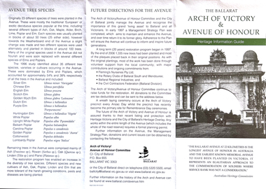
Work on paper - Heritage Information Guide, The Ballarat Arch of Victory and Avenue of Honour, 7/2007
This pamphlet provides comprehensive information on Memorials around Ballarat dating from May, 1917.Avenues of Honour are unique to Australia and found particularly Victoria. The Ballarat Avenue of Honour is of national importance as the longest and earliest known memorial tree planting of its type.This is an information pamphlet printed on both sides and folded into 3 sections. The headings are written in green and there is a black and white photograph of the Arch of Victory and the Avenue of Honour on the first fold. Over the page, there is a large diagram down the middle of the page, 2 black and white pictures of the righthand side and 2 sketches on the lefthand side of the page.None.john garner, doctor john garner, arch of victory, avenue of honour, heritage information guide, matilda l. thompson, tilly thompson, e.lucas &co pty.ltd, memorial wall project, memorial rotunda and roll of honour, memorial cairn and cross of remembrance, avenue trees and memorial plaques, ballarat city council., john garner collection, gardens, ballarat -
Friends of Ballarat Botanical Gardens History Group
Work on paper - "Most Begonias Survive Storm". Courier, Ballarat, Begonia Plants in the Ballarat Botanical Gardens
john garner collection, ballarat botanical gardens, gardens, ballarat, begonias, ballarat courier, courier, storm -
 Friends of Ballarat Botanical Gardens History Group
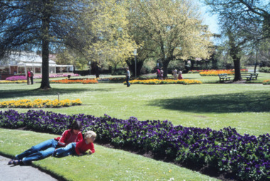
Photograph - Digital image TIFF, Old Begonia House, Ballarat Botanical Gardens
Colour photographballarat botanical gardens, begonia house, gardenscape, planting beds