Showing 225 items
matching proclamation
-
 Learmonth and District Historical Society Inc.
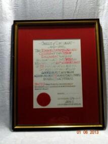
Certificate 125th Anniversary, Certificate to The Shire Of Ballarat,1863-1988,for 125th Anniversary, Circa 1988
Shire of Ballarat was Proclaimed in 1863 and to celebrate the 125th Anniversary,the City of Ballarat dedicated this certificate from the Mayor Councilors and Citizens of the city. Acknowledgement of 125th Anniversary of the Shire Of Ballarat.Rectangular frame with gold trim.Certificate is set in a burgundy mount and wording painted in red and green.SHIRE OF BALLARAT.1863-1988.THE MAYOR,COUNCILORS AND CITIZENS OF THE CITY OF BALLARAT WARMLEY CONGRATULATE THE SHIRE ON REACHING THE 125TH ANNIVERSARY OF ITS PROCLAMATION AND FOR THE PROUD RECORD OF GOOD GOVERNMENT AND HIGH ACHIEVEMENT IT HAS ESTABLISHED DURING THAT PERIOD. DATED THIS 24TH DAY OF NOVEMBER ONE THOUAND NINE HUNDRED AND EIGHTY EIGHT. Signed Mayor W.Chapman,Councilor A.E.Hancock,Chief Executive Officer A.R.Peile. certificate.125th anniversary shire of ballarat1988 -
 Bendigo Historical Society Inc.
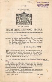
Book - 1954 VICTORIA ANNO TERTIO ELIZABETHÆ SECUNDÆ REGINÆ NO. 5842, 17/8/56
A small book owned by Accountant & Auditor Harold Curnow detailing the "Simplification of Title to and the Dealing with Estates and Interests in land for for other purposes", it also has the date 17/8/56 written in pencil on the top left corner. The first page is written as following. "17/8/56 Harold Curnow Accountant & Auditor Colonial Mutual Building View Point, Bendigo 1954 VICTORIA ANNO TERTIO ELIZABETHÆ SECUNDÆ REGINÆ No. 5842. An Act to amend and colidate the law relating to the Simplification of the title to and the Dealing with Estates and interests in Land and for other purposes. [14th December, 1954.] Be it enacted by the Queen's most Execellent Majesty by and with the advice and consent of the Legislative Council and the Legislative Assembly of Victoria in this present Parliament assembled and by the authority of the same as follows (that is to say) 1. (1) this Act may be cited as the Transfer of Land Act 1954. (Short title commencement and division) (2) (a) Save as otherwise ecpressly provided this act (except Division two of Part II.) shall come into operation on a day to be fixed by proclamation of the Governor in Council published in the Goverment Gazette. (b) Division two of Part II. shall come into operation on such later day as is fixed by proclamation of the Governor in Council published in the Goverment Gazette 6325/55 -Price 3s. 9d. (3) This"victoria -
 Federation University Art Collection
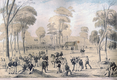
Print - Printmaking - Lithograph, Tulloch, David, 'Great Meeting of Gold Diggers Dec 15th 1851' by Thomas Ham, 1852
One of the first large goldfield meetings was at Castlemaine in 1851. After the extraordinary success of the Mt Alexander Diggings the Government issued a proclamation, raising the licence fee from thirty shillings to three pounds. As soon as these intentions became known a public meeting of miners was held. For miles around work ceased, with diggers travelling as far as Bendigo to attend the meeting. It is estimated that around 18,000 people attended the meeting. The notes with the engraving state The trees in this locality are chiefly Stringybark; some of them are peeled of their covering, as many persons prefer erecting bark huts to living in a comfortless tent. The various groups, and costumes of the men, are characteristic of our gold digging community. This item is part of the Federation University Art Collection. The Art Collection features over 2000 works and was listed as a 'Ballarat Treasure' in 2007.Colour lithograph of a meeting of diggers at a meeting in Mt Alexander. The meeting was the result of goldfields agitations against the license fee. lower centre "Great Meeting of Gold Diggers Dec 15th 1851" lower left side "Drawn By D. Tulloch" lower right side "Engraved by Thomas Ham"art, artwork, ham, thomas ham, tulloch, castlemaine, goldfields agitation, printmaking, edition, coloured lithograph, david tulloch, gold pan, shovel, wheelbarrow, waggon, bark hut, ring barked tree, gold mining -
 Clunes Museum
Document - CLUNES DOCUMENT
.1 CLUNES TOWN COMMON, 1861, REGULATION FOR THE TOWN COMMON .2 PETITION CLUNES MINERS - 1856 - 7 - PETETION OFMINERS, STOREKEEPERS AND OTHERS RESIDING IN CLUNES .3 BEER BILL, PETITION TO BE ABLE TO SELL ALVOHOL IN CLUNES 1860-1861 .4 PORT PHILIP AND COLONIAL GOLD MINING CAMP - COPY OF CORRESPONDENCE BETWEEN THE SOLICITOR GENERAL AND CLUNES MINING CAMP 1858 .5 LEGISLATIVE ASSEMBLY - EIGHTS REPORT OF THE PRINTING COMMITTEE 17/12/1861 .6 CROWN LAND BILL. PETITION TO WITHDRAW THE BILL AND REPLACE IT WITH A NEW BILL 1856-7 .7 PROCLAMATION OF GOLD FIELDS COMMON 1860-1clunes town common, minerspetition, beer bill, legislative assembly, crown land bill, gold fields common, john ferres -
 Bendigo Historical Society Inc.
Book - STREET AND ROAD MAPS OF THE CITY OF BENDIGO BOROUGH OF EAGLEHAWK, c1980
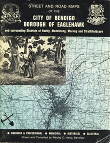
Street and Road Maps of the City of Bendigo Borough of Eaglehawk and surrounding Districts of Huntly, Mandurang, Marong and Strathfieldsaye, in color. Drawn and compiled by Wesley C Harry, Bendigo. Publisher: Cambridge Press, Bendigo. ISBN: 9598608.2.2. 68 pages. Photographs, Illustrations & maps. Photos include: Bendigo buildings, scenery mines, streetscapes, parades, pioneer leaders of Bendigo. Many advertisements throughout. List of Justices of the Peace, hospitals, homes for the aged, schools, churches. Page 58: Copy of ''Freedom of the City to the Australian Survey Regiment'' proclamation, 14th June 1970. Maps cover an area of some 169 sq. miles (43,772 hectares). Origin of the name Bendigo. Information on the five Wards of Bendigo, and their councilors.Wesley C Harrybook, bendigo, bendigo & district maps, bendigo and districts map, buildings, streetscapes, historical pictures, advertisements, historical information, commisioners camp, sandhurst -
 The Beechworth Burke Museum
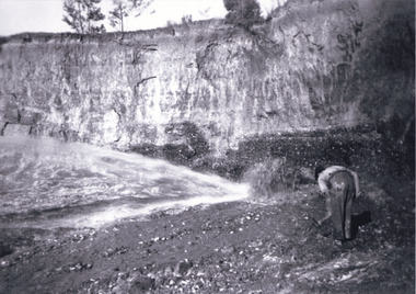
Photograph, c1920
This photo shows the large mining cavity with a hydraulic sluicing machine in operation at Baarmutha Three Mile Mine, Beechworth . The Beechworth Mining District was one of six mining districts established by the Governor-in-Council on 4 January 1858 under the provisions of An Act for Amending the Laws Relating to the Goldfields (21 Vic no.32). The District was further divided into seven divisions: Spring Creek, Snake Valley, Three Mile Creek, Buckland, Woolshed, Yackandandah and Omeo. The boundaries of each of these divisions and of the whole district are described in the Governor-in-Council's proclamation printed in the Government Gazette, 5 January 1858, pages 3-5. Hydraulic mining is a form of mining that uses high-pressure jets of water to dislodge rock material or move sediment. In the placer mining of gold or tin, the resulting water-sediment slurry is directed through sluice boxes to remove the gold. It is also used in mining kaolin and coal.This photograph shows the impact the gold rush era had on Australia and the earth.A black and white rectangular photograph printed on photographic paperCopied from original on loan film (WEBB QLD) / Donated 2009 NOV/ Baarmutha Three Mile Mine c1920-1950/ Managed by John Weir Peter Jereen Jack Cox / Owned by Plain Bros then Parkinsons Sluicing.mining, gold fields, beechworth, gold rush, burke museum, photograph, mining cavity, hydraulic mining, hydraulic sluicing, baarmutha -
 Wodonga & District Historical Society Inc
Photograph - Civic Leaders Wodonga 1876 - 1994
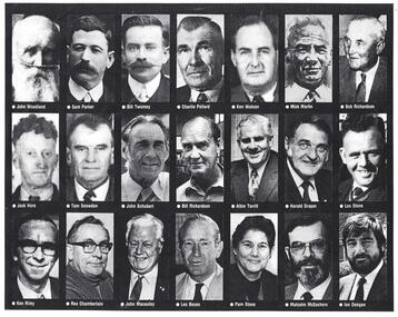
Wodonga Shire was created in 1876 when the colonial government agreed to ratepayers' petitions to have their part of the local government district severed from the Yackandandah Shire to form a new municipality. In March 1973 Wodonga was declared as the first Rural City in Australia. This was officially proclaimed by the Governor of Victoria, Sir Rohan Delacombe at and open-air ceremony in Hovell Street following a procession along High Street led by the Victorian Police Band. The first meeting of the held in the open air immediately after the proclamation. In 1994, the Jeff Kennett government restructured local government in Victoria. His reforms dissolved 210 councils and sacked 1600 elected councillors. Commissioners were appointed in their place. Wodonga’s Commissioners were Mel Reid, Des Kelly and Michael Hanson. Reforms introduced created 78 new councils through amalgamations. Democratically elected councillors returned to Wodonga in 1997, with Graham Crapp as Mayor.This item documents the leaders of local government in Wodonga since its inception in 1876 until Local Government reform in 1994.A photo collage representing Shire Presidents and Mayors of Wodonga, including a typed list of names and dates. All Shire Presidents and Mayors of Wodonga from 1876 – 1994 J. Woodland 1876-7, J. Bambrick 1877-78, G. Street 1878-79, W. L. Ferrier 1879-80, T. Reidy 1880-81, J. Bambrick 1881-82, A. Schlink 1882-83, T. Reidy 1883-84, N. P. Newnan 1884-86, J. Bambrick 1886-87, H. Harkin 1887-88, T. Johnston 1888-89, W.C. McFarlane 1889-91, P. Adams 1891-92, J. G. Shields 1892-93, H. Harkin 1893-94, W.C. McFarlane 1894-95, N. P. Newnan 1895-96, J. Bassett 1896-97, R. Morrison 1897-98, G. S. Manns 1898-99, H. Smith 1899-1900, H. Beardmore 1900-1901, G. Leighton 1901-02, J. H. McGeoch 1902-03, H. Beardmore 1903-1904, J. Whan 1904-05, A.E. Müller 1905-06, A. L. Wright 1906-07, J. H. McGeoch 1907-08, H. Beardmore 1908-1910, G. Leighton 1910-11, H. Beardmore 1911-1912, J. H. McGeoch 1912-13, G. Leighton 1913-14, H. Beardmore 1914-1917, S. T. Parker 1917-19, W. Twomey 1919-21, T. Ryan 1921-23, W. Twomey 1923-25, T. Ryan 1925-26, C. F. Pollard 1926-27, W. Twomey 1927-28, C. S. Street 1928-29, K. D. Watson 1929-30, M. Martin 1930-31, R, Richardson 1933-36, T. Ryan 1936-38, M. Martin 1938-39, R, Richardson 1939-41, J. S. Hore 1941-43, K. D. Watson 1943-45, C. F. Pollard 1945-47, C.C. Sheather 1947-48, T. E. Snowdon 1948-49, J. S. Hore 1949-50, G.A.W. Boyes 1950-52, D. J. Schubert 1952-54, V. R. Peard 1954-55, M. E. Morrison 1955-56, M. E. Morrison 1956-57, J. S. Hore 1957-60, D.J. Schubert 1960-61, A.B.S. Collins 1961-62, A. G. Richardson 1962-63, J. S. Hore 1963-65, J. A. Terrill 1965-67, H. W Draper 1967-68, J.A. Terrill 1968-71, *L.E. Stone 1971-74, K.T. Riley 1974-76, H. Draper 1976-77, Rex. Chamberlain 1977-80, H. W. Draper 1980-82, R. J. Macaulay 1982-84, L.O. Boyes 1984-85, **Pamela Stone 1985-86, M. McEachern 1986-87, R.J Macaulay 1987-88, I. Deegan 1988-89, Valentina Gillard 1989-90, R. J. Macaulay 1990-91, L. C. Boyes 1991-92, T. Corcoran 1992-94 *Last Shire President & first Mayor of the City ** First woman Mayor, Widow of L.B. Stonewodonga council, wodonga shire council, civic leaders -
 City of Kingston
Photograph - Colour, Paul Tresize, 1998
The name Mordialloc was derived from the name Moody Yallock, which comes from the Bunurong language. The Bunurong Peoples are the Traditional Owners of this area. The name means “high water” or “high creek”. In 1839, colonial authorities declared the mouth of the creek, and an additional 830 odd acres as an Aboriginal Reserve, although this proclamation was never gazetted. The reserved land included part of the Carrum Carrum Swamp which was abundant with wild life and natural resources. Regular encroachments, including land sales which began in 1863, were made on the land until 1878 when the Reserve was declared closed, and the land was opened up to land sales. Market gardening and suburban house lots quickly began to develop, and Mordialloc became a renowned picnic and holiday site. Mordialloc Creek is a popular bay side destination for local and visitors, and is a site for boating, kayaking, fishing and swimming, along with many other activities.Colour photograph of Mordialloc Creek, looking out to the bay. Many small fishing and leisure craft are moored on either side of the banks of the creek. To the right hand side can be seen parklands, while the left hand side has a small inlet in which more small crafts are moored.mordialloc, bunurong, traditional owners, suburbs, boats, fishing, waterways -
 City of Kingston
Photograph - Colour, 1998
The name Mordialloc was derived from the name Moody Yallock, which comes from the Bunurong language. The Bunurong Peoples are the Traditional Owners of this area. The name means “high water” or “high creek”. In 1839, colonial authorities declared the mouth of the creek, and an additional 830 odd acres as an Aboriginal Reserve, although this proclamation was never gazetted. The reserved land included part of the Carrum Carrum Swamp which was abundant with wild life and natural resources. Regular encroachments, including land sales which began in 1863, were made on the land until 1878 when the Reserve was declared closed, and the land was opened up to land sales. Market gardening and suburban house lots quickly began to develop, and Mordialloc became a renowned picnic and holiday site. Mordialloc Creek is a popular bay side destination for local and visitors, and is a site for boating, kayaking, fishing and swimming, along with many other activities.Colour photograph of Mordialloc Creek, looking inland.Small fishing and leisure boats are moored on either side of creek, with a view of the Mordialloc Bridge Hotel in the background.mordialloc, bunurong, traditional owners, suburbs, boats, fishing, waterways, hotel -
City of Kingston
Photograph - Colour, Paul Tresize, 1998
The name Mordialloc was derived from the name Moody Yallock, which comes from the Bunurong language. The Bunurong Peoples are the Traditional Owners of this area. The name means “high water” or “high creek”. In 1839, colonial authorities declared the mouth of the creek, and an additional 830 odd acres as an Aboriginal Reserve, although this proclamation was never gazetted. The reserved land included part of the Carrum Carrum Swamp which was abundant with wild life and natural resources. Regular encroachments, including land sales which began in 1863, were made on the land until 1878 when the Reserve was declared closed, and the land was opened up to land sales. Market gardening and suburban house lots quickly began to develop, and Mordialloc became a renowned picnic and holiday site. Mordialloc Creek is a popular bay side destination for local and visitors, and is a site for boating, kayaking, fishing and swimming, along with many other activities.Colour photograph of Mordialloc Creek, looking inland. Boats are moored on either side of the creek and the Bridge Hotel is visible in the background.mordialloc, bunurong, traditional owners, suburbs, boats, fishing, waterways, hotel -
 City of Kingston
Photograph - Colour, Paul Tresize, 1998
The name Mordialloc was derived from the name Moody Yallock, which comes from the Bunurong language. The Bunurong Peoples are the Traditional Owners of this area. The name means “high water” or “high creek”. In 1839, colonial authorities declared the mouth of the creek, and an additional 830 odd acres as an Aboriginal Reserve, although this proclamation was never gazetted. The reserved land included part of the Carrum Carrum Swamp which was abundant with wild life and natural resources. Regular encroachments, including land sales which began in 1863, were made on the land until 1878 when the Reserve was declared closed, and the land was opened up to land sales. Market gardening and suburban house lots quickly began to develop, and Mordialloc became a renowned picnic and holiday site. Mordialloc Creek is a popular bay side destination for local and visitors, and is a site for boating, kayaking, fishing and swimming, along with many other activities.Colour photograph of Mordialloc Creek with boats moored on both sides of the street and Pompei's boat yard visible on the right hand side of the creek., Main Street and St Brigid's Catholic Church are visible in backgroundmordialloc, bunurong, traditional owners, suburbs, boats, fishing, waterways, hotel, church -
City of Kingston
Photograph - Colour, Paul Tresize, 1998
The name Mordialloc was derived from the name Moody Yallock, which comes from the Bunurong language. The Bunurong Peoples are the Traditional Owners of this area. The name means “high water” or “high creek”. In 1839, colonial authorities declared the mouth of the creek, and an additional 830 odd acres as an Aboriginal Reserve, although this proclamation was never gazetted. The reserved land included part of the Carrum Carrum Swamp which was abundant with wild life and natural resources. Regular encroachments, including land sales which began in 1863, were made on the land until 1878 when the Reserve was declared closed, and the land was opened up to land sales. Market gardening and suburban house lots quickly began to develop, and Mordialloc became a renowned picnic and holiday site. Mordialloc Creek is a popular bay side destination for local and visitors, and is a site for boating, kayaking, fishing and swimming, along with many other activities.Colour photograph of Mordialloc Creek with boats moored on both sides of the street and Pompei's boat yard visible on the right hand side of the creek., Main Street and St Brigid's Catholic Church are visible in background.mordialloc, bunurong, traditional owners, boats, fishing -
 Glen Eira City Council History and Heritage Collection
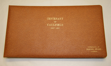
Album - Album, photographic, "Centenary of Caulfield, 1857- 1957", c. 1957
The 100th anniversary of the proclamation and declaration of the "Caulfield Road District" was held on 15 October 1957. A variety of public events were organised to celebrate this memorable occasion between 13 October and 8 November 1957. The "Centenary of Caulfield 1857-1957" photograph album which contains annotated images of these events is considered of great historical importance as a unique record of Caulfield events, people and places during this time. The Caulfield Centenary events were held between 13 October and 8 November 1957. Key participants included the Mayor of the City of Caulfield, Councillors, officers, and a wide range of community groups. The events included: a special Centenary Council Meeting at the Town Hall on 15 October; an opening ceremony; two receptions; two religious services; a naturalisation ceremony; an evening community float parade; a children's carnival at Caulfield Racecourse; the crowning of Centenary Queen and an impressive fireworks display. Light brown leather bound photograph album with embossed in gold lettering on the front and centre of the Album. Contains a series of annotated B/W photographs taken as part of the Centenary of Caulfield celebrations which took place in the local area including the Caulfield Town Hall between 13 October and 8 November 1957. portico"Centenary of Caulfield 1857-1957 Photography by Hermes Studio Carnegie"caulfield road district, anniversary, centenary, 1957, city of caulfield -
 Bendigo Historical Society Inc.
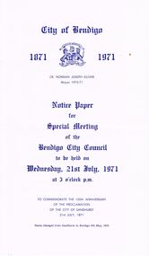
Document - BENDIGO CITY COUNCIL: NOTICE PAPER FOR SPECIAL MEETING 21/7/1971, 21st July 1971
(Seven paged) Notice Paper for Special Meeting (Bendigo City Council) 21/7/1971 to commemorate the 100th anniversary of the proclamation of the City of Sandhurst. Three copies (7702.a - 7702.c) Includes 'Council Summons'; list of Members of Council; Agenda for Special Meeting; photographic copy of extract from the Victoria Government Gazette (21/7/1871); reproduction photos of Town Hall, 1871, Cr J Boyd first Mayor and Cr. N Oliver , current Mayor; list of Chairmen of the Municipality (1855-1863), Mayors of the Borough (1863-1870-, Mayors of the City of Sandhurst (1871-1891), Mayors of the City of Bendigo (1891- 1971), List of Town Clerks (1856- 1971); (formal) Notice of Motion.Combridge Pressbendigo, council, council meeting, list of council members, mayor cr. j. boyd, cr. norman joseph. oliver, lyttleton terrace, mayor's of city of sandhurst. mayor's of city of bendigo. -
 Bendigo Historical Society Inc.
Book - STREET AND ROAD MAPS OF THE CITY OF BENDIGO BOROUGH OF EAGLEHAWK, c1980
Street and Road Maps of the City of Bendigo Borough of Eaglehawk and surrounding Districts of Huntly, Mandurang, Marong and Strathfieldsaye, in color. Drawn and compiled by Wesley C Harry, Bendigo. Publisher: Cambridge Press, Bendigo. ISBN: 9598608.2.2. 68 pages. Photographs, Illustrations & maps. Photos include: Bendigo buildings, scenery mines, streetscapes, parades, pioneer leaders of Bendigo. Many advertisements throughout. List of Justices of the Peace, hospitals, homes for the aged, schools, churches. Page 58: Copy of ''Freedom of the City to the Australian Survey Regiment'' proclamation, 14th June 1970. Maps cover an area of some 169 sq. miles (43,772 hectares). Origin of the name Bendigo. Information on the five Wards of Bendigo, and their councilors. Revised Edition 1986Wesley C Harrybook, bendigo, bendigo & district maps, bendigo and districts map, buildings, streetscapes, historical pictures, advertisements, historical information, commisioners camp, sandhurst -
 Melbourne Tram Museum
Legal record, Hawthorn Tramways Trust (HTT), "Hawthorn Tramways Trust - By-Law No. 2", "Protection of Native Game at 'Wattle Park' Surrey Hills", Original 1917
Set of two extracts from the Victorian Government Gazette, printed onto A4 sheets concerning Wattle Park. .1 - "Hawthorn Tramways Trust - By-Law No. 2" - By-law Regulating, Controlling and Managing Wattle Park - Gazette of 29 August 1917, page 2714. Signed by D. Dureau, H. Bell and A Hislop of the HTT 21/8/1917. Gives the rules for the use of the park. Replaced by MMTB By-Law No. 7 - see Reg item 2019. .2 - "Protection of Native Game at 'Wattle Park' Surrey Hills" - Proclamation - The Game Act 1915 - Gazette of 9/5/1917, page 1418. Gives the location details and refers to the Act. Note these Gazettes can be sourced from the Victorian Government Parliament Web site.trams, tramways, wattle park, htt, by laws, regulations -
 Melbourne Tram Museum
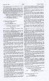
Document - Notice, Government of Victoria, Tramway Board appointment of Members, Jan. 1916
Set of three notices printed on large sheets, extract from Govern Gazettes and other Parliamentary or Department of Public Work notices. .1 - Dated 18/1/1916 - appointment of Members of the Tramway Board - Colin Templeton, Sir David Greenness, Sir Henry Weedon, F. T. Hickford and Alex Renfrew. Signed by F. W. Mabbott, Clerk of the Executive Council. .2 - Dated 26/1/1916, giving notice of the first meeting of the Tramway Board and its members. To be held on 28/1/1916 at Dominion Chambers, 59 William St. Signed by F. W. Mabbott, Clerk of the Executive Council. .3 - Proclamation - dated 17/2/1916 advising the date of the dissolution of the Melbourne Tramways Trust - by Sir Arthur Stanley, Governor and W. Hutchinson, Commissioner of Public Works.trams, tramways, tramway board, government gazette, melbourne tramways trust, mtt -
 Kew Historical Society Inc
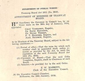
Painting - John Halfey, c.1882
John Halfey (1825-89) was born in Southport, Lancashire and migrated to Victoria in 1852. After finding gold at Sandhurst, and representing the latter in the Victorian Parliament, he moved to Melbourne to engage in various commercial pursuits, including directorships of insurance, mining and banking companies. A resident of Kew from the late 1850s, he was known for the hospitality provided at his house Ordsall (later Southesk) in Cotham Road. On 14 December 1860, Halfey chaired a public meeting calling for separation from the Boroondara Roads Board, which led, four days later, to the proclamation of Kew as a separate municipality. He was elected to the Council in 1861, replacing Cr. Oswin, and subsequently served as the second Chairman of the Municipality in 1862-1863. John Halfey became a trustee of Holy Trinity Church in Bulleen Road (now High Street) in 1862. He was to resign from Council after four years in 1865. Twenty-four years later in January 1889, he died aged 63 from a seizure, at his rooms at the Herald Office. He was interred in the Boroondara General Cemetery where his monument is the tallest in the Cemetery. Donated by Eileen Grigg, 2017Small, full-length portrait of John Halfey in an original gilded frame. The artist depicts him formally dressed in a frock coat beside an open window. He is shown holding a document or perhaps a pair of gloves. The painting is badly damaged with a hole in the area of his face that has been patched and repainted.john halfey, ordsall, chairman of kew, boroondara roads board, municipality of kew -
 Bendigo Historical Society Inc.
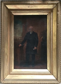
Book - 1958 VICTORIA ANNO TERTIO ELIZABETHÆ SECUNDÆ REGINÆ NO. 6284, 23/2/60
A small book owned by Accountant & Auditor Harold Curnow dated 23/2/60 detailing "An Act to consolidate the Law relating to the Sale and Occupation of Crown Lands." on page 61 it also has a 2/10/61 newspaper article and a June 27, 1962 page from the Victoria Gazette both of them detailing the Laws. The first page is written as following "Harold Curnow 1958. VICTORIA ANNO SEPTIMO ELIZABETHÆ SECUNDÆ REGINÆ No. 6284. An Act to consolidate the Law relating to the Sale and Occupation of Crown Lands, [30th September, 1958.] Be it enacted by the Queen's Most Execellent Majesty by and with the advice and consent of the legislative Assembly of Victoria in this present Parliament assmled and by the authority of the same as follows (that is to say) 1. This act may be cited as the Land Act 1958. and shall come into operation on a day to be fixed by proclamation of the Governor in council published in the Goverment Gazette, and is divided into Parts Divisions and Subdivisions as Follows:-"victoria -
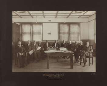 Bayside Gallery - Bayside City Council Art & Heritage Collection
Photograph - gelatin silver photograph, Sarony & Co, The first meeting of the City of Sandringham Council, 21st March, 1923, 1923
Photograph taken on the day that the Town of Sandringham became a City, and the first meeting of the City of Sandringham Council. Sandringham was originally part of the Shire of Moorabbin. On 28 February 1917, Sandringham was severed from Moorabbin and incorporated as the Borough of Sandringham. It was proclaimed a Town on 9 April 1919 and a City on 21 March 1923.councillor, sandringham, local government, municipality, mayor, cr. c.a. hartsman, cr. t.g. farrant, cr. g.w. knott, cr. f.n. gibbs, h.t. williams, town clerk, engineer, cr. j.t.d. beck, b.r. sunderland, cr. w.h. kay, cr. r. chisholm, cr. h.b. grace, cr. j.m. ramsay, city, proclamation, council meeting, city of sandringham -
Glen Eira Historical Society
Book - CAULFIELD CENTENARY 1957
This file contains four items 1/Two copies of a twenty-four page booklet titled CITY OF CAULFIELD CENTENARY 1857-1957, created by the Caulfield City Council and printed by Peter Isaacson Pty Limited, Melbourne. The booklet details important aspects of Caulfield’s history including council procedures, the Caulfield Road District Proclamation, the first election and a summary of 100 years of local government with a description of the present Caulfield in 1957. The booklet also includes several pictures of various Caulfield landmarks and people including one of Caulfield City Councillors (11 men and 1 woman). Also one photocopied version of this booklet. 2/Eleven pages of typed notes for the City of Caulfield Centenary booklet. All notes are undated and incomplete. Two pages titled NOTES on THE HISTORY and PROGRESS OF THE CITY OF CAULFIELD, author unknown. Three and a half pages titled THE STRUCTURE OF LOCAL GOVERNMENT IN VICTORIA, author unknown. Five pages titled 100 YEARS OF LOCAL GOVERNMENT – EARLY CAULFIELD, by Mrs A. P. Bell. 3/A typed letter to Miss V. Webb-Langdon from the Town Clerk H.G. Nelson, acknowledging her contribution to historical details for the Caulfield Council’s Centenary booklet, dated 24/12/1957. 4/A handwritten letter and a handwritten note regarding the acquisition of notes for the Caulfield Centenary booklet. The letter is dated 03/08/2006 and the note is dated 09/02/2007.city of caulfield centenary, caulfield road district, sinclair a.j.g., city hall, war memorials, gamble h.a., machin l.r., bunny f.c.d., caulfield park, koornang reserve, parton e.m., sims h.e., thomson w.r., gunn e.e., yorston j.s., wallace g.e. mrs, green w.c., jenner e.r., ward boundaries, dandenong road, queens avenue, normanby road, station street, bond street, glen eira road, orrong road, poath road, north road, booran road, nepean highway, glen huntly road, glenhuntly road, inkerman road, hotham street, nelson h.g., fullard w.r., mackley g.j., ellis k.i, crosbie m.r., nutting b.i., body j.h., pritchard r.j., guildford l.t.g., lund l.m., street h.c., reynolds a.w., elections , political processes, local government, springthorpe reserve, greenmeadows gardens, business and finance, roads and streets, caulfield racecourse, east caulfield reserve, mackinnon reserve, hawthorn road, balaclava road, murrumbeena road, lempriere avenue, victoria street, koornang road, lord reserve, lyons street, murrumbeena reserve, kangaroo road, ormond park, beatty crescent, foch street, packer reserve, oakleigh road, leila road, prices park, bambra road, riley reserve, playgrounds, town hall, maternal and child health centres, truganini road, grange road, senior citizens centre, barkley sir henry, moore david, handasyde gilbert, caulfield school room, harris g.w., semple john, dempsey william, brooks w.a., wilson thomas, lyall william, murrum murrumbeen lifestyle, ‘greenmeadows’ house, lempriere family, aboriginal culture, ‘rippon lea’ house, caulfield john, ‘slaney’s’ home, alma road, paddy’s swamp, racecourse hotel, caulfield technical college, bevan mr., ‘grosmont’, hart john, railways, mansions, ‘rosecraddock’, langdon h. j., caulfield cup, ‘crotonhurst’, webb judge, ‘kilwinning’, service james, ricketson henry, ‘glen eira’, house names, garden vale, ross william murray, ‘ross’s folly’, outer circle railway, caulfield grammar school, davies j. henry, lagdon william, grimwade f.s., loyd charles du plan, hope george, ‘airdrie’, kooyong hill, market gardens, dairies, lady talbot milk supply, jenner family, o’niell college, presentation sisters, glenferrie road, grimwade frederick sheppard, grimwade alice, ‘harlston’, grimwade house, ‘saint aubin’s’, ‘st. aubin’s’, ‘caulfield hall’, caulfield john p.t., st georges road, caulfield military hospital, nursing homes, health establishments, dover street, sports and recreations, rosanna street, ‘cantala’, health services, parks and reserves, community services, town planning, local government finance, local officials and employees -
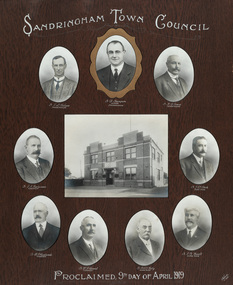 Bayside Gallery - Bayside City Council Art & Heritage Collection
Photograph - gelatin silver photograph, Talma & Co, Sandringham Town Council, Proclaimed 9th day of April,1919, 1919
Sandringham was originally part of the Shire of Moorabbin. On 28 February 1917, Sandringham was severed from Moorabbin and incorporated as the Borough of Sandringham. It was proclaimed a Town on 9 April 1919 and a City on 21 March 1923. The Sandringham Town Hall, located on Abbott Street, Sandringham (formerly the mechanics institute) was demolished in 1994.councillor, sandringham, local government, municipality, mayor, portrait, city of sandringham, sandringham town hall, abbott street, cr. e.l. belyea, cr. b. champion, cr. h.b. grace, cr. c.a. hartsman, cr. j.e.d. beck, cr. b.j. ferdinado, cr. t.g. farrant, cr. w.t.c. kelly, cr. g.w. knott, town, proclamation, bayside, hampton, black rock -
 Bendigo Historical Society Inc.
Book - JOAN O'SHEA COLLECTION: 150TH ANNIVERSARY OF BENDIGO BOOKLET, 1850 - 1950's
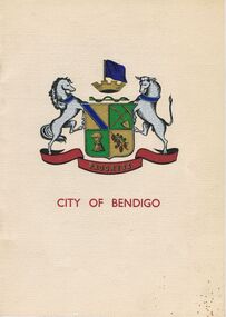
Joan O'Shea Collection. Buff Coloured Booklet City of Bendigo. 150th anniversary of Bendigo 1850s to 1950s. Image on cover coat of arms for City of Bendigo underneath word progress, left hand side horse, right hand side bullock. History of Bendigo: From Sheep Run to Provincial City in 100 years. Map of Bendigo and Surrounds Railways, Water Courses & Storage, Power, Municipal Boundaries & Land Available for Industry. Municipal District Creation 1855, Borough Proclamation 1863, Proclaimed City 1871, Area: 7992 Acres Population as of last census City of Bendigo 28,722, City of Bendigo and adjacent Urban Areas 36,909. City of Bendigo Map, The Past Prior to 1850. Icons of Bendigo The Bendigo base Hospital,Law Courts & Post Office, Primary Schools, Housing, Industry including Butter Production, Poultry Farming, Livestock Sales & Tomato Growing, Slaughter House & ordnance factory. The Present Recreation Photos: Bendigo Bowling Club, Queen Elizabeth Oval, Municipal Lawn Tennis Courts The Future of Bendigo, Bendigo Photographs From The 1950s,Cambridge Press Bendigobendigo, history, progress of bendigo 1850s on. -
 Ballarat Heritage Services
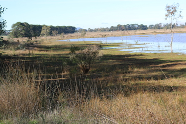
Photograph - Digital photograph, Dorothy Wickham, Winter's Swamp, Ballarat, January to April 2014
Study of Winter's Swamp commissioned by BEN and completed by BHS. The swamp was named after one of the first European settlers in the district. Winter Swamp LAT -37 32 LONG 143 47, Parish of Dowling Forest, County of Grenville Winter Swamp, on the southwest corner of Ballarat West Town Common, was not included in the original proclamation of the Common in 1861. However, being marshland, it was not considered suitable for grazing, so was added to the Common soon after 1861. Winter Swamp is a large wetland with native and exotic pasture significant for wildlife. John Winter (Jock) was born in Berwickshire, Scotland. He married Janet Margaret Irving the daughter of Robert Irving, advocate, Bonshaw, Dumfries, Scotland. Winter died in Ballarat in 1875 and was buried at the Ballaarat Old Cemetery. He took up the run Bonshaw from 1841; Leigh River Buninyong 1842-46; Junction, Delatite, March 1851 to September 1862; with sons: Carag Carag and Corop, April 1857 to September 1872; Colbinabbin and Stewart’s Plains, April 1857 to December 1872; St Germains February 1867 to March 1871. (The name became Winter-Irving in 1890). Mr John Winter, who died on August 22 at the age of 72, was a man of some note it the mining community of Ballarat. He was a self-made man, and one of our oldest colonists, it being over a quarter of a century age since he took up county about Ballarat and settled at Bonshaw. He died very rich. It is calculated that if he had retained an interest in all his runs, his income must have been not less than £10,000 or £50,000 a year. Some eight or ten years ago he sold his Bonshaw pre-emption to the Bonshaw Gold mining Company for £20,000, and a few years later the ground belonging now to Winter's Freehold Company brought him £50,000 more, the payment being made at the requisition of the deceased in sovereigns. In these relations Mr. Winter has been closely identified with the mining industry at Ballarat. The deceased was a native of Lauder, in Berwickshire, and landed in Victoria several years before the gold discovery.The principle task of this project was the delivery of a report outlining the history of European settlement in the Skipton and Cardigan/Ballarat districts as pertinent to the use of and impact on the natural environment of the two reserves Skipton Common and Winter Swamp. The report was delivered in digital form only. The report, upon completion, was presented to the Network’s Committee in order to discuss the project. The report identified and described the uses of Skipton Common and Winter Swamp, and their impacts. In particular, this report examined farming/grazing (official and informal), mining, vegetation removal (including the removal of woodlands for timber, grasslands for pasture improvement) & use of riparian areas for access to water and timber removal. Recording the more benign and environmentally friendly uses such as picnicking, community activities, nature walks and the roles of organisations such as Field Naturalists’ and Bird Observers’ clubs, school and scout/guide groups will be relevant in helping to depict overall community attitudes towards the reserves; e.g.: has the Common generally been viewed as little more than a grazing paddock and fire hazard; has Winter Swamp always been the unknown natural asset that seems to have been its lot for at least the past 40 years? In this regard, the more contemporary history of actions surrounding the use and management of the reserves is of particular interest, in view of the extant evidence at both reserves; e.g. the actions of the Shire of Ballarat in the 1980s in establishing Winter Swamp as something of a competitor to Lake Wendouree but with a more environmental bent (although almost none of the plants used are indigenous species, but that is part of the story); the trotting track constructed on Skipton Common in the 1960s following representations to Premier Henry Bolte and the cropping of the western section of the Common to raise funds for the town’s new swimming pool, the fertilizing of the land putting an end to the native grassland vegetation. There are obviously multiple sources of information to source in preparing the report, however sources that the contractor is specifically requested to consult are the Skipton Historical Society, the former Skipton Common managers (specifically Graeme Pett), the Cardigan Windermere Landcare Group and the Learmonth Historical Society (believed to hold many of the former Shire of Ballarat’s records pertaining to the Council’s role as the Committee of Management for both Winter Swamp and the Ballarat West Town Common – Winter Swamp was split between 2 separate Crown Land tenures). The contractor is also encouraged but not required to utilise community newsletters, such as the Skipton Community Newsletter, to publicise and seek information about the project. Skipton Historical Society (Mary Bradshaw) contacted on Thursday 12 June 2.30pm. Mary lived on a farm out of Skipton but is currently living in the township. She remembers walking along the creek of the Common especially in spring and autumn in bare feet and that it was a very pretty place. There were a few snakes around the waterway in summer. People put cows and a couple of horses on the commonage to graze. Graeme Pett has always lived close to the Common and would know a lot about it. Other possible contacts would be Nicole Petress, Secretary of the Progress Association, and the Corangamite Council, Camperdown. Digital images of Winter's Swampwinter's swamp, ballarat, john winter, ballarat environmental network, mullawullah -
Glen Eira Historical Society
Letter - CAULFIELD CENTENARY - 1957
This file contains seven items: 1/One double sided pamphlet regarding the Caulfield Centenary Carnival at Caulfield Park from 25/10/1957 to 05/11/1957, listing attractions and special events. Includes advertising for Bunny Industries on the back. 2/One pamphlet for the Children’s Carnival at Caulfield Racecourse on 29/10/1957 as part of the City of Caulfield Centenary celebrations. The pamphlet includes a timetable for the day’s events. 3/One six page pamphlet for a film festival organised by the Caulfield Film Society as part of the City of Caulfield Centenary Celebrations. The pamphlet includes a programme for each of the four days of the film festival, 14/10/1957, 17/10/1957, 23/10/1957 and 25/10/1957. The pamphlet also includes information about the Caulfield Film Society regarding their formation, their values, their manifesto and their officials. 4/An eight page programme for the centenary Thanksgiving Service on 13/10/1957 featuring prayers and hymns. 5/Two copies of a pamphlet regarding City of Caulfield Centenary Celebrations from 13/10/1957 to 05/11/1957 created by H.G. Nelson, Town Clerk. Events listed include Thanksgiving Service, Music Festival, Film Festival, Special Centenary Council Meeting, Gymkhana, Parade of Decorated Floats, Spring Flower Show, Massed Bands Display, Display of Art, Naturalisation Ceremony, Solemn High Mass, carnivals and plaque unveiling. 6/One original and one photocopy of an eight page notice paper for the Special Meeting of Caulfield City Council to commemorate the 100th Anniversary of the proclamation and declaration of the Caulfield Road District, to be held on 15/10/1957. The booklet includes the agenda, a council summons, a picture of Caulfield’s City Hall and a list of current and past councillors, chairmen, presidents, mayors and Shire Secretaries and town clerks. 7/A letter addressed to F. Campbell from Hazel Da Costa, dated 07/11/1997 regarding the acquisition of pamphletts for the Caulfield Centenary Carnival. For further information refer to the Oakleigh and Caulfield Times 09/10/1957 and Caulfield-Elsternwick Advertiser 05/11/1957 and 22/10/1957 stored in the Newspaper Archive room 4.caulfield centenary carnival, queen crowning ceremony, dandh bunny pty ltd, caulfield film society, carnegie memorial hall, caulfield park, hawthorn road, balaclava road, glenhuntly road, parades and processions, fire works displays, festivals and celebrations, bunny industries, glen press, hardware stores, builders suppliers, plumbers suppliers, centenary celebration, caulfield centenary, children’s carnival, caulfield racecourse, sinclair a.j.g., sporting events, film festival, new supper room, town hall, methodist hall, saint john hall, birch street, orrong road, princes park, caulfield hospital, daughters e.f., ward miss n., madigan mr. r, ritchie miss e., weichelt mr f., machin l.r., green w.c., jenner e.r., thomas w.r., centenary thanksgiving service, hymns, prayers, naturalisation ceremony, caulfield and district horses and pony club, special centenary council meeting, caulfield horticulture society, saint aloysius church, packer reserve, oakleigh road, caulfield memorial youth centre, commemoration, caulfield road district, mayors, presidents, chairmen, councillors, town clerks, parton e.m., bunny f.c.d., sims h.e., thomson w.r., wallace g.e., gunn e.e., gamble h.a., yorston j.s., handasyde g., murry ross w., stephen j.w., masters s., lloyd j.c., watts thos., watts t., nelson c., webb g.h., stephen f.j., crosbie j.w., watts w.c., holland j.c., lempriere w.g., millar w., newing t. r., ballantyne j., cotton a.d., long j., kirkham c.f., lloyd c.du p., wood f.g., akhurst a.c., riddell w.j.c., sharp t.c., phillips r.l., lempriere j.t., bayston w.s., dunbar a., hall p., saint j., fiske w., thompson h., murphy e.c., eggleston f.w., murray n.l., wood h.s., tyner w., wharington w.a., packer j.t., falls t., brooks w.r., lord r.h., morris a.e., page j.w., porter f.w., england e.f.s, patton r.t., mcculloch r., richie h.g., packer j.t., mackinnon d.c., mackinnon g.a., smith h.c.h., shillabeer f.e., pullman c.a., stewart l.mcr., tyers s.w., morris t.w., prior p.l., brooks w.r., webster h.c., sims h.e., prior p.l., thomson w.r., gunn e.e., parton e.m., wallace g.e., dempsey w., hart j., jowett f., briggs j.r., nelson h.g. -
Ringwood and District Historical Society
Envelope, Packet 3 St Paul's Anglican Church, Ringwood, Circa 1920s-1990s
Various newsletters and local church records circa 1920s-1990s as follows: 4940-01 Parish Messenger – Easter 1927 4940-02 Parish Messenger – April, No.42 4940-03 Anglican News – November, No.15 4940-04 Parish Paper – April 1937 4940-05 Parish News Supplements – June 1969, August 1969, September 1969, April 1977 4940-06 List of Memorials in St. Paul’s Ringwood - 1971 4940-07 Civic Service, 30th Anniversary City of Ringwood – June 1990 4940-08 Opening and dedication of “Glamorgan Court” - 1989 4940-09 Civic Service Commemorating Proclamation of City of Ringwood – 20th March 1960 4940-10 Institution and Induction of The Reverend Douglas G. Edmonds - 12th December 1989 4940-11 Last Service at St Paul’s in Ringwood Street – 28th May 1967 4940-12 Catalogue, Art Exhibition – March/April 1979 4940-13 (duplicate entry deleted) 4940-14 Parish News “Spiritus Gladius” Centenary Celebration - 1979 4940-15 St.Paul’s Centenary Worship – 14th October 1979 4940-16 Service/Newsletter pamphlets - January to April 1996 (incomplete collection) 4940-17 Advertisement for New Theatre "Polling Day" concert at church hall (near Post Office) - 1961 4940-18 Commissioning of Penny Charters, Janice Dear, and David Jones as students in ministry 4940-19 Funeral Service for late Floss Davidson (Ms. V. Boulter) 19 January 1979 4940-20 Service of Thanksgiving for Rev. John & Mrs. Helen Howells - 18 June 1989 4940-21 Bush Church Aid 70th Anniversary, St Paul's Ringwood - 1 October 1989 4940-22 Parish Baptism, Confirmation and Eucharist - 12 November 1989 -
 Uniting Church Archives - Synod of Victoria
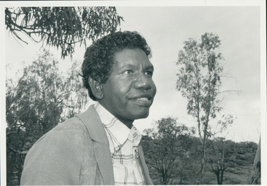
Photograph, Rev. Djiniyini Gondarra, 1986
Rev Dr Djiniyini Gondarra OAM, was born in Milingimbi, eastern Arnhemland in 1945. He was educated at Milingimbi Mission School and pursued his theological education as a youth leader and Sunday School teacher through the Methodist Church, before attending college in Brisbane. In 1969 he trained as a Minister in Papua New Guinea and the Solomon Islands under the Uniting Church, before returning to Arnhemland to minister his own people at the Galiwin’ku parish, firstly as a lay pastor (1971-1972) and then as a Minister from 1976-1982. In 1983-84, Rev Djiniyini worked as a Lecturer in Theology at Nungalinya College, Darwin. He was honoured with a Diploma of Theology (Honorary) from there in 1984, and in 1991 received a Cultural Doctorate in Literature (Honorary) from the World University, Roundtable, Arizona USA. Rev Djiniyini was awarded the Order of Australia Medal (OAM) in 1995. As well as being the Chairman of ALPA since 1993, Rev Djiniyini is currently the Director of Duduy’ngu Pty Ltd, which provides consultancy and cross-cultural services. He is also Director of Yirrkala Business Enterprises. Over the years, Rev Djiniyini has served on many committees and councils including: Member of the Steering Committee of the Australian Indigenous Cultural Network (1998-2001), CEO of Aboriginal Resource and Development Services Inc (1998-2001), CEO of the Northern Regional Council of the Uniting Aboriginal and Islander Christian Congress (1998-2001), Director of Reconciliation Australia Limited (2000-2001), Member of Council for Aboriginal Reconciliation (1998-2000), Chairman of Uniting Aboriginal and Islander Christian Congress (1995-2000 & 1990-1993), Member of Central Committee of the World Council of Churches (1991-1994), Moderator of Northern Synod, Uniting Church in Australia (1985-1987), Secretary of newly formed Aboriginal Presbytery, Northern Synod, Uniting Church in Australia (1985), and Vice-President of Uniting Aboriginal and Islander Christian Congress Uniting Church in Australia (1983-1987). Rev Dr Djiniyini Gondarra OAM has also been extensively published, and his works include: • Information Papers (co authored), Aboriginal Resource and Development Services: • Confusion Between Cultures (1998) • MHead & Shoulders of Djiniyini Gondarra facing right of picture."Rev. Djiniyini Gondarra 1986. Moderator Northern Synod and Vice President of Uniting Aboriginal and Islander Christian Conference."gondarra, djiniyini, uaicc, northern synod uca -
 Flagstaff Hill Maritime Museum and Village
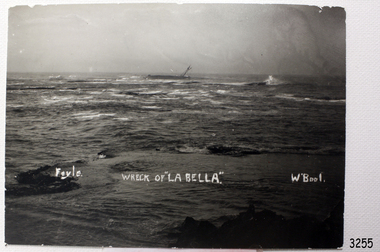
Photograph, Foyle Photographic Studio, Wreck of La Bella, about 11/11/1905
The photograph shows the wreck of La Bella in Lady Bay, Warrnambool, Australia. It was probably taken on 11th November 1905, the morning after she was wrecked. “Foyle” written on the photograph is the name of Foyle’s Photographic studio. At the time of the photograph the studio was owned by both Charles and Lilian Foyle (sometimes known as Lillian or Lily), either of whom could have taken this photograph. They also worked together at a later date on the photographs, sketches and paintings of the famous and historical Pioneers’ Honour Board, which is currently on view in the Warrnambool Library. Foyles Photography was the studio of James Charles Foyle. He owned “Foyle’s Photo Card Studios” in Liebig St , Warrnambool, which operated between 1889 – 1919 . A letter to the editor (by Mr Edward Vidler) in the Melbourne Argus, 3rd August, 1907, mentions that in that year Warrnambool would celebrate its 60th anniversary of its proclamation as a town, and that talented local artist Miss Lily Foyle would paint 200 portraits in watercolour of the pioneers who settled in the district prior to 1860. The Pioneer Honour Board can still be seen on display in the Warrnambool Library. In the Warrnambool Standard, Dec. 1917, “Mr Foyle’s studio was awarded contract to decorate rail cars on newly opened Trans-Continental railway, assisted by his sister, Miss Findlay.” The subject of the painting, La Bella, has its own tragic story. Read on for further details … On November 10th, 1905, the Norwegian-built barquentine La Bella approached Warrnambool at the end of her 37 day voyage. She was carrying a cargo of timber from Lyttleton, New Zealand, in heavy seas and evening mist. (On its only other visit to Warrnambool a year earlier the master had gone to shore to find a tow. He returned to the ship to find the crew drunk and unwilling to take up their posts, even though the ship was dragging its anchors and in a dangerous position.) As Captain Mylius steered La Bella to Lady Bay Channel the ship was tossed onto its side by heavy breakers and ran aground on what is now known as La Bella Reef. The sea was so rough that it wrenched a one-and-a- half ton anchor from the vessel. Several attempts were made by parties of volunteers in lifeboats to rescue the stricken sailors, but the rough conditions made this difficult for the boats to get close enough to the ship and the parties had to return to shore. The La Bella’s crew became exhausted and sailors were being washed overboard, one by one. By sunrise only five of the twelve crew still clung to the wreck. A local fisherman, 25 year old William Ferrier, rowed his small dingy through the heavy seas and managed to rescue the captain, whilst the volunteer lifeboat crew rescued a further three sailors, returning to shore. Ferrier made a final attempt at rescue and was able to reach its stern as the conditions eased slightly, saving the last remaining, terrified sailor just before the ship broke up and sank. William Ferrier became a national hero as news of the daring rescue spread. He was awarded the Silver Medal for bravery by the Royal Humane Society and was honoured by the Prime Minister and the Governor. He was presented with several other awards for his daring rescue. Ferrier’s rescue efforts are one of the most heroic in Victoria’s shipwreck history. The wreck now lies in 13m of water and is home to an abundance of marine life. Flagstaff Hill’s La Bella Collection includes a rail holder from La Bella, a photograph of William Ferrier with four of the five men rescued, a rail holder from the ship and the letter from the Prime Minister and other Members of Parliament that was sent to William Ferrier to commend him for his bravery. La Bella has been protected under the Commonwealth Historic Shipwrecks Act (1976) as a Historic Shipwreck since 23 April 1982 (VHR S401). It is archaeologically significant as the remains of an international and inter-colonial passenger and cargo ship. Flagstaff Hill’s collection of artefacts from the La Bella is of historical and archaeological significance because of its association with the La Bella, which is on the Victorian Heritage Register, and because of the relationship between the objects. The collection represents aspects of Victorian history, and the letter to William Ferrier demonstrates how important his rescue efforts were to Victoria and Australia. Black and white photograph of the wreck of the sailing ship La Bella in the bay at Warrnambool. The photograph shows the ship lying on its side in rough sea, with mast and rope rigging hanging loosely. Several large rocks are also visible. The photograph is a rectangle shape, mounted on heavy card, with slightly ragged edges. The photographer’s name, a title for the photograph and the location are hand written in white along the bottom third of the photograph. The back of the photograph is blank. Printed in white hand writing “Foyle”, “WRECK OF “LA BELLA”, “W’Bool”foyle, la bella, william ferrier, lady bay, lifeboats, lilian foyle, lillian foyle, charles foyle, james foyle, royal humane society medal, flagstaff hill, warrnambool, shipwrecked coast, flagstaff hill, flagstaff hill maritime museum, maritime museum, shipwreck coast, flagstaff hill maritime village -
 Chiltern Athenaeum Trust
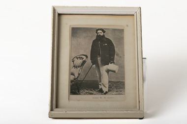
Photograph, JUDGE W. H. GAUNT
This photograph is a copy displayed in the Australian Dictionary of Biography. The original photograph is in the La Trobe Collection in the State Library of Victoria. William Henry Gaunt (1830-1905), judge, was born on 27 July 1830 at Leek, Staffordshire, England, son of John Gaunt, banker, and his wife Mary, née Bakewell. Educated at Leek Grammar School and Whitchurch, Salop, he migrated to Melbourne, and entered the Victorian public service and was rapidly promoted. By March 1854 he was chief clerk at Beechworth, the administrative centre of the Ovens goldfield. In July 1855 the resident warden commended Gaunt as 'a highly valuable public servant' with an intimate knowledge of the district and the 'temper and disposition of the miners'. Appointed sub-warden in the Beechworth district in January 1856 and a Chinese protector in August, he was given control of the extensive Woolshed district. When European miners attacked a party of Chinese at the Buckland River diggings in May 1857 Gaunt was sent to restore order. One of his proclamations, issued in Chinese characters, concluded 'W. H. Gaunt, your protector—tremble and obey!' In June he was appointed a police magistrate and next month was sent to take charge at the Buckland where the Chinese had been expelled from the diggings; the police force assisting him was led by Robert O'Hara Burke. In January 1858 Gaunt was appointed a warden, in November was transferred to Chiltern, north of Beechworth, and in August 1859 was made a commissioner of crown lands. In February 1860 Gaunt was appointed a coroner of Victoria, acting at Indigo, near Chiltern. In April 1865 he was transferred to Beechworth, became visiting justice of the gaol and later moved to Sandhurst. In January 1869 he was appointed returning officer for the mining district of Ballarat and visiting justice of the gaol. He was associated with this area for the rest of his life and won high repute for his integrity. In 1874 he chaired the inaugural meeting of the first Australian competitive swimming club. For years he studied law and was called to the Bar in December 1873. He was one of the many public servants dismissed by Graham Berry on 9 January 1878 (Black Wednesday). After petitioning the Queen in vain over his dismissal he began practice in Ballarat as a barrister. He soon became a leading authority on mining laws; one of the cases in which he was involved was the lengthy inquest on the bodies of the twenty-two miners drowned in the New Australasian mine disaster at Creswick in 1882. He was appointed a temporary judge of the Insolvency Court in 1889 and a County Court judge in 1891. In 1900 he was chairman of the royal commission which considered Metropolitan Board of Works matters, and in 1902 was president of the inquiry into the unification of municipalities in Victoria. In 1860 Gaunt married Elizabeth Mary, the youngest daughter of Frederick Palmer; they had nine children. Of the surviving five sons and two daughters, Ernest Frederick Augustus and Guy Reginald Archer both became admirals and were knighted; Cecil Robert became a lieutenant-colonel, Clive Herbert a government advocate in Rangoon and Mary (Mrs H. L. Miller) one of the first women students to enrol at the University of Melbourne (1881), although she did not complete her degree; she became a successful novelist. Gaunt died on 5 October 1905. An anonymous colleague said: 'I don't think he was ever excelled as a police magistrate, and during the many years he was on the County Court bench he earned the highest regard. His capacities were as unquestioned as his integrity, and more could not be said of any judge'. Select Bibliography Votes and Proceedings (Legislative Assembly, Victoria), 1878, 3, (58) Government Gazette (Victoria), 22 Feb, 15 Aug 1856, 30 June 1857, 5 Jan 1858, 16 Aug 1859, 3 Feb 1860, 7 Mar, 11 Oct 1862, 28 Mar, 4 Apr 1865, 17 May 1867, 9 June 1868, 22, 29 Jan 1869 Ovens and Murray Advertiser, 21 May 1857, 11 Mar 1865 Colonial Secretary's in-letters, goldfields, 25 Mar 1854, 21 July, 18 Nov 1855, 22 Aug 1857 (Public Record Office Victoria) scrapbook and newsclippings (privately held). Related Entries in NCB Sitesview family tree Gaunt, Mary Eliza (daughter)go to ADB entryPhotograph of Judge W. H. Gaunt standing beside chair holding top hat and cane, under glass, in cream frame with cream matte.Printed name underneath: JUDGE W. H. GAUNT -
 Flagstaff Hill Maritime Museum and Village
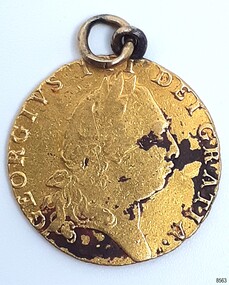
Currency - Guinea Coin, The Royal Mint, 1793 George III Spade Guinea, 1793
The coin was discovered by Julie Wilkins, a Victorian scuba diver who had already experienced more than 500 dives in Australia and overseas. She was holidaying in Peterborough, Victoria, and looking forward to discovering more about the famous Loch Ard ship, wrecked in June 1878 at Mutton Bird Island. The fast Glasgow-built clipper ship was only five years old when the tragedy occurred. There were 54 people on board the vessel and only two survived Julie's holiday photograph of Boat Bay reminds her of her most memorable dive. Submerged in the calm, flat sea, she was carefully scanning around the remains of the old wreck when, to her amazement, a gold coin and a small gold cross suddenly came up towards her. She excitedly cupped them in her hands, then stowed the treasures safely in her wetsuit and continued her dive. She soon discovered a group of brass carriage clock parts and some bottles of champagne. It was a day full of surprises. The items were easily recognisable, without any build-up of encrustations or concretion. Julie secretly enjoyed her treasures for twenty-four years then packed them up for the early morning train trip to Warrnambool. After a short walk to Flagstaff Hill Maritime Museum and Village, her photograph was taken as she handed over her precious find. She told her story to a local newspaper reporter, lunched a café in town then took the late afternoon train home. Her generous donation is now part of a vast collection of Loch Ard shipwreck artefacts, including the gold watch and the Minton Majolica model peacock. The coin is a British 1793 George III Gold Spade Guinea. It was already 83 years old when the Loch Ard had set sail. The loop and ring have been added, perhaps as a pendant, pocket watch accessory or similar purpose. It may have been worn for ‘good luck’ on the long journey to Australia, where ships had to carefully navigate the treacherous Bass’s Strait before arriving at their destination of Melbourne. Sadly, many met their fate on that short stretch of ocean aptly named the Shipwreck Coast. The coin is very recognisable even though it was exposed to the wrecking of the ship, its consequent movement, and the sea's turbulence. Its bent, scratched, buckled, split, dinted and worn condition is part of its story. The red-brown-black discolouration is similar to that found on other gold coins, sometimes called the ‘corrosion phenomena’. Studies suggest the possible cause is contaminants in the minting process reacting to the coins’ environment. The GEORGE III GOLD SPADE GUINEA: - The British Guinea was introduced in 1663 and was circulated until 1814. It was made of 22 carat gold, was 25 to 26 cm in diameter and weighed 8.35 grams. It had a value of 21 British shillings. The guinea coin ceased circulation after 1816 and was replaced by the one-pound note. However, the term ‘guinea’ continued to represent 21 shillings. King George (1738-1820) had six gold guinea designs minted during his reign from 1760 and 1820. Each of the six had different obverse portraits, all facing the right. There were three different reverse sides. The Spade Guinea was the fifth issue of the coin, introduced in 1787 and produced until 1799. The reverse shows a royal crown over a flat-topped shield with the Royal Arms of Great Britain, used in Scotland between 1714 and 1800. The shield images are, from left to right, top to bottom, the Arms of England and Scotland, the Arms of France, the Arms of Ireland, and the Arms of the House of Hanover. The Gold Guinea is also part of Australia’s history. It was the first coin mentioned in the announcement of Governor King of New South Wales his Australian Proclamation of a limited variety and denomination of coins accepted for use in the Australian Colony. The historic and decorative George III Spade Guinea has been reproduced for special collections of coins. However, replicas and imitations have also been made as souvenirs for tourists, as gaming tokens and chips for gamblers, and as ‘fake’ coins for profit. These coins differ in many ways; they may be only half the weight of the genuine coin. Often have a small stamp on the obverse with “COPY” or the manufacturer’s name or initials. Some have scalloped edges, some have dates that are different to the original dates of issue, and some even have text in Latin that translates as something very different to the original coin.The King George III Guinea was only produced from 1663 to 1814 and was the first English coin to be mechanically minted. The coin is the fifth edition of the King George III Guinea, the Spade Guinea, was only produced between 1787 and 1799. It is the only edition with this portrait of King George and the only one with the Royal Coat of Arms of Great Britain in Scotland on the reverse side. This edition was also the last guinea in circulation, because the sixth edition was reserved as the Military guinea. This edition of the Guinea is unique; This coin is the only guinea in our collection. It was minted in 1793, so it is now over 230 years old. The Gold Guinea is part of Australia’s history; it was the first coin in the list of coins for use in the Australian Colonies, mentioned by Governor King of New South Wales in his Australian Proclamation speech of 1800. The George III Spade Guinea was included in the Limited Edition Sherwood 12 Coin Collection of Notable Coinage of Australia. This coin is the only known guinea coin recovered from the wreck of the Loch Ard. It was already 85 years old when the ship was wrecked.Gold coin; British. 1793, King George III of the United Kingdom of Great Britain and Ireland (1760-1820), Spade Guinea. Yellow gold coin with gold metal loop mount and a gold ring through the loop. The design is the fifth issue of the George III Gold Guinea. The obverse relief is a portrait of George III facing right. Reverse relief is a crown above the Coats of Arms (1801-1816) of flat top spade-shaped shield divided into four quadrants that depict crowned lions, fleur de lies, a harp. These images are identified as, from left to right, top to bottom, England and Scotland, France, Ireland and Hanover. Inscriptions are minted around the rims of each side. The coin is dated 1793. Its surface has dark areas on both sides and the reed edge and surfaces are well worn. The loop mount is bent and the ring is buckled. The coin was recovered from the wreck of the ship Loch Ard.Obverse text; 'GEORGIVS III DEI GRATIA' (translates to George the Third, by the Grace of God) Obverse relief; (King George III bust, facing right, laurel wreath on head) Reverse text; 'M.B.E.ET.H.REX.F. D.B.ET.L.D. S.R.I.A.T.ET.E' '1793' (translates to: King of Great Britain, France and Ireland, Defender of the Faith, Duke of Brunswick and Lüneburg, Arch-Treasurer and Elector of the Holy Roman Empire) Reverse relief; a spade-shaped image i.e. (Crown with fleer de lies, above Shield with crowned lions in different postures, a harp, and other details)flagstaff hill maritime museum and village, warrnambool, great ocean road, shipwreck coast, royal mint, british coin, currency, guinea, military guinea, australian currency, british guinea, gold coin, spade guinea, king george iii, george iii, fifth portrait, arms of england and scotland, arms of france, arms of ireland, arms of the house of hanover, coins, gold coins, gold medallion, georgian era, 1793, numismatics, contamination phenomena, gold corrosion, good luck, lucky charm, pendant, lucky coin, trade, loch ard, wreck of the loch ard, 1878, mutton bird island, peterborough, scuba diver, 1980s, guinea coin, gold guinea, shipwreck artefact, relic, julie wilkins