Showing 420 items
matching r. wells
-
 Federation University Historical Collection
Photograph - Little Gem tintype, Portrait of a Woman in a hat
The tintype (or ferrotype or Melainotype) was produced on metallic sheet (not, actually, tin) instead of glass. The plate was coated with collodion and sensitized just before use. It was introduced by Adolphe Alexandre Martin in 1853. The most common size was about the same as the carte-de-visite, 5.5cm x 9.0cm, but both larger and smaller ferrotypes were made. The smallest were "Little Gem" tintypes, about the size of a postage-stamp, made simultaneously on a single plate in a camera with 12 or 16 lenses. They were often produced by travelling photographers, and were cheaper than Ambrotypes so made photography available to working classes, not just to the more well-to-do. The print would come out laterally reversed (as one sees oneself in a mirror). Being quite rugged, tintypes could be sent by post. Tintypes were eventually superseded by gelatin emulsion dry plates in the 1880s, though street photographers in various parts of the world continued with this process until the 1950s. (Above information abridged from http://www.rleggat.com/photohistory/history/tintype.htm) The firm of Gove and Allen opened in Sydney in 1880 and were responsible for the belated popularizing of the gem tintype in Australia. The firm traded as both The American Gem Studio and The American Studio. Others franchises were opened in Melbourne, Ballarat and Sandhurst (Bendigo). The Sandhurst branch closed in 1882 and Adelaide in 1884. All Gove and Allen studios had ceased trading by 1885. The studio addresses were: 23 King William St, Adelaide; 324 George St, Sydney; 95 Swanston St, Melbourne; Howard Place, Sandhurst; 7 Queen St, Brisbane; The card mounts used in Gove and Allen studios in Australia are identical to those used in America. They were initially made of plain white card with embossing around the oval image opening in the mount while some also had simple geometric and floral printed designs as well. Although Gove and Allen studios produced the majority of gem tintypes in Australia, other studios offered them including: - London, American & Sydney Photo Company, 328 George St, Sydney; - David Edelsten, 55 & 57 Bourke St, Melbourne; - Burman's Portrait Rooms, St. George's Hall, 209 Bourke St, Melbourne; - Bell's Gem Portrait Studio, 57 Bourke St East, Melbourne; - R. H. Kenny, Bridge St, 6 Sturt St Ballarat; - Marinus W. Bent, Sandhurst (Bendigo); - George Fisher, Victoria; - Anson Brothers, Hobart Town. (Abridged information from http://members.ozemail.com.au/~msafier/photos/tintypes.html) .9) A tintype portrait of a woman's head, attached to a card. The cheeks have been hand coloured.little gem, woman, unidentified woman, women, photography -
 Federation University Historical Collection
Photograph - Little Gem tintype, Possibly American Studio, Portrait of a Boy
The tintype (or ferrotype or Melainotype) was produced on metallic sheet (not, actually, tin) instead of glass. The plate was coated with collodion and sensitized just before use. It was introduced by Adolphe Alexandre Martin in 1853. The most common size was about the same as the carte-de-visite, 5.5cm x 9.0cm, but both larger and smaller ferrotypes were made. The smallest were "Little Gem" tintypes, about the size of a postage-stamp, made simultaneously on a single plate in a camera with 12 or 16 lenses. They were often produced by travelling photographers, and were cheaper than Ambrotypes so made photography available to working classes, not just to the more well-to-do. The print would come out laterally reversed (as one sees oneself in a mirror). Being quite rugged, tintypes could be sent by post. Tintypes were eventually superseded by gelatin emulsion dry plates in the 1880s, though street photographers in various parts of the world continued with this process until the 1950s. (Above information abridged from http://www.rleggat.com/photohistory/history/tintype.htm) The firm of Gove and Allen opened in Sydney in 1880 and were responsible for the belated popularizing of the gem tintype in Australia. The firm traded as both The American Gem Studio and The American Studio. Others franchises were opened in Melbourne, Ballarat and Sandhurst (Bendigo). The Sandhurst branch closed in 1882 and Adelaide in 1884. All Gove and Allen studios had ceased trading by 1885. The studio addresses were: 23 King William St, Adelaide; 324 George St, Sydney; 95 Swanston St, Melbourne; Howard Place, Sandhurst; 7 Queen St, Brisbane; The card mounts used in Gove and Allen studios in Australia are identical to those used in America. They were initially made of plain white card with embossing around the oval image opening in the mount while some also had simple geometric and floral printed designs as well. Although Gove and Allen studios produced the majority of gem tintypes in Australia, other studios offered them including: - London, American & Sydney Photo Company, 328 George St, Sydney; - David Edelsten, 55 & 57 Bourke St, Melbourne; - Burman's Portrait Rooms, St. George's Hall, 209 Bourke St, Melbourne; - Bell's Gem Portrait Studio, 57 Bourke St East, Melbourne; - R. H. Kenny, Bridge St, 6 Sturt St Ballarat; - Marinus W. Bent, Sandhurst (Bendigo); - George Fisher, Victoria; - Anson Brothers, Hobart Town. (Abridged information from http://members.ozemail.com.au/~msafier/photos/tintypes.html) .9) A tintype portrait of a child's head and torso, attached to a card. The boy is wearing a suit and the cheeks have been hand coloured.little gem -
 Federation University Historical Collection
Photograph - Little Gem tintype, Portrait of a Woman in a Hat
The tintype (or ferrotype or Melainotype) was produced on metallic sheet (not, actually, tin) instead of glass. The plate was coated with collodion and sensitized just before use. It was introduced by Adolphe Alexandre Martin in 1853. The most common size was about the same as the carte-de-visite, 5.5cm x 9.0cm, but both larger and smaller ferrotypes were made. The smallest were "Little Gem" tintypes, about the size of a postage-stamp, made simultaneously on a single plate in a camera with 12 or 16 lenses. They were often produced by travelling photographers, and were cheaper than Ambrotypes so made photography available to working classes, not just to the more well-to-do. The print would come out laterally reversed (as one sees oneself in a mirror). Being quite rugged, tintypes could be sent by post. Tintypes were eventually superseded by gelatin emulsion dry plates in the 1880s, though street photographers in various parts of the world continued with this process until the 1950s. (Above information abridged from http://www.rleggat.com/photohistory/history/tintype.htm) The firm of Gove and Allen opened in Sydney in 1880 and were responsible for the belated popularizing of the gem tintype in Australia. The firm traded as both The American Gem Studio and The American Studio. Others franchises were opened in Melbourne, Ballarat and Sandhurst (Bendigo). The Sandhurst branch closed in 1882 and Adelaide in 1884. All Gove and Allen studios had ceased trading by 1885. The studio addresses were: 23 King William St, Adelaide; 324 George St, Sydney; 95 Swanston St, Melbourne; Howard Place, Sandhurst; 7 Queen St, Brisbane; The card mounts used in Gove and Allen studios in Australia are identical to those used in America. They were initially made of plain white card with embossing around the oval image opening in the mount while some also had simple geometric and floral printed designs as well. Although Gove and Allen studios produced the majority of gem tintypes in Australia, other studios offered them including: - London, American & Sydney Photo Company, 328 George St, Sydney; - David Edelsten, 55 & 57 Bourke St, Melbourne; - Burman's Portrait Rooms, St. George's Hall, 209 Bourke St, Melbourne; - Bell's Gem Portrait Studio, 57 Bourke St East, Melbourne; - R. H. Kenny, Bridge St, 6 Sturt St Ballarat; - Marinus W. Bent, Sandhurst (Bendigo); - George Fisher, Victoria; - Anson Brothers, Hobart Town. (Abridged information from http://members.ozemail.com.au/~msafier/photos/tintypes.html) A tintype portrait of a woman's head and shoulders, attached to a card. The cheeks have been hand coloured.little gem, woman, unidentified woman, women, photography -
 Federation University Historical Collection
Photograph, Visit of the Chinese Commissioner to the Ballarat School of Mines, 13 November 1906, 23/11/1906 (exact)
The Chinese Imperial Commissioner, Hwang How Cheng, visited Australia at the request of the Chinese Emperor for the purpose of establishing Chinese consulates in the Commonwealth. He visited Ballarat at the request of Ballarat’s Chinese community. The newspaper reported that it was hoped the Commissioner would visit the Ballarat School of Mines “where the knowledge he would get would probably be of the utmost usefulness in the development of the great resources of China.” The Commissioner was accompanied by interpreter Ah Ket (Melbourne barrister and solicitor), and met by members of Ballarat’s Chinese community, including Dr Wong Chock Son. Apparently the Chinese Commissioner wanted to visit SMB because of its international fame relating to education in mining. From the SMB Letter book (Cat. No. 436) comes the following which suggests the Commissioner was based in Adelaide) '17th November 1906 His Excellency, Hwang How Cheng Chinese Commission Adelaide May it please your Excellency By this post I have the pleasure in forwarding for your Excellency's kind acceptance (and one for Mr. When) copies of the photograph taken of your recent visit to the School of Mines. I trust they will serve a pleasing memento of what, I hope, was a pleasant visit to our Golden City. Yours Faithfully Fredk Martell Director' The visit was reported in the Ballarat Star in 14 November 1906:- The Chinese Imperial Commissioner, Hwang Hon Cheng, who recently arrived in Victoria on behalf of the Chinese Government, paid a visit to Ballarat last evening, and was entertained by his fellow countrymen at a dinner at the Bow Leong rooms, Main street. The commissioner, who came up by the express, was accompanied by his secretary and Mr Ah Ket, the well-known Chinese barrister, of Melbourne; but some disappointment was expressed by the fact that he did not wear his official robes, being attired in the more sombre European dress. Mr W. D. M’Kee presided at the dinner, on the invitation of the Bow Leong Society, and in addition to representative Chinese residents, three were also present the mayor of the city (Cr. J. J. Brokenshire), Crs. R. Pearse, G. Crocker (City), J. R. Elsworth, A. Mackenzie, J. A. M’Neil, A. Levy, G. Bunting, F. Penhalluriack (Town), Col. Williams, Mr. J. Gent, Messrs. F. J. Martell (director of the School of Mines), A. W. Hager (president of the Orphan Asylum), A. Kenny (superintendent), R. G. Fitzgerald (clerk of courts at Ballarat East), J. Trethowan, A. A. Buley, Serg Dalton, and others. Apologies were received from the mayor of the town Revs. J. West Lau, Dr Cairns, Hon. J. Y. M’Donald, L. Lederman, C. C. Shoppee and others. The gathering was a very cordial one, and the hospitality of the Chinese was greatly appreciated. After the loyal toasts, “The King” and “The Emperor of China,” had been honoured, the chairman extended a hearty welcome on behalf of the society and others to the commissioner. Mr M’Kee said he was privileged to speak in behalf of the Chinese. There was a warm feeling of friendship between them and himself, and his services were always at their command. If he were in China he would desire that a similar compliment would be extended to him. They were all pleased the Emperor of China had sent the commissioner to establish consulates in Australia with a view of the empire understanding the feelings of Australasia better than they did at present. He hoped the commissioner would have opportunity of visiting some of their industries, as they desired him to gain all the scientific and practical knowledge of those industries that he could. The toast of “The Commissioner” was proposed by Col. Williams who expressed pleasure at the visit of a gentleman of education and attainments to look into the condition of the scions of China in Australia. He hoped the commissioner would carry away a correct impression. In Australia they had nothing to conceal; they hoped to be understood. (Applause.) No intelligent man had the temerity to condescend to patronise China, one of the richest countries in the world, with a civilisation dating back thousands of years. In the matter of population alone it was equal to one-third of the world. They heard a lot about the “awakening of China.” They hoped it would be humane, just, and considerate if it had power. He hoped the commissioner would be satisfied with what he saw. The law of filial relation to the children was strictly observed in China, and he did not know whether it would not be a good thing if they had a little more of that religion here. It would be a fair thing to tell the commissioner that while he might inquire into the labour laws, the basis of these laws was not a desire to oppress but to enable every man to obtain the same conditions they expected from their own people. If he gained that impression he felt they would be fairly treated. (Applause.) Mayor Brokenshire supported the toast. They had, he said, in the Chinese a most law-abiding people. Their behaviour was an example to the British citizens. They were quiet, inoffensive men, and they toiled hard, even on Sundays. (Laughter.) Mr Ah Ket; That is what the government does with the railway employees. (Laughter.) The Commissioner replied through Mr Ah Ket, who in a graceful speech acknowledged the toast. The commissioner had, he said been delighted with what he had seen of the country – he believed it to be one of the finest in the world – and he greatly appreciated the hospitality extended to him. (Applause.) The Chairman proposed the toast of “The health of Mr Ah Ket,” and paid a tribute to his ability. It was satisfactory to see that he had risen to such a position, and it might be that in the future he would be asked to occupy a position on the bench. (Applause.) Mr Ah Ket, in response, said he had not come prepared to make a speech. He had come to Ballarat to have a quiet evening with his friends, and as soon as he arrived he had been whirled away in a motor car to a place where he found an aggregation of East and West. He was pleased to see them commingled at the festive board. That suggested the idea that East and West could meet together without friction. Misunderstandings arose only because men were superficial. If they threw off outer garments they would know each other better. He looked forward to the time when nations would understand each other. It was by an interchange of visits that such things could be accomplished, and nations would then live at peace with each other. (Applause.) Other toasts were also honored. Twelve men pose for a photograph on the stairs of a building at the Ballarat School of Mines. Back row left to right: A.D. Gilchrist (Prof. of Engineering), B. Whittington (Mathematics, Physics), Thomas S. Hart (Prof. of Geology and Mining), J.M. Sutherland (Electrical Engineering) Front row left to right: Dr Wong Chock Son (Ballarat), Fred. J. Martell, Alfred Mica Smith, Ah Ket esq (Melbourne Barrister), His Excellency Hwang How Cheng (Chinese Commissioner), Wen Esq (Secretary), Alderman Grase (mayor of Brisbane), Grase Esq (Ballarat).ballarat school of mines, alfred mica smith, fred martell, j m sutherland, a d gilchrist, b whittington, thomas hart, wong chock son, ah ket, hwang how cheng, chinese, chinese commissioner, international, new classrooms, administration building, a building -
 Federation University Historical Collection
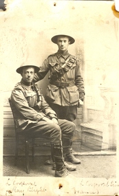
Postcard - Postcard - Black and white, Two World War One Soldiers, 1916, 28/08/1916
John Raymond (Ray) Blight enlisted on 19 July 1915. He was an electrical engineer, having studied at the Ballarat School of Mines. On 23 June 1916 Ray Blight disembarked at Marseilles. 3 February 1917 he was hospitalised with scabies. Ray Blight's next of kin was his mother, Mary Jane Blight of 116 Lyons Street South, Ballarat. James Leslie Sim enlisted on 13 July 1915, at which time he was an accountant. His next of kin was his father, Charles Robert Sim of Drummond Street North, Ballarat. On 23 June 1916 James Sim disembarked at Marseilles. A year later he received leave to the United Kingdom returning to France 2 weeks later. He received leave to Paris from 18 march 1918 to 4 April 1918. Sim was wounded on 1 June 1918.Two World War One soldiers in military uniform pose for a photograph. The two men are Lance Corporal Ray Blight and Lance Corporal Sim (both of Ballarat). On the back is a personal letter to Ballarat School of Mines Lecturer Daniel Walker. The pin holes in the postcard suggest it was displayed at the Ballarat School of Mines. .1) Verso: " France 25/8/16. Dear Mr Walker, Just a line in sending a photo we had taken in a small photographers, in a town within range of the evenings guns, the other boy is L/Corp Sim, one time an old SMB and son of R. Sim, of Ballarat, we are wearing steel helmuts weight about 4lbs they are protection against shrapnel and steel splinters. We are doing well here, Les Coulter was wounded just near here but did not see him. Best wishes to all. Ray Blight. .2) Verso: Sitting, Ray Blight, from Ballarat, you will know his sister, she helps Miss Brazena a lot with the parcels. Standing, Les Sim, of Sim and co. wood merchants, Ballarat.world war one, world war 1, james sim, ballarat school of mines, blight, james blight, sim, les sim, coulter, les coulter, world war, walker, wwi, great world war, france -
 Flagstaff Hill Maritime Museum and Village
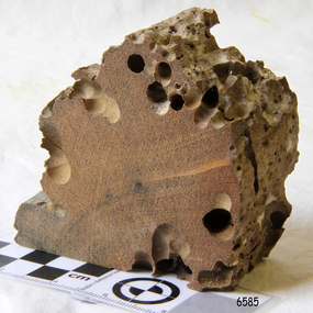
Wood Sample, about 1871
This piece of timber from the ship Eric the Red has been eaten through by the marine animals called Teredo Worms, sometimes called sea worms or ‘termites of the sea’. The worms bore holes into wood that is immersed in sea water and bacteria inside the worms digest the wood. Shipbuilders tried to prevent this problem by using coatings of tar, wax, lead or pitch. In the 18th and 19th centuries the outside of their ships were sheathed in copper or a combination of copper and zinc (called Muntz metal) and would be re-metalled periodically to ensure the sheathing would remain effective. In more recent times the ships are protected with a toxic coating. The American ship Eric the Red was a wooden, three masted clipper ship. She had 1,580 tons register and was the largest full-rigged ship built at Bath, Maine, USA in 1871. She was built and registered by Arthur Sewall, later to become the partnership E. & A. Sewall, the 51st ship built by this company. The annually-published List of Merchant Vessels of the U.S. shows Bath was still the home port of Eric the Red in 1880. The vessel was named after the Viking discoverer, Eric ‘the Red-haired’ Thorvaldsson , who was the first European to reach the shores of North America (in 980AD). The ship Eric the Red at first traded in coal between America and Britain, and later traded in guano nitrates from South America. In 1879 she was re-metalled and was in first class condition. On 10th June 1880 (some records say 12th June) Eric the Red departed New York for Melbourne and then Sydney. She had been commissioned by American trade representatives to carry a special cargo of 500 exhibits (1400 tons) – about a quarter to a third of America’s total exhibits - for the U.S.A. pavilion at Melbourne’s first International Exhibition. The exhibits included furniture, ironmongery, wines, chemicals, dental and surgical instruments, paper, cages, bronze lamp trimmings, axles, stamped ware, astronomical and time globes, samples of corn and the choicest of leaf tobacco. Other general cargo included merchandise such as cases of kerosene and turpentine, brooms, Bristol's Sarsaparilla, Wheeler and Wilson sewing machines, Wheeler’s thresher machine, axe handles and tools, cases of silver plate, toys, pianos and organs, carriages and Yankee notions. The Eric the Red left New York under the command of Captain Zaccheus Allen (or some records say Captain Jacques Allen) and 24 other crew including the owner’s son third mate Ned Sewall. There were also 2 saloon passengers on board. The ship had been sailing for an uneventful 85 days and the voyage was almost at its end. As Eric the Red approached Cape Otway there was a moderate north-west wind and hazy and overcast atmosphere. On 4th September 1880 at about 1:30am Captain Allen sighted the Cape Otway light and was keeping the ship 5-6 miles offshore to stay clear of the hazardous Otway Reef. However he had badly misjudged his position. The ship hit the Otway Reef about 2 miles out to sea, south west of the Cape Otway light station. Captain Allen ordered the wheel to be put ‘hard up’ thinking that she might float off the reef. The sea knocked the helmsman away from the wheel, broke the wheel ropes and carried away the rudder. The lifeboats were swamped, the mizzenmast fell, with all of its rigging, then the mainmast also fell and the ship broke in two. Some said that the passenger Vaughan, who was travelling for his health and not very strong, was washed overboard and never seen again. The ship started breaking up. The forward house came adrift with three of the crew on it as well as a longboat, which the men succeeded in launching and keeping afloat by continually bailing with their sea boots. The captain, the third mate (the owner’s son) and others clung to the mizzenmast in the sea. Then the owner’s son was washed away off the mast. Within 10 minutes the rest of the ship was in pieces, completely wrecked, with cargo and wreckage floating in the sea. The captain encouraged the second mate to swim with him to the deckhouse where there were other crew but the second mate wouldn’t go with him. Eventually the Captain made it to the deckhouse and the men pulled him up. At about 4:30am the group of men on the deckhouse saw the lights of a steamer and called for help. At the same time they noticed the second mate and the other man had drifted nearby, still on the spur, and pulled them both onto the wreck. The coastal steamer SS Dawn was returning to Warrnambool from Melbourne, its sailing time different to its usual schedule. She was built in 1876 and bought by the Portland and Belfast Steam Navigation Co. in 1877. At the time of this journey she was commanded by Captain Jones, and was sailing between Melbourne and Portland via Warrnambool. The provedore of the Dawn, Benjamin Lear, heard cries of distress coming through the portholes of the saloon. He gave the alarm and the engines were stopped. Cries could be heard clearly, coming from the land. Captain Jones sent out crew in two boats, and fired off rockets and blue lights to illuminate the area. They picked up the three survivors who were in the long boat from Eric the Red. Two men were picked up out of the water, one being the owner’s son who was clinging to floating kerosene boxes. At daylight the Dawn then rescued the 18 men from the floating portion of the deckhouse, which had drifted about 4 miles from where they’d struck the reef. Shortly after the rescue the deckhouse drifted onto breakers and was thrown onto rocks at Point Franklin, about 2 miles east of Cape Otway. Captain Jones had signalled to Cape Otway lighthouse the number of the Eric the Red and later signalled that there was a wreck at Otway Reef but there was no response from the lighthouse. The captain and crew of the Dawn spent several more hours searching unsuccessfully for more survivors, even going back as far as Apollo Bay. On board the Dawn the exhausted men received care and attention to their needs and wants, including much needed clothing. Captain Allen was amongst the 23 battered and injured men who were rescued and later taken to Warrnambool for care. Warrnambool’s mayor and town clerk offered them all hospitality, the three badly injured men going to the hospital for care and others to the Olive Branch Hotel, then on to Melbourne. Captain Allen’s leg injury prevented him from going ashore so he and three other men travelled on the Dawn to Portland. They were met by the mayor who also treated them all with great kindness. Captain Allen took the train back to Melbourne then returned to America. Those saved were Captain Zaccheus Allen (or Jacques Allen), J. Darcy chief mate, James F. Lawrence second mate, Ned Sewall third mate and owner’s son, John French the cook, C. Nelson sail maker, Clarence W. New passenger, and the able seamen Dickenson, J. Black, Denis White, C. Herbert, C. Thompson, A. Brooks, D. Wilson, J. Ellis, Q. Thompson, C. Newman, W. Paul, J. Davis, M. Horenleng, J. Ogduff, T. W. Drew, R. Richardson. Four men had lost their lives; three of them were crew (Gus Dahlgreen ship’s carpenter, H. Ackman steward, who drowned in his cabin, and George Silver seaman) and one a passenger (J. B. Vaughan). The body of one of them had been found washed up at Cape Otway and was later buried in the lighthouse cemetery; another body was seen on an inaccessible ledge. Twelve months later the second mate James F. Lawrence, from Nova Scotia, passed away in the Warrnambool district; an obituary was displayed in the local paper. Neither the ship, nor its cargo, was insured. The ship was worth about £15,000 and the cargo was reportedly worth £40,000; only about £2,000 worth had been recovered. Cargo and wreckage washed up at Apollo Bay, Peterborough, Port Campbell, Western Port and according to some reports, even as far away as the beaches of New Zealand. The day after the wreck the government steam ship Pharos was sent from Queenscliff to clear the shipping lanes of debris that could be a danger to ships. The large midship deckhouse of the ship was found floating in a calm sea near Henty Reef. Items such as an American chair, a ladder and a nest of boxes were all on top of the deckhouse. As it was so large and could cause danger to passing ships, Captain Payne had the deckhouse towed towards the shore just beyond Apollo Bay. Between Apollo Bay and Blanket Bay the captain and crew of Pharos collected Wheeler and Wilson sewing machines, nests of boxes, bottles of Bristol’s sarsaparilla, pieces of common American chairs, axe handles, a Wheelers’ Patent thresher and a sailor’s trunk with the words “A. James” on the front. A ship’s flag-board bearing the words “Eric the Red” was found on the deckhouse; finally those on board the Pharos had the name of the wrecked vessel. During this operation Pharos came across the government steamer Victoria and also a steamer S.S. Otway, both of which were picking up flotsam and wreckage. A whole side of the hull and three large pieces of the other side of the hull, with some of the copper sheathing stripped off, had floated on to Point Franklin. Some of the vessels yards and portions of her masts were on shore. The pieces of canvas attached to the yards and masts confirmed that the vessel had been under sail. The beach there was piled with debris several feet high. There were many cases of Diamond Oil kerosene, labelled R. W. Cameron and Company, New York. There were also many large planks of red pine, portions of a small white boat and a large, well-used oar. Other items found ashore included sewing machines (some consigned to ‘Long and Co.”) and notions, axe and scythe handles, hay forks, wooden pegs, rolls of wire (some branded “T.S” and Co, Melbourne”), kegs of nails branded “A.T. and Co.” from the factory of A. Field and Son, Taunton, Massachusetts, croquet balls and mallets, buggy fittings, rat traps, perfumery, cutlery and Douay Bibles, clocks, bicycles, chairs, a fly wheel, a cooking stove, timber, boxes, pianos, organs and a ladder. (Wooden clothes pegs drifted in for many years). There seemed to be no personal luggage or clothing. The Pharos encountered a long line, about one and a half miles, of floating wreckage about 10 miles off land, south east of Cape Otway, and in some places about 40 feet wide. It seemed that more than half of it was from Eric the Red. The ship’s crew rescued 3 cases that were for the Melbourne Exhibition and other items from amongst the debris. There were also chairs, doors, musical instruments, washing boards, nests of trunks and fly catchers floating in the sea. Most of the goods were saturated and smelt of kerosene. A section of the hull lies buried in the sand at Parker River Beach. An anchor with chain is embedded in the rocks east of Point Franklin and a second anchor, thought to be from Eric the Red, is on display at the Cape Otway light station. (There is a photograph of a life belt on the verandah of Rivernook Guest House in Princetown with the words “ERIC THE RED / BOSTON”. This is rather a mystery as the ship was registered in Bath, Maine, USA.) Parts of the ship are on display at Bimbi Park Caravan Park and at Apollo Bay Museum. Flagstaff Hill Maritime Village also has part of the helm (steering wheel), a carved wooden sword (said to be the only remaining portion of the ship’s figurehead; further research is currently being carried out), a door, a metal rod, several samples of wood and a medal for bravery, awarded to Nelson Johnson, a crew member of the S.S. Dawn by the U.S. President, for the rescue of the crew. Much of the wreckage was recovered by the local residents before police and other authorities arrived at the scene. Looters went to great effort to salvage goods, being lowered down the high cliff faces to areas with little or no beach to collect items from the wreckage, their mates above watching out for dangerous waves. A Tasmanian newspaper reports on a court case in Stawell, Victoria, noting a man who was caught 2 months later selling tobacco from the wreckage of Eric the Red. Some of the silverware is still treasured by descendants of Mr Mackenzie who was given these items by officials for his help in securing the cargo. The gifts included silver coffee and tea pots, half a dozen silver serviette rings and two sewing machines. A Mr G.W. Black has in his possession a medal and a purse that were awarded to his father, another Dawn crew member who was part of the rescue team. The medal is inscribed and named “To John Black ….” (from “Shipwrecks” by Margaret E. Mackenzie, 3rd edition, published 1964). The wreck and cargo were sold to a Melbourne man who salvaged a quantity of high quality tobacco and dental and surgical instruments. Timbers from the ship were salvaged and used in the construction of houses and sheds around Apollo Bay, including a guest house, Milford House (since burnt down in bushfires), which had furniture, fittings and timber on the dining room floor from the ship. A 39.7 foot long trading ketch, the Apollo, was also built from its timbers by Mr Burgess in 1883 and subsequently used in Tasmanian waters. It was the first attempt at ship building in Apollo bay. In 1881 a red light was installed about 300 feet above sea level at the base of the Cape Otway lighthouse to warn ships when they were too close to shore; It would not be visible unless a ship came within 3 miles from it. This has proved to be an effective warning. Nelson Johnson, recipient of the medal for bravery, married Elizabeth Howard in 1881 and they had 10 children. They lived in South Melbourne, Victoria. Nelson died in 1922 in Fitzroy Victoria, age 66. In 1895 the owners of the S.S. Dawn, the Portland and Belfast Steam Navigation Co., wound up and sold out to the Belfast Company who took over the Dawn for one year before selling her to Howard Smith. She was condemned and sunk in Suva in 1928. The State Library of Victoria has a lithograph in its collection depicting the steamer Dawn and the shipwrecked men, titled. "Wreck of the ship Eric the Red, Cape Otway: rescue of the crew by the Dawn".The wood (timber) sample is listed on the Collections Australia Database, Heritage Victoria, number 239 00010 A “The Eric the Red is historically significant as one of Victoria's major 19th century shipwrecks. (Heritage Victoria Eric the Red; HV ID 239) The wreck led to the provision of an additional warning light placed below the Cape Otway lighthouse to alert mariners to the location of Otway Reef. The site is archaeologically significant for its remains of a large and varied cargo and ship's fittings being scattered over a wide area. The site is recreationally and aesthetically significant as it is one of the few sites along this coast where tourists can visit identifiable remains of a large wooden shipwreck, and for its location set against the background of Cape Otway, Bass Strait, and the Cape Otway lighthouse.“ (Victorian Heritage Database Registration Number S239, Official Number 8745 USA) Wood sample from the wreck of the ship Eric the Red. Triangular shaped, full of sea worm (Teredo worm) holes. The wood is dark in colour and is very light in weight.flagstaff hill, warrnambool, shipwrecked-coast, flagstaff-hill, flagstaff-hill-maritime-museum, maritime-museum, shipwreck-coast, flagstaff-hill-maritime-village, shipwreck-artefact, eric-the-red, zaccheus-allen, sewall, 1880, melbourne-exhibition, cape-otway, otway-reef, wood-sample, s.s.-dawn -
 Flagstaff Hill Maritime Museum and Village
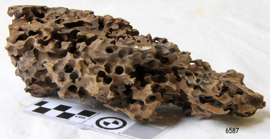
Wood Sample, About 1871
This piece of timber from the ship Eric the Red has been eaten through by the marine animals called Teredo Worms, sometimes called sea worms or ‘termites of the sea’. The worms bore holes into wood that is immersed in sea water and bacteria inside the worms digest the wood. Shipbuilders tried to prevent this problem by using coatings of tar, wax, lead or pitch. In the 18th and 19th centuries the outside of their ships were sheathed in copper or a combination of copper and zinc (called Muntz metal) and would be re-metalled periodically to ensure the sheathing would remain effective. In more recent times the ships are protected with a toxic coating. The American ship Eric the Red was a wooden, three masted clipper ship. She had 1,580 tons register and was the largest full-rigged ship built at Bath, Maine, USA in 1871. She was built and registered by Arthur Sewall, later to become the partnership E. & A. Sewall, the 51st ship built by this company. The annually-published List of Merchant Vessels of the U.S. shows Bath was still the home port of Eric the Red in 1880. The vessel was named after the Viking discoverer, Eric ‘the Red-haired’ Thorvaldsson , who was the first European to reach the shores of North America (in 980AD). The ship Eric the Red at first traded in coal between America and Britain, and later traded in guano nitrates from South America. In 1879 she was re-metalled and was in first class condition. On 10th June 1880 (some records say 12th June) Eric the Red departed New York for Melbourne and then Sydney. She had been commissioned by American trade representatives to carry a special cargo of 500 exhibits (1400 tons) – about a quarter to a third of America’s total exhibits - for the U.S.A. pavilion at Melbourne’s first International Exhibition. The exhibits included furniture, ironmongery, wines, chemicals, dental and surgical instruments, paper, cages, bronze lamp trimmings, axles, stamped ware, astronomical and time globes, samples of corn and the choicest of leaf tobacco. Other general cargo included merchandise such as cases of kerosene and turpentine, brooms, Bristol's Sarsaparilla, Wheeler and Wilson sewing machines, Wheeler’s thresher machine, axe handles and tools, cases of silver plate, toys, pianos and organs, carriages and Yankee notions. The Eric the Red left New York under the command of Captain Zaccheus Allen (or some records say Captain Jacques Allen) and 24 other crew including the owner’s son third mate Ned Sewall. There were also 2 saloon passengers on board. The ship had been sailing for an uneventful 85 days and the voyage was almost at its end. As Eric the Red approached Cape Otway there was a moderate north-west wind and hazy and overcast atmosphere. On 4th September 1880 at about 1:30am Captain Allen sighted the Cape Otway light and was keeping the ship 5-6 miles offshore to stay clear of the hazardous Otway Reef. However he had badly misjudged his position. The ship hit the Otway Reef about 2 miles out to sea, south west of the Cape Otway light station. Captain Allen ordered the wheel to be put ‘hard up’ thinking that she might float off the reef. The sea knocked the helmsman away from the wheel, broke the wheel ropes and carried away the rudder. The lifeboats were swamped, the mizzenmast fell, with all of its rigging, then the mainmast also fell and the ship broke in two. Some said that the passenger Vaughan, who was travelling for his health and not very strong, was washed overboard and never seen again. The ship started breaking up. The forward house came adrift with three of the crew on it as well as a longboat, which the men succeeded in launching and keeping afloat by continually bailing with their sea boots. The captain, the third mate (the owner’s son) and others clung to the mizzenmast in the sea. Then the owner’s son was washed away off the mast. Within 10 minutes the rest of the ship was in pieces, completely wrecked, with cargo and wreckage floating in the sea. The captain encouraged the second mate to swim with him to the deckhouse where there were other crew but the second mate wouldn’t go with him. Eventually the Captain made it to the deckhouse and the men pulled him up. At about 4:30am the group of men on the deckhouse saw the lights of a steamer and called for help. At the same time they noticed the second mate and the other man had drifted nearby, still on the spur, and pulled them both onto the wreck. The coastal steamer SS Dawn was returning to Warrnambool from Melbourne, its sailing time different to its usual schedule. She was built in 1876 and bought by the Portland and Belfast Steam Navigation Co. in 1877. At the time of this journey she was commanded by Captain Jones, and was sailing between Melbourne and Portland via Warrnambool. The provedore of the Dawn, Benjamin Lear, heard cries of distress coming through the portholes of the saloon. He gave the alarm and the engines were stopped. Cries could be heard clearly, coming from the land. Captain Jones sent out crew in two boats, and fired off rockets and blue lights to illuminate the area. They picked up the three survivors who were in the long boat from Eric the Red. Two men were picked up out of the water, one being the owner’s son who was clinging to floating kerosene boxes. At daylight the Dawn then rescued the 18 men from the floating portion of the deckhouse, which had drifted about 4 miles from where they’d struck the reef. Shortly after the rescue the deckhouse drifted onto breakers and was thrown onto rocks at Point Franklin, about 2 miles east of Cape Otway. Captain Jones had signalled to Cape Otway lighthouse the number of the Eric the Red and later signalled that there was a wreck at Otway Reef but there was no response from the lighthouse. The captain and crew of the Dawn spent several more hours searching unsuccessfully for more survivors, even going back as far as Apollo Bay. On board the Dawn the exhausted men received care and attention to their needs and wants, including much needed clothing. Captain Allen was amongst the 23 battered and injured men who were rescued and later taken to Warrnambool for care. Warrnambool’s mayor and town clerk offered them all hospitality, the three badly injured men going to the hospital for care and others to the Olive Branch Hotel, then on to Melbourne. Captain Allen’s leg injury prevented him from going ashore so he and three other men travelled on the Dawn to Portland. They were met by the mayor who also treated them all with great kindness. Captain Allen took the train back to Melbourne then returned to America. Those saved were Captain Zaccheus Allen (or Jacques Allen), J. Darcy chief mate, James F. Lawrence second mate, Ned Sewall third mate and owner’s son, John French the cook, C. Nelson sail maker, Clarence W. New passenger, and the able seamen Dickenson, J. Black, Denis White, C. Herbert, C. Thompson, A. Brooks, D. Wilson, J. Ellis, Q. Thompson, C. Newman, W. Paul, J. Davis, M. Horenleng, J. Ogduff, T. W. Drew, R. Richardson. Four men had lost their lives; three of them were crew (Gus Dahlgreen ship’s carpenter, H. Ackman steward, who drowned in his cabin, and George Silver seaman) and one a passenger (J. B. Vaughan). The body of one of them had been found washed up at Cape Otway and was later buried in the lighthouse cemetery; another body was seen on an inaccessible ledge. Twelve months later the second mate James F. Lawrence, from Nova Scotia, passed away in the Warrnambool district; an obituary was displayed in the local paper. Neither the ship, nor its cargo, was insured. The ship was worth about £15,000 and the cargo was reportedly worth £40,000; only about £2,000 worth had been recovered. Cargo and wreckage washed up at Apollo Bay, Peterborough, Port Campbell, Western Port and according to some reports, even as far away as the beaches of New Zealand. The day after the wreck the government steam ship Pharos was sent from Queenscliff to clear the shipping lanes of debris that could be a danger to ships. The large midship deckhouse of the ship was found floating in a calm sea near Henty Reef. Items such as an American chair, a ladder and a nest of boxes were all on top of the deckhouse. As it was so large and could cause danger to passing ships, Captain Payne had the deckhouse towed towards the shore just beyond Apollo Bay. Between Apollo Bay and Blanket Bay the captain and crew of Pharos collected Wheeler and Wilson sewing machines, nests of boxes, bottles of Bristol’s sarsaparilla, pieces of common American chairs, axe handles, a Wheelers’ Patent thresher and a sailor’s trunk with the words “A. James” on the front. A ship’s flag-board bearing the words “Eric the Red” was found on the deckhouse; finally those on board the Pharos had the name of the wrecked vessel. During this operation Pharos came across the government steamer Victoria and also a steamer S.S. Otway, both of which were picking up flotsam and wreckage. A whole side of the hull and three large pieces of the other side of the hull, with some of the copper sheathing stripped off, had floated on to Point Franklin. Some of the vessels yards and portions of her masts were on shore. The pieces of canvas attached to the yards and masts confirmed that the vessel had been under sail. The beach there was piled with debris several feet high. There were many cases of Diamond Oil kerosene, labelled R. W. Cameron and Company, New York. There were also many large planks of red pine, portions of a small white boat and a large, well-used oar. Other items found ashore included sewing machines (some consigned to ‘Long and Co.”) and notions, axe and scythe handles, hay forks, wooden pegs, rolls of wire (some branded “T.S” and Co, Melbourne”), kegs of nails branded “A.T. and Co.” from the factory of A. Field and Son, Taunton, Massachusetts, croquet balls and mallets, buggy fittings, rat traps, perfumery, cutlery and Douay Bibles, clocks, bicycles, chairs, a fly wheel, a cooking stove, timber, boxes, pianos, organs and a ladder. (Wooden clothes pegs drifted in for many years). There seemed to be no personal luggage or clothing. The Pharos encountered a long line, about one and a half miles, of floating wreckage about 10 miles off land, south east of Cape Otway, and in some places about 40 feet wide. It seemed that more than half of it was from Eric the Red. The ship’s crew rescued 3 cases that were for the Melbourne Exhibition and other items from amongst the debris. There were also chairs, doors, musical instruments, washing boards, nests of trunks and fly catchers floating in the sea. Most of the goods were saturated and smelt of kerosene. A section of the hull lies buried in the sand at Parker River Beach. An anchor with chain is embedded in the rocks east of Point Franklin and a second anchor, thought to be from Eric the Red, is on display at the Cape Otway light station. (There is a photograph of a life belt on the verandah of Rivernook Guest House in Princetown with the words “ERIC THE RED / BOSTON”. This is rather a mystery as the ship was registered in Bath, Maine, USA.) Parts of the ship are on display at Bimbi Park Caravan Park and at Apollo Bay Museum. Flagstaff Hill Maritime Village also has part of the helm (steering wheel), a carved wooden sword (said to be the only remaining portion of the ship’s figurehead; further research is currently being carried out), a door, a metal rod, several samples of wood and a medal for bravery, awarded to Nelson Johnson, a crew member of the S.S. Dawn by the U.S. President, for the rescue of the crew. Much of the wreckage was recovered by the local residents before police and other authorities arrived at the scene. Looters went to great effort to salvage goods, being lowered down the high cliff faces to areas with little or no beach to collect items from the wreckage, their mates above watching out for dangerous waves. A Tasmanian newspaper reports on a court case in Stawell, Victoria, noting a man who was caught 2 months later selling tobacco from the wreckage of Eric the Red. Some of the silverware is still treasured by descendants of Mr Mackenzie who was given these items by officials for his help in securing the cargo. The gifts included silver coffee and tea pots, half a dozen silver serviette rings and two sewing machines. A Mr G.W. Black has in his possession a medal and a purse that were awarded to his father, another Dawn crew member who was part of the rescue team. The medal is inscribed and named “To John Black ….” (from “Shipwrecks” by Margaret E. Mackenzie, 3rd edition, published 1964). The wreck and cargo were sold to a Melbourne man who salvaged a quantity of high quality tobacco and dental and surgical instruments. Timbers from the ship were salvaged and used in the construction of houses and sheds around Apollo Bay, including a guest house, Milford House (since burnt down in bushfires), which had furniture, fittings and timber on the dining room floor from the ship. A 39.7 foot long trading ketch, the Apollo, was also built from its timbers by Mr Burgess in 1883 and subsequently used in Tasmanian waters. It was the first attempt at ship building in Apollo bay. In 1881 a red light was installed about 300 feet above sea level at the base of the Cape Otway lighthouse to warn ships when they were too close to shore; It would not be visible unless a ship came within 3 miles from it. This has proved to be an effective warning. Nelson Johnson, recipient of the medal for bravery, married Elizabeth Howard in 1881 and they had 10 children. They lived in South Melbourne, Victoria. Nelson died in 1922 in Fitzroy Victoria, age 66. In 1895 the owners of the S.S. Dawn, the Portland and Belfast Steam Navigation Co., wound up and sold out to the Belfast Company who took over the Dawn for one year before selling her to Howard Smith. She was condemned and sunk in Suva in 1928. The State Library of Victoria has a lithograph in its collection depicting the steamer Dawn and the shipwrecked men, titled. "Wreck of the ship Eric the Red, Cape Otway: rescue of the crew by the Dawn".The wood (timber) sample is listed on the Collections Australia Database, Heritage Victoria, number 239 00010 A “The Eric the Red is historically significant as one of Victoria's major 19th century shipwrecks. (Heritage Victoria Eric the Red; HV ID 239) The wreck led to the provision of an additional warning light placed below the Cape Otway lighthouse to alert mariners to the location of Otway Reef. The site is archaeologically significant for its remains of a large and varied cargo and ship's fittings being scattered over a wide area. The site is recreationally and aesthetically significant as it is one of the few sites along this coast where tourists can visit identifiable remains of a large wooden shipwreck, and for its location set against the background of Cape Otway, Bass Strait, and the Cape Otway lighthouse.“ (Victorian Heritage Database Registration Number S239, Official Number 8745 USA) Wood sample from the wreck of the ship Eric the Red. Oblong shaped, full of sea worm (Teredo worm) holes. The wood is dark in colour and is very light in weight. flagstaff hill, warrnambool, shipwrecked-coast, flagstaff-hill, flagstaff-hill-maritime-museum, maritime-museum, shipwreck-coast, flagstaff-hill-maritime-village, shipwreck-artefact, eric-the-red, zaccheus-allen, sewall, 1880, melbourne-exhibition, cape-otway, otway-reef, wood-sample, s.s.-dawn -
 Flagstaff Hill Maritime Museum and Village
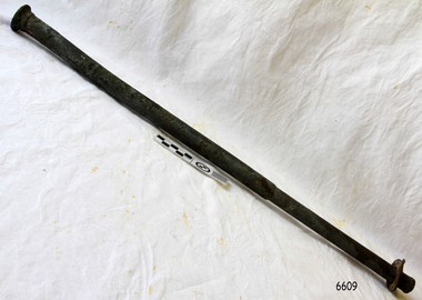
Functional object - Rod, Approx. 1871
This rod was salvaged from the American three-masted wooden clipper ship, Eric the Red, named after the Viking discoverer, Eric the Red. The ship first traded in coal between America and Britain and later traded in guano nitrates from South America. In 1879 its hull was re-metalled and the vessel was in first class condition. On 10th June 1880 Eric the Red departed New York under the command of Captain Z Allen, with 24 crew plus two passengers. It was heading for Melbourne and then Sydney. The ship was commissioned by American trade representatives to carry a special cargo of 500 American exhibits for the U.S.A. pavilion at Melbourne’s first International Exhibition. The items included furniture, ironmongery, wines, chemicals, dental and surgical instruments, paper, cages, bronze lamp trimmings, axles, stamped ware, astronomical and time globes, and samples of corn and the choicest of leaf tobacco. Also on board was general merchandise such as cases of kerosene and turpentine, brooms, Bristol's Sarsaparilla, Wheeler and Wilson sewing machines, Wheeler’s thresher machine, axe handles and tools, cases of silver plate, toys, pianos and organs, carriages and Yankee notions. The ship had been at sea for 85 days when, on 4th September 1880, it hit the Otway Reef on the southwest coast of Victoria and was quickly wrecked. Captain and crew ended up on floating parts, or in the long boat or the sea. He was amongst the 23 battered and injured men who were rescued by the steamer Dawn and later taken to Warrnambool, where they received great hospitality and care. Four men lost their lives; three crew and one passenger. Captain Allen took the train back to Melbourne and then returned to America. The captain and crew of the Dawn were recognised by the United States Government in July 1881 for their humane efforts, being thanked and presented with substantial monetary rewards, medals and gifts. The salvaging ship Pharos collected Wheeler and Wilson sewing machines, nests of boxes, bottles of Bristol’s sarsaparilla, pieces of common American chairs, axe handles, a Wheelers’ Patent thresher and a sailor’s trunk with the words “A. James” on the front. A ship’s flag board bearing the words “Eric the Red” was found on the deckhouse; finally, those on board the Pharos had found the name of the wrecked vessel. The government steamer Victoria and a steamer S.S. Otway picked up flotsam and wreckage. A whole side of the hull and three large pieces of the other side of the hull, with some of the copper sheathing stripped off, had floated onto Point Franklin. Some of the vessel's yards and portions of its masts were on shore with pieces of canvas attached, confirming that the vessel had been under sail. On shore were many cases of Diamond Oil kerosene labelled R. W. Cameron and Company, New York. large planks of red pine, portions of a small white boat and a large, well-used oar. There were sewing machines, some consigned to ‘Long and Co.”, and notions, axe and scythe handles, hay forks, wooden pegs, rolls of wire, some branded “T.S” and Co, Melbourne”, and kegs of nails branded “A.T. and Co.” from the factory of A. Field and Son, Taunton, Massachusetts. Other cargo remains included croquet balls and mallets, buggy fittings, rat traps, perfumery, cutlery and Douay Bibles, clocks, bicycles, chairs, a flywheel, a cooking stove, timber, boxes, pianos, organs, wooden clothes pegs and a ladder. There were three cases of goods meant for the Exhibition Other items salvaged from amongst the debris floating in the sea were chairs, doors, musical instruments, washing boards, nests of trunks and flycatchers. Most of the goods were saturated and smelt of kerosene. A section of the hull lies buried in the sand at Parker River Beach. An anchor with a chain is embedded in the rocks east of Point Franklin and a second anchor, thought to be from Eric the Red, is on display at the Cape Otway light station. A life belt was once on the veranda of Rivernook Guest House in Princetown with the words “ERIC THE RED / BOSTON”. Parts of the ship are on display at Bimbi Park Caravan Park and Apollo Bay Museum. Flagstaff Hill Maritime Village also has several artefacts from the wreck. There seemed to be no personal luggage or clothing. “The Eric the Red is historically significant as one of Victoria's major 19th century shipwrecks. (Heritage Victoria Eric the Red; HV ID 239) The wreck led to the provision of an additional warning light placed below the Cape Otway lighthouse to alert mariners to the location of Otway Reef. The site is archaeologically significant for its remains of a large and varied cargo and ship's fittings being scattered over a wide area. The site is recreationally and aesthetically significant as it is one of the few sites along this coast where tourists can visit identifiable remains of a large wooden shipwreck, and for its location set against the background of Cape Otway, Bass Strait, and the Cape Otway lighthouse.“ (Victorian Heritage Database Registration Number S239, Official Number 8745 USA)Iron rod with flat lugged washer. The rod is made of a heavy metal with encrustations and signs of rusting on the surface. It is stepped down in diameter mid-shaft and is slightly bowed on the narrower end. The narrow end flares out slightly in the last few centimetres with a burred foot and has a circular head on the wider end. The washer on the narrower end cannot move past the centre or the narrow end of the rod. The washer is a different metal from the rod and has a small lug jutting out along the circumference in one position. The rod was recovered from the wreck of the ship the Eric the Red.flagstaff hill, warrnambool, shipwrecked-coast, flagstaff-hill, flagstaff-hill-maritime-museum, maritime-museum, shipwreck-coast, flagstaff-hill-maritime-village, rod, iron-rod, eric the red, steamer dawn, cape otway reef, 1880, captain allen, usa pavillion, melbourne exhibition, melbourne international exhibition, captain jones, medal, united states government, pharos, a. james, flag board, steamer victoria, steamer otway, diamond oil, r w cameron and company, long and co., t s and co melbourne, a. field and son, taunton, massachusetts, ketch apollo, ship nail -
 Federation University Historical Collection
Document - Correspondence, Richard Squire Mining Correspondence
Seems that Tom pays Ned's wages. Numerous bores were sunk , some were opened out and driven in the direction of the reef. Numerous Cross cuts were also made from the main tunnel.Unless otherwise stated the letters are from Dad (Richard Squire) to Tom, Hazel & Kiddies all. .1) Handwritten two page letter from Richard Squire to 'Tom & Hazel & little men' with information regarding the Leigh River Tunnel at Mount Mercer, dated 6/8/28. .2) Handwritten three page letter with information regarding mining operations dated 27.6.29. .3) Handwritten three page letter from Richard Squire to 'Tom & Hazel & Flock' with queries regarding the health of one of their children, other personal information and information regarding mining operations dated 18/7/29. .4) Handwritten one page letter from Richard Squire to 'Tom' dated 20/7/29, regarding the enclosed handwritten receipt with stamp for Call of two shares costing 8 pounds 7 shillings and 2 pence in Leigh River Tunnel Syndicate from Richard Squire dated 13th July 1927. .5) Handwritten two page letter from Richard Squire to 'Tom & Hazel & Pinchers' regarding his health, other personal information and information about the four page report of position of work at 'Leigh River Tunnel' enclosed. The letter is dated 29/11/29 and the report dated Nov 28th 29. .6) Handwritten two page letter with personal information and a suggestion that Tom learn to swim dated 13th Jan 30. .7) Handwritten two page report by Richard Squire regarding Leigh River Tunnel Syndicate plus a one page 'Rough Section' drawing of the tunnel dated 29th April 1930. .8) Typed one page report by Richard Squire regarding Leigh River Tunnel Syndicate and the findings of a new shaft dated 9th December 30. .9) Handwritten one page letter by Richard Squire to 'Tom' regarding mining operations and four handwritten receipts for payment of Calls from Richard Squire and Mr H McLeod and Mr E McLeod with stamps. .10) Handwritten two page letter regarding a meeting he had with the Secretary for Mines, Mr Whitehead dated 22 Feb 1931. .11) Handwritten two page letter regarding the difficulties in financing the mining operation occasioned by the interference of the government department dated 12th Mar 31. .12) Handwritten one page letter regarding the delay in the submission of his letter to the Gold Committee and with details of plans he had sent to Tom separately, dated 1st April 31. .13) Handwritten two page letter by Richard Squire to 'Tom' regarding personal matters including his health and also information regarding Tunnel work, dated May 11th 31. .14) Handwritten two page letter regarding the mine work, how his new employee, Ned, was going and also his health, dated Thur 21st May 31. .15) Handwritten two page letter regarding the Tunnel progress and financial matters dated Tue 26th May. .16) Handwritten three page letter regarding the Tunnel progress dated Thur June 11th. .17) Handwritten two page letter regarding the Tunnel progress, an issue relating to Ned's taxation assessment and his own health, dated 28th June 31. .18) Handwritten three page letter with detailed information on the Tunnel progress and information regarding his health, dated Thur July 23rd. .19) Handwritten two page letter regarding the Tunnel progress and some personal greetings, dated Thur July 30th 31. .20) Handwritten two page letter regarding the Tunnel progress, an agreement with Messrs Read & Peers? and a renaming of a Prospect as Lawaluk instead of Mount Mercer, dated Sun 2nd Aug 31. .21) Handwritten three page letter regarding the Tunnel progress, the lease agreement on Mr Read's property at Mount Mercer which he had been unable to pay and a parsley root remedy which a Ballarat Chinese herbalist had prescribed for his catarrh and had been effective, dated Thur 13th Aug 31. .22) Handwritten two page letter regarding the efficacy of the parsley (root) water in healing his catarrh and detailed progress report on the Tunnel which showed a little gold in the uncovered 'wash', dated Mon 24th Aug. .23) Handwritten three page letter regarding the progress of the Tunnel and one of the bores sunk also mentions his health, dated Mon Sept 7th. .24) Handwritten three page letter regarding the Tunnel progress in detail and an account of his illness, dated Thur 24th Sept. .25) Handwritten two page letter regarding the Tunnel progress in detail and his health which had been poor, dated Thur Oct 8th 31. .26) Handwritten four page letter regarding the Tunnel progress in detail, dated Thur Oct 22. .27) Handwritten four page letter regarding a detailed report of the Tunnel progress including the news of some show of gold and other personal matters including advising Tom not to drive there when he would have to drive home in the dark because of the accidents caused by 'Boosy Drivers', dated Thur Nov 19th 31. .28) Handwritten two page letter regarding the continued promising Tunnel progress, dated Thur Nov 26th. .29) Handwritten two page letter regarding Tunnel progress and personal matters relating to the coming Christmas visit, dated Thur Dec 3rd 1931. .30) Handwritten two page letter regarding Tunnel progress and personal matters regarding the impending visit by the family, dated Sun Dec 6th 31. .31) Handwritten two page letter regarding his health and the treatment proscribed by a Chinese herbalist and also some information about his expenses, dated Sunday 25/1/32. .32) Handwritten four page letter regarding Tunnel progress including a small diagram and further information on his health, dated Thur 25th Feb 32. .33) Handwritten three page letter regarding Tunnel progress and some personal and family information, dated Mon 21st 32. .34) Handwritten one page letter regarding some personal matters and information about the Tunnel progress, dated Thus 31st Mar. .35) Handwritten two page letter regarding detailed information about the Tunnel as well as a one page diagram of the Drives being excavated, dated Sun night 3rd April. .36). Handwritten three page letter from his home in Prahran regarding a mixture of personal matters and matters relating to the Tunnel, dated 18/4/32. .37) Handwritten one page letter regarding enclosed three shares which were to be placed as he was very short of funds, dated 19-4-32. .38) Handwritten two page letter from his home in Prahran regarding work carried out by Ned at the Tunnel and family matters, dated 6/5/32. .39) Handwritten one page letter from his home in Prahran regarding work carried out by Ned at the Tunnel, dated 10/5/32 plus an attached one page letter written by Ned (E. Woodlook) to 'Mr Squire' regarding regarding Tunnel progress, dated Saturday. .40) Handwritten two page letter from his home in Prahran regarding Tunnel progress and some personal matters, dated 27/5/32 plus an attached one page letter written by Ned to 'Mr Squire' regarding Tunnel progress and with the information that the rats were bad in Richard's hut, dated Friday. .41) Handwritten two page letter from his home in Prahran regarding Tunnel progress, dated 3/6/32 plus a two page letter written by E.Woodlock to 'Mr Squire' regarding Tunnel progress as well as person matters regarding his health, dated Friday (27th May 32 written in pencil by Richard). .42) Handwritten three page letter from his home in Prahran regarding tunnel progress and financial matters, also detailed information about the Madison's Tunnel, dated 8/6/32, plus a one page letter from E. Woodlock (Ned) to 'Mr Squire' regarding Tunnel progress dated Saturday (4 June, 32). .43) Handwritten three page letter from his home Prahran regarding a sketch he had made of Madison's Tunnel and the Mercer Shaft (not present) and the similarity of other mines with barely Payable gold, dated 13/6/32. plus a one page letter from E. Woodlock to 'Mr Squire' regarding Tunnel progress dated Saturday. .44) Handwritten one page letter by Richard Squire to 'Tom' from his home in Prahran with some personal information as well as the hope to return to Mt Mercer as he felt he was now well, not dated, plus a two page letter from E. Woodlock to 'Mr Squire' regarding duty stamps sent and Tunnel progress dated Saturday. .45) Handwritten two page letter from his home in Prahran regarding the progress of the Tunnel, dated 21/6/32, plus a one page letter from E. Woodlock regarding the progress of the Tunnel work, dated Monday (20/6/32). .46) Handwritten three page letter from his home in Prahran regarding the price of gold and the effect that mining Payable gold in the Madison Tunnel could have, dated 27/6/32. .47) Handwritten three page letter by Richard Squire to Tom, Hazel & Kiddies all' from his home in Prahran regarding his thoughts on the Madison Tunnel at Piggoreet, dated Mon 4th July 32, plus two one page letters by E Woodlock to 'Mr Squire' regarding the Tunnel work and more personal things, dated Wednesday (June 29th 32) and Saturday (July 2nd). .48) Handwritten two page letter from his home in Prahran regarding his intention to return to the diggings in a small car procured for his use and his intention to re-peg the Leigh River Lease in another name, dated Sun 17/7/32, plus a two page and a one page letter by E Woodlock to 'Mr Squire' regarding progress at the Tunnel dated Thursday (7th July) and Tuesday (12th July 32). .49) Handwritten one page letter by E Woodlock to Mr Squire detailing the tunnel work and other work related details dated Saturday (16th July 32), plus a one page letter by 'Dad' (Richard Squire) to 'Tom, Hazel & Kiddies all' regarding the letter sent by Ned (E Woodlock) and the ongoing work. He also talks about the health of Mam, his wife, dated 19th July 32. .50) Handwritten one page letter regarding the work at the tunnel and with the information that he was to finally return to the mine, dated 22/7/32, plus a one page letter by E Woodlock to Mr Squire about the ongoing work, dated Wednesday (20th July). .51) Handwritten two page letter written from Mt Mercer, regarding the works in the Mt Mercer Tunnel (mentioning South Cockloft). He also details that the drive from town (Melbourne) took 4 gallons of petrol, dated Thur 28th July 32. .52) Handwritten 3 page letter detailing the work carried on at the tunnels and with the information that underground gas had halted work temporarily. He was keen that Tom should visit one weekend soon, dated Sat 6th Aug 1932. .53) Handwritten four page letter detailing the work and new bore holes near Madisons Tunnel. The No 1 tunnel work had to be suspended due to continued gas filling the diggings every time the barometric pressure dropped. On the last page was a rough sketch of the area which was being worked, dated 19th Aug 32. .54) Handwritten two page letter regarding Tom's proposed visit to the site and some plans that he should bring with him. He also spoke of a pup that he was housing till Tom came, dated 21/8/32. .55) Handwritten one page letter encouraging Tom to bring skid chains for his vehicle as the road was muddy when he came on the weekend. He gave a brief account of the work and of the pup's progress, dated 25/8/32 .56) Handwritten three page letter regarding the weather and the relief he felt at knowing Tom and his companions had arrived safely home. He also thanked Tom for the cheques for Ned and detailed a little of the work at the tunnel and the need for more explosives as well as the fact that they had had to put a lock on the door of the hut to stop intruders, dated Sun Sept 4th 32. .57) Handwritten one page letter regarding the ongoing work at the tunnel, dated Thur Sept 8/32. .58) Handwritten two page letter written from Prahran, regarding his trip home, work at the tunnel and with information about the enclosed receipts, dated 16/9/32. Also included was a one page letter from E Woodlock to Mr Squire regarding the work at the tunnel, dated Wednesday. .59) Handwritten one page letter from Dad (Richard Squire) to 'Tom, Hazel & Kiddies all' written from Mt Mercer, regarding the work at the tunnel and the effect that 2 inches of rain had on the work, dated Wed Sept 20th 32. .60) Handwritten two page letter regarding the work at the tunnel and with the information that Mr Read who owned the property where the tunnel was located, had a serious accident in Melbourne, dated Thur 29th Sept 30 (this 1930 date is a mistake as the information contained in this letter follows on from his previous letter dated 20th Sept 32). .61) Handwritten one page letter regarding the work at the tunnel with the encouraging information that flecks of gold were found in about half a dish (mining pan), dated Thur Sept 22nd. .62) Handwritten two page letter regarding the progress at the tunnel and the difficulties of the work and thanks for Ned's cheque. Also mentioned was the information that Mr Read had a fractured pelvis and would be in hospital for two months, so Mrs Read with her father was looking after the shearing, dated Thur 6th Oct. .63) Handwritten two page letter with a third page of a diagram of a cross section of the Leigh River Tunnel, including the new tunnel and Madisons tunnel, with detailed description of the work in the tunnel, dated Sat 8th Oct. .64) Handwritten two page letter written from Prahran, giving detailed information of the tunnel and the expected outcome of the work. He also commented that he was to visit Mr Read in hospital, dated 14/10/32. .65) Handwritten two page letter written from Mt Mercer, giving information about the work in the tunnel and his visit to Mr Read, dated Wed 19th Oct. Enclosed also was a one page letter from E Woodlock to Mr Squire giving an account of his work in the tunnel, dated Thursday. .66) Handwritten one page letter regarding the work in the tunnel, dated Sun Oct 23/32. .67) Handwritten two page letter from Dad & Jim (Richard Squire) to 'Tom, Hazel & Kiddies all' regarding the receipt of Ned's wages cheque and the insurance of Ned's person as well as a detailed description of the tunnel and its relationship to Madisons Tunnel. He also gives some indication of his health, dated Tue Nov 1st 32. .68) Handwritten on page letter written from Prahran, giving a small amount of information about the tunnel work as well as his visit to see Mr Read and some personal information, undated. Enclosed also is a one page letter by E Woodlock to Mr Squire about the work in the tunnel, dated Thursday. .69) Handwritten one page letter with little information, dated 11/11/32. Also enclosed is a one page letter from E Woodlock to Mr Squire about the work in the tunnel, dated Thursday. .70) Handwritten three page letter with detailed information about the tunnel work and an aside about Jim's help and the he suffered from "Imaginitis imagines he sees a speck of gold in every bit of gravel met", dated 10/11/32. .71) Handwritten two page letter with detailed information on the work as their tunnel crossed with the old Madison Tunnel, dated Thur 17th Nov. .72) Handwritten three page letter detailing information on an application for a 500 acre lease which was posted at the Grenville Post Office and how it would impact on their lease. The upshot was that their leases would need to be re-pegged and the fee to publish a Notice of Application on their Leigh River claim was necessary to pay and he wondered if one of their investors would pay the 10 pounds necessary to secure the claim. He also spoke of perhaps forming a Company to put a plant on their Mt Mercer shaft as he felt that the gold would be of a payable quantity, dated Sunday 20th Nov, Also included was a note written by Ned (Edward Woodlock) who had copied the Notice of Application. .73) Handwritten two page letter detailing information found in Madison's Tunnel as it related to their own tunnels, particularly No 2 tunnel and how far he felt he would need to tunnel to reach an improvement in the 'wash', dated Thur 24th Nov. .74) Handwritten one page letter thanking him for the cheque the investor, Mr Wilkinson had provided for the Notice of Application for the Mt Mercer old Lease of 828 acres. He also gave some information about how it was originally farm labourers who only worked this lease and only when they had no other work. He also gave some personal information about Mam's birthday, dated Mon Nov 28th 32. .75) Handwritten two page letter by Dad (Richard Squire) to 'Tom, Hazel & Kiddies 3' written from Prahran, telling them that they had received Ned Cheque and that that Jim and He had come home. He also detailed an incident that Jim had had with a tyre blowout whilst on his way to get explosives and post the Notice of Application in the Warden's Office in Ballarat. The stub axle had bent and Jim had to ride a bike to get a new one and after changing the inner tube of the tyre they were able to drive back to Melbourne and were in the process on having the tyre re-treaded, dated 6/12/32. .76) Handwritten one page letter explaining how he and Mam had contracted colds and that his kidneys had some of their of trouble. He hoped to return to Mt Mercer on the weekend, dated 18th Jan 33. Also included was a handwritten two page letter by E Woodlock to Mr Squire giving information about the tunnel work, an injury to his hand and the fact that he had only 3 picks that were any good. He also asked for some vegetables, tomatoes and bacon when Richard returned, dated Saturday. .77) Handwritten one page letter written from Mt Mercer, giving information about the tunnel work, now 97'6" in and how he had expected to have already come upon the Madison's gold bearing gravel wash, dated Wed 25th Jan 33. .78) Handwritten two page letter with detailed information about how the tunnel had cut across a second Madison's tunnel and the prospects in this tunnel looked more promising. He also stated that he had not been well the last few days, dated Frid 27th 33 .79) Handwritten one page letter with information about the shotty gold found and the tunnel work and that he would test the value of the wash where the gold was found, dated Mon 30th Jan. .80) Handwritten short note of one page giving sketchy information about the tunnel work, dated Tue 31st Jan 33. .81) Handwritten two page letter giving information about his dealings with the Secretary for Mines relating to the fact that because the application for lease was identical to the old lease, they therefore should not need to pay for a full survey costing 7 pounds, just an inspection. He also detailed the workings and asks for more parsley roots to be sent to him, dated Thur Feb 9th 33. .82) Handwritten one page letter stating that he had received Ned's cheque and information about the workings, the coarse gold found and the fact they were going home for fresh food, dated Tue 14th 33. .83) Handwritten two page letter giving detailed information on the progress of the tunnelling as well as the information that Len and Max had come to visit the site and that Len had brought with him Keating, who he detested and pondered the reason for his bringing the man. As they were leaving Max "told Ned he thought they were going down to Ice Mam". Richard was worried about paying the 7 pounds ten shillings for the Department of Mines survey and was loath to put in another 20 pounds for another share of the mine to pay for it. He gave his thanks for a parcel of parsley he'd received , dated Tue 21st Feb 33. .84) Handwritten two page letter written saying that he had received Ned's cheque (for wages) and giving detailed information on the progress and for the need to timber the drive and have the bottom stoped up. He had no timber or laths left and was concerned about the cost necessary to satisfy the Mines Department. He mentions the possibility of insolvency. Fine gold had been found but not like the Madison's tunnel, dated Tue 28th Feb 33. .85) Handwritten two page letter written giving detailed information of the progress in the tunnel and with the expectation that they would soon meet the same wash which was in Madison's Tunnel. He also personal information about his health. the parsley roots received and the apples which Jim had "burgled", dated Sun 5th Mar 33. .86) Handwritten four page letter by with a very detailed account of the progress of the tunnelling and the reason why the expected intersection with the Madison wash did not occur, but with the hope that this intersection would soon occur, then they would be able to meet expenses. He also talked about not being able to pay for the lease but had the hope they they would not be too rigid in their case. He added some personal information about Jim not having the makings of a miner, catching rabbits "for the pot" and the fact that Mr Read was so much better that he was able to ride his horse, dated Sat 11th Mar 33. .87) Handwritten one page letter written from Prahran, acknowledging the receipt of Ned's cheque, a note about the work at the tunnel and some personal information, dated 21/3/33. .88) Handwritten one page letter written from Mt Mercer, saying that there was little change in the tunnel but that he was would open a cross cut north, dated Thur 23 March 33. .89) Handwritten note of a half page telling them that he had cross cut the tunnel, dated Sat 25th Mar. .90) Handwritten one page letter with progress of the tunnelling and where it is in relation to Madison's Tunnel, dated Thur 30th Mar 33. .91) Handwritten three page letter with the first part of the letter talking about the personal and financial worries he and his family had with travelling and mining expenses as well as Ned's wages which could not have been managed without Judy's little car, Jim's help and the payment of Ned's wages by Tom. He went on to give detailed information of the tunnelling and then talked about a letter received by the Department of Mines regarding the non payment of the lease and that a Notice of Abandonment would be published if not paid. Lastly he talked about the struggle he had had with this process and that it was only because of Tom's help that he had been able to continue this far, dated Sun 2/4/33. .92) A one page letter with information about the progress as well as the information that he had not heard from the Mines Department regarding the lease, and the the 1000 sq ft Miners Right Claim was secure, dated Thur 6th April. .93) A three page letter with detailed information about the work in the tunnel and also detailed explanation of the leases he has pegged and repegged. He also thanked Tom for paying the balance which was owed to the Department and informed Tom that he was going home, dated Tues 11th April 33. .94) A four page letter written from Prahran, thanking Tom for Ned's cheque and with information about the work still being carried on by Ned. He also talked about the pegging of the Mt Mercer claim and the cost of the advertisement and application and survey fees to secure the site as well as his opinion of the probable value of the gold from this site. He also stated that he really needed more investment from those who had initially invested with him or from new investors, dated 17/4/33. Included was a one page letter from Edward Woodlock (Ned) to Mr Squire regarding the work he was carrying out at the tunnel, dated Saturday. .95) A three page letterwritten from Mt Mercer, regarding the work in the tunnel and the quality of the gold found and the direction they will take. He also stated that he was posting letters to the original investors to see if they would contribute to the cost of the lease and also talked about another man who had a Notice of Application posted at Grenville for the water rights for a 25 miles long area and a dam. His Capital is 300 pounds and the supposition is that he wants to 'unwater' the leads, dated Frid 20th April. .96) A one page letter regarding the continued work in the tunnel and how his suppositions seemed to be correct, dated Thur 27th April 33. .97) A three page letter thanking Tom for Ned's cheque of 6 pounds 7 shillings and 6 pence. He also gave detailed information about the tunneling and the type of ground found and his next intentions. He also gave further information about the Notice of Application at Grenville which was posted by B Ryan, Agent for Western Deep Leads Coy Limited for 6000 acres, dated Sun 30th April 33. As well is a note detailing the information copied from the Notice. .98) A two page handwritten letter detailing the work being carried out as well as a complaint that he had not heard from the men he had written to, dated Thur 4th May 33. .99) A one page handwritten letter regarding the tunnel work and informing Tom that the gold found is shotty, dated Sat 6th May 33. .100) A four page handwritten letter written from Prahran, detailing the tunnel work and informing that the gold prospects were better in no.1 cross cut south and there was also payable fair gold where they were currently working, if worked in bulk. He also talked about the possibility of new investors as the old ones had not responded to his letter and the necessity of securing the leases, dated 11th May 1933. .101) A one page handwritten letter by E. Woodlock (Ned) to Mr Squire regarding the work going on, dated Thursday. .102) A six page handwritten letter written from Prahran historically detailing the acquisition of the two leases at Mt Mercer, 35 years earlier, with M C Donnely/Donney and Jas Clements, including Madisons. He goes on to clarify Tom's suggestion regarding the Leases and the Companies to be floated, then details the the shafts, bores, tunnels and Deep Leads held in the leases and then goes on to say what his next steps would be, dated 13th May 33. .103) A two page letter written from Mt Mercer detailing the continued work in the tunnel with the added information that because of the incline it was taking two men to push the truck up the tunnel. Richard also told of the need to take more parsley water for his condition, dated Thur 18th 33. .104) A three page letter with a very detailed description of the work in the tunnel. Richard also told that he had run out of metal rails and was having to use timber as a substitute. He was also to re-peg the North and South Leases in the morning, dated Sun 21st May 33. .105) A two page letter detailing the work in the tunnel and saying that there was a hundred feet of rail locked in by a fall in the No.2 Tunnel and he was hoping to get them out to replace the wooden rails as they made for heavy work on the inclines. He also said that he had a letter from the Department telling him to communicate with the Surveyor in Ballarat, dated Wed 24th May. .106) A three page letter acknowledging Ned's cheque as well as information about the work in the tunnel, including that he had been able to retrieve 45 feet of rail and would get more when needed. He said he was pleased that Tom and Mr Wilkinson were making a trip on Saturday to see him. He talked of the weather and the fact that the bread was a week old, so to bring enough to last till the Monday. Among other things he also spoke of Tom revising the Plans and also having a Share book printed and the name was to be the Ballarat Deep Leads Extension for which there could possibly be 3 Companies, dated Sun 28th May. .107) A one page letter with information about the work in the tunnel and also a weather update and the best way to come, dated Wed 31 May 33. .108) A two page letter written from Prahran, explaining a visit to the Leigh River Shaft to get whim rope, whip wheels and sundry items. He shifted some equipment and built a new forge and was to fix and mount a windlass and rope to enable Ned to get the truck up the incline of the tunnel. He also spoke of the work being undertake by Ned then when on to more personal correspondence about a birthday present for one of Tom's boys, dated 9/6/33. .109) A two page letter acknowledging receipt of the 'Prospectus of the Ballarat Deep Leads Extension Syndicate' and 'Share Certificate'. The No.1 Lease was in Ned's name and the No.2 Lease was in Jim's name to avoid inquisitive interest. Jim logged a Notice of Application and paid the fees. Richard acknowledged receipt of Ned's cheque and asked for 5 pounds as his finances were 'rather tight', dated 14/6/33. Included was a 1 page letter from Ned to Mr Squire regarding the work in the mine, dated Saturday. .110) A one page letter written from Mt Mercer giving information about what was happening in the new x cut N near the mouth of the tunnel, dated Friday 16/6/33. .111) A one page letter telling about the work and that he had fixed an old shed of Mr Reads for the forge. Mr Read and Mr Cameron visited and Richard was hopeful that Mr Cameron, the owner of the land in the North Lease would be easy as regards an agreement, dated June 22/33. .112) A two page letter which talked about his health, the mine, the local J.P. who had lost his eye in a shearing accident and the surveyors visit, He also spoke about contacting the Gold Mines Ltd and the Berry Leads Company, dated Tue 27th 33. Also included was a letter to the Mines Department and a receipt from the Mines Department for the sum of 7 pounds 10 shillings as well as the Lease Applications from the newspaper dated June 13th 1933. .113) A two page letter complaining of the charge made by the Mines Department for a Surveyors Inspection. He also wrote of trying to set up a float for the mine which he would do when he returned home.He also explained the current findings at the mine, dated Sun 2nd July 1933. .114) A one page note written from Prahran informing Tom that he had not yet heard from Gold Mines Ltd and also that there was a hitch with the lease on the house, but this was to hopefully be fixed the following day. He also spoke of Tom's trip home (completed in tow), dated 18/7/33. .115) A two page letter recounting some of the difficulties they were having with the new owners of the house they leased in Prahran. He also spoke of the fact that the Mines Department had requested another 10 pounds although they had not yet completed the survey on either mine, dated 21/7/1933. Also included was a one page letter from E. Woodlock (Ned) to Mr Squire about the workings, dated Tuesday and a letter from the Gold Mines of Australia Limited saying that the information he had supplied was now with their engineers, dated 20th July, 1933. .116) A three page letter written from Armidale saying that Mam (his wife) was fretting with the move to this house. He also told of the rejection by the Gold Mines of Australia Limited of his proposal to invest in his Mt Merser Mine, stating that he believed that Jim Clements who had been the manager when the mine had previously been opened, had most likely "thrown all the cold water he could" on the proposal. He spoke at length about how this man had run the mine into the ground and his own involvement with the winding up of the company. He went on to say that he would approach Ryall to see if he was interested in investing, dated 28/7/33. Included was the letter from Gold Mines of Australia Limited, dated 26th July, 1933. .117) A two page letter written from Prahran telling of the move to another house where Mam was quite settled. He also wrote of the work Ned was carrying out at the mine as well as personal and family news. He wrote that as he had not heard from Ryall, he would visit him the following day, dated 6/8/33. Also included was a two page letter from E Woodlock to Mr Squire giving detailed information of the progress at the tunnel, as well as asking for a new pair of boots as the ground was so wet his were letting in the water, dated Thursday. .118) A two page letter explaining about a letter he received from Mr Cameron who believed he had found gold as well as some personal information and his health, dated 8/8/33. Also included was a one page letter from Neil W Cameron to R B Squire telling about some specks of gold he'd found in a post hole, dated July 31st 33. Thirdly was a one page letter from Ned to Mr Squire explaining the work he was doing in the tunnel, dated Saturday. .119) A one page note saying that he did not like the enclosed 2 copies of the typed Agreement of the Leigh River Gold Mining Company with William Ryall, but asked Tom's advice. dated 9/8/33. .120) A two page letter dealing mainly about the work going on at the new house and the settling in process. He also wrote about the proposed Agreement with Ryall, dated 11/8/33. Also included was a one page letter from Mr Ryall to R B Squire from which part of the left hand side had been severed, dated 10th August 1933. .121) A one page note from R B Squire to W Ryall dated 14/8/33, with attached one page of information and figures. Also attached a one page letter from R B Squire to W Ryall asking if Ryall would be interested viewing the plans for an alluvial mining proposition, dated 27/7/33. .122) A three page letter mainly about the visit to Ryall and a Mr Cundy about the proposed agreement with his concerns about the language and terms of the agreement, dated Sun 21st 33. Also included was a letter from Ned to Mr Squire about the continued work in the tunnel and the fact that two of the pick heads had cracked and would have to be fixed, dated Thursday. .123) A two page letter dealing with a meeting had with Ryall and others in a private office regarding the interest in investing in the mining proposition, dated 23/8/33. .124) A four page letter dealing mainly with the work at the tunnel and exploratory diggings at the spot Mr Cameron had written about as well as the damage done to the car on the way to the workings, dated 29/8/33. .125) A one page letter telling of a proposed meeting with Mr Taylor and a Mr Bowler, who may turn out to be Alan Bowler who he knew, regarding the Mr Mercer Float scheduled for the following day, dated 30/8/33. .126) A five page letter explaining the content of the meeting held with Mr Bowler, who represented an English consortium which was interested in the Mt Mercer site. He explained the terms that the consortium would offer if they went ahead, This included 25 % shares in the mine but no money, which he bemoaned because of the shortness of their cash reserves. He went on to detail the 4 distinct deposits of wash in this field, which he believed were unique in the Ballarat district. He also stated that he had not heard from Mr Ryall. He closed by talking about the water levels in the mine, dated 1/9/33. .127) A two page letter saying that he had written an 11 page report on the Mt Mercer field for the English consortium as well as a private letter for the chairman.He also reported that he had been to see Ryall. Neither party knew that he was talking to the other. added was some personal information, dated 6/9/33. .128) A one page letter telling of a meeting with Mr Bowler and Mr Tayler who carefully went through his report. It was then being typed. He believed he had two strong supporters, dated 7/9/33. Also included was a 2 page note from A Bowler to R B Squire asking him to bring the report into the office the following day to be perused and typed, dated Sept 6th 33. .129) A two page letter with personal encouragement for one of the children. The letter then goes on with more information about the meeting with Mr Tayler and Bowler and his impressions of their interest. He also talked about the one of the experts who was to examine the site and also about the report which was now typed and a copy sent to Tom, dated 8/9/33. .130) A one page letter keeping him informed of progress. The expert was away but would be briefed on his return. He also thanked Tom for a cheque, which was used to get the car 'Liz' back in order for the trip to be made with the experts at a later date. He informed Tom of his intention to return to Mt Mercer, dated 13/9/33. .131) A one page letter written from Mt Mercer telling of the trip from Melbourne and the weather. He spoke of what was happening in the tunnel and that he had not yet heard from any of the interested parties, dated Tue 19th Sept. .132) A five page letter written from Prahran with detailed information about the tunnels, the washes and the shows. He also detailed his meeting with Bryant 38 years ago at the No 1 at Carisbrook and how he had given him assistance at that time and subsequently as well as giving his version of a potted history of Bryant, dated 29/9/33. .133) A two page letter with information about the arrival of the chairman of the English group and that Ned had shown Mr Kermode around the site, dated 6/10/33. Also included was a cutting from the Age about the arrival of Mr F W Baker, representing a large English financial group interested in Victorian deep lead propositions, dated Oct 6th. As well were two, one page letters from Ned (E Woodlock) to Tom, regarding the work in the tunnels, the bad air and the hopes of a successful float, dated Tuesday and Wednesday. .134) A one page letter thanking them for the gift of eggs and parsley. He also talked about a letter from Bowler regarding the business of the experts and that their leases would be seen in due course, dated 10/10/33. Included was a one page letter from A Bowler to P B Squires saying that Mt Mercer site was receiving attention but that no decision had as yet been made, dated Oct 9th 1933. .135) A three page letter written from Prahran giving information about Richards visit and conversation with Mr Ryall, who indicated that no decision had as yet been made regarding his proposal. He also included some personal information about members of the family, dated 18/10/33. Included was a one page letter from Ned (E Woodlock) to Tom with information about the tunnelling progress in no.2 tunnel and the bad air that drove them out for a time, dated Saturday. .136) A one page letter containing a brief update on the state of affairs , dated 20/10/33. Included was a one page letter from Ned to Mr Squire with an information on the progress at the tunnel and with the information that his hands were cracked so badly that he was wearing two socks on each hand, dated Saturday. .137) A one page letter which family news and a paragraph about the figures in his calculations, dated 21/10/33. On the back side was a letter from E Squire (his wife) to Tom, Hazel & boys again with family and personal information, dated 22nd 10/33. .138) A three page letter with the disappointing news that the English consortium would not take up the option on the Mt Mercer lease and gave his opinion that it was self interest that stopped it going ahead. He then gave two options as to the way forward, dated 24/10/33. Also included was a typed one page letter from W C Tayler to R B Squire informing him of a letter stating that the proposal had been turned down, dated 23rd October 1933. .139) A three page letter informing of further developments with Mr Tayler who asked for the plans to be left at the office till the following week as there was another company who may yet be interested to take up the option, dated 27/10/33. .140) A one page letter asking for 9 copies of the old agreement to be typed for the 3 Syndicate members, Rice, Cameron and McNaughton, dated 5/11/33. .141) A three page letter regarding the decision by the Syndicate to reopen the LRG shaft and the practical issues of timber acquisition and probable costs. He then went on to talk about Mam's indisposition and treatment by the herbalist, Goon, dated 8/11/33. Also included was a newspaper clipping from the Age entitled 'Inquiries for properties at Ballarat'. .142) A three page letter giving all the news regarding the agreements, the costs and the way forward. He also spoke of his wife's improvement and other personal information, dated 11/11/33. .143) A two page letter written from Mt Mercer regarding the difficulties in obtaining the timbers and tanks needed to reopen the shaft and the state of all the existing fittings and what would be needed to get the site operational again. His agreement with Mr Read had duly been signed, dated Thurs 16th 33. .144) A two page letter with further information about the progress with acquiring and repairing the shaft site, dated Mon Nov 20th 33. .145) A three page letter informing that the timber for the whim & shaft were being delivered and the area had been cleared out for the poppet heads. The top of the shaft had been cleared ready for re-framing and other work had been carried out. Liz, the car had broken down and Jim was in the process of fixing her. He concluded with information about his and his wife's health, dated Sun 26th Nov 33. .146) A four page letter with news of Mam's health, the problems associated with fixing the car and the floods which stopped Jim from going to Ballarat and washed away the Gary Bridge which affected the mail and had halted work at the shaft, as well as delaying the second delivery of timber, dated Sun Dec 3rd. .147) richard squire, william ryall, jim clements, gold mines of australia limited, e woodlock, ned woodlock, neil w cameron, alan bowler, mr cundy, don mcnaughton, mr rice -
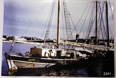 Flagstaff Hill Maritime Museum and Village
Photograph
This coloured photograph of the ketch Reginald M was taken when she was docked at Port Adelaide. The side of the vessel shows the letters "REGINALD M / H.M.C. No. 2 Pt ADEL" - (abbreviation H.M.C. meaning His/Her Majesty's Customs. HISTORY The Reginald M, a two-masted coastal ketch, was owned and built by Mr. Jack (John) Murch of Birkenhead, Port of Adelaide, South Australia to serve the coastal ports of South Australia. Its construction took approximately 6 months and it was launched at Largs Bay in 1922. Its purpose was to carry cargo cheaply and efficiently, and tradition has it that the keel was in fact hewn from two telegraph poles! Its builder frequented all the salvage yards for materials and fittings. The Reginald M had a very shallow draft and a flat bottom that enabled it to sit high and dry at low tide. The flat bottom was also to make the ship able to skim over reefs. Wagons were able to load and unload direct from her side. Her cargo included Guano, Barley, Wool, Horses, Cattle, Timber, Explosives, Potatoes, Shell Grit and Gypsum. In 1931 she weathered a large storm in St Vincents Gulf, SA. Her crew at the time were Owner Mr John H Murch, Wells St, Largs Bay, Skipper, John’s brother Mr R Murch, Murray, son of Mr R Murch and Seaman John Smith Reg Webb purchased Carribie Station, at Marion in the Warooka District, south of Adelaide, in 1921. He cleared the land and farmed sheep and grain. In 1923 he shipped his own wool and grain from Marion Bay, having first carted 300 bags of the barley grain, 12 bags at a time, along the unmade track to the jetty. A photograph dating about 1929 -1942 shows 2 men on the Reginald M, having just landed their fishing catch of a hammer shark. The photograph is stamped “GRENFELL STUDIO PORT LINCLON PRINT” and titled “hammer shark caught on Reginall Emm”. Reg Webb knew the Murch Brothers from Port Adelaide. The brothers had been using their ketch REGINALD M to ship Guano from the Islands, led by Captain Richard Murch. Reg approached them in 1934 about shipping grain from Marion Bay. The brothers visited the bay and thought it was an ideal place. They showed Reg where to stack his grain and they measured up the cliffs. When Reg was ready, they brought down and installed a ninety foot wooden chute. The bags of grain were then individually sent down the chute, landing in a waiting small boat then rowed to REGINALD M, 14 bags at a time. After 10 hours REGINALD M would be fully loaded with 1300 bags of grain and shipped to waiting ports. At one time a wild storm destroyed the chute but it was rebuilt and strengthened. REGINALD M was involved in shipping the grain from there until 1938. In 1940 Able Seaman Allan H Lucas served on Reginald M between September and December, being engaged and discharged from Port of Adelaide. His Certificate of Discharge was signed by ship’s Master W S Murch. It seems that at some stage Reginald M was used as a Customs vessel because a photograph in Flagstaff Hill’s collection shows the text “H.M.C. No. 3, Pt Adelaide” on the bow, the abbreviations standing for “His/Her Majesty’s Customs”. In 1969 the last freight left Marion Bay on the ketch REGINALD M carrying grain, wool and explosives. In late 1970 she was sold to the Mt. Lyell Copper Company, based in Queenstown, Tasmania, to carry explosives. In 1972 the Navy League of Strahan, Tasmania, purchased her for use by the Strahan Sea Cadet Unit and renamed her T.S. Macquarie. In 1974 Mr. Andrew Rennie, of East Brighton, Melbourne, bought her, paying $5,000 and donating a ‘Cadet of the Year” trophy to the Sea Cadets. He sailed her from Strahan to Melbourne, planning to use her for pleasure sailing. In 1975 Reginald M was sold to Melbourne Ferry Company at auction. In 1975 the Reginald M was bought by Flagstaff Maritime Museum for $20,000. She has been restored and is now one of the exhibits, tied up at the dock. Flagstaff Hill Maritime Village’s Collection holds several other artefacts associated with Reginald M. They include - Photographs of the Reginald M, including one photograph of her in Outer Harbour, S.A. dated 1947, with Skipper- R.F. Dale and Owner- John Murch. Another shows her docked at Port Adelaide, with the lettering H.M.C. No. 3 Pt ADEL (standing for His/Her Majesty’s Customs). There is a black and white photo of her at a wharf and another showing a person on board. - a lifebuoy, with Pt Adelaide on it. - a bullet found in pieces of timber when Reginald M was restored in 1979 (References: Flagstaff Hill Fact Sheet “Reginald M”, the book “The Reg Webb Story” compiled by the Warooka & District Museum. Reg Webb’s daughter Lily Ramsay (nee Webb) and her husband Howard, Lizzie Rennie (daughter of owner Andrew Rennie), brochure “Discover the Yorke Peninsula South Australia”, Ketch in Peril; Adelaide Chronicle 9 April 1931, K Gordon & Mary Filmer of Warooka; South Australian Maritime Museum) Thiis photograph is significant because of its connection to the history of the vessel REGINALD M is a coastal trading ketch from South Australia built in 1922. It is one of very few sailing coastal trading vessels still extant, and its flat bottom, single chine shape illustrates a very simple but robust method of construction, compared to other round bilged examples of trading vessels. She is now listed on the Australian Register of Historic Vessels (ARHV Number: HV000562.)Photograph of Reginald M at Port Adelaide. The side of the vessel shows the letters "REGINALD M / H.M.C. No. 2 Pt ADEL" - (abbreviation H.M.C. meaning His/Her Majesty's Customs. Painted on the side of the vessel "REGINALD M / H.M.C. No. 2 Pt ADEL" - flagstaff hill, warrnambool, shipwrecked-coast, flagstaff-hill, flagstaff-hill-maritime-museum, maritime-museum, shipwreck-coast, flagstaff-hill-maritime-village, reginald m, coastal trading ketch, trading vessel, john murch ship builder, port adelaide vessel reginald m, andrew rennie, macquarie training vessel, mt lyell copper company, queenstown navy league, ch murch, reg webb, carribie station, melbourne ferry company, grenfell studio port lincoln, vessel reginald m -
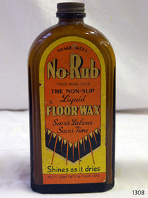 Flagstaff Hill Maritime Museum and Village
Container - Bottle, J R Alexander & Sons Ltd, c. 1936
This bottle labelled No Rub liquid wax proclaims the wonders of No-Rub, no-slip, and shines as it dries. The bottle still contains some of the liquid floor wax, made by J R Alexander & Sons Limited. The company was registered as a limited company from 1924 to 1975. However, the firm's advertisement and referrals from satisfied Melbourne customers, printed in The Argus, Melbourne, on Mach 19th, 1954, states that it made the first shoe polish, Supreme, in Australia as long ago as 1900. The firm made a range of household cleaning products such as floor wax, shoe polish and fabric starch. The J R Alexander & Sons Ltd. No-Rub liquid wax was advertised in various states of Australia from around 1936 until the 1950s. Later advertisements show sketches of the wax containers, which were round bottles or metal cans. The bottle in our collection is likely to be made around the 1960s.Bottle; brown glass with metal cap and yellow, orange and black label on the front. Flat rectangular-shaped bottle with a short neck and rounded shoulders The bottle has a black metal screw top lid and contents inside. There are inscriptions on the label. The bottle contains No Rub Floor Wax. Made by J R Alexander and Sons, of Adelaide, Melbourne, Sydney and BrisbanePrinted on the label: "SHAKE WELL" "No-Rub" TRADE MARK REGD." "THE NON-SLIP / Liquid / FLOOR WAX / Saves Labour / Saves Time" "Shines as it dries" "NETT CONTENTS 15 FLUID OZS"flagstaff hill, flagstaff hill maritime museum and village, warrnambool, maritime museum, maritime village, great ocean road, shipwreck coast, glass technology, bottle, glass bottle, brown glass, cleaning product, floor cleaner, floor polish, domestic cleaner, no-rub, floor wax, non-slip, flat bottle, bottle contents, liquid wax, j r alexander & sons, household cleaning, cleaning products, zippy starch, zippy window cleaner, liquid floor wax, no rub floor wax, supreme shoe polish, rectangular bottle -
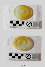 Flagstaff Hill Maritime Museum and Village
Cap Liner, Between 1870 and 1908
This Zinc Cap Porcelain Liner was recovered from the (1908) shipwreck site of the FALLS OF HALLADALE. The purpose of cap liners was to assist with the safe preserving and storage of perishable foodstuffs in an age when refrigeration was generally unavailable. These round, coarse-glass inserts formed part of the screw lids used with the Ball Mason style of canning fruit jars. The liner was placed inside the zinc cap to stop the contents of the jar reacting with the zinc. It prevented the metallic tainting of food as well as the corrosion of the metallic lid. On March 30, 1869, Lewis R Boyd was issued with patent # 88439 for an “Improved Mode of Preventing Corrosion in Metallic Caps”. From the 1870s to the 1950s, large quantities of these liners were produced by a number of glass manufacturing companies. They are consequently difficult to date or identify. “It is assumed that most of the earlier versions of these liners have the name ‘BOYD’S’ or ‘BOYD’ embossed on them. Later versions may or may not have the name included in the lettering”. (http://www.glassbottlemarks.com). Only a few were made of porcelain, the great majority being made first of transparent and later of translucent or opaque glass. The different emblems of triangles, circles, and crosses embossed on the front face of the liners are assumed to signify mould or model types rather than the company that produced them. This particular artefact is one of 14 cap liners that were retrieved from the shipwreck site and are now part of the Flagstaff Hill Maritime Village collection. The Maltese Cross and “BOYD’S GENUINE PORCELAIN LINED” lettering are unique to this piece. However, it is evident from the markings and materials of the other cap liners, that they originally formed sets or series. Six are larger (8 mm depth x 85mm diameter), of greenish hue with ground glass texture, and support the raised emblem of a compass needle. Two are medium-sized (75mm diameter) with two raised dots in a central circle and the lettering “Patd. APR 25.82”. This particular cap liner is likely to have also been one of a mass-produced line being imported from America. The iron-hulled sailing ship FALLS OF HALLADALE was a bulk carrier of general cargo en route from New York to Melbourne and Sydney. In her hold, along with 56,763 tiles of unusual beautiful green American slates (roofing tiles), 5,673 coils of barbed wire, 600 stoves, 500 sewing machines, 6500 gallons of oil, 14400 gallons of benzene, and many other manufactured items, were 117 cases of crockery and glassware. The FALLS OF HALLADALE came aground on a reef off the Peterborough headland at 3 am on the morning of the 15th of November, 1908. The captain and 29 crew members all survived, but her valuable cargo was largely lost, despite two salvage attempts in1908-09 and 1910. The iron-hulled, four-masted barque, the Falls of Halladale, was a bulk carrier of general cargo. She left New York in August 1908 on her way to Melbourne and Sydney. In her hold, along with 56,763 tiles of unusual beautiful green American slates (roofing tiles), 5,673 coils of barbed wire, 600 stoves, 500 sewing machines, 6500 gallons of oil, 14400 gallons of benzene, and many other manufactured items, were 117 cases of crockery and glassware. Three months later and close to her destination, a navigational error caused the Falls of Halladale to be wrecked on a reef off the Peterborough headland at 3 am on the morning of the 15th of November, 1908. The captain and 29 crew members all survived, but her valuable cargo was largely lost, despite two salvage attempts in 1908-09 and 1910. ABOUT THE ‘FALLS OF HALLADALE’ (1886 - 1908) Built: in1886 by Russell & Co., Greenock shipyards, River Clyde, Scotland, UK. The company was founded in 1870 (or 1873) as a partnership between Joseph Russell (1834-1917), Anderson Rodger and William Todd Lithgow. During the period 1882-92 Russell & Co., they standardised designs, which sped up their building process so much that they were able to build 271 ships over that time. In 1886 they introduced a 3000 ton class of sailing vessel with auxiliary engines and brace halyard winches. In 1890 they broke the world output record. Owner: Falls Line, Wright, Breakenridge & Co, 111 Union Street, Glasgow, Scotland. Configuration: Four masted sailing ship; iron-hulled barque; iron masts, wire rigging, fore & aft lifting bridges. Size: Length 83.87m x Breadth 12.6m x Depth 7.23m, Gross tonnage 2085 ton Wrecked: the night of 14th November 1908, Curdies Inlet, Peterborough south west Victoria Crew: 29 The Falls of Halladale was a four-masted sailing ship built-in 1886 in Glasgow, Scotland, for the long-distance cargo trade and was mostly used for Pacific grain trade. She was owned by Wright, Breakenridge & Co of Glasgow and was one of several Falls Line ships, all of which were named after waterfalls in Scotland. The lines flag was of red, blue and white vertical stripes. The Falls of Halladale had a sturdy construction built to carry maximum cargo and able to maintain full sail in heavy gales, one of the last of the ‘windjammers’ that sailed the Trade Route. She and her sister ship, the Falls of Garry, were the first ships in the world to include fore and aft lifting bridges. Previous to this, heavily loaded vessels could have heavy seas break along the full length of the deck, causing serious injury or even death to those on deck. The new, raised catwalk-type decking allowed the crew to move above the deck stormy conditions. This idea is still used today on the most modern tankers and cargo vessels and has proved to be an important step forward in the safety of men at sea. On 4th August 1908, with new sails, 29 crew, and 2800 tons of cargo, the Falls of Halladale left New York, bound for Melbourne and Sydney via the Cape of Good Hope. The cargo on board was valued at £35,000 and included 56,763 tiles of American slate roofing tiles (roof slates), 5,673 coils of barbed wire, 600 stoves, 500 sewing machines, 6,500 gallons of oil, 14,400 gallons of benzene, plumbing iron, 117 cases of crockery and glassware and many other manufactured items. The Falls of Halladale had been at sail for 102 days when, at 3 am on the night of 14th November 1908, under full sail in calm seas with a six knots breeze behind and misleading fog along the coast, the great vessel rose upon an ocean swell and settled on top of a submerged reef near Peterborough on south-west Victoria’s coast. The ship was jammed on the rocks and began filling with water. The crew launched the two lifeboats and all 29 crew landed safely on the beach over 4 miles away at the Bay of Islands. The postmistress at Peterborough, who kept a watch for vessels in distress, saw the stranding and sent out an alert to the local people. A rescue party went to the aid of the sailors and the Port Campbell rocket crew was dispatched, but the crew had all managed to reach shore safely by the time help arrived. The ship stayed in full sail on the rocky shelf for nearly two months, attracting hundreds of sightseers who watched her slowly disintegrate until the pounding seas and dynamiting by salvagers finally broke her back, and her remains disappeared back into deeper water. The valuable cargo was largely lost, despite two salvage attempts in 1908-09 and 1910. Further salvage operations were made from 1974-1986, during which time 22,000 slate tiles were recovered with the help of 14 oil drums to float them, plus personal artefacts, ship fittings, reams of paper and other items. The Court of Marine Inquiry in Melbourne ruled that the foundering of the ship was entirely due to Captain David Wood Thomson’s navigational error, not too technical failure of the Clyde-built ship. The shipwreck is a popular site for divers, about 300m offshore and in 3 – 15m of water. Some of the original cargo can be seen at the site, including pieces of roof slate and coils of barbed wire. The Falls of Halladale shipwreck is listed on the Victorian Heritage Register (No. S255). She was one of the last ships to sail the Trade Routes. She is one of the first vessels to have fore and aft lifting bridges. She is an example of the remains of an International Cargo Ship and also represents aspects of Victoria’s shipping industry. The wreck is protected as a Historic Shipwreck under the Commonwealth Historic Shipwrecks Act (1976). A circular translucent glass disc in good condition with raised upper case lettering around 8mm rim – “BOYD’S GENUINE PORCELAIN LINED” - and a raised central emblem of a Maltese Cross. On the reverse face in the centre of the disc, there is a raised numeral “3”. falls of halladale, wright, breakenridge & co of glasgow, unusual beautiful green american slates (roofing tiles), warrnambool, shipwrecked-coast, flagstaff-hill, flagstaff-hill-maritime-museum, maritime-museum, shipwreck-coast, flagstaff-hill-maritime-village, shipwrecked-artefact, zinc cap porcelain liner, boyd’s genuine porcelain lined, glass lid, opaque disc, food preserving, fruit bottling, cap liner, shipwrecked coast, flagstaff hill maritime museum, shipwreck artefact, 1908 shipwreck -
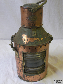 Flagstaff Hill Maritime Museum and Village
Functional object - Marine Lamp, R C Murray & Co Ltd, 1900 -1930
... lamp was made by a very well known maker R C Murray of Glasgow... and navigation the subject lamp was made by a very well known maker R C ...The item is a kerosene marine ships lamp used onboard ships and smaller vessels for general lighting and navigation the subject lamp was made by a very well known maker R C Murray of Glasgow Scotland. During the research several different addresses were found but nothing on the founder or company history. It appears RC Murray made not only marine lamps but lamps for the railways as well. The company is listed in the Scottish Post Office Directories for 1885 to 1886 as manufacturing tinsmiths, lamp makers, coppersmiths, gas fitters, bell hangers and workers in sheet iron, zinc and brass at street numbers 7, 9 and 11 Carlton Court, Bridge St Glasgow. An additional address is at 37 Cavendish St Glasgow listed for 1910, and also at Pollokshaws Road. The writer assumes the company must have moved sometime between 1886 & 1910 to these addresses. The writer at this time cannot ascertain any more historical information regarding the company or its founder, however, lamps made by RC Murray are now collector's items commanding significant sale prices on many auction websites.A significant item used in the marine industry on many ships, the company made kerosene lamps for other industries as well and was a well-known company in the early part of the 20th century.Marine kerosene ships lamp, round copper handle on top and side top is hinged with catch and lever, protruding near top.Inscribed "RC Murray and Co Limited" "Pollokshaws Road Glasgow S.1." flagstaff hill, warrnambool, shipwrecked-coast, flagstaff-hill, flagstaff-hill-maritime-museum, maritime-museum, shipwreck-coast, flagstaff-hill-maritime-village, lamp, lantern, brass lamp, nautical object -
 Flagstaff Hill Maritime Museum and Village
Souvenir - Money box, OXO Ltd, ca. 12-5-1937
Metal money boxes shaped like common familiar objects became popular in the 18th century. In the 20th century, they were used to promote and advertise events and businesses. In the 1950s metal money boxes shaped like a bank building were given away to children by their parents' bank to encourage them to save money. This metal money box was produced for the company of OXO Ltd of London. It was made specifically as a souvenir of the Coronation of King George VI of England, which happened on May 12, 1937. OXO Ltd. still makes OXO stock cubes, which contain a concentrated meat extract. The cubes are used to flavour soups, gravy, casseroles and other food recipes to enhance their flavour. The cubes are removed from their foil wrapper then crumbled into the dish and mixed with the ingredients. Chemist Justus von Liebig worked with engineer George Gilbert of Uruguay to produce Liebig’s Extract of Meat, the forerunner of OXO . In the late 1890s, OXO produced a liquid form of the meat extract and in 1899 registered the OXO trademark worldwide, and in 1900 in the UK. In 1910 the OXO 'penny' cube was in production and proved very popular. The money box is significant for its connection to British Monarch, King George IV, who reigned from 1932-1952. It is also significant for its connection to the OXO cube, a very well knon brand of food additive from the mid-19th century to current times.Souvenir money box, oval cylinder with domed, pull-off lid and framed coin slot, with seams on each side. It once contained six OXO Cubes. The red tin with gold tin has the Royal Insignia of King George VI and Elizabeth on one side and the Royal medallion-style portrait of King George VI and Elizabeth on the other side. There is an inscription on the base and floral decorations on the sides. It was produced for OXO Ltd, Thames House, London, England, to commemorate the coronation of King George V1 and Elizabeth on May 12th 1937.Logo, Royal Insignia: "[Crown] over "G VI R" Medallion-style Portrait image: "GEORGE VI AND ELIZABETH MAY 12TH 1937" around " (Image of King George VI and Elizabeth) " Printed on base: "CORONATION / SOUVENIR MONEY BOX / CONTAINING / 6 OXO CUBES / BRAND / OXO LTD., THAMES HOUSE, / LONDON, ENGLAND."flagstaff hill, flagstaff hill maritime museum and village, warrnambool, maritime museum, maritime village, great ocean road, shipwreck coast, money box, money safe, commemorative money box, coronation king george iv, 1937, vintage money box, oxo cube, numismatics -
 Federation University Historical Collection
Booklet, Ballarat School of Mines, Student Magazine, Second Term, 1910, 1910
Table of Contents: Editorial, Open Night, Process in Ore Treatment at Kalgoorlie, Notes on Surveying, Artesian Wells, Concrete: Its use in mining, Description of the I. R. Process, "Old Boys" at Mt Morgan, News and Notes, Past Students, Correspondence, Answers to Correspondents, Handy to Know, Sporting Notes, Discovery of Chloroform, Say!, A Tragedy, The Berdan Pan, Editorial Notes. Orange coloured booklet of 28 pages.ballarat school of mines, students' magazine, king edward vii, m. w. bernewitz, angus a. gibson, r. ingram-moore, philpot f. brown, w. avery, e. prendergast, godfrey stephen hart, t. s. hart, l. westcott, a. r. booth, w. t. lakeland, lewis westcott, leo m. seward, reginald williamson, stanley white, clyde allan, charles laird, w. e. eyres, virgil tucker, h. hawkesworth, h. j. saw, h. meadows, fred g. brinsden, c. stephenson, fred treloar, j. peart, e. m. weston, dick galloway, h. b. bennetts, g. r. curry, will watson, don cameron, eric bieske, cliff garrard, lindsay d. cameron, phil brown, w. p. avery, j. foster, j. bickett, f. h. inglis, g. davenport, l. c. courbould, t. lennon, h. wilkins, g. h. reid, c. hesselmann, e. fraser, e. c. hurdsfield -
 Federation University Historical Collection
Magazine - Booklet, Ballarat School of Mines Students' Magazine, 1941, 1941
List of Full Course Students' 1941, Editorial, Honour Roll, The Literary Society, Fumes from the Lab, Arts & Crafts Gossip, Sport, Commercial Notes, The Junior Techs Black, green and gold soft covered magazine of 56 pages including advertisements. Artwork Mr Allsop - By Margaret Taylor Mr Lambert - By Isabel Boustead Mr Mein - By Margaret Taylor Gaffer - By Margaret Taylor Bickarts Lino Cut Competition Section A - 1st place - By Winsome Hender Barney - By Margaret Taylor Tony - By Isabel Boustead Jack - By Margaret Taylor Lake Wendouree - By Mavis Heinz Issie - By Margaret Taylor Smoking Man - By Margaret Taylor Beryl - By Margaret Taylor Joyce - By Margaret Taylor Pat - By Isabel Boustead Bickarts Lino Cut Competition Section A - 2nd place - By John Henderson Albert - By Isabel Boustead Chick - By Isabel Boustead Leila - By Margaret Taylor Scottie - By Margaret Taylor Mary - By Margaret Taylor Margaret - By Isabel Boustead Bickarts Lino Cut Competition Section B - 1st place - By Maurice Collins Gladys - By Isabel Boustead Squizzy - By Margaret Taylor & Joyce Thompson Spence - By Margaret Taylor Pop-eye - By Margaret Taylor Haymes - By Margaret Taylor and Joyce Thompson Hucker - By Margaret Taylor Minnie - By Margaret Taylor & Joyce Thompson Ian - By Isabel Boustead Keep quiet or I'll slap you - By Isabel Boustead Joe-Joe - By Isabel Boustead Jean - By Isabel Boustead Elva - Isabel Boustead Bickarts Lino Cut Competition Section B - 2nd place - By John Henderson Blondie - By Maurice Collins Wilk - By Isabel Boustead Gladys - By Isabel Boustead Dawn - By Isabel Boustead Signed on front cover by "H. Darby" Has Receipt for Miss Darby for the amount of two shillings from activities and extraneous accounts , signed by W. Hinderballarat school of mines, magazine, r. spence, i. grant, isabel boustead, kenneth palmer, eric marshman, a. stevens, margaret dark, john r. elliott, joy martin, gilbert t. myers, marian peirce, john p.l. gibbs, winsome hender, peggy wells, geoffrey mounter, p. martin, john h. calaby, dr pound, mr mein, lorraine siemering, j. lockhead, herb christensen, max coward, ernest gribble, stan laurie, jim martin, jack nott, bill walters, adrian ward, fred badenhope, eddie gilpin, john hassell, frank jelbart, bob monteith, george lugg, dick menhennett, j. r. pound, william r. burrow, w. e. hender, mavis heinz, a. j. henderson, eric goon, donald eltringham, k. richards, leslie f. evans, ian d. mclachlan, philip c. kempe, maxwell w. lawrence, g. hale, william rowe, murray linklater, alan s. fisher, james w. mcclure, norman m. murray, william h. wray, mackay gleeson, john g. wilson, edward t. mann, keith s. waller, kenneth g. gingell, joan banes, patricia goldsmith, coralie clogan, miss rollan, mrs mcilvena, elva davies, maurice collins, betty davison, a. pilven, j. hucker, m. beaumont, k. mclachlan, r. harbour, d. browning, a. grieve, a. white, h. bantz, j. waddington, r. leigh, b. holloway, k. fletcher, l. lehmann, r. dunstone, s. wallis, e. n. thompson, mr hosie, loris hopwood, dawn austin, f.g. procter, gladstone procter -
 Federation University Historical Collection
Magazine, J.A. Hoskin & Son, Quadrangle: Magazine of the Ballarat Technical School, 1965, 1965
Buff soft covered magazine of 27 pages. ballarat school of mines, ballarat junior technical school, ballarat technical school, r.r. watson, r.l. whitla, b. bogicevic, keith rash, c. dower, joyc elewis, a.e.stohr, m.b. john, grham beanland, e.j. barker, h.j. trudinger, e.a. bald, b.a. johnson, b.j. longman, g.v. bergin, r.g. dunlop, s. barclay, d.l. gresswell, r.k. wells, d.b. james, a.c. leviston, r.p. mcmahon, j.c. ferguson, j.r. benn, john benn, b. bogocevic, r. skewes, k.d. felstead, b. morison, h. russell, w. bampton, fr o'halloran -
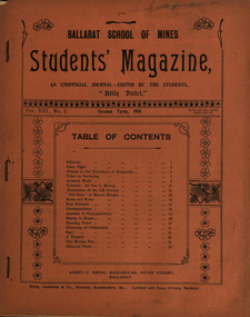 Federation University Historical Collection
Booklet, Berry, Anderson and Co., Printers, Bookbinders, &c, Ballarat School of Mines, Student Magazine, Second Term, 1910, 1910
Table of Contents: Editorial, Open night, Process in ore treatment at Kalgoolie, Notes on surveying, Artesian wells, Concrete: Its use in mining, Description of the I. R. process, "Old Boys" at Mount Morgan, News and notes, Past students, Correspondence, Answers to correspondence, Handy to know, Sporting notes, Discovery of Chloroform, Say!, A tragedy, The Berdan pan, Editorial notes. Ballarat School of Mines Associates. Images.Booklet of 28 pages.table of contents: editorial, open night, process in ore treatment at kalgoolie, notes on surveying, artesian wells, concrete: its use in mining, description of the i. r. process, "old boys" at mount morgan, news and notes, past students, correspondence, answers to correspondence, handy to know, sporting notes, discovery of chloroform, say!, a tragedy, the berdan pan, editorial notes, images. ballarat school of mines associates., alumni: fred j. martell, m. w. bernewitz, angus a. gibson, r. ingram moore, philpot f. brown, w. avery, e. preddergast, godfrey stephen hart, t. s. hart, l. westcott, a. r. booth, w. t. lakeland, lewis westcott, leo m. seward, w. e. eyres, virgil tucker, h. hawkesworth, h. j. saw, h. meadows, fred g. brinsden, c. stephenson, fred treloar, j. peart, e. m. weston, dick galloway, h. b. bennetts, g. r. curry, h. meadows, will watson, don cameron, eric bieske, cliff garrard, lindsay d. cameron, phil brown, w. p. avery, j. foster, j. bickett, f. h. inglis , g. davenport, l. c. courbould, t. lennon, h. wilkins, g. h. reid, c. hesselmann, e. fraser, reg callister, e. c. hursfield, w. baragwanath, c. c. corrie, r. i. moore, j. l. sampson, h. conran, w. geldard. -
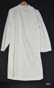 Flagstaff Hill Maritime Museum and Village
Clothing - Surgeon's Gown, early to mid 20th century
This surgeon's gown was donated to Flagstaff Hill Maritime Village by the family of Doctor William Roy Angus, Surgeon and Oculist. It is part of the “W.R. Angus Collection” that includes historical medical equipment, surgical instruments and material once belonging to Dr Edward Ryan and Dr Thomas Francis Ryan, (both of Nhill, Victoria) as well as Dr Angus’ own belongings. The Collection’s history spans the medical practices of the two Doctors Ryan, from 1885-1926 plus that of Dr Angus, up until 1969. ABOUT THE “W.R.ANGUS COLLECTION” Doctor William Roy Angus M.B., B.S., Adel., 1923, F.R.C.S. Edin.,1928 (also known as Dr Roy Angus) was born in Murrumbeena, Victoria in 1901 and lived until 1970. He qualified as a doctor in 1923 at University of Adelaide, was Resident Medical Officer at the Royal Adelaide Hospital in 1924 and for a period was house surgeon to Sir (then Mr.) Henry Simpson Newland. Dr Angus was briefly an Assistant to Dr Riddell of Kapunda, then commenced private practice at Curramulka, Yorke Peninsula, SA, where he was physician, surgeon and chemist. In 1926, he was appointed as new Medical Assistant to Dr Thomas Francis Ryan (T.F. Ryan, or Tom), in Nhill, Victoria, where his experiences included radiology and pharmacy. In 1927 he was Acting House Surgeon in Dr Tom Ryan’s absence. Dr Angus had become engaged to Gladys Forsyth and they decided he further his studies overseas in the UK in 1927. He studied at London University College Hospital and at Edinburgh Royal Infirmary and in 1928, was awarded FRCS (Fellow from the Royal College of Surgeons), Edinburgh. He worked his passage back to Australia as a Ship’s Surgeon on the on the Australian Commonwealth Line’s T.S.S. Largs Bay. Dr Angus married Gladys in 1929, in Ballarat. (They went on to have one son (Graham 1932, born in SA) and two daughters (Helen (died 12/07/1996) and Berenice (Berry), both born at Mira, Nhill ) According to Berry, her mother Gladys made a lot of their clothes. She was very talented and did some lovely embroidery including lingerie for her trousseau and beautifully handmade baby clothes. Dr Angus was a ‘flying doctor’ for the A.I.M. (Australian Inland Ministry) Aerial Medical Service in 1928 . Its first station was in the remote town of Oodnadatta, where Dr Angus was stationed. He was locum tenens there on North-South Railway at 21 Mile Camp. He took up this ‘flying doctor’ position in response to a call from Dr John Flynn; the organisation was later known as the Flying Doctor Service, then the Royal Flying Doctor Service. A lot of his work during this time involved dental surgery also. Between 1928-1932 he was surgeon at the Curramulka Hospital, Yorke Peninsula, South Australia. In 1933 Dr Angus returned to Nhill and purchased a share of the Nelson Street practice and Mira hospital (a 2 bed ward at the Nelson Street Practice) from Dr Les Middleton one of the Middleton Brothers, the current owners of what previously once Dr Tom Ryan’s practice. Dr Tom and his brother had worked as surgeons included eye surgery. Dr Tom Ryan performed many of his operations in the Mira private hospital on his premises. He had been House Surgeon at the Nhill Hospital 1902-1926. Dr Tom Ryan had one of the only two pieces of radiology equipment in Victoria during his practicing years – The Royal Melbourne Hospital had the other one. Over the years Dr Tom Ryan had gradually set up what was effectively a training school for country general-practitioner-surgeons. Each patient was carefully examined, including using the X-ray machine, and any surgery was discussed and planned with Dr Ryan’s assistants several days in advance. Dr Angus gained experience in using the X-ray machine there during his time as assistant to Dr Ryan. When Dr Angus bought into the Nelson Street premises in Nhill he was also appointed as the Nhill Hospital’s Honorary House Surgeon 1933-1938. His practitioner’s plate from his Nhill surgery is now mounted on the doorway to the Port Medical Office at Flagstaff Hill Maritime Village, Warrnambool. When Dr Angus took up practice in the Dr Edward and Dr Tom Ryan’s old premises he obtained their extensive collection of historical medical equipment and materials spanning 1884-1926. A large part of this collection is now on display at the Port Medical Office at Flagstaff Hill Maritime Village in Warrnambool. In 1939 Dr Angus and his family moved to Warrnambool where he purchased “Birchwood,” the 1852 home and medical practice of Dr John Hunter Henderson, at 214 Koroit Street. (This property was sold in1965 to the State Government and is now the site of the Warrnambool Police Station. and an ALDI sore is on the land that was once their tennis court). The Angus family was able to afford gardeners, cooks and maids; their home was a popular place for visiting dignitaries to stay whilst visiting Warrnambool. Dr Angus had his own silk worm farm at home in a Mulberry tree. His young daughter used his centrifuge for spinning the silk. Dr Angus was appointed on a part-time basis as Port Medical Officer (Health Officer) in Warrnambool and held this position until the 1940’s when the government no longer required the service of a Port Medical Officer in Warrnambool; he was thus Warrnambool’s last serving Port Medical Officer. (Masters of immigrant ships arriving in port reported incidents of diseases, illness and death and the Port Medical Officer made a decision on whether the ship required Quarantine and for how long, in this way preventing contagious illness from spreading from new immigrants to the residents already in the colony.) Dr Angus was a member of the Australian Medical Association, for 35 years and surgeon at the Warrnambool Base Hospital 1939-1942, He served as a Surgeon Captain during WWII1942-45, in Ballarat, Victoria, and in Bonegilla, N.S.W., completing his service just before the end of the war due to suffering from a heart attack. During his convalescence he carved an intricate and ‘most artistic’ chess set from the material that dentures were made from. He then studied ophthalmology at the Royal Melbourne Eye and Ear Hospital and created cosmetically superior artificial eyes by pioneering using the intrascleral cartilage. Angus received accolades from the Ophthalmological Society of Australasia for this work. He returned to Warrnambool to commence practice as an ophthalmologist, pioneering in artificial eye improvements. He was Honorary Consultant Ophthalmologist to Warrnambool Base Hospital for 31 years. He made monthly visits to Portland as a visiting surgeon, to perform eye surgery. He represented the Victorian South-West subdivision of the Australian Medical Association as its secretary between 1949 and 1956 and as chairman from 1956 to 1958. In 1968 Dr Angus was elected member of Spain’s Barraquer Institute of Barcelona after his research work in Intrasclearal cartilage grafting, becoming one of the few Australian ophthalmologists to receive this honour, and in the following year presented his final paper on Living Intrasclearal Cartilage Implants at the Inaugural Meeting of the Australian College of Ophthalmologists in Melbourne In his personal life Dr Angus was a Presbyterian and treated Sunday as a Sabbath, a day of rest. He would visit 3 or 4 country patients on a Sunday, taking his children along ‘for the ride’ and to visit with him. Sunday evenings he would play the pianola and sing Scottish songs to his family. One of Dr Angus’ patients was Margaret MacKenzie, author of a book on local shipwrecks that she’d seen as an eye witness from the late 1880’s in Peterborough, Victoria. In the early 1950’s Dr Angus, painted a picture of a shipwreck for the cover jacket of Margaret’s book, Shipwrecks and More Shipwrecks. She was blind in later life and her daughter wrote the actual book for her. Dr Angus and his wife Gladys were very involved in Warrnambool’s society with a strong interest in civic affairs. He had an interest in people and the community They were both involved in the creation of Flagstaff Hill, including the layout of the gardens. After his death (28th March 1970) his family requested his practitioner’s plate, medical instruments and some personal belongings be displayed in the Port Medical Office surgery at Flagstaff Hill Maritime Village, and be called the “W. R. Angus Collection”. The W.R. Angus Collection is significant for still being located at the site it is connected with, Doctor Angus being the last Port Medical Officer in Warrnambool. The collection of medical instruments and other equipment is culturally significant, being an historical example of medicine from late 19th to mid-20th century. Dr Angus assisted Dr Tom Ryan, a pioneer in the use of X-rays and in ocular surgery. White, heavy duty cotton surgeon's gown, part of the W.R. Angus Collection. Gown hasshoulder button fastening. Both cuffs are well worn and fraying, also 'L' shaped tear on front right has been machine repaired. Remnants of label on inside collar with name "ANGUS". Also Maker's label, "PUKKA", made in Melbourne.Remnants of ‘ANGUS” on inside collar. Maker’s label “It’s a PUKKA” and “PUKKA DRILLS / TAILORED BY PERO MELBOURNE / UNSHRINKABLE” Label has "SIZE 42" flagstaff hill, warrnambool, shipwrecked coast, flagstaff hill maritime museum, maritime museum, shipwreck coast, flagstaff hill maritime village, great ocean road, dr w r angus, dr ryan, surgical instrument, t.s.s. largs bay, warrnambool base hospital, nhill base hospital, mira hospital, flying doctor, surgeon's gown, surgical clothing, pukka, pukka drills, tailored by pero melbourne, melbourne taylor -
Federation University Historical Collection
Booklet - Booklet - Song Book, Macdonald Printers, School of Mines (and Junior Technical School) Ballarat Students' Dirgerie, c1915, 1924, c1915
Ballarat Junior Technical School was a division of the Ballarat School of Mines, Opening in the ground of the Dana Street Primary School in 1913, it moved into a custom built double storey building on the Ballarat School of Mines Grounds in 1921. Booklet contains songs and chants written by students. A couple are sung to the tune of well known songs - "He's a Jolly Good Fellow" and "There is a Tavern in the Town".3 x Blue soft covered book of songs including the Ballarat School of Mines yell, the Ballarat Junior Technical School Yell, and other songs. .1 J R Pound on front cover. Page numbers beside songs indicate music used. .2 H. Jolly 1915 on front cover .3 E J Tippett 1924 on front cover students' dirgerie, ballarat school of mines, school song, school yell, ballarat junior technical school, harold holly, s m b dirge, ye caverne song, a way we have at the s m b, mary had a william goat, yap yap yap, s m b yell, junior tech yell, ye school yells -
Federation University Historical Collection
Booklet - Booklet - Prospectus, J. Kemp, Melbourne Junior Technical School, Prospectus, 1912, 1912
Used at Ballarat School of Mines and Industries. The Melbourne Junior Technical School opened in 1912. It was a School for Junior Technical Work in Science, Art and Trade. This Prospectus gives information about the aim of school, courses of study, scholarships, standards of admission, holidays, evening classes, regulations, rules, sports, staff, advice to students and parents, railway and tram fares and syllabuses of work. As this was the first year of the School, Staff were introduced and their previous positions were detailed. Head Master was Mr P McCormick who had been head of the Junior Technical School at the Working Men's College. The Senior Master was Mr Bruce who had also been at the Working Men's College. Mr Hauser was selected for his position at the Education Department and would be the English Master. Mr Gilmore was the Art Master and had been at the Working Men's College. Mr Lewis was appointed Mathematical Master. He was a graduate from Melbourne University. The Science Master was Mr R A White and was an instructor at the Junior Technical School, Bendigo School of Mines and Industries. As well as these members of staff there was a competent staff of assistants.Grey soft covered booklet with information about admissions, aim of the school, courses of study, enrolment, fees, scholarships, staff, syllabuses and subjectsmelbourne, melbourne junior technical school, prospectus, 1912, science, art, trades, scholarships, evening classes, syllabuses, working men's college, bendigo school of mines and industries, head master, p mccormick, senior master, mr bruce, english master, mr hauser, education department, art master, mr gilmore, mathematical master, mr lewis, melbourne university, r a white, bendigo junior technical school -
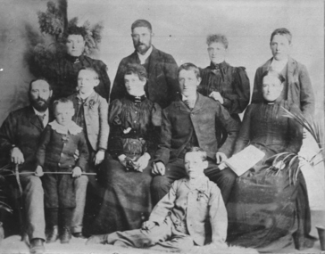 Federation University Historical Collection
Photograph - Photograph and Documents, Anne Beggs Sunter, Latta/Downing Family, Mount Helen
The Federation University Mt Helen Campus was once the farm of John Latta and his wife Elizabeth Ann Dean. The couple married in 1867 and had three children at the time of John Latta's death (Elizabeth Ann b.1870; Mary b.1873; John b.1875). Elizabeth later married George Downing, and had another six children. The house was situated in the vicinity of the current Administration and Caro Conference Centre buildings, surrounded by an orchard, and a well under the current Albert Coates Building (Union Building). The land was purchased by the Ballarat School of Mines for their tertiary division from the Stapleton family.Various items relating to the Federation University Mount Helen Campus, and the early settlers on the land, the Latta Family. .1) Parish Plan, including E. Latta, M. Fiscalini, R. Wynne, R. Nixon, J.U. Smith, J. Davis .2) Part of a 1930s ordinance map showing Ballarat, Buninyong and Greenhill .3) Contour Map with the first two Mt Helen Campus buildings included. .4) Drawing a a proposed campus plan .5) Latta Family negativemount helen campus, latta family, greenhill, e. latta, m. fiscalini, r. wynne, r. nixon, j.u. smith, j. davis, parish plan, john latta, elizabeth latta, george downing, elezabeth downing, green hill, pontresina, abraham baxter, g. dean, market gardens, jim downing, bob thornton, j. hateley, martin fanning, toll keeper, anne beggs sunter -
 Australian Commando Association - Victoria
Framed photograph, The Krait on Sydney Harbour, Photo taken in 1964
Cdo Assoc Victoria presented it to Exmouth Heavy AA Assoc. This was because the Krait left Exmouth on the successful Opn Jaywick raid on Japanese occupied Singapore Harbour in 1943. Exmouth Heavy AAA has now disbanded and daughter of a foundation member donated it back to the (post-WW2) Vic Cdo Assoc in July 2012.The former Japanese fishing boat, as MV Krait left Exmouth on the successful Opn Jaywick raid on Japanese occupied Singapore harbour in 1943. The vessel was partly restored, and motored into Sydney harbour in 1964 with former Z Special members on board, including the Jaywick operatives Berryman, Carse, Jones and Young. Black wooden frame with gold-painted border. Photo has large white borders. Black and white photograph of the WW2 Krait of Operation Jaywick fame, on Sydney Harbour in 1964 with crew members and four former Jaywick operatives on board - Berryman, Carse, Jones and Young. Legend: October 1972 Presented to EXMOUTH HEAVY ANTI AIRCRAFT ASSOCIATION by the VICTORIAN COMMANDO ASSOCIATION. Four original crew members standing at forward well deck 1964. L to R Moss Berryman, Horrie Young, Ted Carse & Joe Jones. Brass plate on frame: "KRAIT." On back: "Barilyn Images 59 85 4666."japanese fishing boat mv krait exmouth operation jaywick singapore harbour z special berryman carse jones young. -
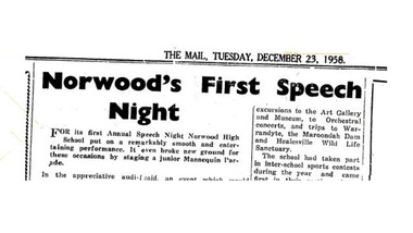 Ringwood and District Historical Society
Newspaper - Clippings, Ringwood Mail, First Speech Night - Norwood High School, Ringwood, Victoria, 1958
Ringwood Mail newspaper article clipped from pages 9 and 14, 23 December, 1958.Norwood's First Speech Night FOR its first Annual Speech Night Norwood High School put on a remarkably smooth and entertaining performance. It even broke new ground for these occasions by staging a junior Mannequin Parade. In the appreciative audience were the Mayor and Mayoress of Ringwood (Cr. and Mrs. R. 0. Spencer), Cr.and Mrs. Peter Vergers, Cr.and Mrs. Doug Baxter, Cr.and Mrs. Ben Hubbard, and Mr. George Ormandy (Head Master of Ringwood High School) and Mrs. Ormandy. After the singing of the Norwood High School Song,'Fidelis', the Mayor, as Chairman, gave high praise to the school for its 'mighty effort on its first Speech Night.' It was an historic night, he said, an event which would live in the minds of the boys and girls of the school for as long as they lived. Education was a live issue today, the Mayor said, and it was as well to reflect on what the teaching staff of a school was asked to do. They were asked to teach the children how to play their part in life, to make decent men and women of them. And if the children were a future disappointment to their parents the Head Master and the staff could not be blamed. On behalf of the Council and citizens of Ringwood, the Mayor offered congratulations and good wishes for a happy Christmas. In his report the Head Master (Mr. J. A. Gibson, B.A.) said the school colours of purple and gold had been appropriately chosen because of the golden wattle and purple sarsaparilla which rioted through the district. The badge design was a transition of Nowood to Northward, a symbolic representation of the magnetic compass which formed the central motif of the badge. The fact that the compass is used by travellers as a reliable guide gave the school the motto 'Fidelis' which combined the ideas of faithfulness trustworthiness and dependability. The word was easy to remember and to say, and its meaning set a worthy ideal which the boys and girls of the school could strive to attain. For House names native words had been chosen and they were associated with features of the district. The names Kalinda, Maroondah, Mullum and Yarra had already acquired a special significance for everyone associated -with the school. School traditions were also being established, the report went on, by the holding of annual swimming and athletic meetings and the awarding of prizes, and the school had been helped here by the generosity of certain good people of the community who had presented trophies. In the field of inter-house activities the Couche family had presented to the school the Couche Cup for Swimming Contests, and the Warrandyte cup for aggregate points earned in all sports; Mr. Avison had presented the Norwood Cup. for Athletics Contests, and Mr. and Mrs. Jack Godbehear the Rosebank Shield for award to the House gaining the highest aggregate score each year. Members of the Mackinlay family had perpetuated the name of the early owner of the property on which the school is built by donating a sum of money, the interest of which would provide the William and Elizabeth Mackinlay Prize each year for the Dux of Norwood High School. ATHLETIC SUCCESS The gross enrolment of 117, included 52 boys and 65 girls, who were divided into three forms of approx equal ability. The curriculum had been broadened to include excursions to the Art Gallery and Museum, to Orchestral concerts, and trips to Warrandyte, the Maroondah Dam and Healesville Wild Life Sanctuary. The school had taken part in inter-school sports contests during the year and came first in their section of the Swimming Contests held at Olympic Pool, also gaining second place at the Athletic Meeting at Olympic Park late in the year. A Social Service League had been formed in the school and had raised £36/7/3. This had been distributed to the Anti-Cancer Campaign, the Lord Mayor's Hospital Appeal, and Yooralla Crippled Children's Appeal. A Parents and Citizens Association had also been formed which had already raised more than £90 towards school funds. Mr. Gibson expressed the school's appreciation to the Head Master, staff and pupils of Boronia High School where Norwood pupils had been guests, and hoped that Norwood would be able to look after Mitcham High School as well in the coming year. After an informative explanation of the 'Importance and Responsibilities of a High School Advisory Council given by Inspector of Schools, Mr. H. W. Hopkins, B.A., the big moment of the evening arrived—the presentation of prizes and certificates by the Hon. J. W. Manson, MLA. Mr. Manson said the purpose of a school was twofold. It was to teach the children to fend for themselves and to live with one another. He congratulated Norwood High on its good start for the year and also those who didn't win prizes because, he said, they had learnt the most important lesson of all — not to win but to keep on trying. Second half of the program was purely entertainment. The School Drama Club presented a Christmas Nativity tableau and an adaptation of Charles Dickens' 'Christmas Carol' with considerable talent. The unique Dress Parade, conducted on the usual professional lines with a running commentary, was both amusing in its sophistication and delightful for the youthful charm of the mannequins and the excellence of the garments displayed. Attractive winter and summer school uniforms were displayed by boys and girls and featured the purple and gold colouring of the school. The girls' summer uniforms were fresh and cool looking with narrow lavender and white stripes. Gold Cesarine sports frocks were distinguished by a purple cord sash. Garments were made by girls in the Needlework Classes and reflected the greatest credit on both pupils and teachers. Cooking aprons, skirts, frocks and knitted sweaters and cardigans showed a wide variety and charm and the school uniforms were practical and smart. There was a bracket of rollicking folk dancing and a Making Music Interlude in which a group of boys and girls, in full hillbilly rig put on a turn with home-made instruments, penny whistles and their own fresh young voices. Teamwork was very good and the whole thing most amusing. Under the direction of Mr.J. A. Collins, the School choir sang delightfully; the traditional 'Greensleeves' and 'Gaudeums Igitur' being particularly effective. PRESENTATION PRIZES FORM 1A PASS CERTIFICATES — Margaret Forder, Noala Fullarton,Karen Gill, Jeanette Hamilton, Maureen Ing, Phyllis Kellar, Marie Knee, Norma Leslie, Mary Mackay, Valerie Quaife, Beverley Rimmer, Elizabeth Stubbs, Heather Trout, Gail Waugh, Brigitte Wieneroider, Jacqueline Wilson, Jeffrey Barnes, Stuart Dickson, Donald Duff, Brian Fitzgrald, Patrick Ford, Ian .Holt, Robert Jenkins, Allan Meyland, Ross Perkins, David Pullen, Denis Wise, John Wright. HONOUR CERTIFICATES; Lois Dewar, 89; Pauline Harmer 86.9, Brian Horswell 87.2. PASS CERTIFICATE and MOST IMPROVED: Willy Hoogstraat. HONOUR CERTIFICATE and DUX: Anne Luscombe, 94.9. FORM IB PASS CERTIFICATES: Faye Alsop, Helen Ashton, Joan Bedford, Carole Bonnett, Hazle Collins, Eileen Gunn, Gloria Lander, Meryn Longmire, Dianne Mclntyre, Geraldine McWilliam, Leslie Mahoney, Dawn Marley-, Judith Miller, Ann Morgan, Lucia Pruis, Dianne Whitehead, Jeffrey Aus, Peter Buckthorpe, Donald Falkingham, Brian Girvan, Nicholas Lobb, Graham Prime, Keith Purdie, Ronald Ryan, Colin Standfield, Kerry Stuart, Michael Toppin, Ian Weist, Terrence West, James Wilson. HONOLTR CERTIFICATES: Anne Couche 85.2; Susan Rule, 93.1; Dianne Thompson 92.1. PASS CERTIFICATE and MOST IMPROVED: Anne Bottomley. HONOUR CERTIFICATE and DUX: Arno Haemmerlea. FORM 1C PASS CERTIFICATES: Caroline Andrew, Ann Blower, Dianne Brown, Glenda Farrall, Judith Gibson, Jane Godbehear, Deidre Harding, Helen Morris, Margaret Patterson, Beverley Vergers, Heike Wenzel, Naomi Willshire. Beverley Wilson, Linda Woolan, Geoffrey David, Rowan Don, Timothy Donovan, Anthony Johnston, Michael Lavey, Frank Noble, Michael Parks, Graham Rogers, Gordon Stark, Angus Stark, David Williams. HONOUR, CERTIFICATES: Jennifer Coombs 87.1; Janice Cooke, 85.3; Merlyn Robertson 89.4; Richard Bell, 88.5; Peter Van Den Heuvel, 92.9; John Kerr, 89.3. PASS CERTIFICATE and MOST IMPROVED: Phillip Brown. HONOUR CERTTFICATE and DUX; Helena Lobb. ART PRIZE: Merlyn Robertson, 1C. NEEDLEWORK PRIZE: Judith Gibson, 1C. WILLIAM and ELIZABETH MACKINLAY PRIZE for Dux of the School: Anne Luscombe, 34.8. ATHLETICS CHAMPIONS. Norma Leslie (Mullum) under 13, girls. Dianne Whitehead (Yarra), 13 yrs and over girls, Don Falkingham (Kalinda), under 13, yrs, boys, Denis Wise (Maroondah), 13 years and over. HOUSE AWARDS Couche Cup for House Swimming Competition: Maroondah. Norwood Cup for House Athletics; Mullum. Warrandyte Cup for House Sport: Yarra. Rosebank Shield, for total House Points scored during year: Mullum. -
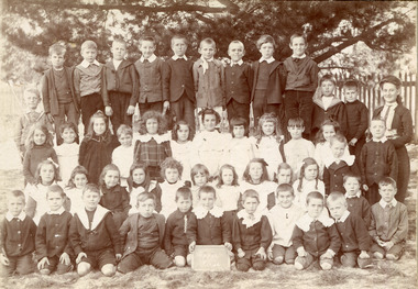 City of Moorabbin Historical Society (Operating the Box Cottage Museum)
Photograph, 2 x Black & White Beaumaris State School , Miss Reynolds 1906, 07, 1906, 1907
Teacher Miss Reynolds is shown with her 'Upper Class' in 1906 and '2nd Class' in 1907. West Beaumaris School No 84 in Charman Road Stephen Charman, 1821-1906 a market gardener, donated land for the first Methodist Chapel, Cemetery and School in Charman Rd Cheltenham 1855. The enrolment was 36 pupils with Mr Frederick Meeres as Teacher. 1863 the school is called Beaumaris Common School No 84 with 70 pupils and Walter Meeres as Teacher. 1869 another 2 acres in Charman Road were granted by the Education Board and brick building built . 1872 State School 84 Beaumaris was increasing enrollments and 1878 a new brick school was built to accommodate 174 pupils and the name changed to Cheltenham State School No.84 1894 Mentone State School No.2950 amalgamated with Cheltenham SS No.84. 1910 the buildings were in disrepair, overcrowding was increasing and renovations were made 1912 with further additions in 1925 and 1937. Post WW11 extra prefabricated Classrooms were added as enrollment increased to 1038 in 1955.. Cheltenham East State School 4754 was opened as housing development spread over the City of Moorabbin . ( J Larson Sandringham HS)1855 Stephen Charman donated land to the Methodist Church so that a School could be established to educate the children of the early settler market gardeners and farmers in the Cheltenham area . Education was valued by the general community and as well as schools they established mechanics Institutes and Libraries in Moorabbin Shire. Cheltenham State School No. 84 was among the first schools in Melbourne.2 x Black & White Photographs of Beaumaris State School pupils with Miss Reynolds in 1906 and 1907Hand written ; Warburton, B. Wooff, R. Whelan, Miss Reynoldscity of moorabbin, county of bourke, moorabbin roads board, parish of moorabbin, shire of moorabbin, henry dendy's special survey 1841, were j.b.; bent thomas, o'shannassy john, king richard, charman stephen, highett william, ormond francis, maynard dennis, cheltenham state school no.84, methodist chapel cheltenham, methodist school cheltenham, beaumaris west state school, meeres frederick, meeres walter, education, early settlers, -
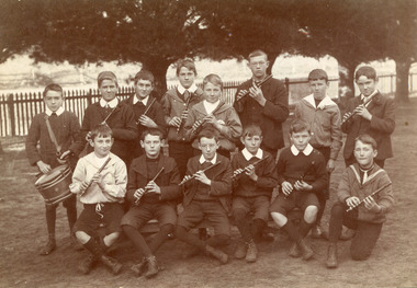 City of Moorabbin Historical Society (Operating the Box Cottage Museum)
Photograph,Black & White Cheltenham State School Fife & Drum Band c1908, c1908
1855 Stephen Charman donated land to the Methodist Church so that a School could be established to educate the children of the early settler market gardeners and farmers in the Cheltenham area . Education was valued by the general community and as well as schools they established mechanics Institutes and Libraries in Moorabbin Shire. Cheltenham State School No. 84 was among the first schools in Melbourne. Stephen Charman, 1821-1906 a market gardener, donated land for the first Methodist Chapel, Cemetery and School in Charman Rd Cheltenham 1855. The enrolment was 36 pupils with Mr Frederick Meeres as Teacher. 1863 the school is called Beaumaris Common School No 84 with 70 pupils and Walter Meeres as Teacher. 1869 another 2 acres in Charman Road were granted by the Education Board and brick building built . 1872 State School 84 Beaumaris was increasing enrollments and 1878 a new brick school was built to accommodate 174 pupils and the name changed to Cheltenham State School No.84 1894 Mentone State School No.2950 amalgamated with Cheltenham SS No.84. 1910 the buildings were in disrepair, overcrowding was increasing and renovations were made 1912 with further additions in 1925 and 1937. Post WW11 extra prefabricated Classrooms were added as enrollment increased to 1038 in 1955.. Cheltenham East State School 4754 was opened as housing development spread over the City of Moorabbin . (J.Larson Sandringham HS) Probably due to the Scottish heritage of many early settlers the Fife & Drum Band was established at the West Beaumaris (Cheltenham) State School . The Fife is similar to the piccolo, and usually made of wood, consisting of a tube with 6 finger holes and an embouchure hole that produces sound when blown across.The fife was used in folk music traditions to accompany dancing by all social classes. Also in the Military where drums accompanied the fife and originally these 'boy soldier ' bands were used to signal manouevres in the field for the infantry. Later Fife & Drum bands were used for marching bands in schools and community groups, 1855 Stephen Charman donated land to the Methodist Church so that a School could be established to educate the children of the early settler market gardeners and farmers in the Cheltenham area . Education was valued by the general community and as well as schools they established mechanics Institutes and Libraries in Moorabbin Shire. Cheltenham State School No. 84 was among the first schools in Melbourne.Black & White photograph of pupils at West Beaumaris (Cheltenham) State School No.84 in the boy's Fife and Drum Band c 1908Back Handwritten Mrs Whelan / Beaumariswhelan r, marriott geoff, meeres frederick, cheltenham state school no.84, education, keys robert, holloway josiah, king brothers, smith j l; smith mary ann, stanley helen, chaff cutter, horse drawn carts, toll gates brighton, motor cars 1900, steam engines, early settlers, bentleigh, parish of moorabbin, city of moorabbin, county of bourke, moorabbin roads board, shire of moorabbin, henry dendy's special survey 1841, were j.b.; bent thomas, o'shannassy john, king richard, charman stephen, highett william, ormond francis, maynard dennis, market gardeners, vineyards, orchards -
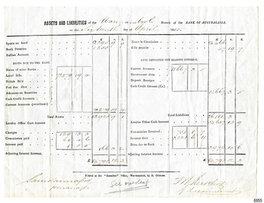 Flagstaff Hill Maritime Museum and Village
Document - Financial report, Samuel Hannaford, Assets and Liabilities, 16-04-1855
... , the 'Examiner', by the well-known local businessman, R. Osborne (Richard... newspaper, the 'Examiner', by the well-known local businessman, R ...This financial report was written by the Manager of Warrnambool's branch of the Bank of Australasia, Samuel Hannaford. The branch was established in 1854 and this report was written on April 16th 1855. The report on the form's front shows the Bank's Assets and Liabilities at that date and the handwritten summary on the back includes other figures including the Net Profit. The form was printed at the printing office of the local newspaper, the 'Examiner', by the well-known local businessman, R. Osborne (Richard). The Bank of Australasia was incorporated by the Royal Charter of England in March 1834. The bank began in Australia on 14th December 1835, opening in Sydney. The Acting Superintendent of the bank at that time was David Charters McArthur. He was Superintendent from 1867-to 1876. The Melbourne branch opened on 28th August 1838 in a two-roomed brick cottage on the north side of Little Collins Street, where two huge mastiff dogs were used at night to guard the bank. The government also provided an armed military sentinel. Due to the bank's rapid growth, a new building for the Melbourne branch was opened in 1840 at 75 Collins Street West. By 1879 the bank had been upgraded to a magnificent two-storey building on the corners of Collins and Queens Streets, with the entry on Collins Street. In 1951 the Bank of Australasia amalgamated with the Union Bank to form Australia and New Zealand Bank, now known as the ANZ. Then in 1970, the ANZ merged with both the ES&A and the London Bank of Australia to form the ANZ Banking Group Limited. The ANZ Banking Group Ltd kindly donated a variety of historic items from the Bank of Australasia. BANK of AUSTRALASIA, WARRNAMBOOL – In 1854 Warrnambool had two banks, the Union Bank and the Bank of Australasia. Later, completely different bank businesses opened; in 1867 the National Bank of Australasia, then in 1875 the Colonial Bank of Australasia. The original Warrnambool branch of the Bank of Australasia was established in July 1854, and operated from a leased cottage on Merri Street, close to Liebig Street. The bank later bought a stone building previously erected by drapers Cramond & Dickson on the corner of Timor and Gibson Streets. Samuel Hannaford was a teller and then Manager at the Warrnambool branch from 1855 to 1856 and the Warrnambool Council chose that bank for its dealings during 1856-57. In 1859 Roberts & Co. was awarded the contract to build the new Bank of Australasia branch for the sum of £3,000. The land was on a sand hill on the northeast corner of Timor and Kepler Streets and had been bought in 1855 from investor James Cust. The new building opened on May 21, 1860. The bank continued to operate there until 1951 when it merged with the Union Bank to form the ANZ Bank, which continued operating from its Liebig Street building. Warrnambool City Council purchased the former Bank of Australasia building in 1971 and renovated it, then on 3rd December 1973 it was officially opened as the Art Gallery by Cr. Harold Stephenson and Gallery Director John Welsh. The Gallery transferred to the purpose-built building in Liebig Street in 1986 and the old bank building is now the Gallery club. Staff at the Bank of Australasia in Warrnambool included the following men but others were also involved: Samuel Hannaford, Teller then Manager from 1855-1856; W H Palmer, Manager from January 1857 until November 1869 when the Teller Basil Spence was promoted to Manager; H B Chomley, Manager from April 1873 and still there in 1886; A Butt, Manager in 1895-1904; J R McCleary Accountant and Acting Manager for 12 months, until 1900; A Kirk, Manager 1904; J Moore, staff until his transfer to Bendigo in December 1908; J S Bath was Manager until 1915; C C Cox, Manager until April 1923; Richard C Stanley, Manager 1923 to April 1928. This financial record for Warrnambool's branch of the Bank of Australasia has great historical significance as it is likely to be fhe first statement of Assets and Liabilities of the Bank's branch, which was established in Warrnambool in 1854. The report is signed by the Bank's first manager, Samuel Hannaford. The record's form is significant for its connection with the printer's office, the 'Examiner' which was an early local enterprise established in 1851. The printer, Richard Osborne, was a very involved community member and his name is well known even today. One of his publications, The History of Warrnambool, is a well-used local history reference. The report is significant for its association with the Bank of Australasia in Warrnambool, the first bank in Warrnambool. The bank continued to operate until its merger in 1951 when it became the ANZ Bank, which is still in operation today. The Bank was an integral part of the establishment and growth of commerce in Colonial Warrnambool and throughout Australia.Report on a pre-printed form, white paper and black ink. Completed report of the Bank of Australasia, Warrnambool Branch, of the Bank's Assets and Liabilities as of 16th April 1855. On the reverse is a column of handwritten figures with a heading, For the half year to 16th April 1855. Signatures are on the front, including Samuel Hannaford, Manager. The form was printed at the 'Examiner' office in Warrnambool by R. Osborne."Warrnambool 16th April 1855", Total Assets "£83,.925.9.1.", Total Liabilities "£26,181.3.0" "For the half year to 16th April 1855" "Drafts on London" "do Drafts on Branches" "British Bills Remitted" "Net Profit" of "£3,106.12.4", "Average Capital Employed"flagstaff hill, warrnambool, flagstaff hill maritime museum, maritime museum, commerce, banking, bank of australasia, david charters mcarthur, assets and liabilities, financial report, samuel hannaford, 1855, financial statement, examiner, richard osborne, bank manager -
Bendigo Historical Society Inc.
Document - ROYAL PRINCESS THEATRE COLLECTION: VICTORIAN SYMPHONY ORCHESTRA, c1954
Victorian Symphony Orchestra, Royal Princess Theatre, Bendigo. Direction: Australian Broadcasting Commission. Conducted by Juan Jose Castro. Soloist: Donald Westlake (Clarinet). This series of concerts is arranged by the Australian Broadcasting Commission in Conjunction with the Government of Victoria. Royal Princess Theatre, Bendigo, Thur., 12 Nov. 8 p.m. Programme. Juan Jose Castro. Since he left Australia last November on six months' leave, Mr. Castro has been conducting and holidaying in Europe, and with his wife re-visited South America for the first time in eighteen months. In Italy he corrected the publisher's proofs of his opera, 'Proserpina and the Stranger,' which won the Verdi Prize award by La Scala I 1952, and is now . . . Analytical Notes . . . Personnel of the Orchestra. Conductor: Juan Jose Castro. Associate Conductor: Clive Douglass. First Violins: Bertha Jorgensen (leader), Harry Hutchins (Assistant Leader), Frank Schieblich, Norman Deerson, Paul O'Brien, William Glassford, Ruth Michael, Alex Burlakov. Second Violins: Hyman Lenzer, Robert Pattison, George Paton, Donald Weekes, Marie Bull, Harvey Davis. Violas: Coin Kerr, Mischa Kogan, Marion Ogilvie, Winifred Roberts. Cellos: Don Howley, Henri Touzeau, Valerie Awburn, Ezio Neri. Basses: Guill Fraillon, Frank Cerbasi, Samuel Shiffron. Flutes: Richard Chugg, Leslie Barklamb, Audrey Walklate. Oboes: Jiri Tancibudek, David Woolley. Clarinets: Thomas White, Isobel Carter. Bassoons: Roy White, Gordon Miller, Gordon Grieve, Graham Bickford. Trumpets: Mervyn Simpson, John Geary. Trombones: Stanley Code, John McGade. Bass Trombone: Harold Willis. Tuba: Ron Stevens. Tympani: Gordon Craig. Percussion: Ernest Lighton, Bert Crawford. Harp: Adrian Bendall. Australian Broadcasting Commission; R J F Boyer M.A., Chairman. E R Dawes, Vice-Chairman. Sir John Medley, KT., D.C.L., L.L.D., M.A. P Vanthoff, M.V.O. The Hon. Dame Enid Lyons, G.B.E. J C Stewart, M W O'Donnell, B.E.C. Charles Moses, General Manager. T S Duckmanton, A./Manager for Victoria. Dorrie O'Neil, Concert Manager for Victoria. Photos: Juan Jose Castro, Donald Westlake. Advertisements: Notice to subscribers; Annual General Meeting for Albury, Bendigo, Shepparton, for 1954. TAA serves the Nation. Country Club, Tailored by Buckwalter. GMH, The whole story from A to Z. Carnegie's, 106 Elizabeth St. b/ Victorian Symphony Orchestra, Conducted by Juan Jose Castro, Soloist: Joan Jones (Contralto). This series of concerts is arranged by the Australian Broadcasting Commission in conjunction with the Government of Victoria. Town Hall, Swan Hill. Programme. Juan Jose Castro, (first 4 paragraphs reads as per 4280a). At the end of his 1953 Australian season, Mr. Castro is in conduct concerts in Italy, Paris and London, as well as being re-engaged for Yugo-Slavia, which he visited for the second time last December. With his wife he had the thrill of experiencing . . . Analytical Notes. Personnel of the Orchestra. Conductor: Juan Jose Castro. Associate Conductor: Clive Douglas. First Violins: Bertha Jorgensen (Leader), Harry Hutchins (Assistant Leader), Frank Schieblich, Norman Deerson, Paul O'Brien, William Glasford, Ruth Michael, Alex Burlakov. Second Violins: Hyman Lenzer, Reginald Bradley, Robert Pattison, Donald Weekes, Marie Bull, Harvey Davis Violas: Colin Kerr, Mischa Kogan, Marion Ogilvie, Winifred Roberts. Cellos: Don Howley, Henri Touzeau, Valerie Awburn, Ezio Neri. Basses: Guill Fraillon, Frank Cerbasi, Milinor Morton. Flutes: Richard Chugg, Leslie Barklamb, Audrey Walklate. Oboes: Jiri Tancibudek, David Woolley. Clarinets: Thomas White, Isobel Carter. Bassoons: Thomas Wightman, Noel Hunt. Trumpets: Mervyn Simpson, Standish Roberts. Trombones: Stanley Code, John McGlade. Bass Trombone: Harold Willis, Tuba: Ron Stevens. Tympani: Gordon Craig. Percussion: Ernest Lighton, Bert Crawford. Harp: Adrian Bendall. Australian Broadcasting Commission; committee members. Photos: Juan Jose Castro, Cover. Joan Jones, page 4. Advertisements: QANTAS and B O A C , Qantas Empire Airways LTD. (incorporated I Queensland) in parallel with BRITISH OVERSEAS AIRWAYS CORPORATION. Coming orchestra dates for: Shepparton & Bendigo. Country Club, Tailored by Buckwalter. Carnegie's 'The House of Pianos'.program, theatre, orchestra, a/ victorian symphony orchestra, royal princess theatre, bendigo. direction: australian broadcasting commission. conducted by juan jose castro. soloist: donald westlake (clarinet). this series of concerts is arranged by the australian broadcasting commission in conjunction with the government of victoria. royal princess theatre, bendigo, thur., 12 nov. 8 p.m. programme. juan jose castro. which won the verdi prize award by la scala i 1952, and is now . . . analytical notes . . . orchestra. conductor: juan jose castro. associate conductor: clive douglass. first violins: bertha jorgensen (leader), harry hutchins (assistant leader), frank schieblich, norman deerson, paul o'brien, william glassford, ruth michael, alex burlakov. second violins: hyman lenzer, robert pattison, george paton, donald weekes, marie bull, harvey davis. violas: coin kerr, mischa kogan, marion ogilvie, winifred roberts. cellos: don howley, henri touzeau, valerie awburn, ezio neri. basses: guill fraillon, frank cerbasi, samuel shiffron. flutes: richard chugg, leslie barklamb, audrey walklate. oboes: jiri tancibudek, david woolley. clarinets: thomas white, isobel carter. bassoons: roy white, gordon miller, gordon grieve, graham bickford. trumpets: mervyn simpson, john geary. trombones: stanley code, john mcgade. bass trombone: harold willis. tuba: ron stevens. tympani: gordon craig. percussion: ernest lighton, bert crawford. harp: adrian bendall. australian broadcasting commission; r j f boyer m.a., chairman. e r dawes, vice-chairman. sir john medley, kt., d.c.l., l.l.d., m.a. p vanthoff, m.v.o. the hon. dame enid lyons, g.b.e. j c stewart, m w o'donnell, b.e.c. charles moses, general manager. t s duckmanton, a./manager for victoria. dorrie o'neil, concert manager for victoria. photos: juan jose castro, donald westlake. bendigo, 1954. taa. buckwalter. gmh, the whole story from a to z. carnegie's, 106 elizabeth st. b/ soloist: joan jones (contralto). this series of concerts is arranged by the australian broadcasting commission. town hall. juan jose castro. 1953 australian season, analytical notes. personnel of the orchestra. first violins: second violins: reginald bradley. violas: cellos: don howley, henri touzeau, valerie awburn, ezio neri. basses: guill fraillon, frank cerbasi, milinor morton. flutes:. oboes:. clarinets:, bassoons: thomas wightman, noel hunt. trumpets: standish roberts. trombones:. bass trombone:, tuba:. tympani:. percussion:. harp:. photos: juan jose castro. joan jones, qantas and b o a c , qantas empire airways ltd. british overseas airways corporation: bendigo. country club, buckwalter. carnegie's a/ victorian symphony orchestra, royal princess theatre, bendigo. direction: australian broadcasting commission. conducted by juan jose castro. soloist: donald westlake (clarinet). australian broadcasting commission government of victoria., thur., 12 nov. 8 p.m. juan jose castro. mr. castro has been conducting and holidaying in europe, and with his wife re-visited south america in italy he corrected the publisher's proofs of his opera, 'proserpina and the stranger, ' verdi prize award by la scala i 1952, .associate conductor: clive douglass. first violins: bertha jorgensen (leader), harry hutchins (assistant leader), frank schieblich, norman deerson, paul o'brien, william glassford, ruth michael, alex burlakov. second violins: hyman lenzer, robert pattison, george paton, donald weekes, marie bull, harvey davis. violas: coin kerr, mischa kogan, marion ogilvie, winifred roberts. cellos: don howley, henri touzeau, valerie awburn, ezio neri. basses: guill fraillon, frank cerbasi, samuel shiffron. flutes: richard chugg, leslie barklamb, audrey walklate. oboes: jiri tancibudek, david woolley. clarinets: thomas white, isobel carter. bassoons: roy white, gordon miller, gordon grieve, graham bickford. trumpets: mervyn simpson, john geary. trombones: stanley code, john mcgade. bass trombone: harold willis. tuba: ron stevens. tympani: gordon craig. percussion: ernest lighton, bert crawford. harp: adrian bendall. abccommittee: r j f boyer m.a., chairman. e r dawes, vice-chairman. sir john medley, kt., d.c.l., l.l.d., m.a. p vanthoff, m.v.o. the hon. dame enid lyons, g.b.e. j c stewart, m w o'donnell, b.e.c. charles moses, general manager. t s duckmanton, a./manager for victoria. dorrie o'neil, concert manager for victoria. photos: juan jose castro, donald westlake. advertisements: notice to subscribers; annual general meeting for albury, bendigo, shepparton, for 1954. taa. country club, . gmh, b/ victorian symphony orchestra, conducted by juan jose castro, soloist: joan jones (contralto). at the end of his 1953 australian season, mr. castro is in conduct concerts in italy, paris and london, as well as being re-engaged for yugo-slavia, . analytical notes. personnel of the orchestra. associate conductor: clive douglas. first violins: bertha jorgensen (leader), harry hutchins (assistant leader), frank schieblich, norman deerson, paul o'brien, william glasford, ruth michael, alex burlakov. second violins: hyman lenzer, reginald bradley, robert pattison, donald weekes, marie bull, harvey davis violas: colin kerr, mischa kogan, marion ogilvie, winifred roberts. cellos: don howley, henri touzeau, valerie awburn, ezio neri. basses: guill fraillon, frank cerbasi, milinor morton. flutes: richard chugg, leslie barklamb, audrey walklate. oboes: jiri tancibudek, david woolley. clarinets: thomas white, isobel carter. bassoons: thomas wightman, noel hunt. trumpets: mervyn simpson, standish roberts. trombones: stanley code, john mcglade. bass trombone: harold willis, tuba: ron stevens. tympani: gordon craig. percussion: ernest lighton, bert crawford. harp: adrian bendall. australian broadcasting commission; committee members. photos: juan jose castro, cover. joan jones, page 4. advertisements: qantas and b o a c , qantas empire airways ltd. (incorporated i queensland) in parallel with british overseas airways corporation. coming orchestra dates for: shepparton & bendigo. country club, tailored by buckwalter. carnegie's 'the house of pianos'. -
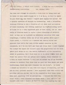 Bendigo Historical Society Inc.
Document - NORMAN OLIVER COLLECTION: SPEECH NOTES - TEN NOVELS I REGARD MOST HIGHLY. 1 OCTOBER 1951
The Norman Oliver collection. Norman Oliver was three times Mayor of Bendigo - 1950-51, 1964-65, 1970-71. Three copies of a speech, eight typed pages each, titled The ten novels I regard most highly. A talk for the Australian Broadcasting Commission. 1st October 1951. Corrections in blue ink and pencil. His ten nominated novels were : David Copperfield and Tale of Two Cities by Charles Dickins, Lorna Doone by R. D. Blackmore, War and Peace by Tolstoy, Kipps by H. G. Wells, Three Musketeers by Alexandre Dumas, Tell England by Ernest Raymond, Hypatia by Charles Kingsley, Treasure Island by Robert Louis Stevenson, and Pilgrim's Progress by John Bunyan. Norman Oliver served on the Library Board of Victoria.bendigo, council, speech notes, norman joseph oliver , councillor norman oliver. mayor of bendigo. australian broadcasting commission. -
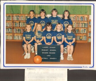 Bendigo Historical Society Inc.
Photograph - GOLDEN SQUARE LAUREL STREET P.S. COLLECTION: GSPS GRADE 4 NETBALL TEAM 1990
Coloured photograph of the Laurel Street Primary School, Golden Square Grade 4 Netball Team 1990. Photo taken in the library. Girls are wearing blue uniforms with monogrammed t shirts. In front of the girls is a board with the name of the school, year and Netball grade. Also a netball. Names of the girls are:- R MCCauley, B Fernie, E Wells, M Atkins, S Hoile, M Kerr, M Gerolomou, M Oldis and B Allan.education, primary, golden square laurel st p.s., golden square laurel street p.s. collection - photograph, gsps grade 4 netball team 1990, r mccauley, b fernie, e wells, m atkins, s hoile, m kerr, m gerolomou, m oldis, b allan