Showing 747 items
matching richer
-
 Orbost & District Historical Society
black and white photograph, second half 20th century
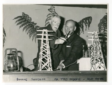
This was the switch on ceremony for the power going to Bonang. The ribbon was cut by Mr Ted Ingram at the age of 100. Ted Ingram, was one of 22 children. The Ingram family originated from the Bombala, Bonang and Delegate area, migrating throughout out the rich farming country of East Gippsland in the early 1900s.This is a pictorial record of a significant event in the history of East Gippsland.A black / white photograph of two men cutting the ribbon at an official occasion. The ribbno is strung between to models of electricity pylons. On the table to the left is a kerosene lantern.on front - "Bonang Switch on, Mr Ted Ingram, age 100 years"bonang-electricity-supply ingram-ted -
 Surrey Hills Historical Society Collection
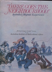
Book, Michael Dugan et al, There goes the Neighbourhood, 1984
The book presents a rich picture of a nation in the making. It is a portrait of Australia's development during the 19th and 20th centuries seen through the eyes of people arriving to make their homes here. It also looks at the new arrivals - those accepted and those rejected - from the points of view of people already established in the country.The book has a place in this collection by virtue of Michael Dugan having been a local resident.34 cm H; 200 p; includes chronology, List of sources and texts for each chapterTitle page: signed by one of the authors: Michael Dugansocial interaction--australia--history, australia - social life and customs, australia - social conditions, australia - emigration and immigration - history, minorities - australia - history, (mr) michael dugan, (mr) josef szware -
 Eltham District Historical Society Inc
Book, Jenny Brown et al, Out of the Mist; Osborne Peninsula, 2024
The Osborne Peninsula on the Yarra River at Warrandyte accommodates a limited number of properties and residents (70 households). The area is rich in geology and ecology, and an unusually rich endowment of human, built and creative history. Contents: Welcome: The landform: The River: Aboriginal occupation: The Miners: North Warrandyte :The Subdivision: The Lowes: The Osbornes: The Last Osborne: The Elders: The Relics: Dray Track: Water Wheel"Kauri Plaque: River track: Pines: Windmill Creek Bridge: The Koornong School: The Houses" Man Cave: MidCentury Classic: Enduring Original" Masterwork: The Muddies: The State Park: The Saving of Koornong Reserve: The Landcare Story: Flora and Fauna: The Vulnerable, Endangered and threatened: Birds: Mammals: "Waring" the wombat: Reptiles: Fish: Invertebrates: Flora: Fire. Published by the North Warrandyte (Osborne Peninsula) Landcare Group. Includes photos from EDHS collection.64 p. : ill., map ; 29.7 x 21 cm. (2 copies)yarra river, birrarung, dray track, fauna, geology, houses, indigenous history, koornong reserve, koornong school, lowe family, mining, mudbrick houses, north warrandyte, osborne family, warrandyte state park, water wheel, north warrandyte (osborne peninsula) landcare group, osborne peninsula -
 The Beechworth Burke Museum
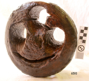
Geological specimen - Actionlite and Pyrite
Actinolite is usually found in metamorphic rocks, such as contact aureoles surrounding cooled intrusive igneous rocks. It also occurs as a product of the metamorphism of magnesium-rich limestones. Pyrite is usually found with other sulfides or oxides in quartz veins, sedimentary rock, and metamorphic rock, as well coal beds, and as a replacement mineral in fossils. Actinolite is an amphibole silicate mineral. It is named after the Greek word "aktinos" meaning “ray” in allusion to the mineral's fibrous nature. Fibrous actinolite is a type of asbestos and was once mined along Jones Creek at Gundagai, New South Wales. Pyrite or "Fool's Gold" is the most common sulfide mineral. It is named after the Greek "pyr" meaning "fire" because it can be used to create sparks needed for a fire if struck against metal or a hard surface. Due to its gold colour, pyrite can be mistaken for gold and often forms alongside it, causing small amounts of gold to be present in rocks containing pyrite. Most importantly, pyrite is an ore of gold. Pyrite is sometimes used as a gemstone but is not great for jewellery as it easily tarnishes. In some fossils of ammonites – shelled cephalopods that died ~66 million years ago – pyrite also replaces the shell. This specimen is part of a larger collection of geological and mineral specimens collected from around Australia (and some parts of the world) and donated to the Burke Museum between 1868-1880. A large percentage of these specimens were collected in Victoria as part of the Geological Survey of Victoria that begun in 1852 (in response to the Gold Rush) to study and map the geology of Victoria. Collecting geological specimens was an important part of mapping and understanding the scientific makeup of the earth. Many of these specimens were sent to research and collecting organisations across Australia, including the Burke Museum, to educate and encourage further study. A small-medium-sized solid specimen with the minerals actinolite (dark green fibrous) and pyrite (brassy) with shades of brown, black/grey, and white. Actinolite is an amphibole mineral in the tremolite-actinolite series of calcium, magnesium, and iron silicates. Pyrite is an iron disulfide mineral.geological specimen, geology, geology collection, burke museum, beechworth, indigo shire, geological, mineralogy, pyrite, actinolite, victoria, sewyln, alfred selwyn -
 Queenscliffe Maritime Museum
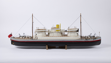
Craft - Model Cerberus, Charles Bonnici, November 2021
Demonstrating cutting edge maritime military technology, the Cerberus patrolled the waters in and around Melbourne, protecting it and its rich gold resources from attack. The Victorian gold rush coincided with growing instability in Europe. Britain and Russia prepared to face each other in battle as the threat of a second Crimean War grew.The HMVS Cerberus was one of only three vessels of its exact type ever built, and is the only surviving example of this type of vessel in the world. It is also the only substantially intact warship of Australia’s pre-Federation colonial navies. This shipwreck rests in shallow waters at Black Rock, Melbourne.HAnd built timber model of the HMVS CerberusCerberushmvs cerberus, model making -
 Flagstaff Hill Maritime Museum and Village
Functional object - Deadeye/Bullseye, circa 1873
Context: A deadeye or bullseye is an item used in the standing and running of sail rigging in traditional sailing ships. It is a smallish round thick wooden disc (usually lignum vitae) with one or more holes through it, perpendicular to the plane of the disc. History of the Loch Ard: The Loch Ard got its name from ”Loch Ard” a loch which lies to the west of Aberfoyle, and the east of Loch Lomond. It means "high lake" in Scottish Gaelic. The vessel belonged to the famous Loch Line which sailed many vessels from England to Australia. The Loch Ard was built in Glasgow by Barclay, Curdle and Co. in 1873, the vessel was a three-masted square-rigged iron sailing ship that measured 79.87 meters in length, 11.58 m in width, and 7 m in depth with a gross tonnage of 1693 tons with a mainmast that measured a massive 45.7 m in height. Loch Ard made three trips to Australia and one trip to Calcutta before its fateful voyage. Loch Ard left England on March 2, 1878, under the command of 29-year-old Captain Gibbs, who was newly married. The ship was bound for Melbourne with a crew of 37, plus 17 passengers. The general cargo reflected the affluence of Melbourne at the time. Onboard were straw hats, umbrella, perfumes, clay pipes, pianos, clocks, confectionery, linen and candles, as well as a heavier load of railway irons, cement, lead and copper. There were other items included that were intended for display in the Melbourne International Exhibition of 1880. The voyage to Port Phillip was long but uneventful. Then at 3 am on June 1, 1878, Captain Gibbs was expecting to see land. But the Loch Ard was running into a fog which greatly reduced visibility. Captain Gibbs was becoming anxious as there was no sign of land or the Cape Otway lighthouse. At 4 am the fog lifted and a lookout aloft announced that he could see breakers. The sheer cliffs of Victoria's west coast came into view, and Captain Gibbs realised that the ship was much closer to them than expected. He ordered as much sail to be set as time would permit and then attempted to steer the vessel out to sea. On coming head-on into the wind, the ship lost momentum, the sails fell limp and Loch Ard's bow swung back towards land. Gibbs then ordered the anchors to be released in an attempt to hold its position. The anchors sank some 50 fathoms - but did not hold. By this time the ship was among the breakers and the tall cliffs of Mutton Bird Island rose behind. Just half a mile from the coast, the ship's bow was suddenly pulled around by the anchor. The captain tried to tack out to sea, but the ship struck a reef at the base of Mutton Bird Island, near Port Campbell. Waves subsequently broke over the ship and the top deck became loosened from the hull. The masts and rigging came crashing down knocking passengers and crew overboard. When a lifeboat was finally launched, it crashed into the side of Loch Ard and capsized. Tom Pearce, who had launched the boat, managed to cling to its overturned hull and shelter beneath it. He drifted out to sea and then on the flood tide came into what is now known as recovered from the wreck of the Loch ArdGorge. He swam to shore, bruised and dazed, and found a cave in which to shelter. Some of the crew stayed below deck to shelter from the falling rigging but drowned when the ship slipped off the reef into deeper water. Eva Carmichael a passenger had raced onto the deck to find out what was happening only to be confronted by towering cliffs looming above the stricken ship. In all the chaos, Captain Gibbs grabbed Eva and said, "If you are saved Eva, let my dear wife know that I died like a sailor". That was the last Eva Carmichael saw of the captain. She was swept off the ship by a huge wave. Eva saw Tom Pearce on a small rocky beach and yelled to attract his attention. He dived in and swam to the exhausted woman and dragged her to shore. He took her to the cave and broke the open case of brandy which had washed up on the beach. He opened a bottle to revive the unconscious woman. A few hours later Tom scaled a cliff in search of help. He followed hoof prints and came by chance upon two men from nearby Glenample Station three and a half miles away. In a complete state of exhaustion, he told the men of the tragedy. Tom then returned to the gorge while the two men rode back to the station to get help. By the time they reached Loch Ard Gorge, it was cold and dark. The two shipwreck survivors were taken to Glenample Station to recover. Eva stayed at the station for six weeks before returning to Ireland by steamship. In Melbourne, Tom Pearce received a hero's welcome. He was presented with the first gold medal of the Royal Humane Society of Victoria and a £1000 cheque from the Victorian Government. Concerts were performed to honour the young man's bravery and to raise money for those who lost family in the disaster. Of the 54 crew members and passengers on board, only two survived: the apprentice, Tom Pearce and the young woman passenger, Eva Carmichael, who lost her family in the tragedy. Ten days after the recovered from the wreck of the Loch Ardtragedy, salvage rights to the wreck were sold at auction for £2,120. Cargo valued at £3,000 was salvaged and placed on the beach, but most washed back into the sea when another storm developed. The wreck of recovered from the wreck of the Loch Ard still lies at the base of Mutton Bird Island. Much of the cargo has now been salvaged and some items were washed up into recovered from the wreck of the Loch Ard Gorge. Cargo and artefacts have also been illegally salvaged over many years before protective legislation was introduced in March 1982. One of the most unlikely pieces of cargo to have survived the shipwreck was a Minton majolica peacock- one of only nine in the world. The peacock was destined for the Melbourne 1880 International Exhibition in. It had been well packed, which gave it adequate protection during the violent storm. Today the Minton peacock can be seen at the Flagstaff Hill Maritime Museum in Warrnambool. From Australia's most dramatic shipwreck it has now become Australia's most valuable shipwreck artifact and is one of very few 'objects' on the Victorian State Heritage Register. The shipwreck of the Loch Ard is of significance for Victoria and is registered on the Victorian Heritage Register ( S 417). Flagstaff Hill has a varied collection of artefacts from Loch Ard and its collection is significant for being one of the largest accumulation of artefacts from this notable Victorian shipwreck. The collections object is to also give us a snapshot into history so we can interpret the story of this tragic event. The collection is also archaeologically significant as it represents aspects of Victoria's shipping history that allows us to interpret Victoria's social and historical themes of the time. The collections historically significance is that it is associated unfortunately with the worst and best-known shipwreck in Victoria's history. Ship’s deadeye comprising a thick round wooden disc, pierced by 3 similarly sized and shaped holes from one flat side through to the other, in a triangle formation. It has been polished a rich dark colour and a crude mouth has been carved below the 'eyes' to create a curio effect. These alterations are most likely to have been made after the object was retrieved from the sea, (when it was used as a doorstop).Noneflagstaff hill, warrnambool, shipwrecked-coast, flagstaff-hill, flagstaff-hill-maritime-museum, maritime-museum, shipwreck-coast, flagstaff-hill-maritime-village, deadeye, loch ard, rigging -
 Melbourne Tram Museum
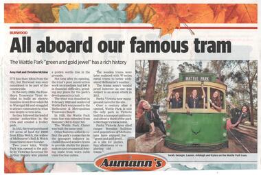
Newspaper, Whitehorse Leader, "All aboard our famous tram", 23/04/2018 12:00:00 AM
Newspaper clipping from the Whitehorse Leader, Monday 23/4/2018 titled "All aboard our famous tram", subtitled "The Wattle Park 'green and gold jewel' has a rich history". Story about the history of the park, and the tramlines in the district, tramcars that have been placed there. Parks Victoria now managing the site. Has a photo of five girl scouts on one of the trams. Story by Amy Hall and Christine McGinn.trams, tramways, wattle park, tramcars -
 Blacksmith's Cottage and Forge
Tin, Stove Polish
One of the jobs of the housewife was to keep her stove-top looking clean and new, and a rich black colour. This was a source of pride amongst house-proud women, and also ensured a more efficient distribution of heat on their stove-tops for cooking. It was however one of the dirtiest jobs in the kitchen, requiring a lot of elbow-grease as well as a good polish paste. Local. The use of the magpie emblem denotes the emergence of a new nationalism, a pride in being Australian, as distinct from being "British", although Australians continued to see themselves as part of the greater British Empire and subjects of the King.Gold tin with push-in lid, with picture of magpie in black and white on branch. On front of tin: "Magpie" in white letters on a red background. "Stove Polish" in white letters on a blue background. 4 oz. Net. when packed. Made in Australia. On bottom of tin: "Grate & Stove Polishing Paste. Made in Australia." Side inscriptions give instructions for use. -
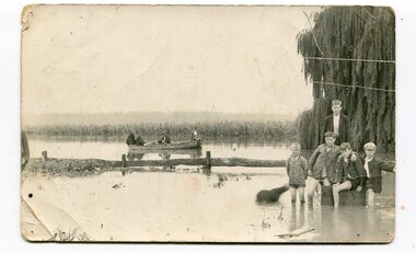 Orbost & District Historical Society
black and white photograph, 1934
This photograph was taken during the flood of 1934 in Orbost. The people in the photograph are related to Billie and Ilma Nixon and Charlie Johnston. Damage estimated at £500,000 was caused by the 1934 floods in the Orbost district. This 1934 flood was devastating, destroying a section of the 1922 Orbost bridge, wrecking fences, bridges and roads, dumping silt and debris on the rich river flats and drowning cattle.This item is a pictorial record of a significant event in Orbost's history. It is associated with local families.A black / white photograph / postcard of floodwaters. On the right is a young man with four young boys sitting on a log. In the bckground is a rowing boat with one man rowing and three others sitting on the edges . A field of maize / corn is in the background and a large willow tree on the right.on back - "M. C. Rice Orbost 19 /1/20 M Gilbert. Mostly Billy Nixons & Charlie Johnstons 1934" [Note alteration: W C Rice rather than M C Rice].floods-orbost-1934 nixon-william johnston-charles -
 Mont De Lancey
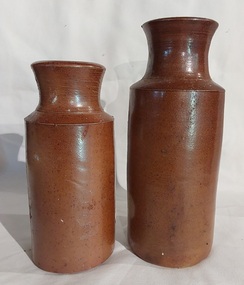
Container - Pottery Bottles, Unknown
One of the jobs of the housewife was to keep her stove-top looking clean and new, and a rich black colour. This was a source of pride amongst house-proud women, and also ensured a more efficient distribution of heat on their stove-tops for cooking. It was however one of the dirtiest jobs in the kitchen, requiring a lot of elbow-grease as well as a good polish paste or blacking ink.Two brown pottery blacking bottles, one with a light brown glaze and other is dark brown. Both have shaped wide necks with a lip at the edge for pouring. The contents were used to blacken a stove. blacking bottles, bottles, cooking equipment, cooking stoves, fuel cooking stoves, domestic ovens -
 Bendigo Historical Society Inc.
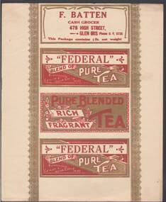
Document - CAMBRIDGE PRESS COLLECTION: LABEL - FEDERAL PURE TEA
Sheet with the four side labels for a tea packet. Two are the same with the name- Federal Pure Tea and where the tea came from, One has F Batten, Cash Grocer, 475 High Street, Glen Iris, the phone number and the weight of the tea. The fourth has Pure Blended Rich Fragrant Tea. It has some floral decoration. Printed in red and gold on a cream background. Has lacy pattern down each side of the labels.business, printers, cambridge press, cambridge press collection, f batten, federal pure tea -
 Bendigo Historical Society Inc.
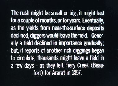
Slide - DIGGERS & MINING. DIGGERS AND MINERS, c1857
BHS CollectionDiggers & Mining. Diggers and miners. The rush might be small or big; it might last for a couple of months, of for years. Eventually, as the yields from near-the-surface deposits declined, diggers would leave the field. Generally a field declined in importance gradually; but, if reports of another rich diggings began to circulate, thousands might leave a field in a few days - as they left Fiery Creek (Beaufort) for Ararat in 1857. Markings: 20 994:LIF I. Used as a teaching aid.hanimounteducation, tertiary, goldfields -
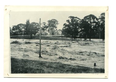 Orbost & District Historical Society
black / white photograph, January 1934
Damage estimated at £500,000 was caused by the 1934 floods in the Orbost district. This 1934 flood was devastating, destroying a section of the 1922 Orbost bridge, wrecking fences, bridges and roads, dumping silt and debris on the rich river flats and drowning cattle. This photograph shows Lochiel Lagoon ( the billabong) in the foreground. Ten minutes after this photograph was taken, the centre span of the Orbost Bridge was washed away.This item is a pictorial record of the 1934 floods, a significant part of Orbost's history.A black / white photograph of swirling floodwaters with township in the background.orbost-floods-1934 natural-disasters-floods -
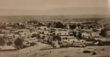
 Bendigo Historical Society Inc.
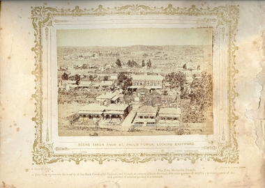
Photograph - VIEWS OF BENIDGO: LOOKING EAST FROM ST.PAUL'S CHURCH, 1875 copy,1970
Sepia photo on a cream board. Shows houses viewed east from St.Pauls Church. Inscription: 'Views of Bendigo|No.41.'. Below, 'Scene taken from St. Paul's tower, looking Eastward.', 'N.J.Caire Photo, Sandhurst'. Bottom, 'Casey & Wenborn's Print Forbes & Holmes, Agents',' This view represents the locality of the Back Creek gold digging, and though at present almost deserted, was once a scene of activity, in consequence of the rich patches of alluvial ground it contained'. Nicholas CaireN.J.Caireplace, bendigo, view east from st.paul's church, see: 'views of bendigo' by n.j.caire, 'mp?' -
 Victorian Aboriginal Corporation for Languages
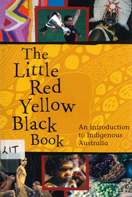
Book, Bruce Pascoe, The little red yellow black book : an introduction to Indigenous Australia, 2008
The Little Red Yellow Black Book is an accessible and highly illustrated pocket-sized guide. It's an invaluable introduction to Australia's rich Aboriginal and Torres Strait Islander histories and culture. It takes a non-chronological approach and is written from an Indigenous viewpoint. The themes that emerge are the importance of identity, and adaptation and continuity. If you want to read stories the media don't tell you, mini-essays on famous as well as everyday individuals and organisations will provide insights into a range of Australian Indigenous experiences.maps, b&w photographs, colour photographsindigenous history, culture, art, sport, health, education, employment, reconciliation, resistance, governance -
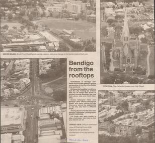 Bendigo Historical Society Inc.
Newspaper - JENNY FOLEY COLLECTION: BENDIGO FROM THE ROOFTOPS
BHS CollectionBendigo Advertiser from April 24, 2002. Bendigo from the rooftops: Bendigo Advertiser photographer Mark Farrugia took these 4 photo from an helicopter during the Easter long weekend. Top left: a lush Tom Flood sports centre makes a welcome change to the barren ovals of last year. Top right: the cathedral towers over high Street. Bottom left: an overhead view of Charing cross. Right bottom: the rich goldfields architecture of the city centre. The clip in in a folder.newspaper, bendigo advertiser -
 Bendigo Historical Society Inc.
Document - VICTORIA HILL - RECOMMENDATION - MINING PROJECT
Two (a & b) typed copy of a recommendation for mining project, accepted Nov. 1967. Recommendation for Central Nell Gwynne area, now a public purposes reserve for preservation as a permanent reminder of the gold mining era. Victoria Hill Area mentioned for it's geographical and historical significance. The New Chum Hill area rich in historical and mining. Notes on development of the Central Nell Gwynne, Victoria Hill and New or Old Chum Hill areas. Notes prepared by Albert Richardson.mine, gold, victoria hill, victoria hill, recommendation - mining project, central nell gwynne, jack barker, victoria hill area, big 180, victoria quartz, new chum hill (old chum hill), p. m. g. repeater station, mine's department, land's department, lansell, fortuna, a h q survey regiment, lazarus mine, b c v 8 television studio -
 Bendigo Historical Society Inc.
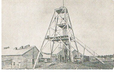
Postcard - GREAT EXTENDED HUSTLERS MINE - POSTCARD OF POPPET LEGS & BUILDINGS
Grey & white postcard showing poppet legs and buildings at the Great Extended Hustlers Mine. Printed on the back: 'Royal Historical Society of Victoria Bendigo Branch. Great Extended Hustlers Locality: Hustlers Hill, Nth. Bendigo Formed 1865 - Last production 1921 Depth of shaft - 3,470 feet Poppet Legs - Steel, 70 feet high Winding Engine: First motion, 8 ft. Drums. Gold Very Rich Total yield - 300,000 oz. Dividends 675,000 Poundsmine, gold, great extended hustlers mine, hustlers hill nth bendigo -
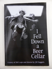 Warrnambool and District Historical Society Inc.
Book, I fell down a beer cellar, 2004
This is the autobiography of Jill Suggett, born 1940, the daughter of Lindsay and Enid Suggett of Warrnambool. She suffered from cerebral palsy and, in later life, bi-polar disorder. Despite this she lived a rich and active life, becoming a librarian and publishing several books. She was a member of the Warrnambool and District Historical Society and was the newsletter editor for the Society from 1968 to 1976 and was a Life Member of the Society. This book is of interest as it is the autobiography of Jill Suggett, a life member of the Warrnambool and District Historical Society (Jill is now deceased). This is a soft cover book of 120 pages. The cover has a black background and a black, grey and white image of a girl tumbling into a cellar. The lettering on the front cover is white and on the spine it is black. On the back cover there is a printed extract from the Foreword. The book has a Foreword, 21 chapters and several black and white photographs. The inscription is handwritten in blue biro. ‘Donated by Reg. Smith 2005’ history of warrnambool, jill suggett -
 Warrnambool and District Historical Society Inc.
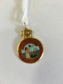
Badge, Port of Warrnambool Flagstaff Hill, Late 20th century
Flagstaff Hill is a maritime museum which draws on the rich maritime history of the region. It is situated overlooking Lady Bay in Warrnambool and is designed to represent the town of Warrnambool in around the 1870-80’s As well as paid staff on site it enjoys a large volunteer group who do various tasks around the village from tours to maintenance and recording of information. This badge recognises the contribution of one such volunteer. An item which recognizes effort in the local community.Round gold edged medal with picture of lighthouse and flagstaff surrounded by red with gold lettering. Number engraved on back.698 engraved on back. Port of Warrnambool Villager 1850. Flagstaff Hillflagstaff hill badge, warrnambool -
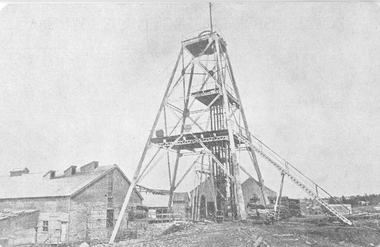
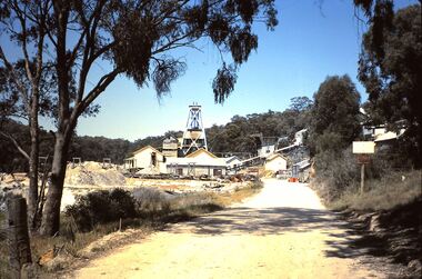 Bendigo Historical Society Inc.
Slide - HORWOOD COLLECTION - WATTLE GULLY, c1965
Wattle Gully, at Chewton was first worked in 1853 albeit initially only to a depth of 10 metres. An exploratory drilling in 1934, that deflected off course, discovered new rich gold seams and by 1937 large amounts of gold were being extracted. The mine closed in 1969 because high water levels and the low price of gold made it unprofitable at the time. It has operated intermittently since then.Horwood Collection - Wattle Gully. Wattle Gully Mine, Chewton. Much of the buildings and other structures still remain. Markings Wattle Gully Chewton. DEC65MKodakmine, gold, walltle gully, horwood collection - wattle gully. wattle gully mine, chewton. much of the buildings and other structures still remain -
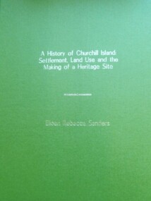 Churchill Island Heritage Precinct
Book - Thesis, Dr E. Rebecca Saunders, A History of Churchill Island: Settlement, Land Use and the Making of a Heritage Site, 2015
An exploration of the intersections between the practices of community engagement, academia and history, the thesis responds to the challenges thrown up by the History Wars and the Churchill Island Project by making a history of settlement that is both academically critical and publicly accepted.A4 format bound text, with green front and back covers and gold writing on front page.non-fictionAn exploration of the intersections between the practices of community engagement, academia and history, the thesis responds to the challenges thrown up by the History Wars and the Churchill Island Project by making a history of settlement that is both academically critical and publicly accepted.saunders, churchill island, settlement, land use, heritage site, thesis 2015 -
Glen Eira Historical Society
Article - Little Cromer, Kooyong Road, 235, Elsternwick
Photocopied article from Australian Jewish News April 20, 2001 titled A Rich History on the property Little Cromer, 235 Kooyong Road Elsternwick, which is to be auctioned on April 29, 2001. Includes one exterior and one interior photograph. Also includes print of entry for Bellecourt, 85 Seymour Road from Victorian Heritage Database which notes that Little Cromer was formerly called Neringakooyong road, elsternwick, little cromer, hughes allan, hughes marjorie, air raid shelters, beemery park, langdon henry, langdon montague, renwick samuel, blanche street, neringa, langdon charles petley, sadleir john, schreiber robert henry, architect, auctions, roof, gables, stables, gary peer and associates, parsons charles, moloney james, trezise alex, vassy albert, johnston mr., johnston mrs., bellecourt -
 Ballarat Heritage Services
Image, Stawell, c1918, c1918
Pastoral runs in the Stawell area were selected in the 1840s, but it was the gold found by a shepherd in the district in May 1853 that provided the real reason for the foundation of a township. By August 1854, 5,000 people were seeking their fortune at the Pleasant Creek goldfield. By 1857 the fabulously rich deep alluvial leads to Commercial Street and Deep Lead had been discovered and rushes of eager gold seekers brought 20,000 people to the fields.Black and white photograph of the central Victorian town of Stawell (formerly known as Pleasant Creek). .stawell, pleasant creek -
 Otway Districts Historical Society
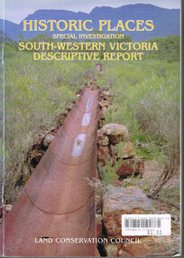
Book, Land Conservation Council, Historic places: Special investigation: South-Western Victoria: Descriptive report, January 1996
The south-west of Victoria, possessing a rich heritage of the signs of past human activity, is fertile ground for an investigation of historic places on public land. This report includes an initial inventory of almost 2000 places. The report outlines the history and the related heritage of the area, describes in some detail its biophysical attributes and introduces the natural resources and present land use. This information provides a context for understanding the origins of the historical features that are observes today.Historic places: Special investigation: South-Western Victoria: Descriptive report. Land Conservation Council. Land Conservation Council; Melbourne (Vic); January 1966. viii, 180 p.; illus.; maps. Soft cover. ISBN 0 7241 9288 3Maps in plastic sleeve.land conservation council; conservation; south-western victoria; historic places; -
 Federation University Art Collection
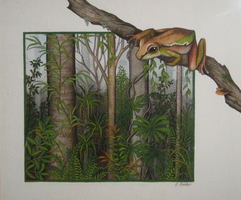
Painting, Lyn Cooke, 'Rainforest Home' by Lynne Cooke
Lyn COOKE An artist specialising in wildlife, Lyn Cooke draws from the rich heritage of wildlife art in Australia beginning with the natural history illustrations of John William Lewin and John and Elizabeth Gould. Her aim is to accurately depict the natural environment and this is reflected in her highly detailed paintings. This item is part of the Federation University Art Collection. The Art Collection features over 2000 works and was listed as a 'Ballarat Treasure' in 2007.Framed painting of a frog in landscape.Signed lrs 'L. Cooke'art, artwork, lyn cooke, frog, available, rainforest -
 Eltham District Historical Society Inc
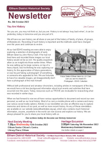
Journal - Newsletter, Newsletter, No. 266 October 2022, Oct 2022
Contents: • You Are History by Jim Connor • Our Next Meeting – 7.30pm Wednesday 12th October 2022 • Heritage Excursion – Montmorency Bushland Reserves - Saturday 5th November • Sibbel Builders – A Rich History by Jim Connor • Reminiscences of 1930s Eltham by Edith Jones (nee McLean) • Reflections of Growing Up in Research by Lyn Hardiman (nee Dodkins) • Eltham Cemetery Stories by Liz Pidgeon o Mary Carrucan The Shire of Eltham Historical Society was formed in October 1967. The first newsletter of the Society was issued May 1978 and has been published continuously ever since on a bi-monthly basis. With the cessation of the Shire of Eltham in late 1994, the Society's name was revised to Eltham District Historical Society and this name first appeared with issue No. 103, July 1995. The collection of the Society's newsletters provides a valuable resource on the history of the Society's activities, office bearers and committee members, guest speakers and subjects of historical interest pertinent to the former Shire of Eltham and the Eltham District.A4 newsletter distributed to members (Digital and A4 photocopy)newsletter, eltham district historical society -
 Bendigo Historical Society Inc.
Photograph - EXTENDED HUSTLERS FREEHOLD
black and white photograph of Great Extended Hustlers Freehold poppet head, now at Wattle Gully, Chewton ( james Lerk 26.22.1999 ) Poppet head in front of mining buildings, stacks of sawn timber tonight. Great Extended Hustlers/locality/Hustlers Hill Nth. Bendigo/ formed 1865/last production 1921. Depth of shaft 3,470 ( 1045 m ) Poppet legs, steel 70 feet high ( 21.08 ) Gold very rich, total yield 300,000 ozs. Dividends 675,000 pounds sterling ( $1,350,000 )organization, business, great extended hustlers mine -
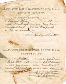 Bendigo Historical Society Inc.
Document - ANCIENT ORDER OF FORESTERS NO. 3770 COLLECTION: CORRESPONDENCE
A.O.F., Court King of the Forest, No. 3770, B.U.D. Notice of Intention and Proposition. I hereby give notice of Intention to Propose Mr. Thomas White, age 28 years, Occupation Blacksmith, Place of Birth England, residence Iron Bark, Wife's Name Margaret Age 26 years, No of Children 1. Signature Rich Coath. The Proposition - Proposed by R. J. Coath and Seconded by Ed. Le Levies. Mr Thomas White as a Candidate for admission. Proposed by R. J. Coath and Seconded by Ed. Le Levies.societies, aof, correspondence, ancient order of foresters no. 3770 collection - correspondence, court king of the forest, thomas white, margaret white, rich coath, ed le levies -
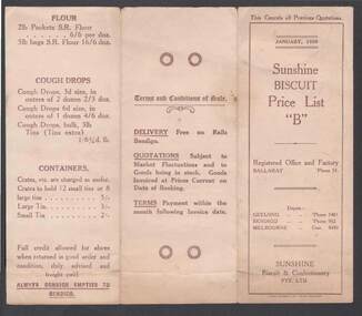 Bendigo Historical Society Inc.
Document - SUNSHINE BISCUIT PRICE LIST 'B'
Sunshine Biscuit Price List 'B' dated January 1926. Registered Office Ballarat, Phone 53. Depots, Geelong, Bendigo, Melbourne. Terms and Conditions of Sale Listed. Delivery Free on Rails Bendigo. Quotations Subject to Market Fluctations and to goods in Stock. Terms Payment within the Month following Invoice Date. Prices of Various Dry Biscuits, Semi-Sweet Biscuits, Sweet Biscuits, Rich Dessert and Cream Biscuits, Specialties, Holiday Mixture, Cakes, Sunshine Party Packets,Flour, Cough Drops and containers.bendigo, industry, biscuit making, sunshine biscuit co. 1926 price list of biscuits