Showing 113961 items
matching road-making
-
 Kew Historical Society Inc
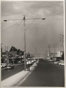
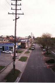
Photograph, Stuart Tompkins Studio, Electricity Supply Poles, North Road, Ormond, 1965
Research provided by Stuart Tompkins Studio, Box Hill, into alternatives for median strip street lighting to be used in Burke Road, Kew. The photographers identified variants in different suburbs appropriate to Kew's needs.The series from which the photograph is drawn provides a snapshot by a commercial photographic studio of each named vicinity in 1965 as well as providing examples of public works infrastructure being commissioned by local government in the 1960s. The photos originally formed part of the Engineering Department's files in the City of Kew before being donated to the kew Historical Society.Electricity Supply Poles, North Road, Ormond, 1965. Electricity supply poles photographed for the Kew City Council by Stuart Tompkins Studio. The photograph of North Road, Ormond west of Jasper Road, looking east depicts wooden poles carrying two lamps in a median strip and with two on each side alternately. It was noted that the supply wires were from one side only. The poles were described as 3′ above ground and 11.25″ in diameter. The plan was to use this approach for Burke Road, Kew. [There are three copies of this photograph in the Collection.] Typed inscription on reverse: "Electricity Supply Poles. Photographed for Kew City Council 8/2/65. No.1 North Road - Ormond, west of Jasper Road, looking east. Wooden poles carrying two lamps in median strip and two on each side alternately just as is proposed for Burke Road, Kew. Supply wires from one side only. Poles 3' above ground 11 1/4" dia." Studio stamp: "Stuart Tompkins Studio. 547 Station Street, Box Hill. WX1439."stuart tompkins studio, street lighting, south road (moorabin) 1965 -
 Kew Historical Society Inc
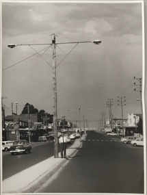
Photograph, Stuart Tompkins Studio, Electricity Supply Poles, North Road, Ormond, 1965
Research provided by Stuart Tompkins Studio, Box Hill, into alternatives for median strip street lighting to be used in Burke Road, Kew. The photographers identified variants in different suburbs appropriate to Kew's needs.The series from which the photograph is drawn provides a snapshot by a commercial photographic studio of each named vicinity in 1965 as well as providing examples of public works infrastructure being commissioned by local government in the 1960s. The photos originally formed part of the Engineering Department's files in the City of Kew before being donated to the kew Historical Society.Electricity Supply Poles, North Road, Ormond, 1965. Electricity supply poles photographed for the Kew City Council by Stuart Tompkins Studio. The photograph of North Road, Ormond west of Jasper Road, looking east depicts wooden poles carrying two lamps in a median strip and with two on each side alternately. It was noted that the supply wires were from one side only. The poles were described as 3′ above ground and 11.25″ in diameter. The plan was to use this approach for Burke Road, Kew. [There are three copies of this photograph in the Collection.] Typed inscription on reverse: "Electricity Supply Poles. Photographed for Kew City Council 8/2/65. No.1 North Road - Ormond, west of Jasper Road, looking east. Wooden poles carrying two lamps in median strip and two on each side alternately just as is proposed for Burke Road, Kew. Supply wires from one side only. Poles 3' above ground 11 1/4" dia." Studio stamp: "Stuart Tompkins Studio. 547 Station Street, Box Hill. WX1439."stuart tompkins studio, street lighting, south road (moorabin) 1965 -
 Whitehorse Historical Society Inc.
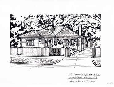
Artwork, other - Ink Line Drawing, Margaret Picken, 8 Menin Road., Nunawading, 1997
A property illustration by Margaret Picken Commissioned by a real estate agency for the purpose of advertising 8 Menin Road., Nunawading. This property is listed as having sold for $225,000 in 1997 Made by using Rotring ‘Rapidigraph’ drafting pens with Rotring ink on Rapidigraph polyester drafting film, double matte. Trained as a cartographic draftsman within the mining industry, Margaret Picken is an artist who worked producing property illustrations for real estate agencies in eastern suburbs of Victoria from 1983-2005. Retiring from the industry as technological changes favored coloured photography over illustrations, and commissioning companies over sole contractors.This artwork is of Historical Significance as a record of local domestic architecture.A black ink line drawing on drafters film by Margaret Picken, of a black and white line drawing of a single story weatherboard house with bullnose verandah covering the front porch. On the right is a driveway leading to a separate garage in the background. In the foreground is a picket fence enclosing the front garden. black and white line drawing of a single story weatherboard house, with a driveway on the right leading to a separate garage in the background. In the foreground is a front garden, with garden beds and central tree. There are two holepunch holes on just under the upper edge.8 Menin Road., Nunawading Margaret Picken - 97 Woodards - B/Burnwhitehorse historical society, schwerkolt cottage, housing, architecture, margaret picken, house, garden, real estate, nunawading -
 Greensborough Historical Society
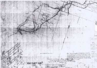
Document - Road Plan, Road acquisition, St Helena Road, 1859, 1889
Road plan showing land acquisition for the road to Diamond Creek (NOT Diamond Creek Road), also known as Eltham Road and now known as St Helena Road.Shows the land through which St Helena Road runs, with original owners marked on plan.1 page. Copy of road planroad plans, st helena road greensborough, diamond creek -
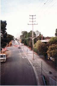
 Whitehorse Historical Society Inc.
Photograph, Whitehorse Road, 1/06/1999 12:00:00 AM
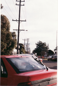
Coloured photo of Whitehorse Road, Mitcham, opposite Doncaster East Road looking toward Mitcham Road.whitehorse road, overhead powerlines -
 Marysville & District Historical Society
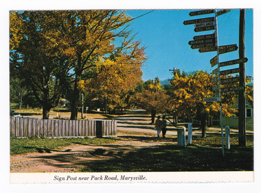
Postcard (item) - Colour postcard, Nucolorvue Productions Pty. Ltd, Sign Post near Pack Road, Marysville, Pre 2009
A colour photograph of the sign post that once stood opposite Pack Road in Marysville in Victoria.A colour photograph of the sign post that once stood opposite Pack Road in Marysville, Victoria. This corner was known as Signpost Corner. This postcard was produced by Nucolorvue Productions as a souvenir of Marysville.NU-COLOR-VUE/ OF/ AUSTRALIA MARYSVILLE, VICTORIA./ Sign post opposite Pack Road at/ Autumn. PLACE/ STAMP/ HERE POST CARD NCV.170 - NUCOLORVUE PRODUCTIONS PTY. LTD./ COPYRIGHT Printed in Australiamarysville, victoria, sign post, postcard, souvenir, nucolorvue productions, signpost corner, pack road -
 Ringwood and District Historical Society
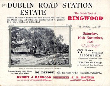
Pamphlet, Land Sale Brochure, Dublin Road Station Estate - 1923
"Extracts from Recent Daily Newspaper - Ringwood Train Service - STATION WANTED AT RINGWOOD EAST. A deputation from the Ringwood East Railway League and Progress Association waited on the chairman of the Railway Commissioners yesterday afternoon and asked that a railway station be erected at Dublin-road, a mile and a quarter from Ringwood. The deputation urged that there were 81 passengers who, if the station were provided, would make daily use of it, and that as the Commissioners had purchased a site for a station at Dublin-road it was evident they had at one time considered it the most suitable site. The Chairman of Commissioners stated that the estimated cost of the station was £3700. Land owners in the locality should pay a proportion of the cost. Members of the deputation replied that there would be no difficulty in raising the money."Multi-fold brochure advertising public auction of residential allotments on Saturday, 10th November, 1923. Brochure includes subdivision features, local facilities and photographic images of the area and details of proposed new railway station at Dublin Road.Subdivision plan includes Dublin Road, Alexandra Road, Vonadawn Avenue, Green Street, Howard Avenue, Wood Street, and Bedford Road (Main Ferntree Gully Road). Auctioneer - Knight & Harwood, 315 Collins Street, Melbourne, Phones Central 10615, 10616. Agent - J.B. McAlpin, Opposite Railway Station, Ringwood, Phone Ringwood 7. -
 Mission to Seafarers Victoria
Film - DVD, Port of Melbourne Corporation, The Making of Crowd Theory, 2008
In 2008, the photographer Simon Terrill, organised a photo shoot of a crowd in the industrial port of Melbourne. The photographs were exhibited in the Norla Dome. The film tells about the making of the photo shoot and documents the exhibition.crowd theory, 2008, norla dome, the port of melbourne, simon terrill, footscray community arts centre, mission to seafarers -
 Ringwood and District Historical Society
Photograph, Mansourah Picture Framing, Buildings in Canterbury Road Heathmont, February 1960, Feb-60
Peter Le Get found three framed photos of Heathmont view in a Heathmont Opportunity Shop. Previous owners unknown.Framed photograph of buildings in Canterbury Road Heathmont, February 1960.Heathmont, February 1960, Canterbury Road -
 Whitehorse Historical Society Inc.
Newspaper - Article, 25-29 Glenburnie Road, Mitcham, 15/05/1996
Sale advertisement for 25 - 29 Glenburnie Road, Mitcham, known as 'Old Daffodil Farm'. Also 95 Morack Road, Vermont South for auction.glenburnie road, mitcham, nos. 25-29, old daffodil farm, morack road, vermont south, no. 95, auctions -
 Stawell Historical Society Inc
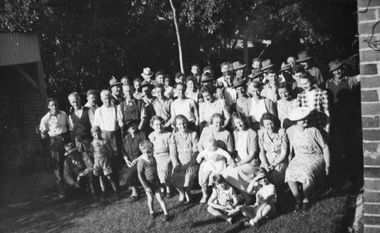
Photograph, North Park Volunteers instrumental in making North Park at the home of Mr G LaGerche 1948, 1948
Group of North Park Volunteers 1948 instrumental in making North Park. Taken in backyard of Mr G LaGerche's home Cnr Houston and Lamont Streets. This snapshot was donated by miss Glenda Hurst - Stawell - to the Society - Black and White Photograph of a large group of persons - Background of trees.On rear: North Park Volunteers 1948. Taken in the back garden of Mr G LaGerche (morning Tea). Men L to R Roy Hurst, Alan Willoughby, Fred Crouch, Arthur Parsons, Cyril Cashin, Glynn Cashin. Ladies Second Row L to R: Mrs Edna(Geoff) LaGerche, Mrs Pretty, ?, Mrs Darling, Ladies in front Row: ?, ?, Mrs Ted Mills, Mrs Harold Dunn, Miss Dorothy Kingston, Mrs Bess (bill) Wilson, ?, . Farmers brought in their Not Horse drawn graders, etc to form the two (2) ovals at "The Pug" Photo property R.W. Hurst. 29 Houston Street Stawellstawell, north park -
 Ringwood and District Historical Society
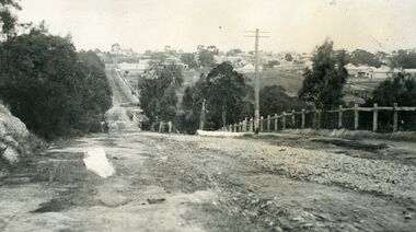
Photograph, Looking south down Warrandyte Road, Ringwood around 1920
Black and white photograph taken just below where Mullum Mullum Road meets Warrandyte Road.The Mullum Mullum Bridge can be seen in the dip, with numerous houses on the ridge on Whitehorse Road (Maroondah Highway). The fencing was post and rail, with Warrandyte Road unmade, sealed with crushed rocks. -
 Kew Historical Society Inc
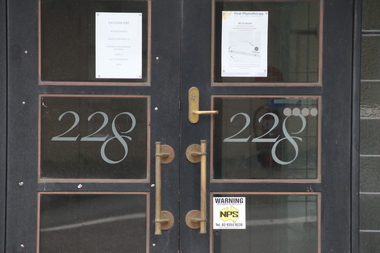
Photograph - Photographs (series), Richard Bowen, Sunninghill, 228 Cotham Road, 07/02/2020
'Sunninghill' at 228 Cotham Road (Kew) is an historically significant building due to its associations with Joseph Thomas (Bland) Holt (1851-1942), theatre entrepreneur and actor who lived at the house following his retirement in 1909. Sunninghill (aka Sunning Hill) was one of his residences in Victoria (also 'The Anchorage' at Sorrento). Following Holt's death at Sunninghill on 28 June 1942, the house was left to his wife. After her death the house was bequeathed to Lucy Coppin, daughter of George Coppin. The 'Shakespeare Window' in the State Library of Victoria was at one stage installed in the house. References 'Death of Mr Bland Holt: Great exponent of melodrama', The Argus, 30 June 1942, p. 3. Shoesmith D, 'Holt, Joseph Thomas (Bland) (1851-1942)', Australian Dictionary of Biography, Vol 4, 1972. 'The Shakespeare Window', State Library of Victoria website.Exterior photographs (digital) of Sunninghill, 228 Cotham Road, Kew VIC 3101. sunninghill - 228 cotham road - kew (vic), joseph thomas (bland) holt, lucy coppin -
 Mt Dandenong & District Historical Society Inc.
Photograph, Jasper Road Near Erith Lane 1920, 1920
View of Jasper Road, near Erith Lane taken in 1920. The road is tree lined with two significant gum trees in the foreground. This photograph has a detailed inscription on the back handwritten by John Lundy-Clarke in 1974.Jasper Road near Erith Lane 1920. This road has only a narrow right of way. It was put in as a road to serve “Cherry Farm”, connecting it to the Coach Road at the Elbow in 1904. It joins a wide surveyed road running from Inverness Road to the Coach Road at the Elbow and could possibly have been surveyed by Thomas Hand at the same time as Inverness Road. The name Jasper now applies to full length between Erith Lane and Coach Road. McGivern Bros widened it in 1937 and J L Clarke removed and stored much of the rock quarried in the widening. This was later sold to Dick Moorby who sold it to the builders of St Michaels Church in Falls Road. Comment by John Lundy-Clarke 10.5.1974 jasper road, erith lane, john lundy-clarke -
Victorian Aboriginal Corporation for Languages
Book, Rosalind Berry et al, Making the jump : a resource book for teachers of Aboriginal students, 1997
The focus of Making the Jump is the acceptance of Aboriginal students' home language, and the use of that language as a jumping off point for teaching Standard Australian English. It is a valuable classroom resource for teachers working with students whose home language is Kriol or Aboriginal English. Ch. 1. First impressions Ch. 2. Cultures in the classroom Ch. 3. Understanding the languages Ch. 4. Separating the languages Ch. 5. SAE- Planning and practice Ch. 6. Discovering the differences Ch. 7. Games.B&w illustrations, diagrams, gamesbilingual education, catholic school education, linguistics and education -
 Northern District School of Nursing. Managed by Bendigo Historical Society Inc.
Card - Thankyou card. Handwritten for work on 50th reunion, Marie and Committee. Thank you for making NDSN reunion a success. Sandra Waugh School 61
The Northern District School of Nursing opened in 1950 in to address the issues around nurse recruitment, training and education that had previously been hospital based. The residential school was to provide theoretical and in-house education and practical training over three years. The students would also receive practical hands-on training in the wards of associated hospitals. The Northern District School of Nursing operated from Lister House, Rowan Street, Bendigo. It was the first independent school of nursing in Victoria and continued until it closed in 1989. The book "The First of its Kind" was published in 2015. Printed in Bendigo by "Bendigo Modern Press". Memories compiled by Peter Rosewall; who attended the last NDSN school PTS 108 between 1986 - 89.Front and back cover of a small thankyou cardboard card with the words. Thank You on the front and a sketch of a teddy bear sitting at a desk writing. The back cover has the symbol Teddy Bear Lane. Inside the card was a blank page and on the other page is the handwritten note: "Dear Maree and Committee, Thank you for all of your hard work in making the NDSN 50th reunion a huge success. I enjoyed myself greatly. Yours Sandra Waugh, School 61. Four sides, front sketch and thank you, second page blank, third page the note and the back page is the details of the publishing company of the card. memoir, nursing, ndsn, mr norm phillips, nancy winifred long mbe -
 Glen Eira Historical Society
Album - Album page, Nithsdale now Five Way Hill, Kambrook Road, Circa 1972
This photograph is part of the Caulfield Historical Album 1972. This album was created in approximately 1972 as part of a project by the Caulfield Historical Society to assist in identifying buildings worthy of preservation. The album is related to a Survey the Caulfield Historical Society developed in collaboration with the National Trust of Australia (Victoria) and Caulfield City Council to identify historic buildings within the City of Caulfield that warranted the protection of a National Trust Classification. Principal photographer thought to be Trevor Hart, member of Caulfield Historical Society. Most photographs were taken between 1966-1972 with a small number of photographs being older and from unknown sources. All photographs are black and white except where stated, with 386 photographs over 198 pages. Glen Eira Heritage Management Plan (1996) by Andrew Ward and Associates - Vol 3 "Nithsdale", built for J.S. Crouchin 1858 and extended in 1885 with a tower and associated rooms, survives as testimony to the nineteenth century occupation of the vicinity of the Kambrook/Glen Eira Road intersection. Caulfield's Building Heritage by Dr Geulah Solomon, Vol 1 p49 records it as a small Victorian mansion home on bluestone foundations of Italianate style with a tower. Built for J S Chambers circa 1860, it was built in stages and then the land subdivided in the 1920s. Other owners include Adolph F Brockhoff (of Brockhoff Biscuits company). Names used besides Nithsdale have been Bundoora and Five Way Hill. Page 102 of Photograph Album with four photographs (three landscape and one portrait) of Nithsdale, now known as Five Way Hill. Three views of the tower and one of the house.Handwritten: "Nithsdale" now "Five Way Hill" Kambrook road [top right] / CNR KAMBROOK AND GLENEIRA ROADS [under bottom right photo] / 102 [bottom right]trevor hart, north caulfield, victorian, mid victorian, late victorian, tower, j.s. crouchin, 1850's, 1880's, italianate, rendered, five way hill, nithsdale, slate roof, plaster arches, ornamental columns, triangular pediment, ornamental parapet, cast iron balconies, kambrook road, glen eira road, t crouch, j s crouchin, mansions, j s chambers, bluestone foundations, land subdivision, adolph f brockhoff, bundoora, house names -
 Glen Eira Historical Society
Album - Album page, St Stephen's Presbyterian Church, Balaclava Road, Circa 1972
This photograph is part of the Caulfield Historical Album 1972. This album was created in approximately 1972 as part of a project by the Caulfield Historical Society to assist in identifying buildings worthy of preservation. The album is related to a Survey the Caulfield Historical Society developed in collaboration with the National Trust of Australia (Victoria) and Caulfield City Council to identify historic buildings within the City of Caulfield that warranted the protection of a National Trust Classification. Principal photographer thought to be Trevor Hart, member of Caulfield Historical Society. Most photographs were taken between 1966-1972 with a small number of photographs being older and from unknown sources. All photographs are black and white except where stated, with 386 photographs over 198 pages. From: Glen Eira Heritage Management Plan (1996) by Andrew Ward and Associates In 1905, the land was vacant in Balaclava Road, north side, from Kooyong Road east to the right of way, except for one house. A block of this land was acquired by the Presbyterian community and a timber church erected there in 1910. In time, a larger church was required. After several years of fund raising led by George Kinross, a new red brick St Stephen's church was built in 1926 to the design of architects Haddon and Henderson. George Currie was the builder and the cost of construction was £5,100.From: Glen Eira Heritage Management Plan (1996) by Andrew Ward and Associates: St Stephens has architectural importance as a noteworthy example of a Gothic Transitional design in the Arts and Crafts eclectic manner (see Stylistic Typology in National Trust's Historic Church's Study}. The facade treatment successfully combines Christian symbols with Gothic forms in the Arts and Crafts mode (comparable with Haddon's Presbyterian Church, Malvern (1906) and Haddon and Henderson's Oakleigh Church (1928). It is locally important as an example of Robert Haddon's work in Caulfield, where he also lived (4 Glenferrie St q.v.).Page 26 of Photograph Album including three black and white photographs of St Stephen's Presbyterian Church, with two photographs in portrait mode across the top showing 2 different stained glass windows from the inside; and one in landscape mode in the bottom section which appears to be a photograph of a framed photograph or drawing of the church.Hand written: St Stephen's Presbyterian Church Balaclava Road [top right] / 26 [bottom right]trevor hart, caulfield north, balaclava road, george kinross, haddon and henderson, george currie, st stephen's, 1900's, 1920's, gothic transitional, christian symbols, arts and crafts, robert haddon, stylistic typology, gothic, drawings, presbyterian church, architects, lead lights, stained glass windows -
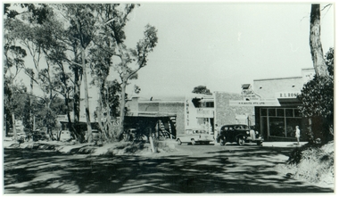
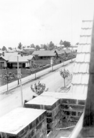
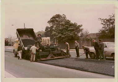 Kew Historical Society Inc
Photograph - Studley Park Road Reconstruction, 1968
One of a series of photographs donated by the City Engineer of the former City of Kew, relating to road works. The photos variably include council workers, signage and equipment.One of a series of photographs of core local government services as practised by the City of Kew. The photographs are an accurate record of street works of the period. This example is one of the few shot in colour in the 1960s. Original colour photographic positive of roadworks in Studley Park Road in the former City of Kew. A tip truck carrying bitumen unloads it contents on the road which is then levelled by a tray. Road workers supervise the road making. "STUDLEY PARK ROAD RECONSTRUCTION / 1 1/2" NOM [sic] SIZE BIT BINDER COURSE / JANUS CONSTRUCTIONS / 9TH OCT 1968"city of kew, local government -- city of kew, road works, street works, studley park road -- kew (vic.) -
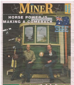 Ballarat Tramway Museum
Newspaper, The Miner, "Horse Power is Making a Comeback", 22/01/2015 12:00:00 AM
Newspaper clipping from The Miner, Thursday 22/1/2015 with the headline "Horse Power is Making a Comeback" on the front cover with Peter Waugh and Roger Gosney (holding Missy) sitting on the front bumper bar of No. 39 in the depot. On page 2 has a story titled "Turning back time lake tram service". Note the operation of the horse tram on 25/1/15, and general story about the tramway museum. On the back page has an advertisement for horse tram operation on 25/1/15.btm, horse tram, depot, displays, advertisements -
 Surrey Hills Historical Society Collection
Photograph, Union Road looking west from the steeple of Holy Trinity Church, 1922, 1922
At the edge of the church roof and on the horizon is 'The Knoll' on the corner of Union Road and Wandsworth Road. To the left of this is 297 Mont Albert Road, home of the Michael Parer family and further left is "Quamby", home of the Sherar family. This is easily recognised by the square viewing tower located on the west wing of the house. The Sherar family owned 'Quamby' from 1900 until 1925, when it became Mosgiel Private Hospital. Norman Carter took many photos of Surrey Hills and Mont Albert in the 1920s; many associated with events and activities of the Church of England. Black and white photo of taken from the steeple of Holy Trinity Church, during its construction, across Union Road to the north-west. In the foreground immature street trees can be seen and an original telephone pole with white insulators. The street has formed paths and bluestone kerb and channelling. holy trinity anglican church, union road, the knoll, quamby, street trees, telegraph and light poles, mosgiel hospital -
![Booklet, Souvenir of Phillip Island [Cowes, Rhyll, Newhaven etc] and San Remo, Late 1920s. Post 1926](/media/collectors/4f729f5b97f83e0308601629/items/6462d05d551955aaca8bbecf/item-media/6462d125551955aaca8c0867/item-fit-380x285.jpg) Phillip Island and District Historical Society Inc.
Phillip Island and District Historical Society Inc.Booklet, Souvenir of Phillip Island [Cowes, Rhyll, Newhaven etc] and San Remo, Late 1920s. Post 1926
Broadbent's Official Road Guides Company took over George R. Broadbent's business in 1935. In 1963, it changed its name to Broadbent's Road Maps Pty. Ltd. Broadbent's company produced many maps, road and tourism guides of Australia.HistoricalSmall, beige coloured booklet with blue print and round photo of S.S.Alvina at Cowes jetty on cover. Advertisement for Westernport Steamer Service on rear page. Contains descriptions of main towns and places of interest. Also advertisements for guesthouses, businesses and tourist guides.Broadbent's Holiday Guide to Phillip Island and San Remo. [alternative title]tourist brochure, souvenir, broadbent's guides, phillip island accommodation, ferries, maps, guesthouses, hotels, shops -
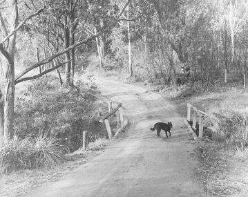 Ringwood and District Historical Society
Photograph, Deep Creek Road early 1900s
Black and white photograph of bend in unmade road. Bridge with black dog standing on bridge. Forest area on either side of road. (2 copies)Typed below photograph, "Deep Creek Road in early days". -
 Glen Eira Historical Society
Album - Album page, Booran Road, 30, Circa 1972
This photograph is part of the Caulfield Historical Album 1972. This album was created in approximately 1972 as part of a project by the Caulfield Historical Society to assist in identifying buildings worthy of preservation. The album is related to a Survey the Caulfield Historical Society developed in collaboration with the National Trust of Australia (Victoria) and Caulfield City Council to identify historic buildings within the City of Caulfield that warranted the protection of a National Trust Classification. Principal photographer thought to be Trevor Hart, member of Caulfield Historical Society. Most photographs were taken between 1966-1972 with a small number of photographs being older and from unknown sources. All photographs are black and white except where stated, with 386 photographs over 198 pages. From Glen Eira Heritage Management Plan 1996 by Andrew Ward: In 1888, John Leek, a trainer, owned Lot 15, measuring one and three quarter acres, in Booran Road, north side between Glen Eira and Neerim Roads. The land backed onto the Caulfield Racecourse Reserve. NAV was £45. In 1890 Leek built for his residence, a ten roomed brick house on the site. NAV was £200. Leek was the owner/trainer of "Ingliston" who won the Caulfield Cup in 1900. Upon the horse's death in 1901, Leek is understood to have defied tradition by spending £20 on boots for the "ragged urchins in Bourke Street" instead of "shouting" at the bar. By 1899, the property was owned and occupied by Alfred Merrill, a dentist and was known as "Andover". NA V had decreased to £ll0. By 1910, Leslie Macdonald, a gentleman had purchased the property and renamed it "Moidart". In 1910-11 Macdonald sold it to John Robertson. The property had extensive wood stables on its north-east boundary and several other outbuildings. The house continued to be described as "Brick, ten rooms" as it was in 1926 when it was owned and occupied by John Arthur, a managing director. The land measured la.2r.31p. and had a NAV of £235. Nine people lived there. In 1926, Arthur also owned the adjoining Lot 16. Other racehorses of note, known to have been stabled here include Sobar, Havelock, Proud, Future and Lord.Victorian Heritage Register https://vhd.heritagecouncil.vic.gov.au/places/13532 What is significant? Lord Lodge is a thoroughbred racehorse training complex adjacent to Caulfield Racecourse, established in 1890. The area immediately around the racecourse has been associated with horse racing activities and businesses servicing the industry since the development of the racecourse in late the 19th century. Lord Lodge was named by the present occupants after the champion racehorse Lord who was stabled there in the 1950s. In the early 20th century the property was known as 'Andover' and subsequently 'Moidart'. The site consists of a single storey brick Italianate villa, jockeys' quarters, stables and open day yards with direct access to Caulfield racecourse from the rear of the property. The villa of 10 rooms on bluestone foundations was constructed in 1890 by John Leek, a horse trainer who purchased the newly subdivided land in 1888. The house has many Victorian Italianate or Boom Style features although it is more modest than many villas of its style. It has an asymmetrical facade with a faceted bay window and a prominent central tower with low pitch pyramidal roof that provides a clear view of the racecourse. Other characteristic features include stilted segmented arches, bracketed eaves, stucco wall finish and cast cement ornamentation. A room has been added on the north-facing verandah in sympathetic style and finish. Internally the rooms are substantially intact with original marble fireplaces and intricate ceiling roses and cornices. An entrance toward the rear of the southern side of the house is said to be where the stable hands, jockeys and other staff lined up for their meals. In the southeast corner of the property, backing directly on to Caulfield racecourse, is a substantial late Victorian timber stable, probably constructed in the 1890s but first appearing on the property title in 1910. The stable has 12 stalls, a loft and brick pavement and jerkin head roof form with varnished pine-lined ceiling carried on a chamfered timber frame. It has an original roof lantern. The doors of the stalls are not the original sliding doors but swing doors obtained from a barn at Epsom Racecourse in Mordialloc prior to demolition. Outside the gambrel roof has fretted barges but the building is otherwise utilitarian. Timber throughout the stalls has been worn by chewing and rubbing of horses over the century of its use. In the southern half of the property are open day yards where the racehorses are kept during the day. The red brick, single storey jockeys' quarters to the rear of the villa were probably built around 1950. A small brick, possibly late Victorian structure on the eastern boundary thought to have originally been a gardening shed, has been converted to a stable of two stalls. Modern concrete brick stables fill the northeast portion of the property. At the front of the property two Moreton Bay Figs (Ficus macrophylla), probably planted in the late 19th century, provide shade for horses in the day yards. In the 1890s John Leek sold the property, relocating his training facility to one of the newly established racecourses at Mentone or Mordialloc (Epsom). By 1899, the property was owned and occupied by Alfred Merrill, a dentist, who named the property 'Andover'. In 1910 it was purchased by Leslie McDonald, a gentleman, and renamed 'Moidart'; sold in 1910-1911 to John Robertson; and again in 1926 to John Arthur, a racehorse owner. The Victorian Amateur Turf Club purchased the property in the late 1930s and since this time has been leased to racehorse trainers. It is unclear whether the property operated as a training facility between 1899 - 1926. Several notable trainers and jockeys are associated with Lord Lodge. The best known is Arthur 'Scobie' Breasley, Australia's most successful jockey who was apprenticed to trainer Pat Quinlan at Lord Lodge (then 'Moidart') from 1928 - 1935. Breasley rode winners of the Caulfield Cup in four successive years 1942-45 and again in 1952. John Leek, the original owner of Lord Lodge trained Ingliston, the 1900 Caulfield Cup winner. Along with 'Lord' a number of well known racehorses including Sobar, Havelock, Proud and Future were trained at Lord Lodge .....Page 40 of Photograph Album with three landscape photographs of the exterior of this house.Handwritten: 30 Booran Road [top right hand corner] / 40 [bottom right]trevor hart, jenny o'donnell, booran road, mansion, caulfield east, ingliston, sobar, havelock, proud, future, lord, andover, moidart, lord lodge, grace darling, caulfield racecourse reserve, victorian amateur turf club, historic buildings register, national estate register, caulfield cup, horses, stables, horse racing, racehorses, outbuildings, racehorse trainers, depression, 1890s, brick houses, mansions, towers, verandahs, stained glass, italianate style, victorian style, architectural features, architectural styles, john leek, leslie macdonald, john arthur, john robertson, alfred merrill, jenny odonnell -
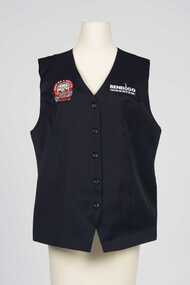 City of Greater Bendigo - Civic Collection
Uniform - Vest
Part of a uniform worn by staff and volunteers at the Visitor Centre at the Old Bendigo Post Office for the duration of the exhibition Making a Nation which closed in 2011.Navy blue vest with embroidered Making a National patch on upper right and Bendigo Tourism on upper left front. Five buttons on front.r; Making A Nation / Federation Exhibition / 1901 / Sir John Quick / BENDIGO l; Bendigo Tourismbendigo tourism, bendigo post office -
 Whitehorse Historical Society Inc.
Photograph, Footbridge Whitehorse Road, 1/06/1999 12:00:00 AM
Coloured photo - From Footbridge in Whitehorse Road, Mitcham, looking towards Mitcham Road.whitehorse road, overhead powerlines -
 Whitehorse Historical Society Inc.
Photograph, Whitehorse Road Footbridge, 1/06/1999 12:00:00 AM
Coloured photo - From Whitehorse Road Footbridge in Mitcham, looking towards Rooks Road.whitehorse road, overhead powerlines -
 Camberwell Historical Society
Photograph, Camberwell, Victoria, view of Burke Road and stores, c. 1950
Print of photograph looking north up Burke Road, with Rivoli Cinema on the right. Inscription 'Camberwell, Victoria, view of Burke Road and stores c. 1950' Camberwell, Victoria, view of Burke Road and stores c. 1950camberwell -
 Ringwood and District Historical Society
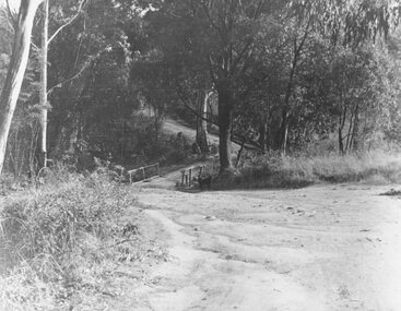
Photograph, Deep Creek Road bridge early 1900s
Black and white photograph taken from unmade road. Road zigzags over bridge with wooden balustrades. Bushland setting. (3 copies)Typed below photograph, "Deep Creek Road bridge in the early days". -
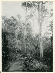
 Southern Sherbrooke Historical Society Inc.
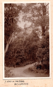
Photograph, A Bend In The Road, Belgrave, c. 1920s
Photo shows a bend in the road, Belgrave, most likely on Monbulk Road below Sherbrooke Forest. An unmade road crosses a small gully. A group of three or so young people are leaning over the bridge railing. The area is heavily treed. A BEND IN THE ROAD hand-wriiten in ink below the photo on the album page