Showing 344 items
matching roof tile
-
 Bendigo Historical Society Inc.
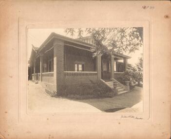
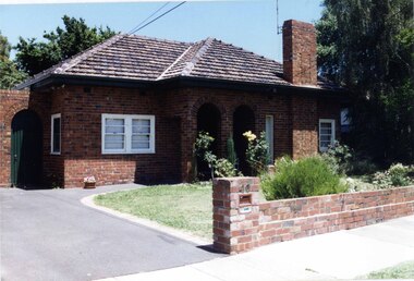
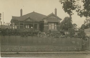
Photograph - BRICK HOUSE WITH BRICK VERANDAH
... verandah (and brick verandah posts). Tiled roof. Inscriptions... verandah posts). Tiled roof. Inscriptions: on front - 'MP 89 ...Black and white photograph of brick house with brick verandah (and brick verandah posts). Tiled roof. Inscriptions: on front - 'MP 89', 'Vincent Kelly, Bendigo', 'taken from inside of front gate'. On back - RHSV stamp, 'TC Watts' stamp, 'McGibbony's'. History: Previous Reg. No. MP89. Part of a collection of photographs used by estate agent TC Watts & Son, Bendigo to show potential purchasers.Vincent Kelly, Bendigobuildings, residential, brick house -
 Surrey Hills Historical Society Collection
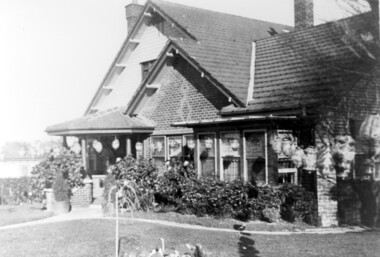
Photograph, Home and surgery of Dr William Langley Carrington, 174 Union Road, 1935
... , of brick construction with a tiled roof and front porch. It has.... The building is 2 storey, of brick construction with a tiled roof ...The building was erected in c 1913 as a home / surgery for Dr James L Blakie (1868-1937), who originally lived / practised across the road. It was designed by architect Arthur William Plaisted (1890-1965) and is an early example of attic-style Californian bungalow style. Dr Carrington ( 1900-1970) succeeded Dr Blakie and practised at 174 Union Road from 1930-1970. Now known as the Surrey Hills Medical Centre.Black and white photo of the surgery and home of Dr and Mrs William Langley Carrington at 174 Union Road on the corner of Guildford Road, Surrey Hills.. The exterior of the building is decorated with paper lanterns around the windows and veranda for the Empire Day celebrations in 1935. The building is 2 storey, of brick construction with a tiled roof and front porch. It has a bay window front right. Shadows indicate the photo was taken early morning in winter.medical services, guildford road, union road, dr william langley carrington, mr arthur plaisted, dr james landells blakie, californian bungalow, dr bill carrington -
 Glen Eira Historical Society
Photograph, Beauville Avenue, 35, Murrumbeena, 2001
... include a wide arched porch, tiled roof and low unpainted brown... a wide arched porch, tiled roof and low unpainted brown brick ...Originally labelled "Beauville Estate, Established 1936, Still Thriving 65 years on, 10th March 2001", the Beauville Estate Album contains colour photographs of houses in the Estate. They were taken around the time of the Beauville Estate’s 65th Heritage Celebration held on 10/03/2001 and donated to the Caulfield Historical Society shortly afterwards. Photographer unknown. Windows frames, gutters and drain pipe all painted black but this is same property as 2104A-39 where they are painted green.City of Glen Eira’s Heritage Management Plan Vol 2 p79 (this is p84 of the pdf version) – HO12 Beauville Estate and environs, Murrumbeena: The Beauville Historic Area is important at the State level as the first large housing estate undertaken by the AV Jennings Construction Co, later Jennings Group Limited, Victoria’s largest home builder. It is important also as a very early estate development incorporating a range of features other than houses and including made roads, shops and recreation facilities. In this respect it was the forerunner of the comprehensively planned housing estate of the post war era. The estate is distinguished by its aesthetic values, as is the earlier and comparable Hillcrest Estate, which are formed by a combination of restrained diversity in house styles, with the exception of no. 30 in the emerging International style, and by a landscaped garden environment. See Significance Statement in Glen Eira’s Heritage Management Plan by Andrew Ward (1996) Vol 2 p.79. Available from https://www.gleneira.vic.gov.au/media/4779/heritage_management_plan_volume_2.pdf (Note see p.84 of pdf)Colour photograph of white rendered house with unpainted variegated brown brick features including a geometric pattern of 3 vertical shapes on the gable over the porch. Other features include a wide arched porch, tiled roof and low unpainted brown brick fence in the foreground with "35" on the reddish brown metal letterbox on top of the brick pillar beside the driveway. Garage has a matching brown brick feature wall.murrumbeena, houses, beauville avenue, architectural styles, 1930's, inter war style, a.v. jennings, av jennings, jennings, brick houses, beauville estate, porches, letterboxes, sir albert victor jennings, a v jennings construction co, beauville estate heritage area, glen eira city council, architectural features, jennings group limited, land subdivision, gardens, beauville historic area, rendered houses, brick features, arches, brick fences, garages (private), gables -
 Stawell Historical Society Inc
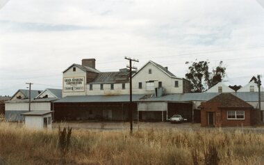
Photograph, Wimmera Flour Mill during Demolition -- Coloured
... with a tiled roof in these coloured photos. The rail line is shown... with a tiled roof in these coloured photos. The rail line is shown ...Various colour photos of Wimmera Flour Mill at time it was being demolished. Note roof being dismantled. Rail line in foreground. Willaim Frayne founded the Wimmera Flour Mill on a site in Taylor Street (beside the railway line) Stawell 1876. When Willian Frayne dies 1899 his son George took over the mill. The mill continued to be a propriety company until early 1966, when it was sold to the Victorian Mill Owners. The sale was forced because of the lack of export markets. A factor which affected most country mills. The Victorian Oat Growers Pool took over on July 1st, 1967. Trading under the name of Wimmera Flower Mill as a subsidiary company. Later years it sold clipped and graded seed, oats, stockfeed for poultry, pigs and dairy cattle and all types of crushed grain. The original Frayne homestead still stands behind where the Mill stood facing Frayne Street. In 2007 during our "Collection Review" the four smaller colour photos, which were donated by Mr. Mick Walsh, 52 Patrick St Stawell were very similar to the bigger photo in the file 139.6e.139-6 a-d & e Coloured photographs showing various views of the Wimmera Flour Mill or Grain Handling Corporation building in progress of being demolished. There is a red brick building with a tiled roof in these coloured photos. The rail line is shown in foreground of 139-6 e. Our records on the data base show 139-6e to be a black & white photo but the same photo in the office folder is an enlarged colour photograph. Grain Handing Corporation stawell industry -
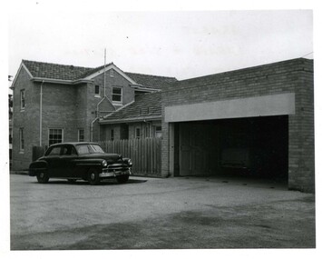
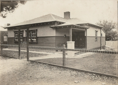 Bendigo Historical Society Inc.
Photograph - T C WATTS & SON COLLECTION: MILLER STREET, BENDIGO, 1929
... tile window. Leadlight windows and door central chimney tiled... tiled roof. On front of photo: Frank A. Jeffree, Photo, Bendigo ...BHS CollectionBlack and white photograph mounted on rectangular grey board. House, Double fronted wood and stucco bungalow style house with entry porch on R.H.S of dwelling with small porthole tile window. Leadlight windows and door central chimney tiled roof. On front of photo: Frank A. Jeffree, Photo, Bendigo. On back of photo: Mr. Simmonds, Miller St., £875 sewered. T.C. Watts & Son, Bendigo. 12 April 1929.Frank A. Jeffree Photo Bendigoplace, building, residential -
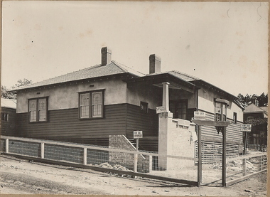 Bendigo Historical Society Inc.
Photograph - T C WATTS & SON COLLECTION: CORNER BOOTH AND OLD HIGH STREET, GOLDEN SQUARE, BENDIGO, 1930
... rendered, tiled roof, two chimneys visible, leadlight windows... portion rendered, tiled roof, two chimneys visible, leadlight ...BHS CollectionBlack and white photographs (2) mounted on rectangular brown board. House, weatherboard on lower portion, top portion rendered, tiled roof, two chimneys visible, leadlight windows, woven crinkled wire fence. 4 x For Sale signs displayed on house. On back of photo 'H. Simmons, £880 (crossed out) £980, Booth and Old High Street, sewered' 2012 photo of house attached to record.Frank A. Jeffree, Photo, Bendigobendigo, business, t c watts and son -
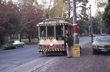 Ballarat Tramway Museum
Slide - 35mm slide/s - set of 3, David Verrier, 25/04/1975 12:00:00 AM
... - with a SEC and Eureka Tiles roof advertisement. Photo by David... - with a SEC and Eureka Tiles roof advertisement. Photo by David ...Yields information about the appearance of BTPS trams at the time of the first COTMA conference in 1975.Agfa colour slide, white blue plastic mount. Photograph Friday 25/4/1975 at the time of the first COTMA conference. Photos of trams 27 and 40 in Wendouree Parade. .1 - at depot junction, tram 27 has a Twin Lake sign, BTPS tram ride sign and Bill Jessup standing alongside. .2 - 27 and 40. .3 - Tram 40 - with a SEC and Eureka Tiles roof advertisement. Photo by David Verrier.On back of slide in ink' "Friday 25/4/75, Ballarat 27, 40"tramways, trams, btps, wendouree parade, depot junction, cotma, tram 27, tram 40 -
 Glen Eira Historical Society
Photograph, Lindsay Avenue, 40-42, Murrumbeena, 2001
... in the photograph. The visible features include their tiled roofs, white... in the photograph. The visible features include their tiled roofs, white ...Originally labelled "Beauville Estate, Established 1936, Still Thriving 65 years on, 10th March 2001", the Beauville Estate Album contains colour photographs of houses in the Estate. They were taken around the time of the Beauville Estate’s 65th Heritage Celebration held on 10/03/2001 and donated to the Caulfield Historical Society shortly afterwards. Photographer unknown. See also 2104A-City of Glen Eira’s Heritage Management Plan Vol 2 p79 (this is p84 of the pdf version) – HO12 Beauville Estate and environs, Murrumbeena: The Beauville Historic Area is important at the State level as the first large housing estate undertaken by the AV Jennings Construction Co, later Jennings Group Limited, Victoria’s largest home builder. It is important also as a very early estate development incorporating a range of features other than houses and including made roads, shops and recreation facilities. In this respect it was the forerunner of the comprehensively planned housing estate of the post war era. The estate is distinguished by its aesthetic values, as is the earlier and comparable Hillcrest Estate, which are formed by a combination of restrained diversity in house styles, with the exception of no. 30 in the emerging International style, and by a landscaped garden environment. Colour photograph of the driveways, unpainted variegated brown brick garages and similar side gates (one white and square, the other arched and dark) of two unpainted variegated brown brick houses. The two houses and gardens are only partially included in the photograph. The visible features include their tiled roofs, white painted window frames and low unpainted variegated brown brick fences in the foreground with "40" on the brick pillar beside the driveway on the right.40murrumbeena, houses, architectural styles, 1930's, inter war style, a.v. jennings, av jennings, jennings, brick houses, beauville estate, porches, lindsay avenue, sir albert victor jennings, a v jennings construction co, beauville estate heritage area, glen eira city council, architectural features, jennings group limited, land subdivision, gardens, beauville historic area, arches, brick features, sash windows, brick fences, letterboxes, drives, garages (private) -
 Lakes Entrance Regional Historical Society (operating as Lakes Entrance History Centre & Museum)
Photograph, 2000 c
... Colour photograph of timber dwelling. Tiled gabled roof... Heritage Study Colour photograph of timber dwelling. Tiled gabled ...Second photo of front garden, stone fence with wrought iron inserts and stone pedestal with sundial.Colour photograph of timber dwelling. Tiled gabled roof, decorative stone work on chimney, stone front fence with wrought iron inserts. House renovated sometime during 1990's, aluminium framed windows installed replacing original timber sash windows, at 7 Williams Road, Lakes Entrance Victoriahouses, heritage study -
 Victoria Police Museum
Police Stations (Ararat)
... were located at 3 Ligar Street (brick veneer with a tile roof... were located at 3 Ligar Street (brick veneer with a tile roof ...Ararat is a city in south-west Victoria, Australia, about 198 kilometres west of Melbourne, on the Western Highway on the eastern slopes of the Ararat Hills and Cemetery Creek valley between Victoria's Western District and the Wimmera. It is named after Mount Ararat 10 kilometres south-west of the town. A police station opened in Ararat in 1859, though there was a police presence in the area formerly known as Cathcart, Canton Lead and later Mount Ararat. In 1861 staff consisted of 1 Superintendent, 2 Mounted Constables, 1 Sergeant 2nd class, 1 Senior Constable, 8 Constables. The police reserve was on land bounded by Ligar Street, Barkley Street, Ingor Street and High Street. In 1930 the police station was described as a six-room brick dwelling with a slate roof, situated on one quarter acre of land. There was also a bathroom, wash-house, pantry, office, muster room and quarters for a single constable, stables with three stalls, and a lock-up consisting of two six-person cells. Later residences were located at 3 Ligar Street (brick veneer with a tile roof); 32A High Street (brick veneer with tile roof); and 3 Tobin Street (wood with an iron roof). A new, purpose built police station was opened in October 2010 at 77 Barkly Street. The Ararat Police District was reformed into the Wimmera Police District in 1870. Ararat Police Station became part of "R" (Glenelg) District in January 1948 and "M" (Highlands/Wimmera) District from March 1990. A list of police stationed at Ararat from 1903 - 1930 is available from the Victoria Police Museum8 photos comprising: 7 black & white photos 1 colour photopolice stations; ararat police station -
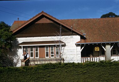
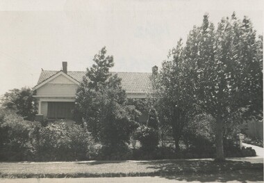 Surrey Hills Historical Society Collection
Photograph, 11 York Street, Mont Albert, 1962, 1974
... including a terracotta tiled roof, simple roof finials, simple... including a terracotta tiled roof, simple roof finials, simple ...This is the home of Ernest Lance Young and Beryl Mair and the childhood home of their children Barbara, Ken and Laurie. Lance was born 24 March 1915 in Surrey Hills, the son of Ernest Augustus Young and Ruby Nichell Whitby. He married Beryl Mair in 1939 and died on 5 October 1999 at Mont Albert. Electoral rolls list him as a manufacturer. His address after marriage was 11 York Street, Mont Albert. He is buried in Box Hill Cemetery (M-*-0867) along with his father. He served in WW2 (Service Number - VX104733 enlisting at St Kilda) and after returning took over his father's business. The Mair family were resident in Barton Street for several generations. Beryl's father Dave Mair was a keen sportsman and founder of the Kangaroo Social Club of cricketers. This is part of a large collection relating to the Mair, Deakin and Young families. Black & white photo of the street view of 11 York Street, Mont Albert. Although the house is heavily screened by a mature garden with several large trees or shrubs, part of the front can be seen. It is Californian bungalow in style with typical features including a terracotta tiled roof, simple roof finials, simple chimneys, shingle detail to the gable and brick and rounded pillar supports to the veranda. The front fence is low and constructed from roughly dressed stone.In black texta colour and black biro on rear: "1962 / 11 YORK ST/ MONT ALBERT" ken young, barbara young, laurie young, laurie newton, beryl mair, ernest lance young, lance young, york street, mont albert -
 Bendigo Historical Society Inc.
Photograph - T C WATTS & S0N COLLECTION: CORNER CONDON AND STERNBERG STREET, BENDIGO, 1928
... board. House, weatherboard and plaster, tile roof, arched entry..., tile roof, arched entry to porch, lattice work around, woven ...BHS CollectionBlack and white photograph mounted on rectangular grey board. House, weatherboard and plaster, tile roof, arched entry to porch, lattice work around, woven crinkled wire fence, 3 chimneys. Sticker on front ' August 1928, Condon and Sternberg Street, £1080 sewered' Written on back ' Mannic, H.E., Condon and Sternberg St., £1080 sewered, sold' Date stamp 25 August 1928. 2012 photo of house site is attached to record.Frank A. Jeffree, Bendigoplace, photo of house prepared for sale, residential, stamped on back in rectangle ''t.c. watts and son/auctioneer/estate agents/253 mitchell street/bendigo'' stamped on back in circle ''royal historical sociey of victoria, bendigo branch'' -
 Lakes Entrance Regional Historical Society (operating as Lakes Entrance History Centre & Museum)
Photograph, 1999
... , lathes over joins painted to represent mock Tudor. Clay tile hip... to represent mock Tudor. Clay tile hip roofs. Ground planted ...Built by Dud Conduit 1960c. Owners Bob & Karen Lewendon.Colour photograph of a group of two bedroom holiday cabins, known as Homelea Flats, with entrances from both Roadknight Street and Esplanade. Cabins and residence clad in fibro cement, lathes over joins painted to represent mock Tudor. Clay tile hip roofs. Ground planted with deciduous trees. Lakes Entrance Victoriawaterways, accommodation -
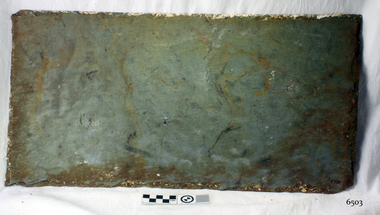
 Flagstaff Hill Maritime Museum and Village
Geological specimen - Slate, c. 1908
... with 56,763 tiles of unusual beautiful green American slates (roof... American slates (roof tiles), 5,673 coils of barbed wire, 600 ...The iron-hulled, four-masted barque, the Falls of Halladale, was a bulk carrier of general cargo. She left New York in August 1908 on her way to Melbourne and Sydney. In her hold, along with 56,763 tiles of unusual beautiful green American slates (roof tiles), 5,673 coils of barbed wire, 600 stoves, 500 sewing machines, 6500 gallons of oil, 14400 gallons of benzene, and many other manufactured items, were 117 cases of crockery and glassware. Three months later and close to her destination, a navigational error caused the Falls of Halladale to be wrecked on a reef off the Peterborough headland at 3 am on the morning of the 15th of November, 1908. The captain and 29 crew members all survived, but her valuable cargo was largely lost, despite two salvage attempts in 1908-09 and 1910. ABOUT THE ‘FALLS OF HALLADALE’ (1886 - 1908) Built: in1886 by Russell & Co., Greenock shipyards, River Clyde, Scotland, UK. The company was founded in 1870 (or 1873) as a partnership between Joseph Russell (1834-1917), Anderson Rodger and William Todd Lithgow. During the period 1882-92 Russell & Co., standardised designs, which sped up their building process so much that they were able to build 271 ships over that time. In 1886 they introduced a 3000 ton class of sailing vessel with auxiliary engines and brace halyard winches. In 1890 they broke the world output record. Owner: Falls Line, Wright, Breakenridge & Co, 111 Union Street, Glasgow, Scotland. Configuration: Four masted sailing ship; iron-hulled barque; iron masts, wire rigging, fore & aft lifting bridges. Size: Length 83.87m x Breadth 12.6m x Depth 7.23m, Gross tonnage 2085 ton Wrecked: the night of 14th November 1908, Curdies Inlet, Peterborough south west Victoria Crew: 29 The Falls of Halladale was a four-masted sailing ship built-in 1886 in Glasgow, Scotland, for the long-distance cargo trade and was mostly used for Pacific grain trade. She was owned by Wright, Breakenridge & Co of Glasgow and was one of several Falls Line ships, all of which were named after waterfalls in Scotland. The lines flag was of red, blue and white vertical stripes. The Falls of Halladale had a sturdy construction built to carry maximum cargo and able to maintain full sail in heavy gales, one of the last of the ‘windjammers’ that sailed the Trade Route. She and her sister ship, the Falls of Garry, were the first ships in the world to include fore and aft lifting bridges. Previous to this, heavily loaded vessels could have heavy seas break along the full length of the deck, causing serious injury or even death to those on deck. The new, raised catwalk-type decking allowed the crew to move above the deck stormy conditions. This idea is still used today on the most modern tankers and cargo vessels and has proved to be an important step forward in the safety of men at sea. On 4th August 1908, with new sails, 29 crew, and 2800 tons of cargo, the Falls of Halladale left New York, bound for Melbourne and Sydney via the Cape of Good Hope. The cargo on board was valued at £35,000 and included 56,763 tiles of American slate roof tiles (roof slates), 5,673 coils of barbed wire, 600 stoves, 500 sewing machines, 6,500 gallons of oil, 14,400 gallons of benzene, plumbing iron, 117 cases of crockery and glassware and many other manufactured items. The Falls of Halladale had been at sail for 102 days when, at 3 am on the night of 14th November 1908, under full sail in calm seas with a six knots breeze behind and misleading fog along the coast, the great vessel rose upon an ocean swell and settled on top of a submerged reef near Peterborough on the south-west Victoria’s coast. The ship was jammed on the rocks and began filling with water. The crew launched the two lifeboats and all 29 crew landed safely on the beach over 4 miles away at the Bay of Islands. The postmistress at Peterborough, who kept a watch for vessels in distress, saw the stranding and sent out an alert to the local people. A rescue party went to the aid of the sailors and the Port Campbell rocket crew was dispatched, but the crew had all managed to reach shore safely by the time help arrived. The ship stayed in full sail on the rocky shelf for nearly two months, attracting hundreds of sightseers who watched her slowly disintegrate until the pounding seas and dynamiting by salvagers finally broke her back, and her remains disappeared back into deeper water. The valuable cargo was largely lost, despite two salvage attempts in 1908-09 and 1910. Further salvage operations were made from 1974-1986, during which time 22,000 slate tiles were recovered with the help of 14 oil drums to float them, plus personal artefacts, ship fittings, reams of paper and other items. The Court of Marine Inquiry in Melbourne ruled that the foundering of the ship was entirely due to Captain David Wood Thomson’s navigational error, not too technical failure of the Clyde-built ship. The shipwreck is a popular site for divers, about 300m offshore and in 3 – 15m of water. Some of the original cargo can be seen at the site, including pieces of roof slate and coils of barbed wire. The Falls of Halladale shipwreck is listed on the Victorian Heritage Register (No. S255). She was one of the last ships to sail the Trade Routes. She is one of the first vessels to have fore and aft lifting bridges. She is an example of the remains of an International Cargo Ship and also represents aspects of Victoria’s shipping industry. The wreck is protected as a Historic Shipwreck under the Commonwealth Historic Shipwrecks Act (1976).Californian, American, rectangular blue roof slate, recovered from the wreck of the Falls of Halladale. flagstaff hill, warrnambool, shipwrecked-coast, flagstaff-hill, flagstaff-hill-maritime-museum, maritime-museum, shipwreck-coast, flagstaff-hill-maritime-village, falls of halladale, slate, roof slate, russell & co. -
 Flagstaff Hill Maritime Museum and Village
Geological specimen - Slate, c. 1908
... with 56,763 tiles of unusual beautiful green American slates (roof... with 56,763 tiles of unusual beautiful green American slates (roof ...The iron-hulled, four-masted barque, the Falls of Halladale, was a bulk carrier of general cargo. She left New York in August 1908 on her way to Melbourne and Sydney. In her hold, along with 56,763 tiles of unusual beautiful green American slates (roof tiles), 5,673 coils of barbed wire, 600 stoves, 500 sewing machines, 6500 gallons of oil, 14400 gallons of benzene, and many other manufactured items, were 117 cases of crockery and glassware. Three months later and close to her destination, a navigational error caused the Falls of Halladale to be wrecked on a reef off the Peterborough headland at 3 am on the morning of the 15th of November, 1908. The captain and 29 crew members all survived, but her valuable cargo was largely lost, despite two salvage attempts in 1908-09 and 1910. ABOUT THE ‘FALLS OF HALLADALE’ (1886 - 1908) Built: in1886 by Russell & Co., Greenock shipyards, River Clyde, Scotland, UK. The company was founded in 1870 (or 1873) as a partnership between Joseph Russell (1834-1917), Anderson Rodger and William Todd Lithgow. During the period 1882-92 Russell & Co., standardised designs, which sped up their building process so much that they were able to build 271 ships over that time. In 1886 they introduced a 3000 ton class of sailing vessel with auxiliary engines and brace halyard winches. In 1890 they broke the world output record. Owner: Falls Line, Wright, Breakenridge & Co, 111 Union Street, Glasgow, Scotland. Configuration: Four masted sailing ship; iron-hulled barque; iron masts, wire rigging, fore & aft lifting bridges. Size: Length 83.87m x Breadth 12.6m x Depth 7.23m, Gross tonnage 2085 ton Wrecked: the night of 14th November 1908, Curdies Inlet, Peterborough south west Victoria Crew: 29 The Falls of Halladale was a four-masted sailing ship built-in 1886 in Glasgow, Scotland, for the long-distance cargo trade and was mostly used for Pacific grain trade. She was owned by Wright, Breakenridge & Co of Glasgow and was one of several Falls Line ships, all of which were named after waterfalls in Scotland. The lines flag was of red, blue and white vertical stripes. The Falls of Halladale had a sturdy construction built to carry maximum cargo and able to maintain full sail in heavy gales, one of the last of the ‘windjammers’ that sailed the Trade Route. She and her sister ship, the Falls of Garry, were the first ships in the world to include fore and aft lifting bridges. Previous to this, heavily loaded vessels could have heavy seas break along the full length of the deck, causing serious injury or even death to those on deck. The new, raised catwalk-type decking allowed the crew to move above the deck stormy conditions. This idea is still used today on the most modern tankers and cargo vessels and has proved to be an important step forward in the safety of men at sea. On 4th August 1908, with new sails, 29 crew, and 2800 tons of cargo, the Falls of Halladale left New York, bound for Melbourne and Sydney via the Cape of Good Hope. The cargo on board was valued at £35,000 and included 56,763 tiles of American slate roof tiles (roof slates), 5,673 coils of barbed wire, 600 stoves, 500 sewing machines, 6,500 gallons of oil, 14,400 gallons of benzene, plumbing iron, 117 cases of crockery and glassware and many other manufactured items. The Falls of Halladale had been at sail for 102 days when, at 3 am on the night of 14th November 1908, under full sail in calm seas with a six knots breeze behind and misleading fog along the coast, the great vessel rose upon an ocean swell and settled on top of a submerged reef near Peterborough on the south-west Victoria’s coast. The ship was jammed on the rocks and began filling with water. The crew launched the two lifeboats and all 29 crew landed safely on the beach over 4 miles away at the Bay of Islands. The postmistress at Peterborough, who kept a watch for vessels in distress, saw the stranding and sent out an alert to the local people. A rescue party went to the aid of the sailors and the Port Campbell rocket crew was dispatched, but the crew had all managed to reach shore safely by the time help arrived. The ship stayed in full sail on the rocky shelf for nearly two months, attracting hundreds of sightseers who watched her slowly disintegrate until the pounding seas and dynamiting by salvagers finally broke her back, and her remains disappeared back into deeper water. The valuable cargo was largely lost, despite two salvage attempts in 1908-09 and 1910. Further salvage operations were made from 1974-1986, during which time 22,000 slate tiles were recovered with the help of 14 oil drums to float them, plus personal artefacts, ship fittings, reams of paper and other items. The Court of Marine Inquiry in Melbourne ruled that the foundering of the ship was entirely due to Captain David Wood Thomson’s navigational error, not too technical failure of the Clyde-built ship. The shipwreck is a popular site for divers, about 300m offshore and in 3 – 15m of water. Some of the original cargo can be seen at the site, including pieces of roof slate and coils of barbed wire. The Falls of Halladale shipwreck is listed on the Victorian Heritage Register (No. S255). She was one of the last ships to sail the Trade Routes. She is one of the first vessels to have fore and aft lifting bridges. She is an example of the remains of an International Cargo Ship and also represents aspects of Victoria’s shipping industry. The wreck is protected as a Historic Shipwreck under the Commonwealth Historic Shipwrecks Act (1976).Californian American rectangular blue roof slate, recovered from the wreck of the Falls of Halladale. flagstaff hill, warrnambool, shipwrecked-coast, flagstaff-hill, flagstaff-hill-maritime-museum, maritime-museum, shipwreck-coast, flagstaff-hill-maritime-village, californian blue roof slate, falls of halladale., californian blue roof slate, green american slate, slate, russell & co. -
 Ballarat Tramway Museum
Photograph - Colour Photograph/s, David Endacott, 1971
... . Not the same tram as on 1279 or 1280 as it has a SEC and Eureka Tiles.... Not the same tram as on 1279 or 1280 as it has a SEC and Eureka Tiles ...Colour print of a Ballarat single trucker en route for the Gardens, just past St Aidans Drive during Winter 1971. Photo taken from partly within Lake Wendouree, looking at the tramcar through the trees, which has passed the photographer. See also Reg Nos. 1279 and 1280 for related images. On Kodak paper. Not the same tram as on 1279 or 1280 as it has a SEC and Eureka Tiles roof ad. Original film image scanned at 3200dpi 12/5/2020.On rear in blue ink "Lake Wendouree" and in top left hand corner "1971".ballarat, lake wendouree, st aidans drive -
 Glen Eira Historical Society
Photograph, Beauville Avenue, 34, Murrumbeena, 2001
... a wide arched porch, tiled roof, tall brick chimney, cast iron... a wide arched porch, tiled roof, tall brick chimney, cast iron ...Originally labelled "Beauville Estate, Established 1936, Still Thriving 65 years on, 10th March 2001", the Beauville Estate Album contains colour photographs of houses in the Estate. They were taken around the time of the Beauville Estate’s 65th Heritage Celebration held on 10/03/2001 and donated to the Caulfield Historical Society shortly afterwards. Photographer unknown.City of Glen Eira’s Heritage Management Plan Vol 2 p79 (this is p84 of the pdf version) – HO12 Beauville Estate and environs, Murrumbeena: The Beauville Historic Area is important at the State level as the first large housing estate undertaken by the AV Jennings Construction Co, later Jennings Group Limited, Victoria’s largest home builder. It is important also as a very early estate development incorporating a range of features other than houses and including made roads, shops and recreation facilities. In this respect it was the forerunner of the comprehensively planned housing estate of the post war era. The estate is distinguished by its aesthetic values, as is the earlier and comparable Hillcrest Estate, which are formed by a combination of restrained diversity in house styles, with the exception of no. 30 in the emerging International style, and by a landscaped garden environment. Colour photograph of white rendered, corner house with unpainted variegated brown brick features. Other features include a wide arched porch, tiled roof, tall brick chimney, cast iron work black porch door, window awnings and low unpainted matching brick fence in the foreground with "34" on the white metal letterbox on top of the right brick pillar beside the concrete pathway leading to the porch. Well-established garden including 2 matching pencil pines.murrumbeena, houses, beauville avenue, architectural styles, 1930's, inter war style, a.v. jennings, av jennings, jennings, brick houses, beauville estate, porches, sir albert victor jennings, a v jennings construction co, beauville estate heritage area, glen eira city council, architectural features, jennings group limited, land subdivision, gardens, beauville historic area, rendered houses, corner houses, brick features, awnings, brick fences, metal letterboxes, trees, cast iron work door -
 Glen Eira Historical Society
Photograph, Beauville Avenue, 35, Murrumbeena, 2001
... include a wide arched porch, tiled roof and low unpainted reddish... a wide arched porch, tiled roof and low unpainted reddish brown ...Originally labelled "Beauville Estate, Established 1936, Still Thriving 65 years on, 10th March 2001", the Beauville Estate Album contains colour photographs of houses in the Estate. They were taken around the time of the Beauville Estate’s 65th Heritage Celebration held on 10/03/2001 and donated to the Caulfield Historical Society shortly afterwards. Photographer unknown. Windows frames, gutters and drain pipe all painted green but this is same property as 2104A-38 where they are painted black.City of Glen Eira’s Heritage Management Plan Vol 2 p79 (this is p84 of the pdf version) – HO12 Beauville Estate and environs, Murrumbeena: The Beauville Historic Area is important at the State level as the first large housing estate undertaken by the AV Jennings Construction Co, later Jennings Group Limited, Victoria’s largest home builder. It is important also as a very early estate development incorporating a range of features other than houses and including made roads, shops and recreation facilities. In this respect it was the forerunner of the comprehensively planned housing estate of the post war era. The estate is distinguished by its aesthetic values, as is the earlier and comparable Hillcrest Estate, which are formed by a combination of restrained diversity in house styles, with the exception of no. 30 in the emerging International style, and by a landscaped garden environment. Colour photograph of white rendered house with unpainted variegated brown brick features including a geometric pattern of 3 vertical shapes on the gable over the porch. Other features include a wide arched porch, tiled roof and low unpainted reddish brown brick fence in the foreground with "35" on the reddish brown metal letterbox on top of the brick pillar beside the driveway. There are low, red, wrought iron gates across the driveway entrance. Garage has a matching brown brick feature wall.murrumbeena, houses, beauville avenue, architectural styles, 1930's, inter war style, a.v. jennings, av jennings, jennings, brick houses, beauville estate, porches, letterboxes, sir albert victor jennings, a v jennings construction co, beauville estate heritage area, glen eira city council, architectural features, jennings group limited, land subdivision, gardens, beauville historic area, rendered houses, brick features, arches, brick fences, garages (private), gables -
 Glen Eira Historical Society
Photograph, Lindsay Avenue, 40, Murrumbeena, 2001
... a long narrow white window to right of the porch, tiled roof... a long narrow white window to right of the porch, tiled roof ...Originally labelled "Beauville Estate, Established 1936, Still Thriving 65 years on, 10th March 2001", the Beauville Estate Album contains colour photographs of houses in the Estate. They were taken around the time of the Beauville Estate’s 65th Heritage Celebration held on 10/03/2001 and donated to the Caulfield Historical Society shortly afterwards. Photographer unknown. City of Glen Eira’s Heritage Management Plan Vol 2 p79 (this is p84 of the pdf version) – HO12 Beauville Estate and environs, Murrumbeena: The Beauville Historic Area is important at the State level as the first large housing estate undertaken by the AV Jennings Construction Co, later Jennings Group Limited, Victoria’s largest home builder. It is important also as a very early estate development incorporating a range of features other than houses and including made roads, shops and recreation facilities. In this respect it was the forerunner of the comprehensively planned housing estate of the post war era. The estate is distinguished by its aesthetic values, as is the earlier and comparable Hillcrest Estate, which are formed by a combination of restrained diversity in house styles, with the exception of no. 30 in the emerging International style, and by a landscaped garden environment. Colour photograph of an unpainted variegated brown brick house. Other features include a porch with two arches and separate rectangular entry from the path, arched side gate in a wall attached to the house at the side of the drive, feature work on all arches and chimney, white framed sash windows plus a long narrow white window to right of the porch, tiled roof, tall and wide chimney and low unpainted brick fence in the foreground with "40" on the brick pillar beside the drive.40murrumbeena, houses, architectural styles, 1930's, inter war style, a.v. jennings, av jennings, brick houses, beauville estate, porches, lindsay avenue, sir albert victor jennings, a v jennings construction co, beauville estate heritage area, glen eira city council, architectural features, jennings group limited, land subdivision, gardens, beauville historic area, jennings, arches, chimneys, brick features, sash windows, brick fences -
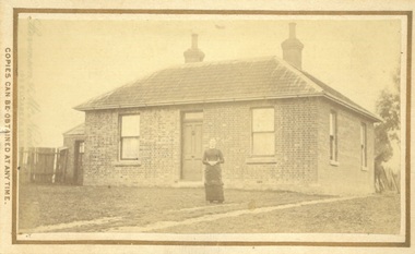 Bacchus Marsh & District Historical Society
Photograph, James Reid House Bacchus Marsh 1883
... there is a smaller room with its own entry door. The main roof is tiled... roof is tiled with shingles or slate and features two ...James Reid was born in Scotland near Glasgow and came to Victoria as a young man in 1854. Shortly after arriving he came to Bacchus Marsh where he lived until his death in 1902 at the age of 74 years. For most of these years he conducted a wheelwrights and coach builders business in Bacchus Marsh. In the nineteenth and early twentieth centuries, wheelwrights and blacksmiths played an essential role in the functioning of the whole community. Before the industrialisation of manufacturing, wheels and other components of vehicles for transport, all metal objects, including farm implements, building requirements and domestic utensils were made by hand. As mechanisation of industry increased, the smith commonly performed the role of farrier in the times when horse power was pivotal to all aspects of society. Small sepia unframed photograph on card with gold border framing photograph. Housed in the album, 'Photographs of Bacchus Marsh and District in 1883 by Stevenson and McNicoll' The photo shows a plain brick house with a central front door with a window on either side. There are a further two windows along the side of the house. On the left-hand side of the building there is a smaller room with its own entry door. The main roof is tiled with shingles or slate and features two substantial chimneys. At the front of the house stands a young woman with her hands clasped. A horse can be seen at the rear of the house. From the photo of the James Reid Wheelwright and Blacksmith Shop, Victorian Collections No.VC 618, we know that this house stood to the rear of the workshop. The wheel tracks which can be seen lead out to Main Street. On the front: Stevenson & McNicoll. Photo. 108 Elizabeth St. Melbourne. COPIES CAN BE OBTAINED AT ANY TIME. On the back: LIGHT & TRUTH inscribed on a banner surmounted by a representation of the rising sun. Copies of this Portrait can be had at any time by sending the Name and Post Office Money Order or Stamps for the amount of order to STEVENSON & McNICOLL LATE BENSON & STEVENSON, Photographers. 108 Elizabeth Street, MELBOURNE houses bacchus marsh, stevenson and mcnicoll 1883 photographs of bacchus marsh and district, james reid 1828?-1902, wheelrights bacchus marsh -
 Surrey Hills Historical Society Collection
Photograph - Digital photograph, George L Coop, 688 Whitehorse Road, Mont Albert 1958, 1958
... weatherboard in a Californian bungalow style with a tiled roof... is white weatherboard in a Californian bungalow style with a tiled ...The gentleman in the photo is George Burton Coop, an architect / draughtsman. The donor, his son George Lister Coop was about 21 years of age when he took this photo in 1958 of his family home. His parents were: George Burton Coop (b c1906 Williamstown; died aged 54 years at Mont Albert) and Winsome Alice (MS: Trewartha) who married in 1936. They are first listed at this address in the electoral roll in 1937. They had 2 children: George Lister Coop - born St Georges Hospital, 8/10/1937 and Alison - born c1945. However the donor informed that he initially attended Chatham State School because his first home was the Spanish Mission style flats at 346 Whitehorse Road, opposite Brenbeal Street, Balwyn. When his grandparents died, the family moved to 688 Whitehorse Road and he then attended Mont Albert Central School. Alison being younger did not go to Chatham Primary. A digital copy of a colour photo showing detail of the front view of 688 Whitehorse Road. The house is white weatherboard in a Californian bungalow style with a tiled roof and shingles detail in a dark brown stain. The balustrades and finials of the veranda are simple with occasional feature planks with a tulip detail. A bird cage hangs from the veranda. The veranda is supported by rough-cast sturdy pillars. The house sits behind a cypress hedge. The photo was taken in winter as deciduous shrubs are bare. A gentleman astride a ladder is pruning the hedge. george l coop, whitehorse road, mont albert, californian bungalow, cypress hedge, gardening, george burton coop -
 Bendigo Historical Society Inc.
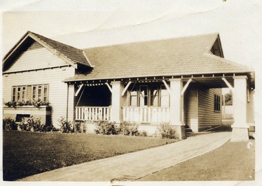
Photograph - HOUSE & HORSE & BUGGY
... Small photograph of a weatherboard house with a tiled roof... with a tiled roof. The house has an unequal gable, a veranda ...Small photograph of a weatherboard house with a tiled roof. The house has an unequal gable, a veranda at the front and part way down one side which is made into a room. It has the same roof material as the house. At the back is a large chimney just above gable height. There are some short shrubs at the side of the house and a picket fence with a girl standing in front of it. In front of the house is the horse and buggy with the family sitting in it. In the foreground is the driveway and some shrubs. Photo mounted on white card with a gold border and photographer's name faintly on the back in pink.? Baume, 5 Collins St., Melbournebuildings, house, homes, house & horse & buggy, ? baume -
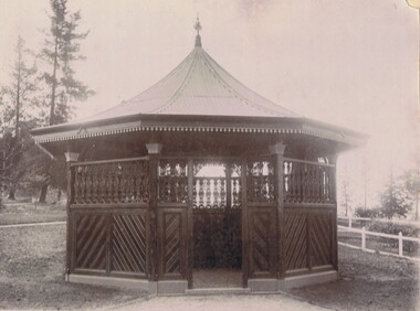
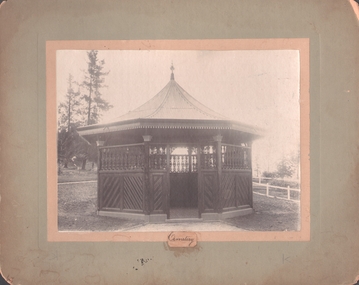 Bendigo Historical Society Inc.
Photograph - WHITEHILLS CEMETERY ROTUNDA
... . Decorative finial to roof line. Tessellated tiles on floor. White... work on eaves. Decorative finial to roof line. Tessellated ...B+W Photo on fawn board. Ornate Rotunda. Diagonal timber insert on bottom. Cast iron lace on top and lace work on eaves. Decorative finial to roof line. Tessellated tiles on floor. White fence on right side. Inscription: On front at bottom of image, !.3 x 2 cm piece of paper glued to board, hand written 'Cemetery'. On back, hand written in ballpoint pen, 'Royal Historical Society of Vic./Bendigo Branch', 'Rotunda/1204/FSP.'. Research: Rotunda at White Hills Cemeteryplace, cemetery, rotunda -
 Bendigo Historical Society Inc.
Photograph - WHITE HILLS CEMETERY VICTORIAN ROTUNDA, 1890's
... . Decorative finial to roof line. Tessellated tiles on floor. White.... Decorative finial to roof line. Tessellated tiles on floor. White ...B+W Photo on fawn board. Ornate Rotunda. Diagonal timber insert on bottom. Cast iron lace on top and lace work on eaves. Decorative finial to roof line. Tessellated tiles on floor. White fence on right side. Inscription: On front at bottom of image, !.3 x 2 cm piece of paper glued to board, hand written 'Cemetery'. On back, hand written in ballpoint pen, 'Royal Historical Society of Vic./Bendigo Branch', 'Rotunda/1204/FSP.'. Research: Rotunda at White Hills Cemeterybuildings -
 Bendigo Historical Society Inc.
Postcard - ROY AND DORIS KELLY COLLECTION: VERCLAU, POSTCARD, 1900-1920
... Postcard, B&W image of a tiled roof, brick house behind... Postcard, B&W image of a tiled roof, brick house behind a picket ...Postcard, B&W image of a tiled roof, brick house behind a picket fence and front lawn and flower garden. A woman stands on the front verandah and a man stands to the right of the steps up to the house. Front gate from a footpath at lower right. On the back handwritten in ink ' 1916-1917 Season's Greetings from "Verclau" Also an oval shaped stamp inside reads 'A Aberline 138 Glenferrie Rd Glenferrie' 'Verclau' is the name of the house in Stevenson St, Kew, Melbourne. According to a press death notice a family called GUY was living there in 1917.postcard, photograph, postcard, verclau, house, stevenson st, kew -
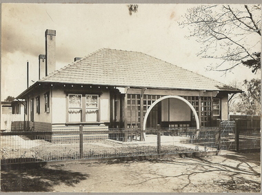
 Kew Historical Society Inc
Photograph - 8 roomed DF Brick Villa, Kew, J E Barnes, c.1920
... of the house: "Kew, 3 minutes from tram, 8 roomed DF Brick Villa, tile... Villa, tile roof including two attics, sleepout, bathroom ...Subdivision plans are historically important documents used as evidence of the growth of suburbs in Australia. They frequently provide information about when the land was sold on which a built structure was subsequently constructed as well as evidence relating to surveyors and real estate and financial agents. The numerous subdivision plans in the Kew Historical Society's collection represent working documents, ranging from the initial sketches made in planning a subdivision to printed plans on which auctioneers or agents listed the prices for which individual lots were sold. In a number of cases, the reverse of a subdivision plan in the collection includes a photograph of a house that was also for sale by the agent. These photographs provide significant heritage information relating house design and decoration, fencing and household gardens. The photograph is of additional aesthetic significance as it was photographed by J. E. Barnes. Josiah Earl Barnes is a nationally significant photographer. He was also the most important photographer to have worked in Kew. He was active as a photographer in the district from c.1906 until his death in 1921. Best known as 'the Embarkation Photographer' (see the Australian War Memorial collection), J. Earl Barnes was also the official photographer employed by the Borough (and later Town, then City) of Kew. He clearly also completed commercial jobs for local businesses, as is the case in this photograph of a house for a local real estate and financial agent.A photograph, mounted on board of a double fronted Federation-era brick villa in Kew, photographed for a local real estate agent and financier by J. E. Barnes of Kew. On the reverse of the photograph is a subdivision plan for the Normanby Estate, East Kew - 2016.0039.1. As can be seen from the image, there is a large tear on the surface of the photograph.The brown card on which the photograph is mounted includes the following handwritten description, which may aid the identification of the house: "Kew, 3 minutes from tram, 8 roomed DF Brick Villa, tile roof including two attics, sleepout, bathroom, heater, E Light, Entrance Hall, double doors, leadlights, laundry, garden, lawns, land 75 x 170, 1975 pounds". Also photographers inscription on mount, lower left: J. E. Barnes / Photo / Phone 1966 Haw. KEW.j. e. barnes, josiah earl barnes, j. earl banes - photographer, architecture - federation style, houses - kew, real estate photographs -
 Surrey Hills Historical Society Collection
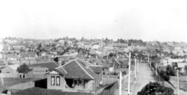
Photograph, Surrey Hills viewed from 'Quamby' at 293 Mont Albert Road, c 1915, 1915
... . In the centre foreground is a timber house with 2 chimneys and a tiled... is a timber house with 2 chimneys and a tiled hip roof. It has ...Quamby was built in 1898. From 1900/1903-1924 it was the home of Andrew Sherar and family. From 1924-1960s it operated as Mosgiel Hospital under the direction of Matron Elizabeth Anderson. Until Box Hill Hospital opened most Surrey Hills children were born at Mosgiel or at Nethercourt Hospital in Wilson Street or later in Union Road when Matron Tank moved her hospital here. Mosgiel Hospital was demolished c 1975 after it was sold by Box Hill Hospital. It was replaced by units. Andrew Sherar was conductor of the Wyclif Church choir for many years and was a member of the Melbourne Liedertafel. Isie Sherar was organist at Wyclif Church and also taught piano in Union Road. Connie Sherar was in the Wyclif choir and married Ernest Swan, an elocutionist and orator. Dorothy Sherar was a pianist and accompanist. Elsie Sherar was also in the Wyclif choir and was a soloist; she later moved to Templestowe. Ken Sherar was a boy soprano at St Paul's Cathedral; he later moved to Queensland.Black and white photo looking south down Vincent Street from 'Quamby', located at 293 Mont Albert Road, Surrey Hills. In the centre foreground is a timber house with 2 chimneys and a tiled hip roof. It has a return veranda and is fenced on 2 sides by paling fences and picket fences on the other two. In the background are many more houses. A road lined with power poles runs from the right foreground to the middle distance.quamby, vincent street, edwardian style, topography, andrew sherar, isie sherar, connie sherar, dorothy sherar, ken sherar, elsie wappet -
 Surrey Hills Historical Society Collection
Digital photo, George L Coop, 688 Whitehorse Rd. Mont Albert c1950, c1950
... with a terracotta tiled roof. There is a flower bed across the front... is weatherboard with a terracotta tiled roof. There is a flower bed across ...This was the home of 3 generations of the Coop family: 1. Josephine and George Frank Coop (noted in Box Hill Rate Books for 1947-1954). 2. George Burton Coop (1906-1960) and his family. He was Assistant Chief Architect of Victoria in the Public Works Department (P.W.D.) George Burton Coop was born in c1906 in Williamstown, the son of Josephine Vistarini and George Frank Coop. He married Winifred Alice Trewartha in 1936 and they are listed in the electoral rolls at 688 Whitehorse Road in 1937. George died 3/4/1960, aged 54 years at Mont Albert. 3. George Burton and Alice Coop had 2 children: George Lister Coop - born St Georges Hospital, 8/10/1937 Alison - born c1945. The donor George Lister Coop informed that he initially attended Chatham State School because his first home was the Spanish Mission style flats at 346 Whitehorse Road, opposite Brenbeal Street, Balwyn. When his grandparents died, the family moved to 688 Whitehorse Road and he then attended Mont Albert Central School. The California bungalow style of housing was the dominant style of housing built in the interwar period through the northern parts of Surrey Hills and Mont Albert as formerly semi-rural land was subdivided for new housing. It was relatively inexpensive and affordable. In Australia the Californian bungalow drew upon elements that were popular across the United States from around 1910 to 1939. In Australia the style became popular from 1913. In Melbourne both timber and red brick were used as the main building material. Typically they are one or one and a half story houses and feature sloping roofs and eaves with unenclosed rafters and often a feature a dormer window (or an attic vent designed to look like one) over the main portion of the house. Decorative elements include wood shingles, part stucco rendered exteriors, brick, stone, rendered or a combination of these treatments to exterior chimneys and front porches supported by heavy timber, brick or stucco columns.A sepia photo taken at an angle from the street corner of the property. It is of a Californian bungalow with a driveway that extends through a carport, attached and roofed as part of the house, to the rear of the property. The veranda is accessed from under this covered area. The veranda and carport are supported by brick pillars and the veranda balustrades between are plain with an occasional wider feature panel. The front door is in shadow. There are rolled up striped canvas blinds on the veranda and at least 2 cane chairs. The main structure of the house is weatherboard with a terracotta tiled roof. There is a flower bed across the front of the house with an elevated brick flower box under the main window. There are no chimneys visible.californian bungalow, whitehorse road, george frank coop, (miss) josephine vistarini, (mrs) josephine coop, george burton coop, (miss) winifred trewartha, (mrs) winifred coop, george lister coop, alison coop -
 Kew Historical Society Inc
Photograph - Cottage, probably East Kew, A. Aberline, 1920s
... with rough-cast. The tiled roof has a single gable that extends over... and stained. The upper section is rendered with rough-cast. The tiled ...The Kew Historical Society's map collection includes a substantial number of real estate subdivision plans, mainly of Kew but also of surrounding suburbs in Melbourne. Most of the subdivision plans date from the 1920s and 1930s when the districts old homes and local farmland were being split up to accommodate residential growth in the postwar period. These early plans were assembled by a local firm, Jas R Mather & McMillan, which had an office in Cotham Road. Many of the plans, and sometimes photos, were annotated by the agents.Subdivision plans are historically important documents used as evidence for the growth of suburbs in Australia. They frequently provide information about when the land was sold as well as evidence relating to surveyors and real estate and financial agents. The numerous subdivision plans in the Kew Historical Society's collection represent working documents, ranging from the initial sketches made in planning a subdivision to printed plans on which auctioneers or agents listed the prices for which individual lots were sold. In a number of cases, the reverse of a subdivision plan in the collection includes a photograph of a house that was also for sale by the agent. These photographs provide significant heritage information relating house design and decoration, fencing and household gardens.The photograph may also be aesthetically significant depending on the importance of the photographic atelier.An elevated, modest weatherboard house, photographed towards the end of the construction phase. The lower section of the weatherboards are exposed and stained. The upper section is rendered with rough-cast. The tiled roof has a single gable that extends over the centrally placed front porch. On the porch, the door and single sidelight are filled with coloured leadlight whereas the casement windows in the front rooms contain plain glass. The leadlight and the wrought iron of the verandah are the only decorative elements of the utilitarian design. The location of the house, which was advertised for sale, has not to date been identified. The real estate photograph is mounted on the reverse of a subdivision plan for the Harvest Home Estate, Kew East.Photographer's stamp, lower right on mount: "A. Aberline, Glenferrie"houses - kew, bungalows - kew, real estate photographs -
 Kew Historical Society Inc
Plan - Subdivision Plan, Goldthorns Hill Estate, 1925
... a slate or tiled roof.... or concrete and have a slate or tiled roof. Pru Sanderson, in her ...Pru Sanderson, in her groundbreaking ‘City of Kew Urban Conservation Study : Volume 2 - Development History’ (1988), summarised the periods of urban development and subdivisions of land in Kew. The periods that she identified included 1845-1880, 1880-1893, 1893-1921, 1921-1933, 1933-1943, and Post-War Development. These periods were selected as they represented periods of rapid growth or decline in urban development. An obvious starting point for Sanderson’s groupings involved population growth and the associated economic cycles. These cycles also highlighted urban expansion onto land that was predominantly rural, although in other cases it represented the decline and breakup of large estates. A number of the plans in the Kew Historical Society’s collection can also be found in other collections, such as those of the State Library of Victoria and the Boroondara Library Service. A number are however unique to the collection.The Kew Historical Society collection includes almost 100 subdivision plans pertaining to suburbs of the City of Melbourne. Most of these are of Kew, Kew East or Studley Park, although a smaller number are plans of Camberwell, Deepdene, Balwyn and Hawthorn. It is believed that the majority of the plans were gifted to the Society by persons connected with the real estate firm - J. R. Mathers and McMillan, 136 Cotham Road, Kew. The Plans in the collection are rarely in pristine form, being working plans on which the agent would write notes and record lots sold and the prices of these. The subdivision plans are historically significant examples of the growth of urban Melbourne from the beginning of the 20th Century up until the 1980s. A number of the plans are double-sided and often include a photograph on the reverse. The Goldthorns Hill Estate subdivision was first put up for auction in 1925. The subdivision took its name from the mansion ‘Goldthorns’, shown on the plan between Normanby Road and Lady Loch’s Drive. Contemporary advertisements describe forty-three home sites being fro sale, yet only forty-one appear on this plan. Buyers were lured by the prospect of the proposed extension of the Burke Road tram to High Street. Discerning buyers were advised that only one house could be built per allotment, and that houses needed to be constructed of brick, stone or concrete and have a slate or tiled roof.goldthorns avenue -- kew east (vic.), lady loch drive -- kew east (vic.), argyle road -- kew east (vic.), lady brassey drive -- kew east (vic.), campbell street -- kew east (vic.), goldthorns -- kew (vic.), subdivisions -- kew east (viv.), goldthorns hill estate