Showing 223 items matching "schools - boroondara"
-
 Kew Historical Society Inc
Photograph - 'Fernhurst', 13 Fernhurst Grove, 1978
George Wharton arrived in Melbourne in 1844. An architect and surveyor, he was appointed to lay out the 'Village of Kew' by N.A. Fenwick following the land sales of 1851. A protagonist for Kew's separation from the Boroondara District Road Board, he was elected chairman when Kew achieved municipal status in December 1860. His home, 'Fernhurst', was built in 1866 on eight acres in Studley Park, with a four-storey tower and pyramidal roof. The Italianate home was a prominent Kew landmark. It was demolished in 1979 and replaced by St Paul's College in 1980.Rare colour photograph of what was once a significant mansion in Kew.Original colour positive photograph (Kodak print) of 'Fernhurst' in 1978. Photographed by Stewart West in May 1978, one year before it was demolished, the photograph gives little idea of the large landholding once surrounding the house. Originally accessed from near the corner of Princess Street and Studley Park Road, its gardens had been subdivided in the 1900s and its footprint restricted to 13 Fernhurst Grove. Like many other grand houses, by the 1970s it had been converted into apartments. From the photograph, one can see that the house had retained many of its original features such as the distinctive tower and the wide bow-fronted verandah. The slates on the roof (apart from those on the tower) had been replaced by tiles and the cement render of the exterior painted white. Annotated reverse: "View of Fernhurst Home Taken from Street / 10"fernhurst, 13 fernhurst grove -- kew (vic.), george wharton, italianate architecture, vila maria society, st paul's school for the blind -
 Kew Historical Society Inc
Photograph - 'Fernhurst', 13 Fernhurst Grove, 1978
George Wharton arrived in Melbourne in 1844. An architect and surveyor, he was appointed to lay out the 'Village of Kew' by N.A. Fenwick following the land sales of 1851. A protagonist for Kew's separation from the Boroondara District Road Board, he was elected chairman when Kew achieved municipal status in December 1860. His home, 'Fernhurst', was built in 1866 on eight acres in Studley Park, with a four-storey tower and pyramidal roof. The Italianate home was a prominent Kew landmark. It was demolished in 1979 and replaced by St Paul's College in 1980.Rare colour photograph of what was once a significant mansion in Kew.Original colour positive photograph (Kodak print) of 'Fernhurst' in 1978. Photographed by Stewart West in May 1978, one year before it was demolished, the photograph gives little idea of the large landholding once surrounding the house. Originally accessed from near the corner of Princess Street and Studley Park Road, its gardens had been subdivided in the 1900s and its footprint restricted to 13 Fernhurst Grove. Like many other grand houses, by the 1970s it had been converted into apartments. From the photograph, one can see that the house had retained many of its original features such as the distinctive tower and the wide bow-fronted verandah. The slates on the roof (apart from those on the tower) had been replaced by tiles and the cement render of the exterior painted white. Annotated reverse: "Fernhurst from higher ground level side shot / 7"fernhurst, 13 fernhurst grove -- kew (vic.), george wharton, italianate architecture, vila maria society, st paul's school for the blind -
 Kew Historical Society Inc
Photograph - 'Fernhurst', 13 Fernhurst Grove, 1978
George Wharton arrived in Melbourne in 1844. An architect and surveyor, he was appointed to lay out the 'Village of Kew' by N.A. Fenwick following the land sales of 1851. A protagonist for Kew's separation from the Boroondara District Road Board, he was elected chairman when Kew achieved municipal status in December 1860. His home, 'Fernhurst', was built in 1866 on eight acres in Studley Park, with a four-storey tower and pyramidal roof. The Italianate home was a prominent Kew landmark. It was demolished in 1979 and replaced by St Paul's College in 1980.Rare colour photograph of what was once a significant mansion in Kew.Original colour positive photograph (Kodak print) of 'Fernhurst' in 1978. Photographed by Stewart West in May 1978, one year before it was demolished, the photograph gives little idea of the large landholding once surrounding the house. Originally accessed from near the corner of Princess Street and Studley Park Road, its gardens had been subdivided in the 1900s and its footprint restricted to 13 Fernhurst Grove. Like many other grand houses, by the 1970s it had been converted into apartments. From the photograph, one can see that the house had retained many of its original features such as the distinctive tower and the wide bow-fronted verandah. The slates on the roof (apart from those on the tower) had been replaced by tiles and the cement render of the exterior painted white. Annotated reverse: "Back view of Fernhurst / 8"fernhurst, 13 fernhurst grove -- kew (vic.), george wharton, italianate architecture, vila maria society, st paul's school for the blind -
 Kew Historical Society Inc
Photograph - 'Fernhurst', 13 Fernhurst Grove, 1978
George Wharton arrived in Melbourne in 1844. An architect and surveyor, he was appointed to lay out the 'Village of Kew' by N.A. Fenwick following the land sales of 1851. A protagonist for Kew's separation from the Boroondara District Road Board, he was elected chairman when Kew achieved municipal status in December 1860. His home, 'Fernhurst', was built in 1866 on eight acres in Studley Park, with a four-storey tower and pyramidal roof. The Italianate home was a prominent Kew landmark. It was demolished in 1979 and replaced by St Paul's College in 1980.Rare colour photograph of what was once a significant mansion in Kew.Original colour positive photograph (Kodak print) of 'Fernhurst' in 1978. Photographed by Stewart West in May 1978, one year before it was demolished, the photograph gives little idea of the large landholding once surrounding the house. Originally accessed from near the corner of Princess Street and Studley Park Road, its gardens had been subdivided in the 1900s and its footprint restricted to 13 Fernhurst Grove. Like many other grand houses, by the 1970s it had been converted into apartments. From the photograph, one can see that the house had retained many of its original features such as the distinctive tower and the wide bow-fronted verandah. The slates on the roof (apart from those on the tower) had been replaced by tiles and the cement render of the exterior painted white. Annotated reverse: "Fernhurst front view taken from across Fernhurst Grove / 6"fernhurst, 13 fernhurst grove -- kew (vic.), george wharton, italianate architecture, vila maria society, st paul's school for the blind -
 Kew Historical Society Inc
Photograph - 'Fernhurst', 13 Fernhurst Grove, 1978
George Wharton arrived in Melbourne in 1844. An architect and surveyor, he was appointed to lay out the 'Village of Kew' by N.A. Fenwick following the land sales of 1851. A protagonist for Kew's separation from the Boroondara District Road Board, he was elected chairman when Kew achieved municipal status in December 1860. His home, 'Fernhurst', was built in 1866 on eight acres in Studley Park, with a four-storey tower and pyramidal roof. The Italianate home was a prominent Kew landmark. It was demolished in 1979 and replaced by St Paul's College in 1980.Rare colour photograph of what was once a significant mansion in Kew.Original colour positive photograph (Kodak print) of 'Fernhurst' in 1978. Photographed by Stewart West in May 1978, one year before it was demolished, the photograph gives little idea of the large landholding once surrounding the house. Originally accessed from near the corner of Princess Street and Studley Park Road, its gardens had been subdivided in the 1900s and its footprint restricted to 13 Fernhurst Grove. Like many other grand houses, by the 1970s it had been converted into apartments. From the photograph, one can see that the house had retained many of its original features such as the distinctive tower and the wide bow-fronted verandah. The slates on the roof (apart from those on the tower) had been replaced by tiles and the cement render of the exterior painted white. Annotated reverse: "Front view of Fernhurst showing tower to advantage / 9"fernhurst, 13 fernhurst grove -- kew (vic.), george wharton, italianate architecture, vila maria society, st paul's school for the blind -
 Kew Historical Society Inc
Photograph - 'Fernhurst', 13 Fernhurst Grove, 1978
George Wharton arrived in Melbourne in 1844. An architect and surveyor, he was appointed to lay out the 'Village of Kew' by N.A. Fenwick following the land sales of 1851. A protagonist for Kew's separation from the Boroondara District Road Board, he was elected chairman when Kew achieved municipal status in December 1860. His home, 'Fernhurst', was built in 1866 on eight acres in Studley Park, with a four-storey tower and pyramidal roof. The Italianate home was a prominent Kew landmark. It was demolished in 1979 and replaced by St Paul's College in 1980.Rare colour photograph of what was once a significant mansion in Kew.Original colour positive photograph (Kodak print) of 'Fernhurst' in 1978. Photographed by Stewart West in May 1978, one year before it was demolished, the photograph gives little idea of the large landholding once surrounding the house. Originally accessed from near the corner of Princess Street and Studley Park Road, its gardens had been subdivided in the 1900s and its footprint restricted to 13 Fernhurst Grove. Like many other grand houses, by the 1970s it had been converted into apartments. From the photograph, one can see that the house had retained many of its original features such as the distinctive tower and the wide bow-fronted verandah. The slates on the roof (apart from those on the tower) had been replaced by tiles and the cement render of the exterior painted white. Annotated reverse: "Fernhurst corner shot through trees / 12-22"fernhurst, 13 fernhurst grove -- kew (vic.), george wharton, italianate architecture, vila maria society, st paul's school for the blind -
 Kew Historical Society Inc
Journal, Kew Historical Society, Newsletter No.137, December 2021
... -2021 / p3. Boroondara's Private Schools 1851-1951 / John Torpey ...Civic Ephemera / Robert Baker p1. Office Bearers / p2. History News: Acquisitions; Exhibitions; Grants & Sponsors; Tribute - Dorothy Johanna Benyei 1926-2021 / p3. Boroondara's Private Schools 1851-1951 / John Torpey p4. Alexandra Gardens: a chronological and horticultural survey / Desley Reid p6. Discoveries and Inventions [Trinity Grammar School] / Brad Miles p8. Another Alan Sumner Window [Carey Grammar] / Felicity Renowden p8. Victorian Collections / Robert Baker p8. The Sale of the Halfey Estate: Ordsall [Southesk] and Hermosa [Northesk] / David White p9. Centenary of thew Model Dairy / Robert Baker p11. Membership & Donations p12.Published quarterly since 1977, the newsletters of the Kew Historical Society contain significant research by members exploring relevant aspects of the Victorian and Australian Framework of Historical Themes. Frequently, articles on people, places and artefacts are the only source of information about an aspect of Kew, and Melbourne’s history.non-fictionCivic Ephemera / Robert Baker p1. Office Bearers / p2. History News: Acquisitions; Exhibitions; Grants & Sponsors; Tribute - Dorothy Johanna Benyei 1926-2021 / p3. Boroondara's Private Schools 1851-1951 / John Torpey p4. Alexandra Gardens: a chronological and horticultural survey / Desley Reid p6. Discoveries and Inventions [Trinity Grammar School] / Brad Miles p8. Another Alan Sumner Window [Carey Grammar] / Felicity Renowden p8. Victorian Collections / Robert Baker p8. The Sale of the Halfey Estate: Ordsall [Southesk] and Hermosa [Northesk] / David White p9. Centenary of thew Model Dairy / Robert Baker p11. Membership & Donations p12.kew historical society (vic.) -- periodicals., kew historical society (vic.) -- newsletters, kew historical society (vic.) -- journals -
 Kew Historical Society Inc
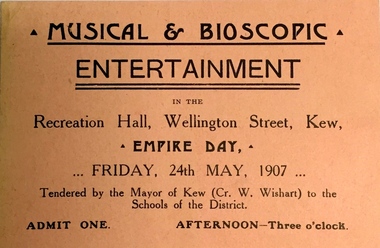
Card - Ticket, Musical and Bioscopic Entertainment, 1907
Considered a ‘worthy’ councillor, William [Bill] Wishart was ‘blunt’ in words and actions during his period of civic service. He was concerned with a picturesque Kew. This included street lighting, macadamised roads and improved access to Melbourne. Often accused of being German, he asserted his Australian birth and Scottish heritage. He was a strong advocate for women’s rights, believed in compulsory voting, favoured prison reform, opposed religious instruction in State schools, betting including horse racing, Home Rule, alcohol and sought to establish a tourist bureau. Cr. Wishart was ‘unanimously’ supported to nominate for the vacated seat of Richmond in Victoria’s Legislative Council. He narrowly lost the vote. After a sudden death, he was buried with Presbyterian rites in the Boroondara General Cemetery.Arthur Henry Dear was an employee of the City of Kew, acting as Hall Keeper of the Kew Recreation Hall in Wellington Street, and later the new Kew City Hall in Cotham Road. The Arthur Dear Collection contains memorabilia - tickets, programmes, invitations - as well as his identification badge.Admission ticket to a musical and bioscopic entertainment in the Recreation Hall, Wellington Street, Kew, on Empire Day, Friday 24 May 1907. The ticket was tendered to schools of the district, presumably students and teachers, by the Mayor of Kew, Cr. W. Wishart.arthur dear collection, empire day - kew (vic.), kew recreation hall -- wellington street -- kew (vic.), cr william wishart, mayors of kew -
 Kew Historical Society Inc
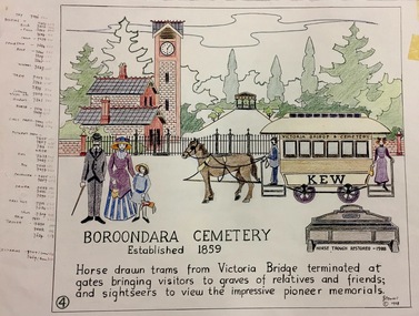
Work on paper, Joy Stewart, 4. Boroondara Cemetery, established 1859, 1988
Kew Tapestry The eight panels depict the history of Kew. This was a 1988 Australian Bi-Centennial Project carried out under the auspices of City of Kew Council and the Kew Historical Society Incorporated. Nearly 600 citizens including many children participated in the production by adding a few or more stitches. A book records their names and the panels upon which they worked. Artist: Joy Stewart Co-ordinator: Dorothy BenyeiSydney Joy (Joy) Stewart was born in Melbourne 1925. She studied at Swinburne Technical College Art School from 1941-1945, then the National Gallery Art School 1946-1948. Her career included employment positions as a display artist, designer/painter, gallery assistant, and art teacher. Joy relocated to Cairns in 1981. Solo exhibitions in Melbourne and Cairns, including 'Done By Me' at Cairns Regional Gallery in 1999. Group exhibitions at Cairns Regional Gallery, 'The Fish John West Regrets, 1993' and 'Facets of Life' 1994. Joy Stewart died in Cairns in 2018.4. Boroondara Cemetery, established 1859. A Handcoloured cartoon created by the artist Joy Stewart as a template for the fourth of a series of embroidered panels depicting the history of Kew. Wool colour codes at left. Inscription: "BOROONDARA CEMETERY, Established 1859. Horse drawn trams from Victoria Bridge terminated at gates bringing visitors to graves of relatives and friends; and sightseers to view the impressive pioneer memorials". Signed by the artist "(c) JStewart, 1988". bicentennial project (kew), boroondara general (kew) cemetery -
 Kew Historical Society Inc
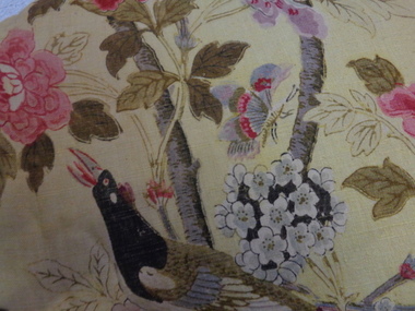
Decorative object - Paradise Bird Design Linen Curtains, GP&J Baker, 1920s
William Turner, a Scottish born free-lance designer, who was contracted to GP&J Baker, painted the image on which the design was based in 1918. Turner had trained as a furniture designer before leaving for London in the 1890s, where he rose to prominence as an Arts & Crafts designer. The bird that gives this design its name is adapted from Robert Havell’s ‘A Collection of Birds of Paradise’, published in 1835, and was a favourite of Victorian chintz designers.“Paradise Bird” has been in continuous production since its creation. The hand-block print, of which these curtains are an early example, was supplemented by a version engraved on copper rollers in 1962, and was updated onto screens in 1982. The curtains have significance to the collection because of their intrinsic value and for the link to one of the historic mansions in the City of Boroondara. The curtains by G.P & J Baker of London use one of the exemplary designs in this manufacturer’s output. The first use of the design was in 1918, following the Great War, and the design is said to reflect the hope for peace which was a feature of the postwar years. The curtains are an early example of the Paradise Bird design, and were block printed. A pair of curtains originally situated in one of the front reception rooms of 'Tourmont' in Balwyn Road, Balwyn (now Fintona Girls’ School). The fabric in the curtains was manufactured by the English firm of GP&J Baker. The textile design is variably named as ‘Paradise Bird’ or more recently, ‘Hydrangea Bird’. Turner’s bird perches in a blossoming branch directly above a woodpecker, which is an attribute of Mars, god of war. Thus the design reads as a symbolic statement where War is reversed and Paradise returns (a hopeful message at the end of WWI). “Paradise Bird” has been in continuous production since its creation. . curtains, fabric design, historic buildings -
 Kew Historical Society Inc
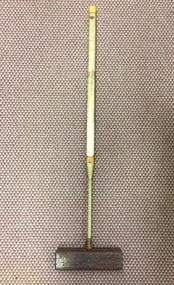
Equipment - Sports Equipment, Auburn Heights Recreation Club, Wooden Croquet Mallet, Twentieth Century
Sports Clubs in Kew in the final decades of the 19th century and in the early 20th century were often umbrella organisations with facilities for a number of sports. Typically in Kew, this included teams in lawn bowls, tennis and croquet. The Kew Bowling Club was formed in 1880 while the privately owned Auburn Heights Recreation Club was opened in 1904. The croquet courts at the Kew Recreation Club were opened in 1906, two years after the Club's formation. By 1998, the two Clubs decided to amalgamate at the Auburn Heights site in Barkers Road, forming the Kew Heights Sports Club. The combined club was itself taken over by the Melbourne Cricket Club in 2012 becoming MCC Kew Sports Club. In 2017 MCC Kew closed and its landholding was subsequently sold to Carey Baptist Grammar School. Both the Kew and Auburn Heights Clubs assembled important collections. These historically significant and large collections were donated to the Society in 2020. The collections include manuscripts, pictures, trophies, plans, honour boards etc. References Barnard FGA 1910, 'Sports and Pastimes' in Jubilee History of Kew Victoria: Its origin & progress 1803-1910. Chapman J & C 1999, The history of the Auburn Heights Recreation Club, 1904 to 1908. Reeve S 2012, City of Boroondara: Thematic Environmental History, p.216.The combined collections of the four sporting clubs making up the collection number hundreds of items that are historically significant locally. They are also significant to the sporting history of the greater Melbourne area and to the sports of lawn bowls and tennis in Australia in the 19th and 20th centuries. The collection illuminates two of the Victorian historic themes - 'Building community life' through forming community organisations and 'Shaping cultural and creative life' by participating in sport and recreation.Croquet mallet, Shaft made of a number of separate rectangular sections of pale wood, mostly wrapped with cotton cord and strips of leather. The rectangular head is made of a darker heavier wood and it is banded with a strip of lighter wood.croquet -- mallets, croquet -- equipment, auburn heights croquet club, auburn heights recreation club -
 Kew Historical Society Inc
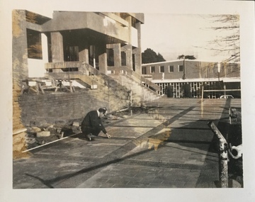
Photograph - Construction of the Kew Civic Centre, 1972
The Kew Civic Centre, as opposed to the adjacent Kew Civic Hall (see also Kew City Hall), was built to house a new Council Chamber and Council Offices in 1972. The Kew Library was to be located on the ground floor and accessed from the current carpark. This building replaced the former Town Hall in Walpole Street, Kew which had served as a town hall from 1865-1972. After the sale of the old Town Hall, the new Civic Centre was built to a design of the architects A K Lines, MacFarlane & Marshall. A fit-out of the building was still occurring when councillors and council officers moved into the building. In 1987, the Kew Library (and the Kew Historical Society) moved across the road to the reconfigured Civic Hall. The Civic Centre, pictured here, was ultimately sold to Trinity Grammar School following the amalgamation of Kew into the City of Boroondara.These four black and white photographs were taken by a photographer in the City Engineer's Department during the final construction phase. Each is dated and inscribed with a description.Laying of concrete tiles in the forecourt of the new Kew Civic Centre in 1972. The Civic Hall (now the Kew Library) is in the background. Annotated verso: "Civic Centre - Forecourt / 17.7.72"kew civic centre, kew civic offices, city of kew -- council chamber -
 Kew Historical Society Inc
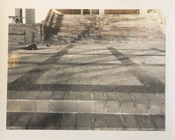
Photograph - Construction of the Kew Civic Centre, 1972
The Kew Civic Centre, as opposed to the adjacent Kew Civic Hall (see also Kew City Hall), was built to house a new Council Chamber and Council Offices in 1972. The Kew Library was to be located on the ground floor and accessed from the current carpark. This building replaced the former Town Hall in Walpole Street, Kew which had served as a town hall from 1865-1972. After the sale of the old Town Hall, the new Civic Centre was built to a design of the architects A K Lines, MacFarlane & Marshall. A fit-out of the building was still occurring when councillors and council officers moved into the building. In 1987, the Kew Library (and the Kew Historical Society) moved across the road to the reconfigured Civic Hall. The Civic Centre, pictured here, was ultimately sold to Trinity Grammar School following the amalgamation of Kew into the City of Boroondara.These four black and white photographs were taken by a photographer in the City Engineer's Department during the final construction phase. Each is dated and inscribed with a description.Forecourt of the new Kew Civic Centre in 1972.Annotated verso: "Civic Centre - Forecourt / 16.7.72"kew civic centre, kew civic offices, city of kew -- council chamber -
 Kew Historical Society Inc
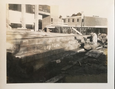
Photograph - Construction of the Kew Civic Centre, 1972
The Kew Civic Centre, as opposed to the adjacent Kew Civic Hall (see also Kew City Hall), was built to house a new Council Chamber and Council Offices in 1972. The Kew Library was to be located on the ground floor and accessed from the current carpark. This building replaced the former Town Hall in Walpole Street, Kew which had served as a town hall from 1865-1972. After the sale of the old Town Hall, the new Civic Centre was built to a design of the architects A K Lines, MacFarlane & Marshall. A fit-out of the building was still occurring when councillors and council officers moved into the building. In 1987, the Kew Library (and the Kew Historical Society) moved across the road to the reconfigured Civic Hall. The Civic Centre, pictured here, was ultimately sold to Trinity Grammar School following the amalgamation of Kew into the City of Boroondara.These four black and white photographs were taken by a photographer in the City Engineer's Department during the final construction phase. Each is dated and inscribed with a description.Tiling the steps leading from the forecourt to the new Kew Civic Centre in 1972.Annotated verso: "Civic Centre - Forecourt / 16.7.72"kew civic centre, kew civic offices, city of kew -- council chamber -
 Kew Historical Society Inc
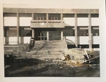
Photograph - Construction of the Kew Civic Centre, 1972
The Kew Civic Centre, as opposed to the adjacent Kew Civic Hall (see also Kew City Hall), was built to house a new Council Chamber and Council Offices in 1972. The Kew Library was to be located on the ground floor and accessed from the current carpark. This building replaced the former Town Hall in Walpole Street, Kew which had served as a town hall from 1865-1972. After the sale of the old Town Hall, the new Civic Centre was built to a design of the architects A K Lines, MacFarlane & Marshall. A fit-out of the building was still occurring when councillors and council officers moved into the building. In 1987, the Kew Library (and the Kew Historical Society) moved across the road to the reconfigured Civic Hall. The Civic Centre, pictured here, was ultimately sold to Trinity Grammar School following the amalgamation of Kew into the City of Boroondara.These four black and white photographs were taken by a photographer in the City Engineer's Department during the final construction phase. Each is dated and inscribed with a description.Creating the forecourt to the new Kew Civic Centre in 1972.Annotated verso: "Civic Centre - Forecourt / 16.7.72"kew civic centre, kew civic offices, city of kew -- council chamber -
 Surrey Hills Historical Society Collection
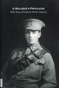
Book, A Soldier's Privilege - WW1 Diary of Frederick William Mawson
This is a transcription by Sandra Dexter of the original WW1 diary which was donated to ANZAC House by John Howden, F.W. Mawson's nephew. Sandra augmented the words in the diary with additional material including photos to give context to the people, places and events referred to in Frederick Mawson's words. Published with Surrey Hills Historical Society funds with permission of Anzac House librarian, Fred Pratt. Transcribed as a result of the loan of the original for the exhibition mounted as part of the 'Gallipoli and Beyond 2015' raft of events coordinated by City of Boroondara and the historical societies of Boroondara. Details re Fred Mawson (source AIF Project): Regimental number: 3073; Place of birth: Carlton, Victoria; School: Surrey Hills State School, Victoria; Religion: Presbyterian; Occupation: Carpenter; Address: Bona Vista Avenue, Surrey Hills; Marital status: Single; Age at embarkation: 22; Next of kin: Father, Frederick Mawson, Bona Vista Avenue, Surrey Hills; Enlistment date: 12 July 1915; Rank on enlistment: Sapper; Unit name: 5th Field Company Engineers; AWM Embarkation Roll number: 14/24/1; Embarkation details: Unit embarked from Melbourne, Victoria, on board HMAT A40 Ceramic on 24 November 1915; Rank from Nominal Roll: Lance Corporal; Fate Killed in Action 9 November 1917; Miscellaneous details (Nominal Roll): *second given name is William; Place of death or wounding: Ypres, Belgium; Age at death: 24; Place of burial: Ramparts Cemetery (Row J, Grave No. 24), Ypres, Belgium; Panel number, Roll of Honour, Australian War Memorial: 24. Also listed on the honour roll of The Shrine in the Surrey Gardens. A transcription (with footnotes and illustrations, including photographs) of a diary written in 1916 in F.W. Mawson during part of his period of service during WW1.(mrs) f w mawson, holmsdale, house names, bona vista avenue, surrey hills, world war 1, 1914 - 1918, diaries and journals, (mr) frederick william mawson, (mr) fred mawson,, (mr) frederick mawson (snr), surrey gardens memorial, sandra dexter -
 Surrey Hills Historical Society Collection
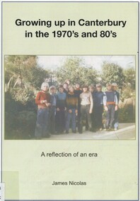
Book, Growing up in Canterbury in the 1970s and 1980s: a reflection of an era, 2015
... histories of Canterbury Primary School and Camberwell High School ...Purchased by SHHS from speaker - James Nicolas [16/6/2015] Author's account of living and growing up in Canterbury in the 1970s and 1980s. Includes brief histories of Canterbury Primary School and Camberwell High School.Author's account of living and growing up in Canterbury in the 1970s and 1980s. Includes brief histories of Canterbury Primary School and Camberwell High School.boroondara (vic) - history, canterbury (vic) - history - 20th century, (mr) james nicolas, canterbury primary school, camberwell high school -
 Surrey Hills Historical Society Collection
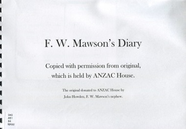
Book, F.W. Mawson's Diary facsimile
This is a photocopy of the original diary which was donated to ANZAC house by John Howden, F.W. Mawson's nephew. Copied using Surrey Hills Historical Society funds with permission of Anzac House librarian, Fred Pratt. Copied and later transcribed as a result of the loan of the original for the exhibition mounted as part of the 'Gallipoli and Beyond 2015' raft of events coordinated by City of Boroondara and the historical societies of Boroondara. Details re Fred Mawson (source AIF Project): Regimental number: 3073; Place of birth: Carlton, Victoria; School: Surrey Hills State School, Victoria; Religion: Presbyterian; Occupation: Carpenter; Address: Bona Vista Avenue, Surrey Hills; Marital status: Single; Age at embarkation: 22; Next of kin: Father, Frederick Mawson, Bona Vista Avenue, Surrey Hills; Enlistment date: 12 July 1915; Rank on enlistment: Sapper; Unit name: 5th Field Company Engineers; AWM Embarkation Roll number: 14/24/1; Embarkation details: Unit embarked from Melbourne, Victoria, on board HMAT A40 Ceramic on 24 November 1915; Rank from Nominal Roll: Lance Corporal; Fate Killed in Action 9 November 1917; Miscellaneous details (Nominal Roll): *second given name is William; Place of death or wounding: Ypres, Belgium; Age at death: 24; Place of burial: Ramparts Cemetery (Row J, Grave No. 24), Ypres, Belgium; Panel number, Roll of Honour, Australian War Memorial: 24. Also listed on the honour roll of The Shrine in the Surrey Gardens. A photocopy of a diary written in 1916 in F.W. Mawson during part of his period of service during WW1.(mrs) f w mawson, holmsdale, house names, bona vista avenue, surrey hills, world war 1, 1914 - 1918, diaries and journals, (mr) frederick william mawson, (mr) fred mawson,, (mr) frederick mawson (snr), surrey gardens memorial -
 Surrey Hills Historical Society Collection
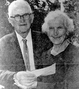
Photograph, Mr and Mrs Albert George Harbert
Albert, the son of William Devereux Harbert and Anna Maria Gooch) was born in 1890. He died 15 June 1971 in Malvern. Phoebe Rebecca Georgina Colton (b 1889, Williamstown; d 31 August 1968), the daughter of Henry Culter Colton and Elizabeth Georgina Lucas. Albert and Phoebe were married in 1912 and moved into the house Albert had built at 237 Union Road. He bought the 60 foot frontage block for £60 in 1912 and built the home for £240. Albert built a number of homes in the locality and the shelter sheds at Chatham School. Phoebe had worked as a seamstress prior to marriage, earning 2/6d a week. They had 2 daughters Unice and Norma. Unice remained single. Norma married Henry Jamieson. They both lived to a good age and continued to live locally until frailty in old age caused them to move to nursing homes. Albert and Phoebe are buried in Boroondara Cemetery Spec E, Grave 66. A black and white screened photograph of a man and a woman. The man is holding a piece of paper in his right hand.mr albert george harbert, mrs phoebe harbert, builders, union road, surrey hills, chatham school, miss phoebe colton -
 Surrey Hills Historical Society Collection
Photograph, Muriel Pornitz (deceased), Quarry on site of Grovedale Road - James Street Park
The photo is of a painting of the dam formed on land between Grovedale Road and James Street, Surrey Hills. It was painted in 1927 by Miss Muriel Pornitz, an art teacher, who lived in Grovedale Road. The land had been part of Mr James Maling Snr’s property and in the 1880s clay was removed to build houses, including his own located on the corner of Weybridge and James Streets. Maling grazed cattle on this area and used it as a dam. The land was subsequently made into parkland, the quarry / dam having been filled in after several drownings had occurred in the 1920s/1930s. See also SHP94, another copy of the same. Muriel Hedwig Lucy Pornitz lived at 22 Grovedale Road, Surrey Hills. She was born c1894 in Balwyn; died in Kew on 1 December 1982. She was the daughter of Konrad Pornitz (1864-1903) and his wife Charlotte Richardson Gooderidge (1863-1942), known as Tottie, who married in 1890. Konrad Pornitz is listed in the 1892 directory as living in Edgevale Road, Kew and the business Pornitz and Ross at 291 & 293 Little Collins Street, importers and commission merchants. The 1896 directory gives the Kew address as 176 Edgevale Road, Kew, however the business Pornitz and Ross was dissolved on 1st day of October 1892, by mutual agreement. Legal notice advised that: Mr Pornitz will hereafter carry on the business on his own behalf at the same address, under the style "Pornitz and Ross". Muriel is buried in Box Hill Cemetery (B-086-0042) along with Ulrich Horst Holm Pornitz known as Horst or Bon (d 1957) and Edith Olga Pornitz (d 1951), her brother and sister. A further sibling (Konrad b 1891) died in infancy. He is buried with his mother in Boroondara (Kew) Cemetery - C/E A 0366. Konrad died at his home 'Yarran' in Lane Cove Road, North Sydney on 31 October 1903; reported in the Sydney Morning Herald. Buried Gore Hill Cemetery, St Leonards, North Sydney. The headstone reveals he was born in Chemnitz, Saxony in 1863. Muriel was also known as Muriel Pornett. She studied at the South Australian School of Arts & Crafts in 1911 under James Ashton and Fred Britton, and at the Australian School of Etching in Sydney. She was also an illustrator and cartoonist. The photo, and the painting from which it is derived, documents the landscape prior to close settlement and is material to early building and farming in the Surrey Hills area.A black and white photograph of a painting of a landscape of parkland. Two trees are on top of a rise and are reflected at the bottom in water. The signature of the artist is in the bottom right corner: "AUST MP 192" (and the rest is cut off).(miss) muriel pornitz, grovedale road, james street, surrey hills, artists, parks and reserves, (mr) john butler maling, snr, quarry, dam, (miss) muriel hedwig lucy pornitz, box hill cemetery, muriel pornett -
 Surrey Hills Historical Society Collection
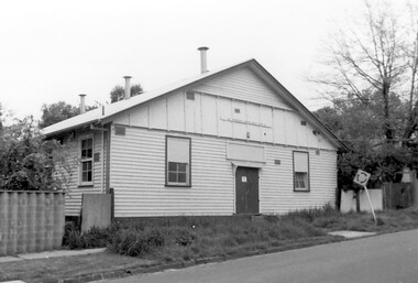
Photograph, Scout Hall at 7 Robinson Road, Surrey Hills in 1990
The Box Hill Reporter noted on 22 January 1926 that at the monthly meeting of the Surrey Hills Progress Association the Secretary reported that “the ground had been purchased for the Boy Scout Hall, that plans had been prepared, and accepted by the building committee. As soon as the timber was available the work would be proceeded with. The Boy Scout Hall movement has been taken up by the association to try to secure a permanent meeting place for the boys of the district. Up till now they have no fixed place, nor have they had a qualified scout master. Mr. Bert Chenu, one of the committee, has been appointed to that position, and is carrying out his duties energetically. Having raised enough money to purchase the land (situated in Robinson's road, Surrey-Hills near the Drill Hall) the association's committee is now about to erect the building by means of properly organised working bees.” The Association organised markets, card evenings and dances to raise necessary funds. The volunteer labour included the parents of boys who had become scouts, led by builder Robert Hayes of 186 Union Road and his son, who was also a builder. Early ownership is unclear as it is believed that it was not purchased by the scouting movement until 1955. The hall was used by other groups as well as the scouts. Benmont Kindergarten operated on the site from c1930. This is confirmed by oral testimony, Sands & McDougall entries and the Alan Hold property register (part of the SHNC Heritage Collection.) It was also used as a ballet school and for local dances. The hall was situated on a small block of land, just 410 sq m, and in late 2019 it was put up for sale by Scouts Victoria. Most recently home to 1st Boroondara Scout Group and previously 11th Camberwell Scouts, it was sold for something near $1.3M. During May 2020 the modest hall was demolished. Items of significance were removed before the sale by Scout Heritage. A black and white photograph of a building with a small sign identifying it as 11th Camberwell Central Scout Group.robinson road, surrey hills, scout halls, scouts, buildings, structures and establishments, (mr) robert hayes, union road, builders, surrey hills progress association, benmont kindergarten, dances, ballet schools -
 Surrey Hills Historical Society Collection
Photograph, Baby Health Centre in the Surrey Gardens, 1982, 1982
The Baby Health Centre opened in the Surrey Gardens in 1930 on the site previously occupied by the screen for outdoor pictures. Previously during the 1920s it had operated in the room underneath the rotunda in the Surrey Gardens. The room was also shared by other groups including the Surrey Hills Progress Association (SHPA). The SHPA raised 200 pounds to provide the materials for the building, which was built by voluntary labour under the leadership of Ralph Hayes, a local builder. The foundation stone was laid by Mrs A Latham, Mayoress of Camberwell on 31 March 1930. There is a bottle containing the names of the committee members sealed in the pillar behind the memorial stone. The centre was managed by a committee until 1975. Maternal health nurses associated with the centre included Sister D Thompson, Sister Newnham, Sister Kelsell, Sister Barker, Sister Sharp and Sister Bolton. Ref: Mrs D Lancashire - a long-serving member of the committee. The site of the Surrey Hills Maternal and Child Health Centre was moved to 18 Verdun Street, adjacent to the pre-school, in accord with Council policy to co-locate services and from a concern regarding solo staff working in relatively isolated locations. The building was included in the heritage overlay protecting the gardens and was refurbished by Council for community use. The cairn commemorates the work of Cr Albert Ernest Vine who was a Camberwell Councillor from 1926-1934 and 1937-1944; he was also Mayor on 1940-41. There is a photo of him in Mayoral robes in the City of Boroondara Library Service collection.Black and white photo of a timber building with a tiled roof and a brick veranda supported by brick and concrete pillars. In front of the baby health centre is a small cairn.surrey gardens, baby health centres, monuments and memorials, surrey hills progress association, cr albert ernest vine, sister d thompson, sister d. newnham, sister kelsell, sister barker, sister sharp and sister bolton, mrs a latham, ralph hayes, mrs d lancashire -
 Surrey Hills Historical Society Collection
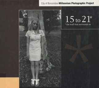
Book, 15 to 21: the stuff that surrounds us, 2001
Produced as part of the City of Boroondara's Milennium record.A collection of photographic images produced by young people aged 15 to 21 capturing aspects of life in the City of Boroondara of importance to them.photography, boroondara, millenium project, 2001, (ms) elise baro, (mr) daniel hender, (ms) elizabeth gonsalves, (ms) jess bartlett, (ms) sophie basseghi, (ms) georgia biggs, (ms) teagan boscia, (ms) robyn bowden, (ms) jennifer grindrod, (ms) jo fraser, (ms) jessie fowler, (ms) michaela brown, (ms) melanie cass, (mr) damian corney, (ms) denise damianos, (ms) laura edwards, sam forsythe, yi ya huang, branka injac, (mr) daniel ippoliti, fintona girls school, methodist ladies college, balwyn high school, xavier college, camberwell high school, camberwell girls grammar, hawthorn secondary college, carey grammar school -
 Surrey Hills Historical Society Collection
Photograph - 2 Beatrice Avenue, Surrey Hills Primary School, The Street Where You Live Project
Photos documenting this address as part of a photographic series undertaken by volunteer photographers during 2013 and 2014 for The Street Where You Live Project. This was organised through the Surrey Hills Neighbourhood Centre and covered the postcode 3127 in the cities of Boroondara and Whitehorse.These photos provide a snapshot of real estate in the suburbs of Mont Albert and Surrey Hills during a period of rapid change with many properties on large blocks demolished to create higher density residential development or renewal of single dwellings. At particular risk were properties not covered by heritage overlays, especially interwar housing and post 1950's housing. -
Canterbury History Group
Document - School Project: A history of 137 Mont Albert Road, Canterbury, Rush, Anne-Marie
A research paper for the Australian History option describing the history of 137 Mont Albert Road, Canterbury. The writer looks at the lives of various owners, particularly Henry Elgar and Richard Quittenton, and how the house has changed since it was built in 1890. includes 2 pages of plans of Elgar's Special Surveycanterbury, mont albert road, "haslemere", quittenton> richard, elgar> henry, elgar's special survey, boroondara estate -
Canterbury History Group
Document - School Project: Elgar's Special Survey, Tudehope, Jennifer, 1963
Well researched essay on the background of Elgar's Special Survey. Includes mapcanterbury, elgar> henry t., land surveys, boroondara, campbell> j & r, dacre> r, towns> r., sea> h., dyce> a., mccarthy> w.g., shenley> james, henty's paddock, norris> j.r., maling> j, canterbury road, survey road, boroondara roads board, camberwell historical society, mont albert road, brooks> r., land subdivisions -
Canterbury History Group
Ephemera - touchstones to WW1 in Balwyn, Camberwell, Canterbury and Surrey Hills, Susan Barnett, 1/04/2015 12:00:00 AM
Booklet compiled by Susan Barnett, President of the Surrey Hills Historical Society with the assistance of the Balwyn Historical Society, Camberwell Historical Society, Canterbury History Group and the Surrey Hills Historical Society, for a bus tour of significant places in Boroondara to commerate the centenary of the Gallipoli Landing.beckett park memorial, white> dorothy sevilla, cahill> francis matthew, cahill> martin, cahill> richard nicholas, cahill> kevin martin, lone pine dairy - balwyn, bignell> alfred charles, canterbury citizens carnival, canterbury gardens, soldiers - memorial hall - canterbury, canterbury memorial home units, canterbury primary school, camberwell city rsl sub-branch, golding> herbert, daly> gustav anthony disney, daly> william constant beck, daly> clarence wells didier, wattle park lone pine, clock tower memorial> wattle park, hethersett house - plc - burwood, surrey gardens - memorial cross, surrey gardens - the shrine, steele> mrs charles h d, blogg> john kendrick, gawler> john stephens, mawson> frederick w, webster> clarence -
Canterbury History Group
Book, Reichl, Phyllis, Andrew Murray of Balwyn House Boroondara, 1985
The story of the life of Andrew Murray, publisher and editor, and the remains of his house which was demolished to make way for the Science Wing at Fintona School.non-fictionbalwyn, balwyn road, canterbury, fintona girls school, balwyn house, vinyards, the economist, newspapers, boroondara roads board, vineyards -
Canterbury History Group
Letter - Strathcona promises to stay within its site, Walker, James, 4/08/2003 12:00:00 AM
... Grammar School City of Boroondara Town Planning Schools Resident ...Letter from James Walker published in the Progress Leader 4 August 2003, regarding the expansion plans of Strathcona Baptist Girls Grammar Schoolcanterbury, prospect hill road, strathcona baptist girls grammar school, city of boroondara, town planning, schools, resident action -
 Victorian Railway History Library
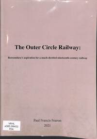
Book, Fearon, Paul Francis, The Outer Circle Railway: Boroondara's aspiration for a much-derided nineteenth-century railway, 2021
A thesis presented by Paul Francis Fearon to the School of Historical and Philosophical Studies about Boroondara's aspiration for a much-derided nineteenth century railway, as part of a Diploma in Arts (Advanced) in the field of History for the Faculty of Arts Melbourne University.ill, maps, p.71.non-fictionA thesis presented by Paul Francis Fearon to the School of Historical and Philosophical Studies about Boroondara's aspiration for a much-derided nineteenth century railway, as part of a Diploma in Arts (Advanced) in the field of History for the Faculty of Arts Melbourne University.railroad construction - victoria - history, outer circle railway - victoria - history