Showing 212 items
matching stone cottage
-
 Whitehorse Historical Society Inc.
Map, Schwerkolt property by Arthur Schwerkolt, 1993
Map of Schwerkolt property and rough plan of original stone house produced by Arthur Schwerkolt. Also copy of covering letterschwerkolt cottage -
Whitehorse Historical Society Inc.
Newspaper - Article, A Trip in time, 7/11/1990
Brief history of August Schwerkolt and his occupations as a stone quarrier, charcoal burner, farmer and wine producer. Also development of Cottage for historical value.schwerkolt, johann august, mullum mullum creek, city of nunawading, deep creek road, mitcham, faggetter, pat, schwerkolt cottage -
 Whitehorse Historical Society Inc.
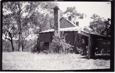
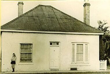
Photograph, Schwerkolt Cottage, 1962
Photo sent to Mary Jack, Pittsburgh USA by Charles Schwerkolt. Accompanying text sent by Charles - 'This is the end facing Deep Creek Road. You will notice the wood boards are all curved. The floor is all eaten away with white ants and is all levels and the weatherboards have fallen at the ends. The roof is very bad also the gable of the stone looks not so good. The wooden kitchen is about 6 inches away from the stone house all the way around. You will notice the roof of the stone house is all colours with rust and paint. You will notice there are no spouts to take the water away. I took another photo but the light got into the lens of my camera so they would not print a photo from it.Black and white photo of Schwerkolt Cottage. The condition of the Kitchen roof is visible. The floor was ant eaten and a 6"' gap separated the Kitchen from the Cottage. Thin Black Border.schwerkolt cottage, schwerkolt, charles clarence victor, whalen, rosalie, jackschowsky, mary elizabeth -
 Whitehorse Historical Society Inc.
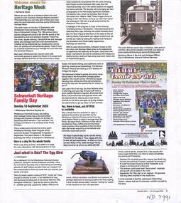
Article, Heritage Week 2023, Aug 2023
Heritage Day was Sunday 10 SeptHeritage Week 2023 in Whitehorse highlights transport and describes activities at Schwerkolt Cottage for Heritage Day on Sunday 10 Sept .non-fictionHeritage Day was Sunday 10 Septcity of whitehorse, schwerkolt cottage, heritage week 2023 -
 Whitehorse Historical Society Inc.
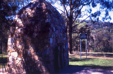
Photograph, Smoke House at Schwerkolt Cottage and Museum Complex
This smokehouse, erected in 1975, was built using stone from the Mullen Mullum Creek by stone mason Ray Williams, based on a photograph of a smokehouse in America. When a photograph of the original Schwerkolt smokehouse was found, it was seen to have a striking resemblance to the one erected in 1975Coloured photograph taken in 1970's of the Smoke House; constructed in 1975schwerkolt cottage and museum complex, smokehouses -
 Hume City Civic Collection
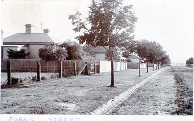
Photograph - Evans Street, Sunbury, c1880 - 1900s
The photograph shows a picture of Evans Street Sunbury taken from the T intersection at Macedon Street and looking south. When the photograph was taken it was one of Sunbury's main residential areas. Since the 1980s the houses in the image have been demolished and replaced with commercial development.- Over the years Evans Street has undergone much change from being a residential strip to being the main commercial hub in Sunbury.– An enlarged photograph of a streetscape with a row of trees growing along the footpath and a number of weatherboard Victorian style double fronted cottages. Both the roadway and footpath are not surfaced and the gutter is lined with stone pavers.sunbury -
 Bendigo Historical Society Inc.
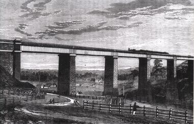
Photograph - TARADALE RAILWAY VIADUCT - ENGRAVING
Photocopy of photo: engraving shows Taradale Railway Viaduct completed. Steam train on viaduct. Stone piers supporting railway line on bridge. Underneath viaduct, post and rail fence, cottages in background.railways, bendigo to melbourne, taradale viaduct -
 Bayside Gallery - Bayside City Council Art & Heritage Collection
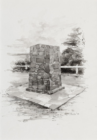
Work on paper - ink and watercolour, Annette Meikle, Moysey Memorial, 1977
In 1977, artist Annette Meikle undertook a commission to illustrate a book recording stories of places and people in the Bayside area. It was published in 1978 as Sandringham Sketchbook, with text by Elizabeth Waters. The sketches were intended to record remaining examples of Bayside’s early architecture and environment, as well as reflect newer architectural changes. Meikle went on to donate 22 of these sketches to Bayside City Council in 2003. Erected in 1964, this stone cairn on Beach Road in Beaumaris marks the site of the wattle and daub cottage of James and Susannah Moysey. James, Susannah and their cousin Nicholas arrived in Victoria in 1844 and leased land on the cliff-top. They built a cottage, cleared the land for sheep and cattle and established vegetable gardens. They later purchased the land and named it Beaumaris Park, derived from the name of the Welsh coastal resort where Edward I built Beau Marais castle.Annette Meikle, Moysey Memorial 1977, ink and watercolour, 35 x 23.5 cm. Bayside City Council Art and Heritage Collection. Donated by the artist, 2003annette meikle, sandringham sketchbook, elizabeth waters, port phillip bay, moysey memorial, coastline, stone cairn, james and susannah moysey, beaumaris -
 Sunbury Family History and Heritage Society Inc.
Photograph - Evans Street, Sunbury, c1900s
The photograph shows a picture of Evans Street Sunbury taken from the T intersection at Macedon Street and looking south. When the photograph was taken it was one of Sunbury's main residential areas. Since the 1980s the houses in the image have been demolished and replaced with commercial development. Over the years Evans Street has undergone much change from being a residential strip to being the main commercial hub in Sunbury.A sepia photograph with a white border across the bottom and in post card format of a streetscape with a row of trees growing along the footpath and a number of weatherboard Victorian style double fronted cottages. Both the roadway and footpath are not surfaced and the gutter is lined with stone pavers.EVANS STREETevans street -
 Maryborough Midlands Historical Society operating the Worsley Cottage Museum
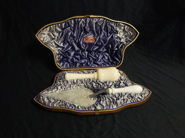
Trowel and mallet, Circa 1890
The trowel and mallet set was purchased by Mr Swanson, the builder of the Maryborough (Victoria) Railway Station prior to the planned ceremony for the laying of the foundation stone. Duncan Gillies. the Victorian Premier, was to lay the foundation stone, but his government was defeated in the week before the scheduled ceremony. The trowel and mallet set was never used. This set was held by the Maryborough Borough (later City) Council and lay unidentified for almost 120 years until a receipt from the jeweller was discovered. The set was donated to the Maryborough Midlands Historical Society in 2010.Ceremonial trowel and mallet set in brown leather covered presentation case with blue satin lining. Trowel has silver blade with cream handle possibly bone. Mallet cream, possibly bone. H. NEWMAN/Jeweller/MELBOURNE -
 Port Fairy Historical Society Museum and Archives
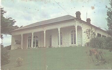
Photograph
The construction of Seaview commenced in 1860, after David Talbot, purchased the land from James Atkinson,It had been suggested that it was intended to be double storied but there is no evidence of how that would have been accomplished. Following Talbot’s insolvency, Michael O’Reilly leased the house in 1862 until 1876 when he left for Melbourne.William Powling (Solicitor) acquired the house for Eight hundred and twenty three pounds in 1890 and lived there the rest of his life. His son Ernest Powling continued living there before selling it to Matthew Cathcart in 1917.Coloured photograph of White painted stone house with bay window to right and large verandahcottage, building, home, house, seaview -
 Wodonga & District Historical Society Inc
Photograph - Stonleigh, Wodonga
Stonleigh is one of Wodonga’s earliest buildings and stands on land granted to Daniel Rhodes in 1854, in one of the first land sales conducted in Wodonga. The building commenced soon after with the stone walls being 18 inches (46cm) thick. It was a four-room granite rubble stone building with central door and a window on either side, with a separate kitchen, as was typical of the worker's cottage of the day. The original roof would have been shingles but it was replaced with corrugated iron. It passed through several owners including Paul Huon in 1858. Peter Tenner, a farmer and vigneron took over in 1866 when it was described as “built of stone and having a cellar and a detached kitchen plus outside toilet, and a shed or two.” In the late 1880’s it was owned by William Smith who had come to Wodonga as a missionary for the Presbyterian Church and who, together with John Whan, storekeeper, was instrumental in building the Presbyterian Church nearby. Between 1890 and 1910 further buildings were added, consisting of double brick walls, two bedrooms, kitchen, laundry with brick and copper, bathroom and side verandah. William Smith established Wodonga Cordage Works in the Stonleigh buildings. The front room of the house was the display room for the business which manufactured and sold fishing lines, various types of cordage and water bags, the latter being of hand-sewn canvas. After 1954 Stonleigh became a bottle depot and bottle museum under ownership of Ramon Porta. At one stage he had over 50,000 bottles on display. In 1991 it was purchased by Mark Fraser, a cabinet maker, who made extensive renovations at the rear of the premises and internally, but left the façade untouched. Over recent times, Stonleigh was the home of several business including a florist, a patchwork maker and a café. Stonleigh was sold in 2021 and is now a private residence.These images capture one of Wodonga's oldest buildings.A series of photos, both colour and black and white, showing the building "Stonleigh' at different periodsstonleigh wodonga, old buildings wodonga, wodonga businesses, wodonga pioneers -
 Flagstaff Hill Maritime Museum and Village
Photograph - Scene - Warrnambool, C. 1854-1871
This is an image of the Warrnambool Lighthouse Complex on Middle Island in 1854. The Store, Lighthouse Keeper's Quarters, Lighthouse and Flagstaff are in the background. The foreground shows a covered buggy drawn by two horses and a person in attendance, and another wheeled vehicle behind it with a figure nearby. There is a saddled horse to the right with two males in conversation nearby. The ground is soft, perhaps the riverbed or sandy shore. THE LIGHTHOUSE KEEPERS Lighthouse Keepers were responsible for keeping their Lighthouse’s lights shining at night. They kept a lookout for passing vessels and changes in weather. They were expected to clean, polish and maintain the equipment and buildings. They kept regular and detailed records of who was on watch, and the time the light was lit, trimmed and extinguished. They kept a journal about other events that occurred. They keep regular, accurate Meteorological Logs. It was expected that they were competent in Morse code signalling. They would be called to help in times of disasters and shipwrecks and to give official statements about these events. Many Lighthouse Keepers also volunteered as members of the lifeboat crew. The Lady Bay lighthouses were officially classified as small, so the Keepers had the official titles of Senior Assistant Lighthouse Keeper and Assistant Lighthouse Keeper. They were employed by the Public Service and paid rent to live in the Lighthouse Quarters. They were compulsorily retired at the age of 60, with most receiving a superannuation payment. Despite their time-consuming duties, there was time to follow hobbies and crafts such as growing vegetables, playing musical instruments, making models of buildings including lighthouses, and crafting furniture pieces. An example of a keeper’s skills is the carved fire screen made by /assistant Keeper Thomas Hope in the late 19th century and displayed in the Lighthouse Keeper’s cottage at Flagstaff Hill. Both Alexander and Farncombe had served under Senior Keeper Robert Deverell, who was the first and only Senior Lighthouse Keeper at the Middle Island Complex. John Alexander was the Assistant Keeper in the 1850s. Andrew Farncombe was the last Assistant Keeper at Middle Island, serving there with his family from 1864 to 1871. During 1871 and 1872 the Lighthouse Complex was moved to Flagstaff Hill on Merri Street. Farncombe and Deverell then became the first Keepers and occupants of the Lady Bay Lighthouse Complex at Flagstaff Hill. They continued their service together; overall, Deverell served from 1859 to 1885 and Farncombe from 1864 to 1974. WARRNAMBOOL'S LADY BAY LIGHTHOUSE COMPLEX - The original Lighthouse Complex was built on Middle Island in 1858-1859 then transferred stone-by-stone to Flagstaff Hill in 1871. The Complex comprised the Lighthouse, the Lighthouse Keepers’ Quarters and a Privy. The bluestone Keeper’s Quarters was a cottage divided into two compartments, one for the Senior Keeper and his family, the other for the Assistant Keeper and his family. The bluestone Store was divided into three; a store, a workshop, and an oil store (or office). The Privy comprised a small building also divided into two separate, back-to-back toilets, one for each Keeper and his family. In the 1970s the Flagstaff Hill Planning Board was set up under the chairmanship of John Lindsay. The Board was to make recommendations to the Warrnambool City Council regarding the use of the buildings and the rest of the Crown Land on the site. The Flagstaff Hill Maritime Village opened in 1975 and began renovating the Cottage in stages, during which time evidence of a 1920s fire was found in the eastern section of the cottage. Additions of a porch on the west and a washroom on the east were made in the 1980s. The western part of the building is now a Shipwreck Museum and the east has returned to a late 19th-century Lighthouse Keeper’s cottage and includes the screen made by Assistant Lighthouse Keeper Thomas Hope in the late 19th century. Hope served two periods of time at the Lighthouse. This photograph is significant as a visual record of the original Warrnambool Lighthouse Complex on Middle Island, the origin of what is now the Lady Bay Lighthouse Complex. The photograph is significant for its connection to the Complex, which is now listed on the Victorian Heritage Register, H1520, for being of historical, scientific (technological) and architectural significance to the State of Victoria. The Complex is significant as an example of early colonial development. The photograph is significant for its connection with the important navigational function of the Lighthouses, a function still being performed to this day. The photograph is also significant as it shows an example of buildings organised by the Public Works Department in Victoria in the mid-to-late 19th century. The structures tare still stand strong. Photograph of horses, a buggy and three gentlemen in the foreground and the background shows a lighthouse and accompanying buildings. Printed in black and white. (Another two horse-drawn vehicles are partially visible). The subject is the Lighthouse Complex on Middle Island, Warrnambool, dated between 1854 and 1871.An inscription is handwritten in black pen on the back of the mounting board."The lighthouse and accompanying buildings were / established on Middle Island in 1854, as this / picture shows. In 1871 they were moved to their / present site on Flagstaff Hill."flagstaff hill, flagstaff hill maritime museum, flagstaff hill maritime village, warrnambool, maritime museum, shipwreck coast, lighthouse keeper's cottage, lighthouse residence, lighthouse, chart room, quarters, privy, middle island, beach lighthouse, obelisk, lighthouse complex, lady bay complex, warrnambool port, warrnambool harbour, lady bay, keepers, lighthouse keeper, upper lighthouse, lower lighthouse, assistant keeper, ports and harbours, cottage, meteorological record, 1854, 1871 -
Bendigo Historical Society Inc.
Document - Samson's Cottage Significance Assessment, 1967
The first, two-roomed, stage of the present cottage appears to have been commenced before 1866, when the first rate notice appeared (Shire of Marong) and possibly as early as the mid-1850s, when the first owner, Thomas Samson, a shoemaker turned joiner, came to the Bendigo goldfields. Samson took up a miner's right in Spec(k) Gully in the mid-1850s. The Samson family had ten children and as the family grew they extended the cottage in stages. Samson worked as a miner until about 1871, then returned to boot making from a weatherboard shed on the property. He opened a shop on the corner of Booth and McKenzie Streets in partnership with John Shocker in 1889. He died in 1893. His wife Sarah remained in the cottage until 1906. Albert and Florence Doye purchased the site in 1908 and the family lived there until 1966. The property has remained in the hands of the family, mostly unoccupied. It was renovated by a tenant in the 1970s and passed from miner's right to freehold in 1974. It is currently owned by Arthur Doye, who lives nearby, and is unoccupied. During its early life it, probably during the Samson occupation, it was altered and extended many times into a complex arrangement of structures and outbuildings. Stone remained the dominant building material throughout, even for the poultry shedsThree page report on the significance of Sansom's Cottage, 21 Doye Street, Golden Square, Bendigo. Topics include what is significant; why is it significant; permit exemptions; assessment against criteria; extent of registration and contextual history. Final page on 'history of place' is missing from document.sansom cottage, golden square, heritage register, sandstone, miner, shoemaker, thomas sansom -
 Linton and District Historical Society Inc
Photograph, Early Pitfield, Showing Bridge, Store and Hotel
Identified by inscription on the back of the photograph as "Early Pitfield", and the buildings as "Matthew Hamilton Baird's . . . hotel & store". Information from Joan Hunt (see 'Pitfield/Kaleno' file) says the Emu Inn or Pitfield Hotel was at Pitfield/Wardy Yallock township on the road from Skipton to Geelong. Part of this area - foreground, to the left, was called "Buncle's Flat", named after John Buncle, a carpenter who lived in a cottage there with his family. An early timber inn on the Wardy Yallock Creek was owned first by Peter Hardie and then by Edward Langhorne/John McNamara in the 1840s and a mail run from Geelong was established to it in 1846. Matthew Hamilton Baird was the lessee or owner from 1852, and Benjamin Fernald from about 1860. In 1853, the nearby store, at that time owned by William Whitecross, caught fire. The fire spread to the hotel and both buildings were destroyed. The hotel was replaced by the brick or stone building seen in the photograph.Small black and white copy of original photograph which shows trees, fencing and farm buildings in foreground, and in the background a large stone or brick building plus smaller timber buildings (dwellings?) situated along a roadway. On the right of the photograph the road goes over a large bridge of timber construction.On back of photograph: "Early Pitfield showing Matthew Hamilton Baird's store (stone?) & hotel & store".pitfield bridge, pitfield hotel, pitfield township, buncle's flat, emu inn, buildings, hotels, matthew hamilton baird, benjamin fernald, edward langhorne, john mcnamara, william whitecross -
 Eltham District Historical Society Inc
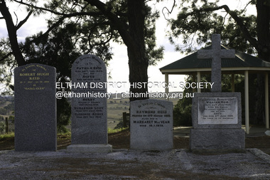
Photograph - Digital Photograph, Alan King, Reid family graves, Arthurs Creek Cemetery, 30 March 2008
... at Mearns in Renfrewshire, Scotland. Reid built a small cottage from... at Mearns in Renfrewshire, Scotland. Reid built a small cottage from ...The Arthurs Creek Cemetery was originally the private cemetery of pioneers Agnes and Patrick Reid. Published: Nillumbik Now and Then / Marguerite Marshall 2008; photographs Alan King with Marguerite Marshall.; p11 The Hazel Glen property, at Middle Hut Road, Arthurs Creek, which includes one of Victoria’s earliest pioneer buildings, was the forerunner to the Arthurs Creek and Doreen townships. At one time the Doreen Post Office and school were called Hazel Glen. The Hazel Glen State School No 945, before it was moved to its present site, stood on land to the south of Chapel Lane, which had been donated by Hazel Glen owner, William Reid. In May 1895 the post office was renamed Doreen to avoid confusion with the Reid’s address. The Arthurs Creek Cemetery was originally the private cemetery of Hazel Glen pioneers Agnes and Patrick Reid. The Reids with their eight children, arrived in Melbourne in April 1839. In 1844 Patrick Reid took over the licence to the Stewart Ponds run of 5120 acres (2072ha). Reid renamed it Hazel Glen, after Hazelden, the name of the Reid estate at Mearns in Renfrewshire, Scotland. Reid built a small cottage from local stone and hand-made bricks, with walls one yard (91 cm) thick, a flagstone floor and a shingle roof. Today two rooms and a store room survive as part of a larger house. Agnes died in 1847 aged 49, and was buried on a hill overlooking Hazel Glen, where it is said she had asked to be buried as it had been a favourite picnic spot.2 In 1858 Patrick died aged 74, and was buried near her. Their son William was to become Whittlesea Shire’s first president. From 1868 he was a Whittlesea Roads Board member, then a shire councillor until shortly before his death in 1923 aged 88. In 1865 the Reid’s burial area was no longer on their property, so it was declared a cemetery site. In 1867 it became the Linton Public Cemetery, being in the Linton Parish. However, to avoid confusion with Linton near Ballarat, the cemetery was renamed the Arthurs Creek Public Cemetery in 1926. Arthurs Creek was named after Henry Arthur, a pastoralist and public servant, who ran 1000 sheep lower down the Creek, from 1836 to 1841. It is believed he built his home at the end of today’s Challenger Street in Diamond Creek.This collection of almost 130 photos about places and people within the Shire of Nillumbik, an urban and rural municipality in Melbourne's north, contributes to an understanding of the history of the Shire. Published in 2008 immediately prior to the Black Saturday bushfires of February 7, 2009, it documents sites that were impacted, and in some cases destroyed by the fires. It includes photographs taken especially for the publication, creating a unique time capsule representing the Shire in the early 21st century. It remains the most recent comprehenesive publication devoted to the Shire's history connecting local residents to the past. agnes reid, arthurs creek cemetery, nillumbik now and then (marshall-king) collection, patrick reid, reid family -
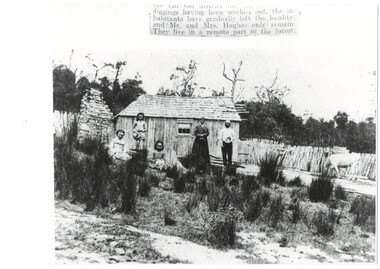 Buninyong & District Historical Society
Photograph - Photograph of Original Photograph, Hughes family of Lal Lal, 1870's, 1870s
historic, social, familyIn Lal Lal forest, Hughes family in front of primitive bark miner's hut with shingle roof, rough stone chimney on left, parents and youngest daughter standing, two older daughters seated, scrubby grass in foreground, rough picket fence and a cow. incomplete label: "...diggings having been worked out, the inhabitantshave gradually left the locality, and Mr. and Mrs. Hughes only remain. They live in a remote part of the forest." lal lal, hughes family, miner's cottage -
 Eltham District Historical Society Inc
Photograph - Digital Photograph, Marguerite Marshall, Former home of Professor William MacMahon Ball, York Street, Eltham, 24 May 2007
Situated at the eastern end of York Street, Eltham, 'Shinrone', the former home of Professor William (Mac) MacMahon Ball was one of the first in the Shire of Eltham to incorporate mud-brick. Professor MacMahon Ball, a political scientist, writer, broadcaster and diplomat and family moved to York Street, Eltham in 1945 into a timber cottage built around the 1890s and in poor repair. Mac asked Alistair Knox to renovate the home and he expanded the living area and added verandahs. In 1948 Montsalvat artist and sculptor Sonia Skipper supervised the building of most of the mud-brick studio. Neighbour Gordon Ford made the mud-bricks. Mac also asked John Harcourt, who had worked with him as a journalist in shortwave broadcasting, to build a pise (rammed earth) and stone addition to the largely timber house. Harcourt built two bedrooms - including an attic bedroom - a balcony with a shower and toilet, a nd a fireplace and chimney of local stone. Published: Nillumbik Now and Then / Marguerite Marshall 2008; photographs Alan King with Marguerite Marshall.; p141 At the eastern tip of York Street, Eltham, stands Shinrone, the former home of one of Australia’s intellectual leaders. Professor William Macmahon Ball, was one of the first to bring Asia as a foreign policy issue to the Australian public.1 He was a political scientist, writer, broadcaster and diplomat. The house was one of the first in Eltham Shire to incorporate mud-brick,2 because of the acute shortage of building materials after World War Two. Its novice builders later become leaders in Eltham’s built and garden design. Mac (as he was usually called), who was the son of a Church of England minister, was born in Casterton, Victoria in 1901 and died in 1986. In 1945 he helped establish the United Nations, as political consultant to the Australian Delegation at the San Francisco Conference.3 Then in 1946 Mac was appointed British Commonwealth Representative on the Allied Council for Japan, which is recorded in detail in his diary.4 In 1948 Mac led an Australian Government Goodwill Mission to South East Asia. However, Mac was perhaps most successful as an academic and public speaker.5 He was a commentator on the Australian Broadcasting Commission, from the early 1930s to the early 1960s. He was also Controller of the Short-Wave Broadcasting Unit during World War Two, which later became Radio Australia. From 1923 he taught at The University of Melbourne, then became foundation Professor of Political Science in 1949 and was Chair until his retirement in 1968.6 In 1942, as the government expected a Japanese invasion, Mac’s wife Katrine and their only child Jenny, moved from Kew to Eltham as temporary evacuees. However Mac and Katrine lived in Eltham for almost the rest of their lives. After staying with friends, they rented a house in Reynolds Road, where, as it was wartime, they needed to keep horses for transport and a cow and poultry for milk and eggs. In 1945 the family moved to the house at York Street, which was then a timber cottage, built around the 1890s and in poor repair. The underground well, cellar and part of the garden are all that remain of what stood on the original 18 acre (7.3ha) allotment. Thanks largely to Katrine’s hard work, the house was gradually renovated and extended. The long rambling house was partially built by several young neighbours, who were inspired by the cheap mud-brick and stone building style of Montsalvat, the Eltham artists’ colony. Mac asked Alistair Knox to renovate Shinrone, named after an Irish village near Katrine’s family home. Knox later popularised the mud-brick style of house construction, for which Eltham became known. He expanded the living area and added verandas. In 1948 Montsalvat artist and sculptor Sonia Skipper supervised the building of most of the mud-brick studio. Another neighbour, Gordon Ford, who was to have a major influence on the Australian garden style, made the mud-bricks. Mac also asked John Harcourt, who had worked with him as a journalist in short-wave broadcasting, to build a pisé (rammed earth) and stone addition to the largely timber house. Harcourt built two bedrooms – including an attic bedroom – a balcony with a shower and toilet, and a fireplace and chimney of local sandstone. With pioneering work naturally came mistakes, including one particularly dramatic incident when Harcourt was building walls with unsupported sections. Jenny Ellis, Mac’s daughter, remembers being awakened from sleep by a thundering shudder. The wall of her room had fallen down – fortunately away from her! In 1950 artist Peter Glass – another neighbour and later landscape designer – built Katrine a mud-brick pottery. As a result, the house features at one end Harcourt’s characteristic steep gable roof, while at the other the flatter construction characteristic of Knox. Mac referred to the home as the Eltham ‘experimental building site’.7 Surprisingly, the combination works, perhaps partly because it has the warm inviting feel of timber, mud-brick and stone.This collection of almost 130 photos about places and people within the Shire of Nillumbik, an urban and rural municipality in Melbourne's north, contributes to an understanding of the history of the Shire. Published in 2008 immediately prior to the Black Saturday bushfires of February 7, 2009, it documents sites that were impacted, and in some cases destroyed by the fires. It includes photographs taken especially for the publication, creating a unique time capsule representing the Shire in the early 21st century. It remains the most recent comprehenesive publication devoted to the Shire's history connecting local residents to the past. nillumbik now and then (marshall-king) collection, eltham, alistair knox, gordon ford, john harcourt, mudbrick construction, pise construction, professor macmahon ball, shinrone, sonia skipper, york street -
 Glenelg Shire Council Cultural Collection
Painting, Ruth Denny, Gardens Cottage Portland 1857, 1967
CEMA Art collectionThe painting depicts a blue stone building with green door. On either side of the door is a window and there is a chimney at either end of the roof. The side of the house closest to the viewer is overgrown with vegetation which extends up to and covers the chimney. To the right of the building is a green fence with a leaf-less tree behind. To the left of the building is a smaller green fence with several green trees behind. The work has a plain wooden frame with a mount and glass.Front: Gardens Cottage Portland 1857 Ruth Denny 1967 (black, handwritten) Back: Sticker: DEANS MU 8291 FOR FRAMING 346 LT. COLLINS ST., MELB. NO. 20438 Yellow sticker: 3033portland, female artist, female, women, botanic gardens, curator's cottage -
 Nepean Historical Society
Photograph - Derived From Stereograph at 1312.07, Clark's Cottage
The house was built in 1850 to resemble a Scottish crofter's cottage. It was at one time a postal depot, when a bag was fixed behind a slot in one of the front doors. It was also known as Clark Cottage. It has since been demolished.Sepia image of the first stone building in Sorrento, with description and signature of George Coppin.Sorrento The first building (signed) Geo. Coppinhouses -
 Flagstaff Hill Maritime Museum and Village
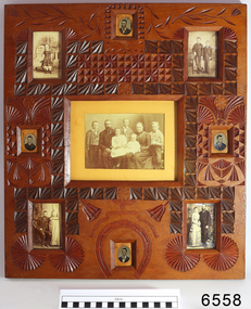
Photograph - Portraits, c. 1904
Ann Dale (nee Lees) was given this frame by her younger brother Thomas Chamberlain Lees, who was eighteen at that time. Thomas was the youngest son and seventh child of Lees and Sarah (nee Chamberlain) Lees. Ann loved her little brother’s artistic talents, which are demonstrated in this frame he designed and carefully carved for her. Thomas had cleverly finished the back with timber pieces around the images, and a section of a 1904 calendar. His “GOOD LUCK” is below the image of Ann, her husband Ellis Dale and their five children, c 1900. Sadly, Thomas died in 1911, aged 25. Ellis Dale’s father, William, was a quarryman who sailed from Yorkshire to Australia in 1852. He later bought land for Dale’s Quarries on the edge of Warrnambool in the area of Dale and Aberline roads. From the age of about eleven, Ellis and his brother worked in the quarry beside their father. In 1890 Ellis Dale married Ann Lees. Ann had lived nearby at Wangoom with her parents, Lees and Sarah Lees, who had had her photograph taken when she was a little girl, wearing her black dress. Ellis built a bluestone cottage for himself and Ann on his father’s land in Dales Road. He later added weatherboard rooms, and they named their finished home “Latrigg”. Early in their marriage Ellis recycled some empty dynamite boxes from their quarry to build a cupboard with drawers for Ann’s flat irons and other ironing equipment. The cupboard was used by future generations until recently, when Ann’s granddaughter, Betty Stone, donated it as part of the Chamberlain Dale Lees Collection. It is now in the kitchen of the Port Medical Office. Chamberlain Dale Lees family – local Colonial Pioneers Centre: Ellis Dale and Ann (nee Lees) and their five children - c 1900. Sons lvor William, Robert Ellis, Alfred John, and daughters - Elsie Mary Dale, and Daisy Elvena Dale. Top Left: Ann Lees - c 1868, (the little girl in the black dress) Top Right: William Dale Jnr. and Ellis Dale - c 1871 Lower Left: Ellis Dale and Ann (nee Lees), married 22 Jan. 1890 Lower Right: William Dale Jnr. and Agnes (nee Gillies), married 1883 Oval Photographs: unidentified but presumed to be family members [NB Spelling of Ann Dale – The spelling of Ann’s name has been confirmed by Betty Stone as being “Ann” (Not Anne), by phone conversation with Flagstaff Hill Maritime Village, K P 14th April 2014] (Note: For additional information please refer to Betty Stone’s book “Pioneers and Places - A History of three Warrnambool Pioneering Families” ie. Chamberlain, Dale and Lees Families)This item is associated with the families of Chamberlain, Dale and Lees. These families are listed in the "Pioneers' Register" for Warrnambool Township and Shire, 1835-1900, published by A.I.G.S. Warrnambool Branch. The handmade frame is a unique example of clever craftsmanship and carving skills used by early pioneers with limited access to materials.Family photographs, nine, set into carved, solid wood frame, stained and lacquered. Carving includes leaves, flowers, a horseshoe and a ribbon with the words "GOOD LUCK" Photographs are of the Lees family of Wangoom, from the 'Chamberlain Dale Lees Collection’ Made by Thomas Lees for his sister, Ann. The little girl with black boots on is Betty Stone's grandmother. The back of the frame has a London calendar dated 1904.Words in carved ribbon "GOOD LUCK" Calendar for the year 1904flagstaff hill, warrnambool, shipwrecked coast, flagstaff hill maritime museum, maritime museum, shipwreck coast, flagstaff hill maritime village, great ocean road, chamberlain, dale, lees, stone, betty stone, warrnambool pioneers, thomas lees, wangoom, ann dale, ellis dale, flagstaff hill, warrnambool, shipwrecked coast, flagstaff hill maritime museum, maritime museum, shipwreck coast, flagstaff hill maritime village, great ocean road, chamberlain, dale, lees, stone, betty stone, warrnambool pioneers, thomas lees, wangoom, ann dale, ellis dale, thomas chamberlain lees, handmade photograph frame, carved photograph frame, dynamite -
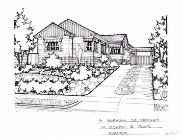 Whitehorse Historical Society Inc.
Artwork, other - Ink Line Drawing, Margaret Picken, 4 Norman St., Mitcham, 2002
A property illustration by Margaret Picken Commissioned by a real estate agency for the purpose of advertising 4 Norman St., Mitcham This property is listed as having sold for $350,000 in 2002 Made by using Rotring ‘Rapidigraph’ drafting pens with Rotring ink on Rapidigraph polyester drafting film, double matte. Trained as a cartographic draftsman within the mining industry, Margaret Picken is an artist who worked producing property illustrations for real estate agencies in eastern suburbs of Victoria from 1983-2005. Retiring from the industry as technological changes favored coloured photography over illustrations, and commissioning companies over sole contractors.This artwork is of Historical Significance as a record of local domestic architecture.A black ink line drawing on drafters film by Margaret Picken, of 4 Norman St., Mitcham depicting a black and white line drawing of a weatherboard house with striped retractable window awnings. On the right is a driveway leading to a connected carport in the background. On the right in front of the house is a front garden with shrubs, trees , and stone edgings.14 Manorwood Plc. Mitcham M.Picken © 2002 Realatorwhitehorse historical society, schwerkolt cottage, housing, architecture, margaret picken, house, garden, real estate, mitcham -
 Old Gippstown
Building - Slab Kitchen
A slab construction cottage built in Ripplebrook in 1880 as a home for a single female landowner by the name of Ada Donaldson, and later relocated to Labertouche. It was donated to Old Gippstown by the Mason-Brook Pastoral Co. of Labertouche. A small building of horizontal timber slabs. It has a verandah over the front entrance and the front porch, a main living area with a cast iron stove in the fireplace and a separate room (probably a bedroom). There is a stone chimney on the back wall and the roof is shingled. Originally a cottage in its own right, the slab kitchen is now a part of the Bushy Park display.Medium local historic significance.A small building of horizontal timber slabs. It has a verandah over the front entrance and the front porch. There is a stone chimney on the back wall and the roof is shingled. This building was built in 1880sout kitchen, old gippstown, west gippsland, gippsland, gippsland heritage park, goldfields, coal mine, victorian era, moe, historical village, timber slab cottage, ripplebrook, labertouche, mason-brook pastoral co., baw baw shire, latrobe valley, old gippsland heritage park, gunaikurnai, latrobe city council -
 Flagstaff Hill Maritime Museum and Village
Photograph - Historical, building, Late 19th to early 20th century
The black and white photograph depicts the Lady Bay Lighthouse Complex at Flagstaff Hill, Warrnambool. It was opened on this site in 1871. From left to right, the Chartroom (previously named the Store), Upper Lighthouse, Flagstaff, Lighthouse Keeper's Quarters. The bluestone buildings are facing North on Merri Street. The Harbour Pilot's Lodgings were on the east of the Complex. There are two unknown male figures standing in front of the light-coloured picket fence that encompasses the Complex. The photograph is mounted on card. WARRNAMBOOL'S LADY BAY LIGHTHOUSES In the 1800s ships sailing from England to Australia began to use Bass Strait as a faster route to Melbourne. Small navigation errors led to many tragic shipwrecks. From 1848 lighthouses were operating along Victoria’s southern coast as a guide for sailors. Coastal towns such as Warrnambool grew and the exchange of trade and passengers was of great benefit. However, the uncertain weather changes, relatively shallow waters and treacherous, hidden rocky reefs were not really suitable for a Harbour and in the 1840s and 1850s, there were many shipwrecks in the area, with some even stranded in its Lady Bay harbour. A jetty was built in 1850 and a flagstaff to guide seafarers was placed up high on what became known now as Flagstaff Hill. In November 1857 the Victorian Government recommended that Warrnambool Harbour had beacons and two lighthouses to guide vessels into and out of the Harbour safely. The white light of the Middle Island lighthouse was to be used for the first time on September 1, 1859. The red light of the Beach Lighthouse, a wooden obelisk structure, was first operated on March 25, 1860, but in 1868 this light was ‘discontinued’ due to it being too low. Melbourne’s Department of Public Works decided to relocate the Middle Island Lighthouse Complex - Lighthouse, Keeper’s Quarters, Privy, Store Room and even water tanks - to Flagstaff Hill. The lower obelisk was shortened, and a protruding gallery, railing, and external ladder were added, and the light from the Beach Lighthouse. A green guiding light was erected on the end of the jetty. The transfer of the Complex began in March 1871. Each shaped stone of the lighthouse was carefully numbered, removed then reassembled on Flagstaff Hill. In 1872 the well was sunk behind the Lighthouse Keeper’s Cottage. The Keepers and families had left Middle Island in April and moved to Flagstaff Hill in October 1871. Vessels entering Lady Bay align the Upper and Lower Lighthouse towers during the day and the lights at night. The Upper Lighthouse is a round tower, and the Lower Light is square. The Lighthouses were categorised as harbour lights rather than coastal lights, so they remain under the control of the Victorian Government’s Ports and Harbours section. The lights were originally powered by oil, then acetylene gas, later by electricity, and then converted to solar power in 1988. In 1993 the solar panel was replaced by a battery charger. A decision was made in 1936 to replace the lighthouses’ lights with unattended lights that no longer required Keepers and Assistants. At least 29 Keepers had attended to the lighthouse from its opening in 1859 to when the last official Lightkeepers left In April 1916. The Warrnambool Harbour Board rented out the Quarters from 1916 to 1936. The Board closed down but the rentals continued with other unknown landlords. In the 1970s the Flagstaff Hill Planning Board was set up under the chairmanship of John Lindsay. The Board was to make recommendations to the Warrnambool City Council regarding using the buildings and the rest of the Crown Land on the site. The Flagstaff Hill Maritime Village opened in 1975 and began renovating the Cottage in stages, during which time evidence of a 1920s fire was found in the eastern section of the cottage. Additions of a porch on the west and a washroom on the east were made in the 1980s. The western part of the building is now a Shipwreck Museum and the east has returned to a late 19th-century Lighthouse Keeper’s cottage and includes the screen made by Assistant Lighthouse Keeper Thomas Hope in the late 19th century. He served as Assistant Keeper in Warrnambool for two periods.The Warrnambool Lighthouse Complex is now listed on the Victorian Heritage Register, H1520, for being of historical, scientific (technological) and architectural significance to the State of Victoria. The Complex is significant as an example of early colonial development. The buildings are significant for their connection with the important navigational function of the Lighthouses, a function still being performed to this day. The buildings are also significant as an example of structures designed and works carried out by the Public Works Department in Victoria in the mid-to-late 19th century. The structures still stand strong. Photograph; Warrnambool Lighthouse Keeper's cottage, lighthouse, flagstaff and chartroom at Flagstaff Hill, and a light-coloured picket fence with gate. Two male figures are in front of the fence. Black and white print glued to a yellow card. The inscription is indecipherable. The right side of the cottage has a built-in, enclosed addition.Ink stamped in lower right hand corner, too faded to be legible.flagstaff hill, flagstaff hill maritime museum, flagstaff hill maritime village, warrnambool, maritime museum, shipwreck coast, lighthouse keeper's cottage, lighthouse residence, lighthouse, chart room, quarters, privy, middle island, beach lighthouse, obelisk, lighthouse complex, lady bay complex, warrnambool port, warrnambool harbour, lady bay, keepers, lighthouse keeper, upper lighthouse, lower lighthouse, assistant keeper, ports and harbours, cottage -
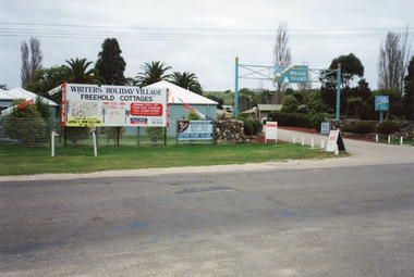 Lakes Entrance Historical Society
Photograph, Holding M, Whiters Camp Park, 1994c
Colour photograph of Whiters Holiday Village, Whiters Street, Lakes Entrance, Victoria, developed on the site that was known as Whiters Camp Park. Shows the entry to the complex between stone fences, advertising boards on fence line, glimpse of cottages and mature trees inside the grounds.tourism, resort, caravan parks -
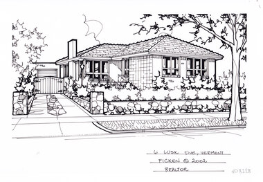 Whitehorse Historical Society Inc.
Artwork, other - Ink Line Drawing, Margaret Picken, 6 Lusk Dve., Vermont, 2002
A property illustration by Margaret Picken Commissioned by a real estate agency for the purpose of advertising 6 Lusk Dve., Vermont This property is listed as having sold for $270,000 in 2004 Made by using Rotring ‘Rapidigraph’ drafting pens with Rotring ink on Rapidigraph polyester drafting film, double matte. Trained as a cartographic draftsman within the mining industry, Margaret Picken is an artist who worked producing property illustrations for real estate agencies in eastern suburbs of Victoria from 1983-2005. Retiring from the industry as technological changes favored coloured photography over illustrations, and commissioning companies over sole contractors.This artwork is of Historical Significance as a record of local domestic architecture.A black ink line drawing on drafters film by Margaret Picken, of a single story brick house. On the left is a driveway leading to a gated garage in the background. While in the right foreground is a low stone fence enclosing a front yard with hedging. There are two hole punch holes just below centre of the upper edge6 Lusk Dve., Vermont Margaret Picken © 2002 Realatorwhitehorse historical society, schwerkolt cottage, housing, architecture, margaret picken, house, garden, real estate, vermont, vermont south -
 Whitehorse Historical Society Inc.
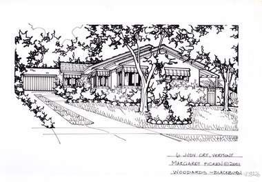
Artwork, other - Ink Line Drawing, Margaret Picken, 6 Judy Crt., Vermont, 2001
A property illustration by Margaret Picken Commissioned by a real estate agency for the purpose of advertising 125 Jolimont Rd., Vermont This property is listed as having sold for $225,500 in 2001 Made by using Rotring ‘Rapidigraph’ drafting pens with Rotring ink on Rapidigraph polyester drafting film, double matte. Trained as a cartographic draftsman within the mining industry, Margaret Picken is an artist who worked producing property illustrations for real estate agencies in eastern suburbs of Victoria from 1983-2005. Retiring from the industry as technological changes favored coloured photography over illustrations, and commissioning companies over sole contractors.This artwork is of Historical Significance as a record of local domestic architecture.A black ink line drawing on drafters film by Margaret Picken, of a black and white line drawing of a single story brick house, with a driveway on the left leading to a connected garage in the background. In the foreground is a front yard with garden beds edged with stone boarders. There are two hole punch holes just below centre of the upper edge6 Judy Crt., Vermont Margaret Picken © 2001 Woodards - Blackburnwhitehorse historical society, schwerkolt cottage, housing, architecture, margaret picken, house, garden, real estate, vermont, vermont south -
 Whitehorse Historical Society Inc.
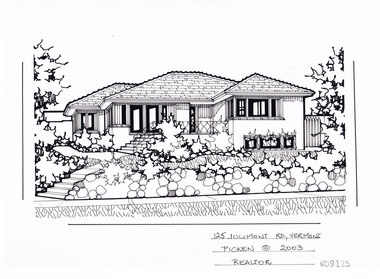
Artwork, other - Ink Line Drawing, Margaret Picken, 125 Jolimont Rd., Vermont, 2003
A property illustration by Margaret Picken Commissioned by a real estate agency for the purpose of advertising 125 Jolimont Rd., Vermont This property is listed as having sold for $351,000 in 2003 Made by using Rotring ‘Rapidigraph’ drafting pens with Rotring ink on Rapidigraph polyester drafting film, double matte. Trained as a cartographic draftsman within the mining industry, Margaret Picken is an artist who worked producing property illustrations for real estate agencies in eastern suburbs of Victoria from 1983-2005. Retiring from the industry as technological changes favored coloured photography over illustrations, and commissioning companies over sole contractors.This artwork is of Historical Significance as a record of local domestic architecture.A black ink line drawing on drafters film by Margaret Picken, of a black and white line drawing of a single story brick house, with steps from the footpath leading up to a raised porch. In the foreground is a stone retaining fence enclosing a front yard with garden bed edging. There are two hole punch holes just below centre of the upper edge125 Jolimont Rd., Vermont Picken © 2003 Realtorwhitehorse historical society, schwerkolt cottage, housing, architecture, margaret picken, house, garden, real estate, vermont, vermont south -
 Bacchus Marsh & District Historical Society
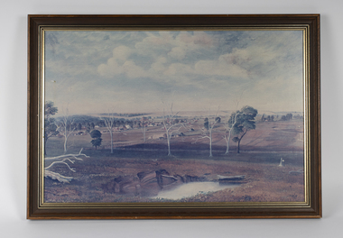
Painting, View of Bacchus Marsh from Stamford Hill circa 1880s
The date of the scene depicted in this painting has not been identified. The painting has no artist signature or date. The view depicted is from an area close to the present day Madden Drive in Bacchus Marsh. The angle of the view suggests the artists viewpoint may have been from a spot close to the intersection of Madden Drive and Muir Street looking east over the town. Several buildings constructed in the 1860s and 1870s can be seen in the painting. These include Saint Andrews Presbyterian Church (now Uniting Church), built 1865, Stone Villa in Bennett Street, the Bacchus Marsh Court House, the former National Bank and the Border Inn, all on Main Street, and in the distance Saint Bernard’s Catholic Church. Buildings such as Simon’s Garage erected in 1913, on the corner of Main Street and Grant Street are not shown. In the foreground running horizontally Grant Street can be seen. The view of Grant Street shows very few buildings. One house in the centre of the picture is Murdoch's Cottage. A brick house constructed in 1868 on the corner of Grant Street and Waddell Street. To the right of the picture along Grant Street no buildings are shown. The store built by John Jory in 1890 at 60-62 Grant Street which survives as a building in 2025 is not shown. Some allowance for artistic interpretation must be allowed but based on what the scene depicts it suggests a scene of Bacchus Marsh in the late 1870s or 1880s. Print reproduction of an oil painting. Framed. Undated. Unsigned. BMDHS Location: AR/B12/Beside (on floor)views bacchus marsh vic., paintings bacchus marsh vic., landscapes bacchus marsh vic. -
 Flagstaff Hill Maritime Museum and Village
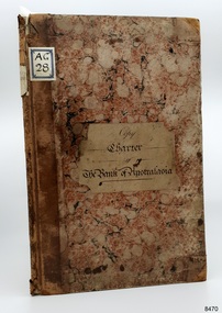
Legal record - Charter, Copy of Charter of Bank of Australasia, 01-10-1867
This Copy of the Charter of the Bank of Australasia originated from the Bank of Australasia. The bank of Australasia was incorporated by Royal Charter of England in March 1834. It had its Australian beginning on 14th December 1835, opening in Sydney. The Acting Superintendent of the bank at that time was David Charters McArthur. He was Superintendent from 1867-to 1876. The Melbourne branch opened on 28th August 1838 in a two-roomed brick cottage on the north side of Little Collins Street, where two huge mastiff dogs were used at night to guard the bank. The government also provided an armed military sentinel. Due to the bank's rapid growth, a new building for the Melbourne branch was opened in 1840 at 75 Collins Street West. By 1879 the bank had been upgraded to a magnificent two-storey building on the corners of Collins and Queens Streets, with the entry on Collins Street. In 1951 the Bank of Australasia amalgamated with the Union Bank to form the Australia and New Zealand Bank, now known as the ANZ. Then in 1970, the ANZ merged with both the ES&A and the London Bank of Australia to form the ANZ Banking Group Limited. The ANZ Banking Group Ltd kindly donated a variety of historic items from the Bank of Australasia. BANK of AUSTRALASIA, WARRNAMBOOL – In 1854 Warrnambool had two banks, the Union Bank and the Bank of Australasia. Later, completely different bank businesses opened; in 1867 the National Bank of Australasia, then in 1875 the Colonial Bank of Australasia. The original Warrnambool branch of the Bank of Australasia was established in July 1854, and operated from a leased cottage on Merri Street, close to Liebig Street. The bank next bought a stone building previously erected by drapers Cramond & Dickson on the corner of Timor and Gibson Streets. Samuel Hannaford was a teller and then Manager at the Warrnambool branch from 1855 to 1856 and the Warrnambool Council chose that bank for its dealings during 1856-57. In 1859 Roberts & Co. was awarded the contract to build the new Bank of Australasia branch for the sum of £3,000; the firm built the Warrnambool Post Office in 1856 and purchased land in Timor Street in 1858. The land was on a sand hill on the northeast corner of Timor and Kepler Streets and had been bought in 1855 from investor James Cust. The new building opened on May 21, 1860. The bank continued to operate there until 1951 when it merged with the Union Bank to form the ANZ Bank, which continued operating from its Liebig Street building. Warrnambool City Council purchased the former Bank of Australasia building in 1971 and renovated it, then on 3rd December 1973 it was officially opened as the Art Gallery by Cr. Harold Stephenson and Gallery Director John Welsh. The Gallery transferred to the purpose-built building in Liebig Street in 1986 and the old bank building is now the Gallery club. Staff at the Bank of Australasia in Warrnambool included the following men but others were also involved: Samuel Hannaford, Teller then Manager from 1855-1856; Hawkins, Manager in 1856, W H Palmer, Manager from January 1857 until November 1869 when the Teller Basil Spence was promoted to Manager; H B Chomley, Manager from April 1873 and still there in 1886; A Butt, Manager in 1895-1904; J R McCleary Accountant and Acting Manager for 12 months, until 1900; A Kirk, Manager 1904; J Moore, staff until his transfer to Bendigo in December 1908; J S Bath was Manager until 1915; C C Cox, Manager until April 1923; Richard C Stanley, Manager 1923 to April 1928. The Copy of the Charter of the Bank of Australasia has significance through its association with the Bank of Australasia. The early Australian bank was established in 1834 by Royal Charter and opened in Sydney, Australia, in Sydney in 1835. The bank had many Australian offices in November 1877, particularly on the east and south coasts. Victoria had 45 per cent of all Offices. The Charter is locally significant for its association with the Warrnambool Bank of Australasia, which was established in 1854. It was Warrnambool Council’s first bank. The bank continued to operate until the organisation's merger in 1951 when it became the ANZ Bank Group today. The Bank was an integral part of the growth of local commerce and the community. Record book, hard cover, tan black and beige pebble-pattern on front and back, and tan reinforced strip on spine with decorative embossing. Handwritten title on cream paper is attached in centre of front cover. Cream paper pages are lined and have watermarks on each one. Pages are numbered up to the last written page, number 35. The last page is sealed in red with an official stamp and dated 1st October 1867. Inscriptions are on three labels. and on front end page, and red oval stamp inside front cover. It is an official copy of the Charter of the Bank of Australasia.Label with title, handwritten in pen "Copy / Charter / of / The Bank of Australasia" Label on spine, typewritten "COPY / CHARTER" Label on front cover, handwritten in pen "A G / 28" Front inside cover, red oval stamp "AUSTRALIA AND NEW ZEALAND BANK LIMITED - ARCHIVES - " and in the oval, in pen "A G / 28" Front end page, handwritten in pencil "Normal Copy 5 Dec No. 74" Front end page, in pencil "L 28"flagstaff hill, warrnambool, shipwrecked coast, flagstaff hill maritime museum, maritime museum, shipwreck coast, flagstaff hill maritime village, great ocean road, bank of australasia, boa, union bank, australia & new zealand bank, anz bank, david charters mcarthur, d c mcarthur, sydney, new south wales, currency, banknote, legal tender, commerce, banking, roberts & co., james cust, heraldic shield, insignia, samuel hannaford, w h palmer, basil spence, h b chomley, a butt, j r mccleary, a kirk, j moore, j s bath, c c cox, richard c stanley, charter of the bank of australasia