Showing 439 items matching "the top shop"
-
 Ringwood and District Historical Society
Letter, Property for sale - Ringwood Shop and Dwelling Estate, Ringwood, Victoria - circa 1925
ID 5225 note: Further information relating to allotments marked on the hand-drawn plan are included in ID 5224 - Ringwood Station Estate.Typewritten letter from A.V. Greenwood with hand drawn plan of Ringwood Shop and Dwelling Estate, detailed description of property for sale, and top and side elevation views of house. (7 pages)(Transcript of first page - to unknown recipient) Phone 988 Central, 331 Canty Greenwood Pty. Ltd. 5 Flinders Street Melbourne. Dear Sir, 1. Attached please find drawings of my house at Ringwood. 2. It is for sale at £4,865 or to let at £5 per week to an approved tenant. 3. I sold it to Mr. De Garis and vacated it, but it is now back on my hands. 4. I leased another place instead of living in my own. I may be able to cancel same; in the meantime, however, I propose to sell or let my own. The painters are now going through the place; re-varnishing, re-oiling and re-polishing so that in about five days it will look "spick and span". 5. The house was specially built under my own supervision. 6. It is very suitable for a high class Guest House, Doctor's residence, Hospital or Convalescent Home. If you know of anyone whom it might suit, please communicate with them. DESCRIPTION 7. It stands on 305 feet of land facing Greenwood Avenue. It is cement, roughcast and hardwood, well oiled, and is now being redone so that the house is as good as new; red tile roof; verandahs three sides; two sleep-outs; five bedrooms; large dining room; very large music room with nooks, upstairs lounge, study; sewing room; built-in wardrobes and cupboards throughout; handsome kitchen with handsome pantry cupboard with drawers and glass front; one bath room; one shower room; wash house with patent copper and laundry. Every modern convenience, hot water system (through copper pipes with large copper cylinder) electric lights everywhere, outside and in, Yan Yean water laid on everwhere throughout house and gardens. Floors throughout are the very best, close set, stained and polished; dainty lead light windows etc. 8. There is a big garage, with tiled roof and two rooms with all conveniences for a married couple. Property is well drained with a system of its own. The house stands upon the top of a hill close to Railway Station, say 500 feet from the Footbridge. 9. The garden has expansive shrubs; sheds; fernery; tennis court. 10. A handsome piece of furniture goes with the house; a combination pantry and storeroom for groceries, milk, bread etc., consisting of drawers, glass and wire doors, as mentioned above. 11. It is within easy distance of Melbourne as it is only two minutes from Ringwood Station, which is a frequent electric train service bringing it within 39 minutes of the City. It is thought better by some to go further out into the country atmosphere and walk a short distance at the end than to go by train 20 minutes then walk 15 to 20 minutes. 12. The price quoted of £4,865 is made up as follows - 305 feet of land @ £5 ... £1,515 Garage and dwelling ... £300 House hot water system, American cupboard ... £2,600 Water, fencing, sheds & drain ... £250 For the lot ... £4,865 Should you require copies of the enclosed drawings I shall be pleased to supply same. 13. Mr. J.B. McAlpin is the local agent, Phone Ring. 7 (after hours Ring. 44) or you may phone me Central 988. 14. The house is south of the line, facing Greenwood Avenue and immediately at the back of Ringwood House, which is also my property. Yours sincerely, A.V. Greenwood (illegible) ..... (Transcript of second page) RINGWOOD SHOP AND DWELLING ESTATE See these letters on plan attached (H.) Ringwood House and Shops on 100 by 150 feet of land fronting Bedford Road 100 feet @ £10 per foot - £1,000 House and shops - £2,400 ... £3,400 Ringwood House consists of Boarding House, (Phone 101) and two shops, mainly brick; 9 inch walls. Will carry another story. Has music room, dining room, entrance halls, 10 bedrooms, large verandahs, all conveniences, hot and cold water, and stands on what will become a most valuable business corner. (F.)(G.) Mr. Greenwood's house, garage and sheds, stands on 307 feet of land fronting Greenwood Avenue. See detailed description attached ... £4,865 (J.) Cottage on Block 81 in William Street ... £750 (K.) Cottage in Pitt Street ... £650 (Total) £9,665 ..... (Description of third page - Subdivision Plan) Drawn by Edyth Greenwood, phone 988 Central. Subdivision includes Station Street, Pitt Street, Bedford Road, Wantirna Road, James Street, William Street (later Kendall Street), Greenwood Avenue, Ellison Street, and Haig Street. Circles denote blocks for sale. Squares denote house properties for sale. Other features marked include location of businesses along Main Street (Maroondah Highway), cool store, railway station, shop and police station on Bedford Road, church on Station Street, site of schoolmaster's residence and State School, and location of proposed public baths -
 Orbost & District Historical Society
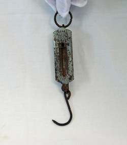
pocket scales, 1920's
The pocket balance was first created in 1770 by Richard Salter in the UK. From the late 18th century onwards these small scales were widely used in markets, grocers and farm shops – wherever people needed to be able to verify the weight of goods to be purchased in order to calculate the correct pricing. Because it was portable, and simple to use, the pocket balance was ideal for weighing goods where accuracy was not required. This balance appears to have been used for weighing fish.Pocket spring scales made of steel. There is a spring fixed at one end with a hook to which an object can be attached at the other. At the top of the scales there. is a metallic ring to fasten the object. This is attached to the main body which on one side has measurements inscribed into the metal surface. Inside the body is a spring loaded mechanism which moves along the scales when weight is added to a hook at the bottom of the shaft.At the top - POCKET BALANCE ARROW and the letters M P inside an oval.scales pocket-balance spring-balance measuring-instrument -
 Orbost & District Historical Society
razor strop, first half 20th century
A razor strop is flexible strip of leather or canvas used to maintain a shaving edge on a thin blade such as a straight razor. Fine powdered jeweler's rouge or other pastes can be added as an abrasive to polish the blade. The strop may be a hanging strip or a hand-held paddle. This one is a hanging strop. Strops were quite commonly found in barber shops and homes before the invention of the safety razor, They are still used for sharpening tool blades. This one was owned and used by Mr Bill Weston, an early Orbost sleeper cutter.This item is an example of the self-reliance shown by rural families when household necessities were not readily available.A brown leather (probably horse hide) razor strop with a double hook at one end. It consists of two strips of leather with padded 'tongue' at bottom. This is a hanging strop which has a metal swivel on top so that the strop can be turned over while hanging from a hook/peg Front top in gold : MALWA Base in gold: 910razor-strop shaving personal-effects -
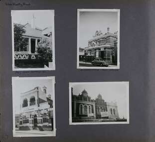
 Ringwood and District Historical Society
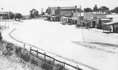
Photograph, Maroondah Highway Central, Ringwood. Whitehorse Rd. Ringwood looking west. 1918
Black and white photograph (3 copies- 2 large, 1 sepia postcard) Typed below one photograph: "Whitehorse Rd. Ringwood looking west - 1918" Image shows a variety of shops on left with a motor vehicle and a horse drawn cart out front. Station Master's house at top left. -
 Flagstaff Hill Maritime Museum and Village
Tool - Router Plane, Late 19th to early 20th Century
Router planes are not the same as modern power routers. The simplest answer is that a router plane is a chisel held at adjustable vertical depths in a block of wood or metal. An antique-style router plane is mainly used for levelling out the bottoms of dado joints, mortises, and when installing hinges, inlays, and tenon cheeks, and similar other uses. There are three main categories or styles of router planes the earliest type of these is affectionately referred to as an "old woman's tooth", or "Grandma's Tooth". These planes can be as simple as a block of wood with the iron wedged in, and some have wedges with brass thumbscrews. Most of these router planes were shop-made tools their bottom flat so they can ride along the top of the wood, and the iron is adjusted to the desired depth by moving it up and down with your fingers.An interesting vintage joinery tool used before mechanical routers with early examples often sought after by collectors today. The subject item was probably made in a joinery workshop for a specific need in regards to producing a specific type of profile. As a result, even though the item appears to be quite old it has no makers mark, age and provenance are unknown.Router Plane Old Woman's Tooth pattern wooden stopper for holding the blade in place. Noneflagstaff hill, warrnambool, shipwrecked-coast, flagstaff-hill, flagstaff-hill-maritime-museum, maritime-museum, shipwreck-coast, flagstaff-hill-maritime-village -
 Marysville & District Historical Society
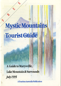
Ephemera (Item) - Tourist Guide, Graeme Haycraft, Mystic Mountains Tourist Guide July 1995, 07-1995
... top shop pancake parlour... caravan park the cumberland igloo roadhouse top shop pancake ...A tourist guide outlining services, accommodation, activities and places of interest to visit in and around Marysville, Lake Mountain and the local district.A tourist guide outlining services, accommodation, activities and places of interest to visit in and around Marysville, Lake Mountain and the local district.Acknowledgements/ Mystic Mountains Tourism Association, Marysville Office of the Dept. of Conser/ vation & Natural Resources, Mrs Elaine Postlethwaite, Ms Sue Henry & every/ advertiser without whose support this Guide would not have been possible.marysville, victoria, australia, tourist guide, mystic mountains, lake mountain, tourism australia, graeme haycraft, magic creek nursery, missing links miniature golf, phelps bakery, blackwood cottages, marysville hotel motel, tower motel, kerami house, marylands guest house, lomatia lodge, willowbank at taggerty, barree mud brick cottages, scenic motel, somerled mountain retreat, dalrymples guest cottages, nanda binya lodge, mathilde's of marysville country guest house, the birches resort, mystic mountains tourist information, marysville caravan park, the cumberland, igloo roadhouse, top shop pancake parlour, the silver birch restaurant, steavenson's restaurant, olde yarra track shoppe, danish coffee gardens, oscars take-away, country touch pottery studio & gallery, cumberland memorial scenic reserve, cathedral range state park, lady talbot forest drive, wishing well, taggerty river picnic area, taggerty river, phantom falls, keppels falls, the beeches walking track, mount sugarloaf, maryton park holiday cottages, snowviews, esa camping & conference centre, wirreanda festival, marysville post shop, hidden talent craft gallery, marysville automotive repairs, geoffrey pope & associates, beauty spot walk, tree fern gully walk, michaeldene track, marysville riding school, gerraty's ski centre, marysville holiday cottages, marysville triangle taxi service, fruit salad farm, lake mountain alpine resort, marysville ski hire, lake mountain ski school, cross country ski hire, lake mountain ski hire, marysville country club -
 Marysville & District Historical Society
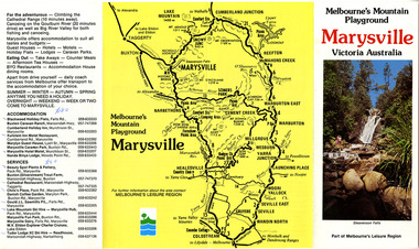
Ephemera (Item) - Tourist Guide, Melbourne's Mountain Playground Marysville Victoria Australia, Unknown
... top shop... marysville drapery shop marysville garage marysville newsagency top ...A fold out tourist guide to Marysville and the surrounding district.A fold out tourist guide to Marysville and the surrounding district.marysville, victoria, australia, steavenson falls, marysville golf club, cathedral range, blackwood holiday flats, cumberland holiday inn, kooringa conference and holiday centre, marylyn guest house, marysville caravan park, marysville hotel motel, nanda binya lodge, scenic motel, tower motel, cathedral restaurant, chris's place, danish coffee garden, tudor lodge roadhouse, buxton trout farm, silverstream trout farm, lake mountain ski hire, marysville fun park, mountain view horse hire, jl gould sawmills, marysville dairy, marysville drapery shop, marysville garage, marysville newsagency, top shop -
 Federation University Historical Collection
Artwork, other - Enamelled punch bowl and ladle, Frederick Gladstone Procter, c1932
Frederick Gladstone PROCTER (1898-1977) This decorative enamelled punch bowl mounted on blackwood pillars drew attention when it was exhibited in a shop window display to attract new students in 1932. The Ballarat Technical Art School was well known for its art metal work which was applied to product, interior and commemorative designs. Students undertook many commissions. A small jewellery and enamelling class was also introduced in 1922. Metal punch bowl (probably nickel silver), with enamelled features on blackwood stand, floating bowl and matching ladle. -
Blacksmith's Cottage and Forge
Dispenser, wrapping paper, Unknown
Used in shops for holding brown paper roll to wrap parcels. Paper was torn off against the metal ;blade on the swing bar.Wooden horizontal beam and vertical cross metal bar holding rod and metal swing bar with wooden top bar. Base is badly scratched and worn paint. Nonbrown paper, parcels, shop keeper, wrapping, shops, shopping -
Blacksmith's Cottage and Forge
Stockings-box
Bacchus Marsh had a prestige Hosiery Factory for a short time approximately 1945/1950. Not known where this pair were made but possibly bought at Shepards shop (written on box).An example of local history, factory and shop.Cream cardboard box containing one pair of used nylon stockings, light brown with a seam on back. One stocking has a ladder and is mended with nail varnish. Re-inforced foot.Side of box-T5 Denier nylons "enchantment 10" Top of box-"Prestige- Parallels" Ultra Sheer Nylons/ Shepards Bacchus Marsh WA/Abox, stockings, prestige, shepards, nylons -
 Gippsland Vehicle Collection
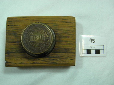
Belsize Wheel Nut, Belsize Motors Limited, Early twentieth century
This wheel nut was found in a long abandoned car yard (Gino's) located in Maffra, Gippsland, and it belonged to a car from the Belsize Motorcar Company (England). A then local man, Frank Straw who found the wheel nut (in 1968) is the grandson of John Hughes. The latter did an apprenticeship as a coachbuilder with the Belsize Company of Manchester, England. He then emigrated (with his wife) to Australia in 1910 and settling in Maffra opened a coachbuilder's shop . He told his grandson that seven Belsize cars came to Australia and that one made its' way to Maffra where John Hughes worked on it at his shop. John Hughes). Old gold coloured Belsize Wheel Nut (metal) and mounted on a rectangular block of wood.Wheel nut is inscribed as follows: BELSIZE in middle of nut surrounded by four (one in each corner) decoration emblems (as seen in photo) surrounded by a gold circle. Around the outside of the circle are the words Belsize Motors Limited -an asterisk at the beginning and end of the company name. Outside the circle at the bottom is the word MANCHESTER. Around the edge of the top of the wheel nut are two gold line circles. -
 Glen Eira Historical Society
Album - Album page, Kambrook Road, Circa 1972
This photograph is part of the Caulfield Historical Album 1972. This album was created in approximately 1972 as part of a project by the Caulfield Historical Society to assist in identifying buildings worthy of preservation. The album is related to a Survey the Caulfield Historical Society developed in collaboration with the National Trust of Australia (Victoria) and Caulfield City Council to identify historic buildings within the City of Caulfield that warranted the protection of a National Trust Classification. Principal photographer thought to be Trevor Hart, member of Caulfield Historical Society. Most photographs were taken between 1966-1972 with a small number of photographs being older and from unknown sources. All photographs are black and white except where stated, with 386 photographs over 198 pages. https://vhd.heritagecouncil.vic.gov.au/places/43737 - re 26 Kambrook Road and 345 Balaclava Road corner building: A prominently situated two-storeyed complex of late Victorian buildings consisting of "Wybar's Buildings" occupying the Balaclava Road/ Kambrook Road corner and the "Caulfield Bakery" facing Kambrook Road, separated by a driveway from a single storeyed shop. The main building has a comer splay and balustraded parapet with curved pediments, the words "Wybar's Buildings 1887" having been obliterated but "Caulfield Bakery 1887" with the characteristic wheatsheaf surviving in raised cement work. The walls are stuccoed and richly ornamented with bracketed cornices and keystones with masks extending to the Bakery. The main building is further distinguished by the Masonic symbol of the mason's dividers in the pediment whilst the upper level of the bakery is in overpainted brickwork. The single storeyed shop incorporates the bracketed cornice and consoles characteristic of the main buildings and is in other respects a utilitarian structure. https://vhd.heritagecouncil.vic.gov.au/places/35413 - re 16 Kambrook Road A small late Victorian Italianate villa distinguished by its parapeted window bays either side of a small verandah with encaustic tiled floor. The parapets are balustraded with console enrichment and glazed tiles, the stuccoed surfaces being unpainted. Ornamentation is in other respects undistinguished. https://www.gleneira.vic.gov.au/services/planning-and-building/heritage/heritage-management-plan - re 9-11 Kambrook Road ... they demonstrate most of the commonly employed aesthetic devices characteristic of the Italianate Style including patterned brickwork, patterned slate roofs, cast iron lace verandahs, ornamental stucco work and ashlar boards...https://vhd.heritagecouncil.vic.gov.au/places/43737 - 345 Balaclava and 26 Kambrook Roads HO91 in City of Glen Eira "Wybar's Buildings" at the corner of Balaclava Road and Kambrook Road are important as a prominent late Victorian commercial development incorporating a variety of activities including a bakery and possibly a coffee palace, the latter understood to be unique within the municipality, but characteristic of the period. It is a rare complex of its type in Caulfield and is important also as evocative evidence of the late Victorian Land Boom and the creation of a small now defunct commercial centre at this location by the George Wybrow. https://vhd.heritagecouncil.vic.gov.au/places/35413 - 16 Kambrook Road HO121 in City of Glen Eira ''Hollywood'' at 16 Kambrook Road is of architectural interest for its pavilions which retain their unpainted parapets and ornamental tiles in the manner of other less imposing examples in the immediate locality possibly linked with the builder George Wybar and his son, who undertook substantial projects nearby. Its association with James Yorston, presumably is Yorston of Dickson and Yorston, important builders and estate developers at Caulfield during the Inter war period is of interest. https://www.gleneira.vic.gov.au/services/planning-and-building/heritage/heritage-management-plan - re 9-11 Kambrook Road HO152 Normanby Road/Kambrook Road, Caulfield North Statement of Significance: The Precinct is historically significant for its capacity to demonstrate standards of design and building construction in this part of the municipality during the late Land Boom years and especially just prior to the bank collapse of 1891. The housing stock is representative of the standards of amenity excepted by the middle classes of Melbourne society at the time, including artists, (horse) trainers, jockeys, managers, travellers, journalists and the like, also having a functional link with the activities of the Caulfield Racecourse which forms an important element in the history of the Municipality. The row of attached pairs at 5-11 Kambrook Road and 53-67 Kambrook Road is especially significant in this respect in that the narrow allotments are indicative of the owner/developer’s determination to maximise profits at the height of the Land Boom in 1891...Page 104 of Photograph Album with four photographs (landscape) of three different properties on Kambrook Road.Handwritten: Kambrook Road [top right] / WYBAR'S BUILDING 1887/ INC CAULFIELD BAKERY / [under top right photo] / 16 KAMBROOK ROAD / 1970 HIRST MRS J.N.[under bottom left photo] / 11-9 KAMBROOK ROAD / 1970 9-BUCKLAND MRS L.A / 11- ATKINS MRS N.E. [under bottom right photo] / 104 [bottom right]trevor hart, kambrook road, victorian, caulfield north, parapets, wybar's buildings 1887, caulfield bakery 1887, architectural features, painted bricks, balaclava road, victorian italianate style, houses, bay windows, verandahs, glazed tiles, shops, george wybar, builders, james yorston, dickson and yorston, j n hirst, l a buckland, n e atkins, patterned slate roofs, patterned bricks, cast iron work, attached houses -
 Glen Eira Historical Society
Album - Album page, Koornang Road, Circa 1972
This photograph is part of the Caulfield Historical Album 1972. This album was created in approximately 1972 as part of a project by the Caulfield Historical Society to assist in identifying buildings worthy of preservation. The album is related to a Survey the Caulfield Historical Society developed in collaboration with the National Trust of Australia (Victoria) and Caulfield City Council to identify historic buildings within the City of Caulfield that warranted the protection of a National Trust Classification. Principal photographer thought to be Trevor Hart, member of Caulfield Historical Society. Most photographs were taken between 1966-1972 with a small number of photographs being older and from unknown sources. All photographs are black and white except where stated, with 386 photographs over 198 pages. 1970 Sands & McDougall Directory shows UFS Dispensary at address.Page 106 of Photograph Album with one photograph (portrait) of a pharmacy on Koornang Road.Handwritten: Koornang Rd [top right] / 162 KOORNANG RD [under photo] / 106 [bottom right]trevor hart, koornang road, carnegie, rosstown, dispensary, pharmacies, shops, commercial establishments, ufs dispensary, arches -
 Glen Eira Historical Society
Album - Album page, Glenmoore, St George's Road, Circa 1972
This photograph is part of the Caulfield Historical Album 1972. This album was created in approximately 1972 as part of a project by the Caulfield Historical Society to assist in identifying buildings worthy of preservation. The album is related to a Survey the Caulfield Historical Society developed in collaboration with the National Trust of Australia (Victoria) and Caulfield City Council to identify historic buildings within the City of Caulfield that warranted the protection of a National Trust Classification. Principal photographer thought to be Trevor Hart, member of Caulfield Historical Society. Most photographs were taken between 1966-1972 with a small number of photographs being older and from unknown sources. All photographs are black and white except where stated, with 386 photographs over 198 pages. From Victorian Heritage Database citation for HO59 Glenmoore, 1 St Georges Road Elsternwick https://vhd.heritagecouncil.vic.gov.au/places/35202 as at 30/10/2020 "Glenmoore" is locally significant as a surviving mid nineteenth century villa residence in the then fashionable bi-chromatic brick form. It is also important as the home of Hugh Moore who built several shops in nearby Glen Huntly Road and which remain as important contributors to the architectural character of the Elsternwick Shopping Centre.Victorian Heritage Database citation HO59 Glenmoore, 1 St Georges Road Elsternwick https://vhd.heritagecouncil.vic.gov.au/places/35202 An imposing two storeyed villa in bichrome brick with two storeyed timber posted verandah, coupled with cast iron lace frieze, spandrels and central tympanum enrichment. The hipped roof is in slate and has a prominent crean1 brick chimney stack forming part of the facade. Openings are flat arched although the entrance is round arched with a fan light. The south elevation has bayed windows. Two storeyed hip roofed additions are sympathetic and attached on the north side and at the rear. Inside, the staircase and stained glasswork with initials "HM" and family coat of arms are important surviving elements. INTEGRITY: Good, timber outbuildings of an early date, mature and spacious front garden includes early palm trees. Alterations include reconstruction of facade verandah including tiled pavement and front door on east side. Interior has a high level of integrity. Original grounds included adjoining "Carramar".Page 178 of Photograph Album with three photographs of Glenmoore, St Georges Road. Handwritten: "Glenmoore" 1 St George's Road [top right] / 178 [bottom right]trevor hart, chimneys, porch, mansion, slate roof, return verandah, stained glass, cast iron frieze, glenmoore, 1860's, hugh moore, glenmoore estate, double storey, elsternwick shops, st george's road, thomas watts, elsternwick, victorian style, protruding bay windows, cast iron work, bi-chromatic bricks, gardens, balconies, moore's buildings, glen huntly road, stairs, house names -
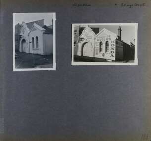 Glen Eira Historical Society
Album - Album page, Old Fire Station, 4 Selwyn Street, Circa 1972
This album was created in approximately 1972 as part of a project by the Caulfield Historical Society to assist in identifying buildings worthy of preservation. The album is related to a Survey the Caulfield Historical Society developed in collaboration with the National Trust of Australia (Victoria) and Caulfield City Council to identify historic buildings within the City of Caulfield that warranted the protection of a National Trust Classification. Principal photographer thought to be Trevor Hart, member of Caulfield Historical Society. Most photographs were taken between 1966-1972 with a small number of photographs being older and from unknown sources. All photographs are black and white except where stated, with 386 photographs over 198 pages. From Victorian Heritage Database citation for H2376 Former Elsternwick Fire Station, 2-4 Selwyn Street Elsternwick - Victorian Heritage Register https://vhd.heritagecouncil.vic.gov.au/places/2645 (as at 21/11/2021) The Former Elsternwick Fire Station was built and commenced operation in 1896. It was one of 32 new fire stations built between 1892 and 1896 by the newly formed Melbourne Metropolitan Fire Brigade ('MFB') to form a comprehensive fire-fighting network across Melbourne. The MFB was established in 1891 as Victoria's government-run fire-fighting service in Melbourne and its growing suburbs. By 1918 motorised fire engine appliances had replaced horse-drawn fire vehicles across the metropolitan area, and the consequently larger areas that fire stations could protect meant the 1896 Elsternwick Fire Station was one of many which was becoming obsolete. The MFB continued to use the Elsternwick Fire Station up until the Station's closure in 1926. From 1927 the former Fire Station was leased by neighbouring timber merchants JJ Webster Pty Ltd who subsequently purchased the property from the MFB in 1934. From 1954 the 'Esquire Motors' car repair business traded at the site, and changes to the former Fire Station building including the complete enclosure of its yard by corrugated steel walls and roofing appear to have been completed in the mid-1950s. In 1990 the Australian Broadcasting Corporation ('ABC') purchased the former Fire Station together with five other adjoining land parcels in Selwyn Street. From that time until 2017 the former Elsternwick Fire Station has been used by the ABC as office and storage space in its Selwyn Street television studio complex.From Victorian Heritage Database citation for H2376 Former Elsternwick Fire Station, 2-4 Selwyn Street Elsternwick - Victorian Heritage Register https://vhd.heritagecouncil.vic.gov.au/places/2645 (as at 21/11/2021) The Former Elsternwick Fire Station is historically significant as one of the 10 remaining fire stations of the original 32 built for the newly established Melbourne Metropolitan Fire Brigade ('MFB') during the four-year period 1892 to 1896. These fire stations were constructed following the establishment in 1891 of the MFB, Victoria's government-run fire-fighting service for metropolitan Melbourne and its growing suburban population. These new stations formed a crucial part of the MFB's fire-fighting network across Melbourne. The Former Elsternwick Fire Station clearly demonstrates the historical development of fire-fighting services in Melbourne, especially the expansion of the newly-formed MFB throughout Melbourne's suburbs during the 1890s. [Criterion A] The Former Elsternwick Fire Station is architecturally significant as a fine example of a late nineteenth century fire station. Constructed shortly after the establishment of the MFB, it displays characteristics of its class of place that remain mostly unchanged from the former Station's historically important period of development and use. A particularly strong element of the Former Elsternwick Fire Station is the large and strikingly-detailed stone horseshoe arch, designed for horse-drawn fire-fighting vehicles, at the street entrance to its fire-engine room. [Criterion D]Page 188 of Photograph Album with two photographs of the old Elsternwick Fire Station.Handwritten: old fire station 4 Selwyn Street [top right] / 188 [bottom right]trevor hart, rendered, 1890's, melbourne metropolitan fire brigade, mfb, fire-fighting, jj webster, timber merchants, esquire motors, car repair, australian broadcasting corporation, abc, selwyn street, brick and stone, asymmetrical facade, anglo-dutch gable, rusticated and smooth-faced limestone, elsternwick fire station, elsternwick, fire station, jj webster pty ltd, motor vehicle repair shops, stone horseshoe arch entrance -
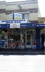 Glen Eira Historical Society
Photograph, Murrumbeena Road, 229, Murrumbeena, 2001
Originally labelled "Beauville Estate, Established 1936, Still Thriving 65 years on, 10th March 2001", the Beauville Estate Album contains colour photographs of houses in the Estate. They were taken around the time of the Beauville Estate’s 65th Heritage Celebration held on 10/03/2001 and donated to the Caulfield Historical Society shortly afterwards. Photographer unknown. From Glen Eira’s Heritage Management Plan by Andrew Ward (1996) Vol 2 p78: In Murrumbeena Road, the shops which form part of the estate are a simple cream brick row relieved by manganese bricks in bands across the upper storeys. City of Glen Eira’s Heritage Management Plan Vol 2 p79 (this is p84 of the pdf version) – HO12 Beauville Estate and environs, Murrumbeena: The Beauville Historic Area is important at the State level as the first large housing estate undertaken by the AV Jennings Construction Co, later Jennings Group Limited, Victoria’s largest home builder. It is important also as a very early estate development incorporating a range of features other than houses and including made roads, shops and recreation facilities. In this respect it was the forerunner of the comprehensively planned housing estate of the post war era. The estate is distinguished by its aesthetic values, as is the earlier and comparable Hillcrest Estate, which are formed by a combination of restrained diversity in house styles, with the exception of no. 30 in the emerging International style, and by a landscaped garden environment. Colour photograph of a section of a double storey, unpainted brick, commercial property containing shops at ground level all with awnings over the footpath. This specific property is a milk bar on street level with plate glass windows and door, colourful advertising and "229' in the top right section of the window. Shop signage says "MURREMBEENA MILK BAR". The upper storey brick residence features a large window, a flat roof and decorative two tone banded brickwork. MURREMBEENA (sic) MILK BAR / PK's / SANDWICH / BAR / MILK BAR & Sandwich Bar / 229 / SUB NEWSmurrumbeena, architectural styles, 1930's, inter war style, a.v. jennings, av jennings, jennings, beauville estate, murrumbeena road, milk bars, commercial establishments, flats, sir albert victor jennings, a v jennings construction co, beauville estate heritage area, glen eira city council, architectural features, jennings group limited, land subdivision, beauville historic area, shops, brick features, window displays, advertising signs, murrembeena (sic) milk bar -
 Glen Eira Historical Society
Album - Album page, Glen Huntly Road, Circa 1972
This photograph is part of the Caulfield Historical Album 1972. This album was created in approximately 1972 as part of a project by the Caulfield Historical Society to assist in identifying buildings worthy of preservation. The album is related to a Survey the Caulfield Historical Society developed in collaboration with the National Trust of Australia (Victoria) and Caulfield City Council to identify historic buildings within the City of Caulfield that warranted the protection of a National Trust Classification. Principal photographer thought to be Trevor Hart, member of Caulfield Historical Society. Most photographs were taken between 1966-1972 with a small number of photographs being older and from unknown sources. All photographs are black and white except where stated, with 386 photographs over 198 pages.Page 62 of Photograph Album with three photographs (one landscape and two portrait) of the Elsternwick Hotel exterior (front, rear and side); plus one of the first floor exteriors for 5 adjacent shops on Glen Huntly Road.Hand written: Glen Huntly Road [top right] / 62 [bottom right] trevor hart, caulfield north, glen huntly road, elsternwick, hotels, elsternwick hotel, shops, glenhuntly road -
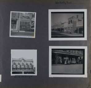 Glen Eira Historical Society
Album - Album page, Glen Huntly Road, Circa 1972
This photograph is part of the Caulfield Historical Album 1972. This album was created in approximately 1972 as part of a project by the Caulfield Historical Society to assist in identifying buildings worthy of preservation. The album is related to a Survey the Caulfield Historical Society developed in collaboration with the National Trust of Australia (Victoria) and Caulfield City Council to identify historic buildings within the City of Caulfield that warranted the protection of a National Trust Classification. Principal photographer thought to be Trevor Hart, member of Caulfield Historical Society. Most photographs were taken between 1966-1972 with a small number of photographs being older and from unknown sources. All photographs are black and white except where stated, with 386 photographs over 198 pages. 376 Glen Huntly Road is a contributory building to HO72 - Elsternwick Estate and Environs, City of Glen Eira.Page 64 of Photograph Album with four photographs of different properties on Glen Huntly Road - 2 in portrait mode and 2 in portrait photographs of photographs.Hand written: Glen Huntly Road [top right] / 376 GLENHUNTLY ROAD [written in blue pen on the bottom edge of the top left photo] / 216-218 Glen Huntly Rd [under bottom left photo] / 64 [bottom right] trevor hart, glen huntly road, elsternwick, shops, streetscapes, vintage cars, carriages and coaches, glenhuntly road -
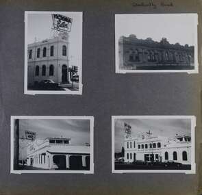
 Glen Eira Historical Society
Album - Album page, Glen Huntly Road, Circa 1972
This photograph is part of the Caulfield Historical Album 1972. This album was created in approximately 1972 as part of a project by the Caulfield Historical Society to assist in identifying buildings worthy of preservation. The album is related to a Survey the Caulfield Historical Society developed in collaboration with the National Trust of Australia (Victoria) and Caulfield City Council to identify historic buildings within the City of Caulfield that warranted the protection of a National Trust Classification. Principal photographer thought to be Trevor Hart, member of Caulfield Historical Society. Most photographs were taken between 1966-1972 with a small number of photographs being older and from unknown sources. All photographs are black and white except where stated, with 386 photographs over 198 pages. The Former Elsternwick Post Office is on the Victorian Heritage Register H0640 with a full significance statement and also HO29 with the City of Glen Eira. Much of the Glen Huntly Road heritage retail strip is heritage listed in HO72 with the City of Glen Eira.Page 67 of Photograph Album with four photographs (three portrait and one landscape) of different properties on Glen Huntly Road - a house, Post Office, ANZ Bank and shops.Hand written: Glen Huntly Road [top left] / 1027 GLEN HUNTLY RD [under top left photo] / ELSTERNWICK POST OFFICE [under top right photo] / 67 [bottom left] trevor hart, glen huntly road, elsternwick, shops, caulfield, post offices, glenhuntly road, banks, brick houses, shopping centres -
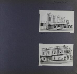 Glen Eira Historical Society
Album - Album page, Gordon Street, Circa 1972
This photograph is part of the Caulfield Historical Album 1972. This album was created in approximately 1972 as part of a project by the Caulfield Historical Society to assist in identifying buildings worthy of preservation. The album is related to a Survey the Caulfield Historical Society developed in collaboration with the National Trust of Australia (Victoria) and Caulfield City Council to identify historic buildings within the City of Caulfield that warranted the protection of a National Trust Classification. Principal photographer thought to be Trevor Hart, member of Caulfield Historical Society. Most photographs were taken between 1966-1972 with a small number of photographs being older and from unknown sources. All photographs are black and white except where stated, with 386 photographs over 198 pages.From: https://vhd.heritagecouncil.vic.gov.au/places/65624 (as of 20/01/2021) National Trust listing for the Classic Cinema Property No. B7027 The Elsternwick Theatre, established in 1911 in an earlier hall, is of Regional historical and social significance. Historically, the Elsternwick Theatre is important as the longest continuously operating cinema in Victoria. However, the building itself was not purpose built as a cinema, and little remains of the early cinema interior. It is also notable as one of a handful of early cinemas in Victoria to still operate. The Elsternwick Theatre is socially significant for its association with cinema, the major form of popular entertainment in the early twentieth century. Prior to the conversion of the premises into a picture theatre in 1911, the building was an important community gathering place; as a public hall and lodge rooms. Architectural interest is restricted to the late Victorian facade, with its relatively unusual three bay arrangement, each topped by large triangular pediments that project beyond the parapet, providing an interesting silhouette.Page 70 of Photograph Album with two portrait photographs (external views) of properties on Gordon StreetHand written: Gordon Street [top right] / CLASSIC THEATRE [under top photo] / 70[bottom right] trevor hart, glen huntly road, gordon street, elsternwick, theatre, corner shops, classic cinema, elsternwick theatre, shops, cars, glenhuntly road, chinese cafes, kum san restaurant, p calandro & co real estate agents -
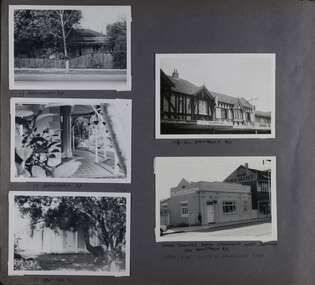 Glen Eira Historical Society
Album - Album page, Hawthorn Road, Circa 1972
This photograph is part of the Caulfield Historical Album 1972. This album was created in approximately 1972 as part of a project by the Caulfield Historical Society to assist in identifying buildings worthy of preservation. The album is related to a Survey the Caulfield Historical Society developed in collaboration with the National Trust of Australia (Victoria) and Caulfield City Council to identify historic buildings within the City of Caulfield that warranted the protection of a National Trust Classification. Principal photographer thought to be Trevor Hart, member of Caulfield Historical Society. Most photographs were taken between 1966-1972 with a small number of photographs being older and from unknown sources. All photographs are black and white except where stated, with 386 photographs over 198 pages. 17 Hawthorn Road, North Caulfield is a contributory building to HO14 Caulfield North and environs, Caulfield North - Heritage Precinct in the City of Glen Eira.Page 83 of Photograph Album with five portrait photographs of 3 different properties on Hawthorn Road. Addresses are handwritten underneath each property.Handwritten: 17 HAWTHORN ROAD [under top left photo] / 17 HAWTHORN ROAD [under middle left photo] / 17 HAWTHORN ROAD [under bottom left photo] / 158-162 HAWTHORN ROAD [under top right photo] // STATE SAVINGS BANK CAULFIELD WEST BRANCH / 144 HAWTHORN RD / WEST SIDE - SOUTH OFF BALACLAVA ROAD [under bottom right photo] / 83 [bottom left] trevor hart, caulfield, hawthorn road, verandahs, houses, shops, banks, state savings bank, caulfield west, caulfield north, tudor style, victorian style -
Glen Eira Historical Society
Medal - ELSTERNWICK CHAMBER OF COMMERCE
This file contains three items: 1/A newsletter for the abovementioned titled ‘Friendly Glenhuntly Road, Elsternwick’ dated September 1981. The newsletter covers topics such as Advertising for Christmas, Caulfield Council elections, shop trading hours, Caulfield High School’s Dutch auction and membership numbers. Because of the original September issue of the newsletter having gone missing in transit and the need for a replacement newsletter, a number of new items and advertising have been omitted for which an apology is offered. 2/A small round metal medallion inscribed with the words ‘Elsternwick Shoppers’ League member’ on one side with a small hole punched through at the top. Age unknown. 3/An envelope in which the medallion is held which has written on it ‘Elsternwick Shoppers’ League Member’s Medallion’ and ‘Donor M. Bromfield’.elsternwick, glenhuntly road, chambers of commerce, elsternwick chamber of commerce, elsternwick shopping centre, caulfield council, city of caulfield, caulfield high school, caulfield rsl, st georges road, victorian chamber of commerce and industry, v.c.c.i., durant bev, summers greg, keeper len, currie john, moore hedley, southern cross newspaper, rudzki brian cr, baxter bob cr, ford dorothy cr, campbell jock cr, mayors, council of affiliated chambers, specialist retailers association, parents clubs, schmidt david, schmidt lyne, schmidt steven, elsternwick shoppers’ league, bromfield m, shopping centres, retail trade, shops, harrower john, petrol stations -
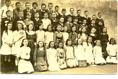 Federation University Historical Collection
Photograph - Photograph - Sepia, Students of Humffray Street State School No. 34, 1917, 1917 (original) 2112 (digital copy)
Ivy Wilson left Humffray Street State School and as a 12 year old enrolled at the Ballarat School of Mines Technical Art School. She studied Art there from 1920 to 1922. Ivy Wilson later became a successful dressmaker and was able to make her own patterns. Ivy's father was an orthopedic bootmaker. They lived at 17 Mair St. and his shop was an underground section.Sepia photograph showing a number of student of Ballarat's Humffray Street State School Grade Five pupils. The girl kneeling 4th from the right is Ivy Wilson.ballarat school of mines, ballarat technical art school, art, dressmaking, wilson, school, education -
 Federation University Historical Collection
Photograph - Newspaper, Ballarat School of Mines and Industries and Junior Technical School double page newspaper article, 25/08/1934
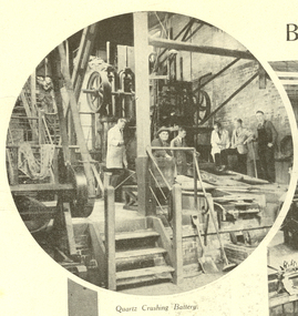
The Ballarat School of Mines was the first school of technical education in Australasia.Double page, double sided, newspaper article from The Weekly Times with 10 images and captions depicting scenes within the School of Mines and Industries, Ballarat Technical Art School and Junior Technical School, Ballarat. Verso: Top Half page: 5 photographs on Callawadda, A pastoral district near Glenorchy Verso Bottom Half page: large photograph of boys attending the Junior technical school at Ballarat Verso Right hand page: 7 "Intersting photographs from England, Scotland and The United StatesSide A: Magazine- Section 8, The Weekley Times, Heading and captions, torn lower left corner to centre, small tears throughout especially left hand side and centre fold, Side B: the weekly times, school of mines and industries, scientific instruments, junior technical school, ballarat, smb, ballarat school of mines, university of ballarat, 1934, callawadda, glenorchy, boys, hutchings, mr j. c. hutchings j.p., state school, bryn avon homestead, broadcasting, mrs hutchings, sheep, xray, cancer treatment, northern belle, loch lomond, oxford college, red lion brewery, aldershot tattoo, siege of namur, battleship, idianapolis battleship, new york, quartz crushing battery, machine shop, pottery, electrical engineering, art department, dressmaking, building, woodwork, assaying, laboratory, architectural drawing, engineering drawing, drawing, assay, drawing from the antique, plaster casts, assay room, ballarat technical art school, bicycles -
 Federation University Historical Collection
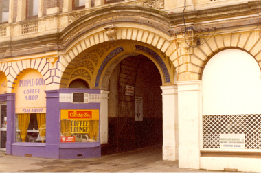
Photograph - Colour, Ballarat Mining Exchange, c1975
Three colour photographs of the Ballarat Mining Exchange in Lydiard Street North, Ballarat.ballarat mining exchange, stockbrokers, share trading, signwriting, purple and gold coffee shop -
 Federation University Historical Collection
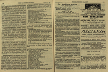
Newspaper, The Machinery Market, 02/12/1889
It's assumed that this journal was read at the Ballarat School of MinesA small illustrated journal with advertisements and pictures. pages 328-356 (and 26 pages of illustrated advertisements). Illustrations include machinery, corn crushers, condensers, chlorination plants. stea, hammers, steam engines, steam pumps, lamps, saw bench, leather belting, casks, barrels, machinery, boiler, cohran and co, birkenhead, stern, cowles syndicate company, electric smelting works, aluminium manufacturing, w t glover and co, rope machine, steam travelling crane, webster wood fibre machine, automatic govenor expansion gear, international exhibition edinburgh, beacon light, air propeller, well boring tools and pumps, cochran and co.'s launch, tug and boat building yard, s.s. jeanette, cochran boiler, cochran and co's boiler shop, stern wheel steamer, s.s. esperanca, cowles syndicate co, milton, w.t. glover & co.'s patent compound rope making machine, bendh drilling machine, steam launch, bicycle, well-boring tools -
 Federation University Historical Collection
Booklet - Exercise Book, Sebastopol Mines and Socialism
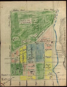
Sebastopol is a suburb of Ballarat..1) Black notebook with red spine .2) hand drawn map showing location of Sebastopol minesHandwritten pageswilliam robertson, new lady don company, kohinor company, leviathon company, newington, copenhagen company, hand in hand company, tannery ground, ballarat freehold company, rough and ready company, park company, inkerman alluvial lead, band & albion consols, gravel pits lead, robert gay, sebastopol mines, ballarat east, alluvial, dalton's flat, canadian gully, red streak, montezuma company, great republic company, golden point, gravel pits, j. hardy, scott's boot shop, lady don company, cgt -
Federation University Historical Collection
Booklet, Scarsdale History Committee, Scarsdale Reminiscences 1906 - 1981, c1981
This booklet was prepared for the 75th reunion of the old scholars of Scarsdale Primary School 980.White covered booklet of 23 pages. Topics include Borough council, Scarsdale Primary school, churches, Newtonw, reunions, Walker's Blacksmith Shop, Aisbett-Young Family tree, Memorial Gatesscarsdale primary school, newtone, aisbett, scarsdale old-boys reunion, hugh wrigley, roy daniel, edward cunningham, arthur hatfield, isabella merry, frederick wrigley, family history -
 Federation University Historical Collection
Photograph - Photograph - Colour, Views of the Former Sutton Music Warehouse, 2009, 09/11/2009
The former Sutton's Music Store later became the Gas and Fuel Shop, Origin Energy, followed by Portico on Sturt. The store was started by Richard Sutton, and was later run by his sons, including inventor Henry Sutton. Views of the former Sutton's Music Store in Sturt Street Ballarat, including stained glass windows, interior detail, exterior views and nearby buildings including the Ballarat Mechanics' Institute.sutton, sutton's music, henry sutton, ballarat mechanics' institute, richard sutton, stained glass -
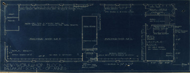 Federation University Historical Collection
Plan, New Workshop Block Ballarat School of Mines
It is not known which building these plans belong to. Since there is a Heat Treatment Room and a number of vices it may be a metalwork room, and may be related to Repatriation classes after World War One. Blueprint of plans for a new workshop at the Ballarat School of Mines. The plan includes a lecture room, bulk store, tool store, heat treatment room, office and two machine shops. Around the machine shops are work benches and vyces (sic)new workshop block, ballarat school of mines, repatriation, buildings