Showing 243 items matching "town square"
-
 Kew Historical Society Inc
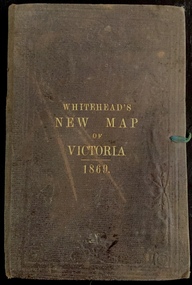
Map, Whitehead's Map of Victoria, With Alphabetical Key, 1869, 1869
When E. Whitehead's New Map of Victoria was released in 1869, an advertisement in the Bendigo Advertiser (16 July 1869) noted that: "This beautifully engraved Map has been revised and brought down to the present time; and, with the Alphabetical Key, is the most complete and the cheapest Map ever published; Price, 6d plain; 1s colored; 2s 6d in case; on linen, post free, 2d extra. E.. WHITEHEAD and CO, Publishers, 67 Collins-street east." The following year, 1870, Whitehead's promoted the edition in the Portland Guardian and Normanby General Advertiser (3 January 1870), advising that: "WHITEHEAD'S NEW MAP OF VICTORIA, 1869 ... is corrected to the latest date, and around is arranged an Alphabetical Key, with Post Towns and Money Order Olffices marked. The Map being divided into squares and numbered, by reference to the Key any place can be found immediately. Price Is beautifully colored, or mounted on linen in case, 2s 6d. Post free, 2d extra, in Victoria. B. Whitehead and C0., Puolishers, 67 Collins-street East, Melbourne". In the same edition of the Portland Advertiser, they also promoted their business generally, saying: "E WHITEHEAD and Co., Stationers, Engravers, Lithographers, 67 Collins street East, execute every description of Lithographic PRINTING, BILL-HEADS. NOTE Headings. Business Dies Engraved and Embossed on Envelopes &c. ARMS, MONOGRAMS, AND CRESTS Engraved and Embossed in Colour, superior to any other house in the Colony. Specimens, post free, 2d. Lithographers, &c, to H.R.H. the Duke of Edinburgh, and Die-inkers and Embossers to His Excellency Sir J. H. T. Manners-Sutton, K C.B. Orders executed for the Trade". Whitehead’s New Map of Victoria 1869 is is an important record of region created towards the end of the Victorian Gold Rush (1851-1869). In addition to its historical significance, this is a rare map, of which the only known copies in Australian public collections are those held at the National Library of Australia, the State Library of Victoria, State Library of New South Wales and the University of Queensland Library.Map of Victoria with gold mining areas, notes on topography, transport routes. Relief shown by hachures. List of towns with distance from Melbourne in map margin. [Melbourne] : Printed & Published by ... E Whitehead & Co ... 67 Collins Street East, 1869 1 map : col., mounted on linen ; 38.4 x 55.4 cm, folded to 18 x 12 cm.Cover "WHITEHEAD'S NEW MAP OF VICTORIA 1869"maps - victoria - 1860s, e whitehead's new map of victoria 1869, whitehead's map of victoria with alphabetical key 1869, cartography, gold rush -
![View of the township of Golden Square / [by] Nicholas Caire, circa 1876](/media/collectors/550653872162f11fb04854aa/items/578340aed0cdd1176c6899f4/item-media/5783411dd0cdd1176c68c568/item-fit-380x285.jpg) Kew Historical Society Inc
Kew Historical Society IncPhotograph, Anglo-Australasian Photographic Company, View of the township of Golden Square, c. 1876
Nicholas Caire was born on Guernsey in the Channel Islands in 1837. He arrived in Adelaide with his parents in about 1860. In 1867, following photographic journeys in Gippsland, he opened a studio in Adelaide. From 1870 to 1876 he lived and worked in Talbot in Central Victoria. In 1876 he purchased T. F. Chuck's studios in the Royal Arcade Melbourne. In 1885, following the introduction of dry plate photography, he began a series of landscape series, which were commercially successful. As a photographer, he travelled extensively through Victoria, photographing places few of his contemporaries had previously seen. He died in 1918. Reference: Jack Cato, 'Caire, Nicholas John (1837–1918)', Australian Dictionary of Biography.An original, rare photograph from the series 'Views of Victoria: General Series' by the photographer, Nicholas Caire (1837-1918). The 60 photographs that comprise the series were issued c. 1876 and reinforced a neo-Romantic view of the Australian landscape to which a growing nationalist movement would respond. Nicholas Caire was active as a photographer in Australia from 1858 until his death in 1918. His vision of the Australian bush and pioneer life had a counterpart in the works of Henry Lawson and other nationalist poets, authors and painters.‘View of the township of Golden Square’ : Views of Victoria (General Series) No.57 : Albumen silver photograph | Photo on card with Title and Description on reverse | Mounted 24 x 30 cm; Photo 12 x 17 cm.On Reverse: ‘This Township is situated in the Bendigo district, on the road to Castlemaine, and although it is of little importance as a business town, is nevertheless of large importance in consequence of the great number of Quartz Reefs it contains. Almost every house is undermined, and large fortunes have been made by the proprietors. The Church in the distance is that of the Wesleyan body. It was in this township that gold was first discovered in the district of Bendigo.’nicholas caire (1837-1918), golden square (vic), bendigo (vic), gold mining, landscape photography - victoria -
 Glen Eira City Council History and Heritage Collection
Book, 2015 ANZAC Centenary Poppies Community Project Book, 2015
The 2015 ANZAC Centenary Poppies community project was run by Glen Eira City Council, community artists and the Glen Eira community. Glen Eira Council encouraged community involvement by inviting the community to handmake poppies (knitted, crocheted, felted or crafted, no more than 15cm in diameter) to be included in a display in the Town Hall’s gallery from April the 8th. The Poppies Community Project Display will be held from 8th April - 17th May 2015 in the Gallery Annexe at Glen Eira Town Hall, with the hundreds of poppies arranged and linked by artist Emma Davies. The display was accompanied by a display of war memorabilia and artefacts, and visitors were invited to record their own dedication in a commemorative book.This large, black book is embossed with the square logo for the City of Glen Eira on the front. It contains tributes and dedications made by members of the community as part of the 2015 ANZAC Centenary Poppies community project under the headings "Date / Name / Dedication". The object also includes an unattached handwritten letter, and a handwritten label attached to one dedication. The dedication entries are dated from 10/04/2015 to 17/05/2015. -
 Sunbury Family History and Heritage Society Inc.
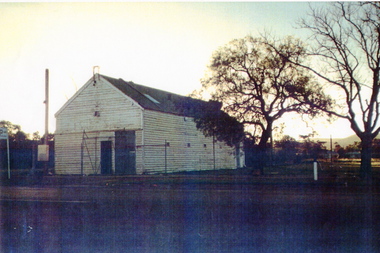
Photograph, c 1940s
The building was the former Sunbury Fire Station. It was in Evans Street on the site where the shopping square has been built. Mount Holden can be seen in the background. A newer building was built for the CFA on the opposite side of Evans Street and closer to Macedon Street. As the shopping centre expanded and Sunbury grew, the CFA moved from the town centre to a site in Jackson Street and another one in Elizabeth Drive.Over the years the CFA has played an important role in numerous fire fighting activities over summer months.A scanned coloured photograph with a fine white border of an old weatherboard building with a metal roof by an unmade roadway. A hill is in the background and two bare trees are growing near the building.sunbury cfa. -
 Beechworth Honey Archive
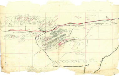
Hand-Drawn Map Centred on Worouly by Frank Lebbell Frost December 1916
This is one of the maps drawn by Frank L. Frost while he was beekeeping in North-East Victoria. This particular map may be reference in the "Wooden" Diary on page 10.Hand-drawn map centred on Whorouly and showing other towns, including Oxley, Byrne, Edi and Whitfield. Details the local flowering eucalypts. Scale is each red square equals three miles. Drawn with black pen and grey lead on paper. Grid and other features are marked in red.hand drawn, hand-drawn, map, oxley, byrne, whitfield, edi, frost, beekeeping, beechworth honey -
 Surrey Hills Historical Society Collection
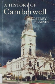
Book, A history of Camberwell, 1980
In 1964 Camberwell City Council commissioned Professor Geoffrey Blainey to first write this history. Since that time, many changes have taken place and therefore the Council asked Professor Blainey to bring the book up to date. Bibliography, includes index. The author presents a century of pioneering development and endeavours. He has traced the coming of the wood-cutters and the farmers, the transition from rectangular paddocks to a grid of roads and streets, the growth from shire to borough, town and city, the filling up of thirteen squares miles into residential suburbia - in successive waves of invasion, along new transport routes - including the Outer Circle Railway. Substantial chapters cover the War Years and the progress of Camberwell since the 1960s have also been included in this edition. 134p; ill;camberwell, victoria, market gardens, tolls, railways, mayors, boroondara road board, borondara shire, councillors, (mr) (prof) geoffrey blainey -
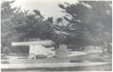 Port Fairy Historical Society Museum and Archives
Photograph
One of the large cannons located in Port Fairy in reply to the threat from foreign invaders. Originally located in the fort on Battery Hill they migrated to various destinations around the town. One of the two originally located at King George Square found its way to the gardens where it occupied several locations before resting at the car entrance to the Gardens - possibly when the Avenue of Honour was planted in Bourne Avenue. A great favororite with the kids of the town, both have now been returned to their original location where they are currently having their carriages refurbished.Black and white Photograph of a large cannon on a carriage in the Botanical Gardensgardens, cannon, botanical, gun -
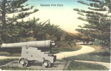 Port Fairy Historical Society Museum and Archives
Postcard, Gardens, Port Fairy
One of the large cannons located in Port Fairy in reply to the threat from foreign invaders. Originally located in the fort on Battery Hill they migrated to various destinations around the town. One of the two originally located at King George Square found its way to the gardens where it occupied several locations before resting at the car entrance to the Gardens - possibly when the Avenue of Honour was planted in Bourne Avenue. A great favororite with the kids of the town, both have now been returned to their original location where they are currently having their carriages refurbished.PhotographGardens Port Fairygardens, cannon, botanical, port fairy -
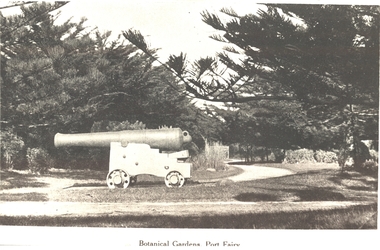 Port Fairy Historical Society Museum and Archives
Photograph, Botanical Gardens Port Fairy
One of the large cannons located in Port Fairy in reply to the threat from foreign invaders. Originally located in the fort on Battery Hill they migrated to various destinations around the town. One of the two originally located at King George Square found its way to the gardens where it occupied several locations before resting at the car entrance to the Gardens - possibly when the Avenue of Honour was planted in Bourne Avenue. A great favorite with the kids of the town, both have now been returned to their original location where they are currently having their carriages refurbished. The Port Fairy Botanical Gardens were formed in 1856 making it one of the earliest gardens in Victoria. The first curator was James Prior, he was paid fifty-two pounds per annum. He was an outstanding curator having been apprenticed to the trade in England at the age of 12, his brother Edward in later years was the Curator of the Koroit Gardens. Prior retired in 1903. During the years of his curatorship Port Fairy was said to have the best gardens outside the city of Melbourne, he was constantly in touch with Baron Von Mueller and later Guilfoyle of the Royal Botanical Gardens of Melbourne. In the early years plants from all over the world were planted here with varying rates of success many of them sent by Baron Von Mueller. In the 1930’ and 40’s the gardens were still very beautiful, and the curator was Roy Manuell. The beautiful iron gates at the entrance were destroyed in the 1946 floods and were replaced in 1989 using some of the material from the original gates. From the 1950’s on the gardens went into a state of decline, much being taken up by the caravan park until in 1986, after a public meeting ‘Friends of the Gardens’ was founded when the entrance section was restored. Black & white photograph of the Large cannon situated in the Botanical GardensBotanical Gardens Port Fairybotanical, garden, cannon -
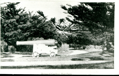 Port Fairy Historical Society Museum and Archives
Photograph
One of the large cannons located in Port Fairy in reply to the threat from foreign invaders. Originally located in the fort on Battery Hill they migrated to various destinations around the town. One of the two originally located at King George Square found its way to the gardens where it occupied several locations before resting at the car entrance to the Gardens - possibly when the Avenue of Honour was planted in Bourne Avenue. A great favororite with the kids of the town, both have now been returned to their original location where they are currently having their carriages refurbished.Black and white photograph of cannon situated in botanical gardensBotanical Gardens Port Fairycannon, gardens, botanical -
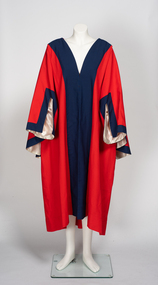 City of Greater Bendigo - Civic Collection
Ceremonial object - Robe, Blashki & Sons, c. 1990's
Red loose fitting ceremonial robe with contrasting broad band of blue fabric on lapel and collar. Square cut sleeves lined with cream fabric. Blashki & Sonsblashki & sons, city of greater bendigo ceremonial item -
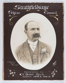 City of Greater Bendigo - Civic Collection
Photograph - Portrait of Councillor Keck, W H Robinson, c 1913
The district of Strathfieldsaye was proclaimed in 1861 and named a Shire on the 17th September in 1866. It remained a shire until amalgamation in 1994 when it became part of the City of Greater Bendigo. The shire was located 8 km to the south- east of Bendigo and covered an area of 601 square kilometres and extended from the Calder Highway to the Coliban and Campaspe Rivers. The shire's administration centre was in Strathfieldsaye until 1972 when new offices were opened in Kennington.Framed black and white head and shoulder portrait of Councillor Keck with hand coloured and drawn detail. Profile slightly to right with walrus moustache. Cut oval brown mount decorated with text and flowers. Hand written title top and lower centre.Strathfieldsaye / Shire Council / W.H. Robinson / Photo / Bendigo / J.H.E Gribbs / Presented by / Cr Herbert Keck / President 1903-4. 1912-13.shire of strathfieldsaye, councillor keck, strathfieldsaye shire council, president of strathfieldsaye shire -
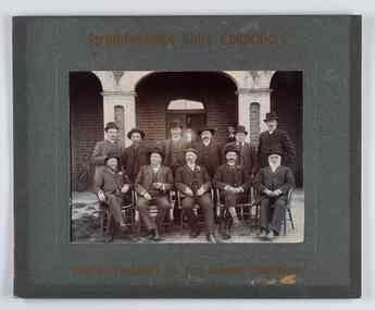 City of Greater Bendigo - Civic Collection
Photograph - Councillor group portrait, W H Robinson, Strathfieldsaye Shire Council, 1909
The district of Strathfieldsaye was proclaimed in 1861 and named a Shire on the 17th September in 1866. It remained a shire until amalgamation in 1994 when it became part of the City of Greater Bendigo. The shire was located 8 km to the south- east of Bendigo and covered an area of 601 square kilometres and extended from the Calder Highway to the Coliban and Campaspe Rivers. The shire's administration centre was in Strathfieldsaye until 1972 when new offices were opened in Kennington.Photographic group portrait of eleven Strathfieldsaye Shire Councillors in front of the Strathfieldsaye Shire Hall. Five men are seated and six standing with one man standing further in back ground on the building's verandah. Photograph is attached directly to green mount card and framed. Gold lettering on mount.Strathfieldsaye Shire Councillors / R. B. Brennan (Sec.) W. J. Lowdes S. Doak M. Burns () N Condon B. Code (Inspector) / WH Robinson Photo Bendigo / T Somerville / W. I. Long / Fred Osborne (President) H Keck / W Dresler / With the President's (Cr. Fred Osborne) Compliments / September 23rd, 1909shire of strathfieldsaye, strathfieldsaye shire council, president of strathfieldsaye shire, strathfieldsaye shire hall -
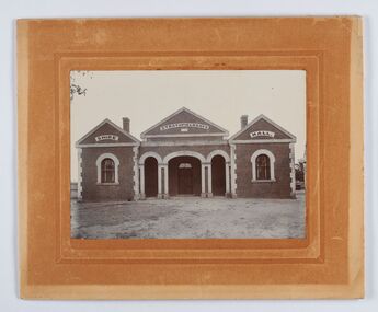 City of Greater Bendigo - Civic Collection
Photograph - Strathfieldsaye Shire Hall
The district of Strathfieldsaye was proclaimed in 1861 and named a Shire on the 17th September in 1866. It remained a shire until amalgamation in 1994 when it became part of the City of Greater Bendigo. The shire was located 8 km to the south- east of Bendigo and covered an area of 601 square kilometres and extended from the Calder Highway to the Coliban and Campaspe Rivers. The shire's administration activities were centred at the Strathfieldsaye Shire Hall which was built in 1869 at a cost of £700 based on a design by George Steane, the shire surveyor and built by George Pallett of Sandhurst. Constructed of red brick, the hall has a unique ventilation system with hollow walls open at the top and bottom to ensure a draught to cool the building in summer. Framed and mounted photograph of the Strathfieldsaye Shire Hall. Verso; W M Robinson / Photographer / Mundy Street Bendigostrathfieldsaye shire hall, shire of strathfieldsaye, strathfieldsaye shire council -
 City of Greater Bendigo - Civic Collection
Photograph - Councillor group portrait, W H Robinson, Strathfieldsaye Shire Council
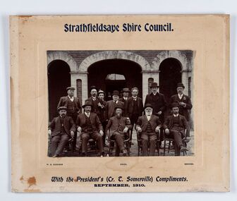
The district of Strathfieldsaye was proclaimed in 1861 and named a Shire on the 17th September in 1866. It remained a shire until amalgamation in 1994 when it became part of the City of Greater Bendigo. The shire was located 8 km to the south- east of Bendigo and covered an area of 601 square kilometres and extended from the Calder Highway to the Coliban and Campaspe Rivers. The shire's administration centre was in Strathfieldsaye until 1972 when new offices were opened in Kennington. Group portrait of 13 men / councilors, 5 seated and 8 standing dressed in suits. There are another 2 men further back in front of the hall doors. Photograph is taken outside the Strathfieldsaye Shire Hall.Srathfieldsaye Shire Council. / With the President's (Cr T. Somerville) Compliments. / September, 1910 / W.H. Robinson Photo. Bendigo Verso; William Drechslershire of strathfieldsaye, president of strathfieldsaye shire, strathfieldsaye shire council -
 City of Greater Bendigo - Civic Collection
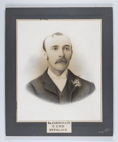
Photograph - Portrait of Councillor Orr, The Yeoman Studios, Ex. Councillor / F. Orr / Eppalock
The district of Strathfieldsaye was proclaimed in 1861 and named a Shire on the 17th September in 1866. It remained a shire until amalgamation in 1994 when it became part of the City of Greater Bendigo. The shire was located 8 km to the south- east of Bendigo and covered an area of 601 square kilometres and extended from the Calder Highway to the Coliban and Campaspe Rivers. The shire's administration centre was in Strathfieldsaye until 1972 when new offices were opened in Kennington. Eppalock Ward is one of three wards in the Greater Bendigo municipality which includes the former Strathfieldsaye Shire. Framed black and white head and shoulder portrait with hand coloured detail. Man with profile slightly to right, walrus moustache, image encircled. Photograph is attached to mount card. Hand written title lower centre.Ex. Councillor / F. Orr / Eppalock / The / Yeoman / Studiosshire of strathfieldsaye, councillor orr -
 City of Greater Bendigo - Civic Collection
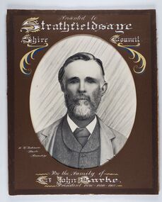
Photograph - Portrait of Councillor Burke
The district of Strathfieldsaye was proclaimed in 1861 and named a Shire on the 17th September in 1866. It remained a shire until amalgamation in 1994 when it became part of the City of Greater Bendigo. The shire was located 8 km to the south- east of Bendigo and covered an area of 601 square kilometres and extended from the Calder Highway to the Coliban and Campaspe Rivers. The shire's administration centre was in Strathfieldsaye until 1972 when new offices were opened in Kennington. Framed black and white head and shoulder portrait of Councillor Burke with hand coloured and drawn detail. Profile centre facing with beard. Cut oval brown mount decorated with text and fscrolls. Hand written title top and lower centre. Wooden frame with detail and gold inner.Presented to Strathfieldsaye / shire Council / w. H. robinson / Photo / Bendigo / By the family of / Cr John Burke / President 1890 - 1899 - 1900strathfieldsaye shire council, councillor burke, president of strathfieldsaye shire -
 City of Greater Bendigo - Civic Collection
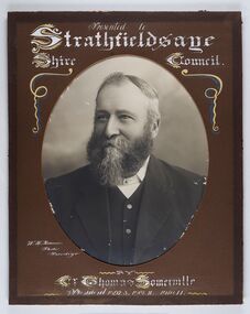
Photograph - Portrait of Councillor Thomas Somerville, W H Robinson
The district of Strathfieldsaye was proclaimed in 1861 and named a Shire on the 17th September in 1866. It remained a shire until amalgamation in 1994 when it became part of the City of Greater Bendigo. The shire was located 8 km to the south- east of Bendigo and covered an area of 601 square kilometres and extended from the Calder Highway to the Coliban and Campaspe Rivers. The shire's administration centre was in Strathfieldsaye until 1972 when new offices were opened in KenningtonFramed black and white head and shoulder portrait of Councillor Somerville with hand drawn detail. Profile slightly to left, face has full beard. Cut oval brown mount decorated with text and scrolls. Hand written title top and lower centre.Presented to / Strathfieldsaye / Shire Council / W. H. Robinson / Photo / Bendigo / by / Cr Thomas Somerville / President 1892 - 3. 1901.2. 1910.11 strathfieldsaye shire council, councillor somerville, president of strathfieldsaye shire -
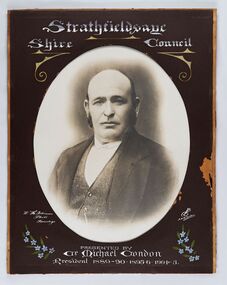 City of Greater Bendigo - Civic Collection
Photograph - Portrait of Councillor Michael Condon, W H Robinson
The district of Strathfieldsaye was proclaimed in 1861 and named a Shire on the 17th September in 1866. It remained a shire until amalgamation in 1994 when it became part of the City of Greater Bendigo. The shire was located 8 km to the south- east of Bendigo and covered an area of 601 square kilometres and extended from the Calder Highway to the Coliban and Campaspe Rivers. The shire's administration centre was in Strathfieldsaye until 1972 when new offices were opened in KenningtonFramed black and white head and shoulder portrait of Councillor Condon with hand coloured and drawn detail. Profile slightly to left. No facial hair. Cut oval brown mount decorated with text, scrolls and flowers. Hand written title top and lower centre.Strathfieldsaye / Shire / Council / W. H. Robinson / Photo / Bendigo / JMB Gribble / Presented by / Cr Michael Condon / President 1889 - 90. 1895-6. 1904 - 5strathfieldsaye shire council, president of strathfieldsaye shire, councillor condon -
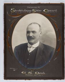 City of Greater Bendigo - Civic Collection
Photograph - Portrait of Councillor Doak, W H Robinson
The district of Strathfieldsaye was proclaimed in 1861 and named a Shire on the 17th September in 1866. It remained a shire until amalgamation in 1994 when it became part of the City of Greater Bendigo. The shire was located 8 km to the south- east of Bendigo and covered an area of 601 square kilometres and extended from the Calder Highway to the Coliban and Campaspe Rivers. The shire's administration centre was in Strathfieldsaye until 1972 when new offices were opened in Kennington.Framed black and white head and shoulder portrait of Councillor Doak with hand coloured and drawn detail. Left facing profile with walrus moustache. Cut oval brown mount decorated with text and scrolls. Hand written title top and lower centre.Presented to / Strathfieldsaye Shire Council / W. H. Robinson / Photo / JMB Gribble / by Cr S. Doak / President 1911 - 1912strathfieldsaye shire council, president of strathfieldsaye shire, councillor doak -
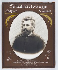 City of Greater Bendigo - Civic Collection
Photograph - Portrait of Councillor Sibley, W H Robinson
The district of Strathfieldsaye was proclaimed in 1861 and named a Shire on the 17th September in 1866. It remained a shire until amalgamation in 1994 when it became part of the City of Greater Bendigo. The shire was located 8 km to the south- east of Bendigo and covered an area of 601 square kilometres and extended from the Calder Highway to the Coliban and Campaspe Rivers. The shire's administration centre was in Strathfieldsaye until 1972 when new offices were opened in KenningtonFramed black and white head and shoulder portrait of Councillor Sibley with hand coloured and drawn detail. Profile slightly to left with walrus moustache and beard. Cut oval brown mount decorated with text, flowers and scrolls. Hand written title top and lower centre.Strathfieldsaye / Shire Council / W m Robinson / Photo / Bendigo / J N B Gribble / Cr Robert R Sibley / First President Chairman of the Road Board 1865 - 5 / President 1866 - 1869 / With Mrs Sibley's Complimentsstrathfieldsaye shire council, councillor sibley, president of strathfieldsaye shire -
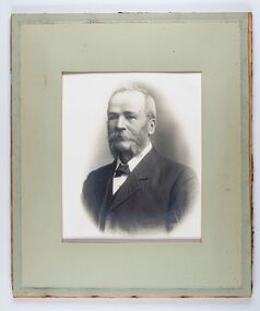
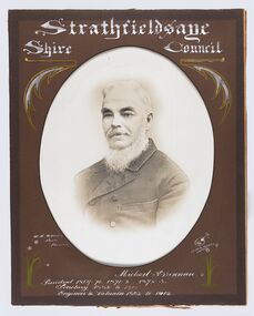 City of Greater Bendigo - Civic Collection
Photograph - Portrait of Councillor Brennan, W H Robinson
The district of Strathfieldsaye was proclaimed in 1861 and named a Shire on the 17th September in 1866. It remained a shire until amalgamation in 1994 when it became part of the City of Greater Bendigo. The shire was located 8 km to the south- east of Bendigo and covered an area of 601 square kilometres and extended from the Calder Highway to the Coliban and Campaspe Rivers. The shire's administration centre was in Strathfieldsaye until 1972 when new offices were opened in Kennington. Councillor Michael Brennan held roles of Shire Secretary and Clark of Works until around 1998 when his son R. B. Brennan was appointed Assistant Secretary and then Shire Secretary to assist his father with the work load during his later years. Michael Brennan remained Clerk of Works until his death at which time his son was appointed to the duties previously held by his father. Framed black and white head and shoulder portrait of Councillor Brennan with hand coloured and drawn detail. Profile to left. Cut oval brown mount decorated with text and flowers. Hand written title top and lower centreStrathfieldsaye / Shire Council / W H Robinson / Photo / Bendigo / J H B Gribble / Michael Brennan / President 1869 - 70. 1871 - 2. 1872 - 3 / Secretary 1882 to 1900 / Engineer & Valuator 1882 to 1902strathfieldsaye shire council, councillor brennan, president of strathfieldsaye shire -
 City of Greater Bendigo - Civic Collection
Photograph - Portrait of Councillor Long, Talma & Co
The district of Strathfieldsaye was proclaimed in 1861 and named a Shire on the 17th September in 1866. It remained a shire until amalgamation in 1994 when it became part of the City of Greater Bendigo. The shire was located 8 km to the south- east of Bendigo and covered an area of 601 square kilometres and extended from the Calder Highway to the Coliban and Campaspe Rivers. The shire's administration centre was in Strathfieldsaye until 1972 when new offices were opened in Kennington.Framed black and white head and shoulder portrait of Councillor Long. Profile to left with walrus moustache and mutton chops. Cut olive retangle mount. Verso; Long. On under board which has photograph attached; Talma & Co. / 119 Swanston St., / Melbournestrathfieldsaye shire council, councillor long -
 City of Greater Bendigo - Civic Collection
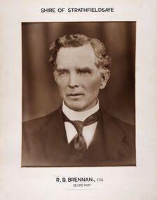
Photograph - Portrait of Shire Secretary Brennan, Unknown
The district of Strathfieldsaye was proclaimed in 1861 and named a Shire on the 17th September in 1866. It remained a shire until amalgamation in 1994 when it became part of the City of Greater Bendigo. The Shire was located 8 km to the south- east of Bendigo and covered an area of 601 square kilometres and extended from the Calder Highway to the Coliban and Campaspe Rivers. The shire's administration centre was in Strathfieldsaye until 1972 when new offices were opened in Kennington. Secretary Brennan, son of Councillor M. Brennan was appointed after his fathers death to the role and according to the The Bendigo Independent was in the role in 1917. See References.Framed black and white head and shoulder portrait of Councillor Brennan. Profile slightly to left. Cut rectangle cream mount. Hand written title top and lower centre. Shire of Strathfieldsaye / R. B. Brennan, Esq / Secretarystrathfieldsaye shire council, secretary strathfieldsaye shire -
 City of Greater Bendigo - Civic Collection
Photograph - Portrait of Councillor Hargraves, Bartlett Bros
The district of Strathfieldsaye was proclaimed in 1861 and named a Shire on the 17th September in 1866. It remained a shire until amalgamation in 1994 when it became part of the City of Greater Bendigo. The shire was located 8 km to the south- east of Bendigo and covered an area of 601 square kilometres and extended from the Calder Highway to the Coliban and Campaspe Rivers. The shire's administration centre was in Strathfieldsaye until 1972 when new offices were opened in KenningtonFramed black and white head and shoulder portrait of Councillor Hargraves. Profile slightly to right with walrus moustache. Cut rectangle brown mount decorated with coloured text and scrolls. Hand written title top and lower centre.Strathfiledsaye Shire Council / Cr John Hargreaves / President 1919 - 20 1928 - 29 / Presented by his Wife & Familystrathfieldsaye shire council, president of strathfieldsaye shire, councillor hargreaves -
 City of Greater Bendigo - Civic Collection
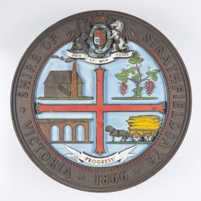
Sign - Shire of Strathfieldsaye Coat of Arms
The district of Strathfieldsaye was proclaimed in 1861 and named a Shire on the 17th September in 1866. It remained a shire until amalgamation in 1994 when it became part of the City of Greater Bendigo. The shire was located 8 km to the south- east of Bendigo and covered an area of 601 square kilometres and extended from the Calder Highway to the Coliban and Campaspe Rivers. The shire's administration centre was in Strathfieldsaye until 1972 when new offices were opened in Kennington. This coat of arms was commissioned for the front of the shire hall building.Brass painted coat of arms or emblem within a circle of the Shire of Strathfieldsaye. Outer rim contains text: SHIRE OF STRATHFIELDSAYE VICTORIA 1866 with the shield of the monarch of the United Kingdom centre top. The shield is divided into four parts with images reflecting the leading industries of the time; wine growing, mining, farming and tanning. The motto PROGRESS is depicted lower centre of shield. SHIRE OF STRATHFIELDSAYE / VICTORIA / 1866 / PROGRESSshire of strathfieldsaye, city of greater bendigo amalgamation, city of greater bendigo signs -
 City of Greater Bendigo - Civic Collection
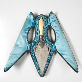
Ceremonial object - Engraved Silver Trowel, Bendigo and Eaglehawk Electric Light and Tramway Powerhouse, 1901
This trowel was presented to City of Bendigo Mayor, Simeon Ryan by Mr B. Deakin the Australian representative of the Victorian Electric Supply Company on the occasion of the laying of the foundation stone for the new power house building in Hargreaves Street, Bendigo. This power house was built to supply power to both Bendigo and Eaglehawk and the overhead power system for the tramway which ran from Quarry Hill, through the city to Eaglehawk and from Golden Square to Lake Weeroona. The building of the power house changed Eaglehawk and Bendigo as street lights were installed and houses became electrified. A report in the Bendigo Independent in 1902 reported ' Night will then be almost as brilliant as the day and people .... who live in the suburbs are to be provided with a tram service worth of the name'. (See reference A Mammoth Scheme.) The tramways closed in April 1972 after the Victorian Parliament granted the SEC an application to cease operating. Today Bendigo Trust operates the tourist trams which run along Pall Mall and welcomes over 40,000 visitors annually. The Bendigo Tramways Depot is the oldest operating tram depot in Australia and is listed on the Victorian Heritage Register. There are currently 45 trams in the fleet (13 of which operate as part of the 'Talking' Tram service).For more about the history and to tour the tramways visit www.bendigotramways.com.Triangular shaped silver engraved trowel with ivory handle (0286a). Top face of trowel is ornately engraved with floral and decorative motifs and an image of an electric tram and two power poles. Reverse has engraved text. No makers mark detected. Housed in a leather covered case (0286b), lined with ruched blue silk. Case has two brass hinges and two small brass clasps.PRESENTED / By / THE ELECTRIC SUPPLY CO / OF VICTORIA TO / SIMEON RYAN. ESQ JP. / MAYOR OF BENDIGO / ON THE OCCASION OF HIS LAYING / THE MEMORIAL STONE OF THE / BENDIGO AND EAGLEHAWK / ELECTRIC LIGHT AND TRAMWAY / POWER HOUSE / 26th JUNE, 1901/ STERLING SILVERcouncillor simeon ryan, councillor s h mc gowan, councillor john hoskins, councillor george loudon, councillor john green, councillor alfred hicks, borough of eaglehawk, borough of eaglehawk mayor, mayor loudon, city of bendigo mayor, mayor ryan, bendigo and eaglehawk tramway -
 City of Greater Bendigo - Civic Collection
Ceremonial object - Eaglehawk Bell, unknown
The Borough of Eaglehawk was a local government area which covered the northwestern suburbs of the regional city of Bendigo and covered an area of 14.54 square kilometres (5.6 sq mi). Eaglehawk was first incorporated as a borough on 29 July 1862. It had nine councillors, who represented the entire borough. Councillors met at the Town Hall (incorporating the Star Cinema) at the intersection of Sailors Gully Road and Loddon Valley Highway, Eaglehawk. The Town hall has always been the centre of the Borough's activities and was built in 1901 on the site of an earlier town hall which had stood on the location since 1865. The Victorian Heritage Database notes: "The present building replaced this earlier building and was opened on 14 August 1901. The architects were the Melbourne firm of Wilkinson and Permewan. As a much larger and more sumptuous building of brick and stone featuring a central clock tower, the new hall reflected prevailing architectural fashion and was a remarkable investment for a town consisting predominantly of poor mining families. The condition of the town hall is substantially as built. The design is almost identical to the Castlemaine Town Hall." On 7 April 1994, the Borough of Eaglehawk was abolished, and along with the City of Bendigo, the Rural City of Marong and the Shires of Huntly and Strathfieldsaye, was merged into the newly created City of Greater Bendigo.Brass bell with eaglehawk topper / handle on timber stand. The lower front section of the topper has the Borough of Eaglehawk seal attached. No hallmarks or makers stamps visible.borough of eaglehawk, star cinema -
 City of Greater Bendigo - Civic Collection
Newspaper, Shire of Marong, Upfront, c 1989
Marong was first incorporated as a road district on 27 August 1861, and became a shire on 23 December 1864. On 1 October 1915, the Borough of Raywood, which was gazetted on 17 January 1865 on 23.31 square kilometres of land 28 kilometres north of Bendigo was united with Marong. On 1 October 1990, the Shire of Marong became a rural city, under the Local Government Act 1989. In a report on 17 February 1994, the Local Government Board recommended that the five councils in the Bendigo region merge to form a "super city", with a population of about 81,000. Marong, Eaglehawk and Huntly had earlier objected to the proposal, and the Board noted a weak no vote against the merger proposal in a referendum in the region; about 70% had voted against, but with a turnout of between 30% and 40% of eligible voters. The three councils filed a writ in the Supreme Court, alleging failure to follow process by the Minister for Local Government, Roger Hallam, but by the time the new "super city" was announced, the writ had not yet been heard, and on 24 March 1994, the Rural City of Marong successfully applied for an injunction blocking the publication of the gazette the following day abolishing the five councils and appointing three commissioners. The government responded by introducing legislation, the City of Greater Bendigo Bill 1994, to Parliament, to effectively override the Supreme Court action, with Hallam saying "the bill would make clear that the Government is determined to achieve its objective for a more efficient municipal structure for the Bendigo region." Marong mayor Robert Hynes described the action as "terribly disappointing", adding, "One way or another, I believe it does mean an end to our fight... it seems the Government are above the law to me." On 6 April 1994, Marong voted to drop the Supreme Court action, effectively in doing so voting itself out of existence, and on 7 April 1994, the Rural City of Marong was abolished, and along with the City of Bendigo, the Borough of Eaglehawk and the Shires of Huntly and Strathfieldsaye, was merged into the newly created City of Greater Bendigo. On 29 April 1994, the Minister confirmed the Bill was not being proceeded with. https://en.wikipedia.org/wiki/Rural_City_of_MarongEight page newspaper style council newsletter providing community updates, news and information. shire of marong, city of greater bendigo amalgamation, councillor phillip eddy, rural city of marong -
 Melton City Libraries
Map, Streets of Melton, 1963
MELTON’S STREETS Heritage Week 2014 What’s in a Name? Alphabetical List Aboriginal place names, Early Family Names and landowners, Agricultural, Shop and Commercial premises, Places and Events Melton & District Historical Society Street Naming Project 1972 – c 1998 Suburb Name – KURUNJANG - Kirkton, 1972, Brookfield, West, 1988 Melton and Town Centre - A joint collaboration with the Shire of Melton and Subdivision Developers ARNOLD Court – Family house - Arnolds Creek ALKEMADE Drive Family – Lime kilns Coimadia ALEXANDRA Street 1902 – Corination of King Edward VII and Queen Alexandra AVIATOR Place Event, location of plane crash – Jimmy Melrose 1936 Adina ?Annibee - Anniba? Agricultural Avon court .. .. BAKERY Square - Location of Jongebloed shop, bakehouse and stables BALUK Place Aboriginal BARLEYCORN Place Agricultural BILLING Place Name of Jimmy Melrose Uncle Noel Pemberton Billing BLACKWOOD Drive - Alexander Blackwood 1860c Registrar BARRIES Road C. E. Barrie “Darlingsford” farmer 1911, chaff mill owner BROOKLYN Road Staughton family residence. 1875 – Dismantled c 193? CAHILL Drive Family - Glenville Dairy CAMERON Court Family Canopus Place ? CANALLAN Drive Early Surveyor CAMPBELL Court Aviation – Melrose passenger 6th July 1936 CARBERRY Drive Michael, early landowner family CAREW Court Edward and Michael. Royal Hotel. Vera (Carew) Forran Singer - Opera CASEY Court Family CASHIN Court Family CHEVIOT Court Agriculture, breed of sheep CHESNEY Road was re named ( Minns Road being duplicated c 1973) CHRISTINA Crescent Christina McPherson, daughter of James and Mary Mary McPherson. Died 1955 aged 85 years COLLYER Close a deleted street (parallel to Yuille) re-used CORRIEDALE Road Breed of sheep CORR Court Teacher at first school, landowner CROXTON Court Name of the Hornbuckle and Knox family home DALEY Court - William Daley and family 1865 Bootmaker High Street DARLINGSFORD Boulevard - Name of early homestead Thomas B Darling 1853 DJERRIWARRH Court - Parish County of Bourke - very early map. DODEMAIDE Place Early land owners - Melton Football Team had 6 brothers playing c 1924 DONALD Court McPherson family 6 generations in Melton in 1936 DOUGAL Court DUNCAN Court .. .. DUNVEGAN Circuit Home of the McPherson family, castle Isle of Skye Name of bluestone house Smith Street (now at Willows) EMIL Court Jongebloed family EXELL Avenue Farming family Melton Sth- Closer Settlement 1907 EXFORD Road Exe former name of the Werribee river FARMER Court Name of early postmistress FERRIS Road John Ferris Farmer HANNAH Close First name of Hannah Watts – midwife HAYBALE Place Agricultural HELDER Court Early surveyor J Helder Wedge map HEWSON Street Winston Hewson Shire Engineer – check title c 1960 HENRY Street Township map c 1860 HESTON Street Heston Phoenix – C.J. Melrose plane HILDEGARDE Court Jimmy Melrose’s mothers name HOMESTEAD Close HORNBUCKLE Cres Farmers. Three members of family - Shire Presidents HURLEY Street Farmers IAIN Court Descendent of James and Mary McPherson JAMES MELROSE Drive Name appears on 2013 Melton information map JANG Place KURUN – jang KIRKTON Drive Name of the McPherson family home Toolern Vale Road KIRWIN Street Michael early landowners (deleted for freeway construction) KILPATRICKS Road Deleted when Barries Road was extended across Station Rd KOROROIT Court Early map, Parish of Kororoit. Creek name KNOX Circuit Family – Hornbuckle “Croxton Park” KURRUNJANG Drive Aboriginal name for people of the red earth – Suburb name Lara Place ? LLOYD Court Garage owners High Street. Laura lived to 100 years D 1955 LUBY Court John Luby – Crown Grant Land Title LITTLE Court MANNING Avenue Richard, hotel owner 1891 MARGARET Drive McPherson family McDONALD Street Melton South family name McKENZIE Street Township c1860 MORROW Street Early name MOWBRAY Crescent Name of English Melton, popularly believed origin of Melton MYERS Court Early setters c 1866 Crown Grant Land Title NIMMO Street Early name NIXON Street Name submitted by Mary nee Nixon Collins c1985 OLDERSHAW Road Early builder PALMERSTON Street Early township map c 1860 PEART Court Early name PENNYROYAL Avenue Plant growing by the creek. Early name used for the Toolern Toolam Creek PINKERTON Street Family name and early street map PINNACLE Crescent Agricultural - type of wheat PHOENIX Circuit C.J. Melrose Phoenix Heston Plane 2013 map PRATT Family PRIOR Court PYKE Place Brothers – early settlement 1838 RADFORD Court Land owners and business operators. Former Royal Hotel Grocer High Street demolished 1970 RAGLAN Court Hotel 19th century Lord Raglan RALEIGHS Road Oliver Reierson family (Norweigen) Shopkeeper – Dressmakers RIDDELL Drive (misspelt Riddle) Resident and land owner RODERICK Road McPherson family – a re occurring name ROLLAND Court Jones family ROSS Court Daniel. Landowner. Agnes Ross music teacher RUSSELL Court Robert. Early land surveyor of Melton 1853 RYAN Court Family early landowner. Member of the 1862 Road Board SHEBLER Place Augustus early Melton resident – Golden Fleece Hotel SHEEPFOLD Court Farming SHERWIN Court Sherwin Street earliest Township map– became Golf course SMITH Street Early township map. STRATHULLOH Circuit Strathtulloh Homestead. STAUGHTON Street Family – LARGE land owners Strachan ? SWANEY Court Marie Swaney earlier resident of Strathtulloh. SUTHERLAND Family name TOOLERN Street TOOLAM – TOOLERN Creek TULLIDGE St Road marked on 1861 map UNITT Street Early Township c 1860 WALLACE Square Cr Jack Wallace 5 terms as President 46 years unopposed WATTS Court Hannah Watts – midwife, cottage hospital WALSINGHAM Name of house of Minns family. From Walsingham Norfolk England WESTLEY Place Name of Jimmy Melrose Percival Gull Plane WESTLAKE Drive Early resident WHICKHAM Street Family Name Melton South WILSON Road Albert, Melton South YUILLE Street William Cross, early landowner, Rockbank run Zoomed in section of Melton Streets including Church and High Streetlandscapes of significance