Showing 433 items
matching trams - kew
-
 Kew Historical Society Inc
Newspaper - Newspaper Article, Late Sir Henry Kellett, 1924, 1924
Sir Henry de Castres Kellett (1851-1924) the son of a hereditary baronet, was born at Mt Gambier, South Australia in 1851. His English title had been created in Ireland in 1801, but the family was originally Norman with the later branches living in England and Ireland. Sir Henry Kellett assumed the title in 1906. Henry Kellett was a prominent Kew retailer, continuing his father’s newspaper and stationery business in Bulleen Road (now High Street). At various stages, he also acted as an insurance, postal and real estate agent. He lived in Walpole Street and later at Lota Begg (now demolished) in Westbrook Street, East Kew. In 1884, Henry Kellett was elected to the Kew Borough Council and served for 40 years; a remarkable example of public service. He was elected Mayor for a single term in 1888-9. Sir Henry de Castres Kellett died in St George’s Hospital in 1924 following a tragic car accident in Cotham Road, Kew while on Council business. The vehicle, in which he was travelling with fellow councillors and the Town Clerk, collided with a tram. Sir Henry Kellett is commemorated in the naming of Kellett Reserve and Kellett Grove.Newspaper report from 1924, providing an obituary of Sir Henry de Castres Kellettmayors of kew (vic), sir henry de castres kellett -
 Kew Historical Society Inc
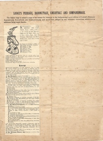
Document, Lodge's Peerage, Baronetage, Knightage and Companionage - KELLETT, Sir Henry de Castres Bart
Sir Henry de Castres Kellett (1851-1924) the son of a hereditary baronet, was born at Mt Gambier, South Australia in 1851. His English title had been created in Ireland in 1801, but the family was originally Norman with the later branches living in England and Ireland. Sir Henry Kellett assumed the title in 1906. Henry Kellett was a prominent Kew retailer, continuing his father’s newspaper and stationery business in Bulleen Road (now High Street). At various stages, he also acted as an insurance, postal and real estate agent. He lived in Walpole Street and later at Lota Begg (now demolished) in Westbrook Street, East Kew. In 1884, Henry Kellett was elected to the Kew Borough Council and served for 40 years; a remarkable example of public service. He was elected Mayor for a single term in 1888-9. Sir Henry de Castres Kellett died in St George’s Hospital in 1924 following a tragic car accident in Cotham Road, Kew while on Council business. The vehicle, in which he was travelling with fellow councillors and the Town Clerk, collided with a tram. Sir Henry Kellett is commemorated in the naming of Kellett Reserve and Kellett Grove.Printed extract from Lodge's Peerage, Baronetage, Knightage and Companionage listing KELLETT, Sir Henry de Castres Bart.mayors of kew (vic), sir henry de castres kellett -
 Kew Historical Society Inc
Photograph - Carte de Visite, Captain RJ Napier Kellett, Undated
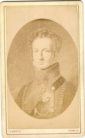
Sir Henry de Castres Kellett (1851-1924) the son of a hereditary baronet, was born at Mt Gambier, South Australia in 1851. His English title had been created in Ireland in 1801, but the family was originally Norman with the later branches living in England and Ireland. Sir Henry Kellett assumed the title in 1906. Henry Kellett was a prominent Kew retailer, continuing his father’s newspaper and stationery business in Bulleen Road (now High Street). At various stages, he also acted as an insurance, postal and real estate agent. He lived in Walpole Street and later at Lota Begg (now demolished) in Westbrook Street, East Kew. In 1884, Henry Kellett was elected to the Kew Borough Council and served for 40 years; a remarkable example of public service. He was elected Mayor for a single term in 1888-9. Sir Henry de Castres Kellett died in St George’s Hospital in 1924 following a tragic car accident in Cotham Road, Kew while on Council business. The vehicle, in which he was travelling with fellow councillors and the Town Clerk, collided with a tram. Sir Henry Kellett is commemorated in the naming of Kellett Reserve and Kellett Grove.Rare portrait of a Kellett ancestorCarte de Visite of Captain RJ Napier Kellett, an ancestor of Sir Henry de Castres Kellett.CAPN RK NAPIER KELLETT / RIFLE BRIGADE / WATERLOO MEDAL / CAPN ROYAL 42ND HIGHLANDERS THOS NORTH PHOTOGRAPHER / 71 GRAFTON STREET DUBLIN sir henry de castres kellett, cape rj napier kellett, battle of waterloo -
 Kew Historical Society Inc
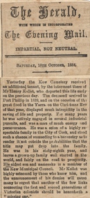
Newspaper - Newspaper Article, Sir Henry de Castres Kellett - Burial Report, 1924
Sir Henry de Castres Kellett (1851-1924) the son of a hereditary baronet, was born at Mt Gambier, South Australia in 1851. His English title had been created in Ireland in 1801, but the family was originally Norman with the later branches living in England and Ireland. Sir Henry Kellett assumed the title in 1906. Henry Kellett was a prominent Kew retailer, continuing his father’s newspaper and stationery business in Bulleen Road (now High Street). At various stages, he also acted as an insurance, postal and real estate agent. He lived in Walpole Street and later at Lota Begg (now demolished) in Westbrook Street, East Kew. In 1884, Henry Kellett was elected to the Kew Borough Council and served for 40 years; a remarkable example of public service. He was elected Mayor for a single term in 1888-9. Sir Henry de Castres Kellett died in St George’s Hospital in 1924 following a tragic car accident in Cotham Road, Kew while on Council business. The vehicle, in which he was travelling with fellow councillors and the Town Clerk, collided with a tram. Sir Henry Kellett is commemorated in the naming of Kellett Reserve and Kellett Grove.Newspaper report from 1924 of the funeral of Sir Henry de Castres Kellett at Boroondara General Cemeterysir henry de castres kellett -
 Kew Historical Society Inc
Newspaper - Newspaper Article, The Kellett Baronetcy, 1906, 1906
Sir Henry de Castres Kellett (1851-1924) the son of a hereditary baronet, was born at Mt Gambier, South Australia in 1851. His English title had been created in Ireland in 1801, but the family was originally Norman with the later branches living in England and Ireland. Sir Henry Kellett assumed the title in 1906. Henry Kellett was a prominent Kew retailer, continuing his father’s newspaper and stationery business in Bulleen Road (now High Street). At various stages, he also acted as an insurance, postal and real estate agent. He lived in Walpole Street and later at Lota Begg (now demolished) in Westbrook Street, East Kew. In 1884, Henry Kellett was elected to the Kew Borough Council and served for 40 years; a remarkable example of public service. He was elected Mayor for a single term in 1888-9. Sir Henry de Castres Kellett died in St George’s Hospital in 1924 following a tragic car accident in Cotham Road, Kew while on Council business. The vehicle, in which he was travelling with fellow councillors and the Town Clerk, collided with a tram. Sir Henry Kellett is commemorated in the naming of Kellett Reserve and Kellett Grove.Letter to the Editor by Sir Henry de Castres Kellett regarding his Baronetcysir henry de castres kellett, kellett baronetcy -
 Kew Historical Society Inc
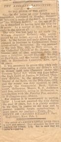
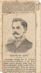
Newspaper - Newspaper Article, Cr Henry Kellett, Mayor of Kew, 1888
Sir Henry de Castres Kellett (1851-1924) the son of a hereditary baronet, was born at Mt Gambier, South Australia in 1851. His English title had been created in Ireland in 1801, but the family was originally Norman with the later branches living in England and Ireland. Sir Henry Kellett assumed the title in 1906. Henry Kellett was a prominent Kew retailer, continuing his father’s newspaper and stationery business in Bulleen Road (now High Street). At various stages, he also acted as an insurance, postal and real estate agent. He lived in Walpole Street and later at Lota Begg (now demolished) in Westbrook Street, East Kew. In 1884, Henry Kellett was elected to the Kew Borough Council and served for 40 years; a remarkable example of public service. He was elected Mayor for a single term in 1888-9. Sir Henry de Castres Kellett died in St George’s Hospital in 1924 following a tragic car accident in Cotham Road, Kew while on Council business. The vehicle, in which he was travelling with fellow councillors and the Town Clerk, collided with a tram. Sir Henry Kellett is commemorated in the naming of Kellett Reserve and Kellett Grove.Illustrated newspaper article from 1888, describing the elevation to the position of mayor of Kew by Cr Henry KellettHERALD 29/8/88sir henry de castres kellett, mayors of kew -
 Kew Historical Society Inc
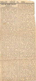
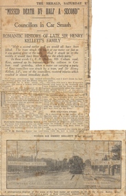
Newspaper - Newspaper Article, Missed Death by Half a Second - Councillors in Car Smash, 1924, 1924
Sir Henry de Castres Kellett (1851-1924) the son of a hereditary baronet, was born at Mt Gambier, South Australia in 1851. His English title had been created in Ireland in 1801, but the family was originally Norman with the later branches living in England and Ireland. Sir Henry Kellett assumed the title in 1906. Henry Kellett was a prominent Kew retailer, continuing his father’s newspaper and stationery business in Bulleen Road (now High Street). At various stages, he also acted as an insurance, postal and real estate agent. He lived in Walpole Street and later at Lota Begg (now demolished) in Westbrook Street, East Kew. In 1884, Henry Kellett was elected to the Kew Borough Council and served for 40 years; a remarkable example of public service. He was elected Mayor for a single term in 1888-9. Sir Henry de Castres Kellett died in St George’s Hospital in 1924 following a tragic car accident in Cotham Road, Kew while on Council business. The vehicle, in which he was travelling with fellow councillors and the Town Clerk, collided with a tram. Sir Henry Kellett is commemorated in the naming of Kellett Reserve and Kellett Grove.Illustrated newspaper article from 1924, describing the death of Cr Henry Kellettsir henry de castres kellett -
 Kew Historical Society Inc
Photograph, J F C Farquhar, The Post Office, 1891
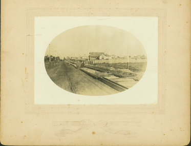
... was erected by the Kew Borough Council to commemorate the Golden... for the Kew War Memorial. The tram tracks in High Street were used ...At the beginning of the 1890s, the Kew businessman and Town Councillor, Henry Kellett, commissioned J.F.C. Farquhar to photograph scenes of Kew. These scenes included panoramas as well as pastoral scenes. The resulting set of twelve photographs was assembled in an album, Kew Where We Live, from which customers could select images for purchase.The preamble to the album describes that the photographs used the ‘argentic bromide’ process, now more commonly known as the gelatine silver process. This form of dry plate photography allowed for the negatives to be kept for weeks before processing, hence its value in landscape photography. The resulting images were considered to be finely grained and everlasting. Evidence of the success of Henry Kellett’s venture can be seen today, in that some of the photographs are held in national collections.It is believed that the Kew Historical Society’s copy of the Kellett album is unique and that the photographs in the book were the first copies taken from the original plates. It is the first and most important series of images produced about Kew. The individual images have proved essential in identifying buildings and places of heritage value in the district.A panoramic photograph of the junction of High Street and Cotham Road. The photographer centres the point-of-view on the Kew Post Office and adjacent Court House. These were designed in the Queen Anne style by the Public Works Department's architect J Harvey and completed in 1888. The complex is important because it demonstrates a departure from the contemporaneously favoured High Victorian Classical to the Queen Anne style in the design of civic buildings. The earlier Jubilee Fountain in front of the Post Office was erected by the Kew Borough Council to commemorate the Golden Jubilee of Queen Victoria in 1887. It was created to a design of the architects Reed, Henderson and Smart. The fountain was later relocated to the Alexandra Gardens to make way for the Kew War Memorial. The tram tracks in High Street were used by the horse tram, which ran from the Victoria Street Bridge to the Boroondara General Cemetery. The tram was replaced by an electrified service in 1915.The Post Officekew post office, kew illustrated, kew where we live, photographic books, henry kellett -
 Kew Historical Society Inc
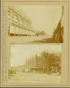
Photograph, J F C Farquhar, High Street, Kew, 1891
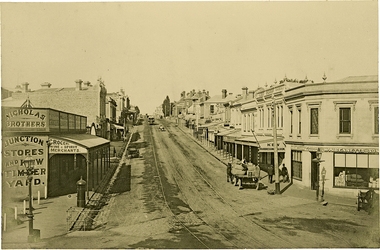
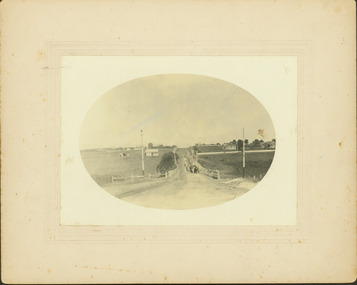
At the beginning of the 1890s, the Kew businessman and Town Councillor, Henry Kellett, commissioned J.F.C. Farquhar to photograph scenes of Kew. These scenes included panoramas as well as pastoral scenes. The resulting set of twelve photographs was assembled in an album, Kew Where We Live, from which customers could select images for purchase.The preamble to the album describes that the photographs used the ‘argentic bromide’ process, now more commonly known as the gelatine silver process. This form of dry plate photography allowed for the negatives to be kept for weeks before processing, hence its value in landscape photography. The resulting images were considered to be finely grained and everlasting. Evidence of the success of Henry Kellett’s venture can be seen today, in that some of the photographs are held in national collections.It is believed that the Kew Historical Society’s copy of the Kellett album is unique and that the photographs in the book were the first copies taken from the original plates. It is the first and most important series of images produced about Kew. The individual images have proved essential in identifying buildings and places of heritage value in the district.In 1891, High Street was the centre of commercial activity in the Borough of Kew. It was unpaved and edged with deep bluestone gutters, which were designed to channel the significant flow of storm water down the hill to and beyond the Junction. On either side of the entrance to the shopping strip are two cast iron gas lamps that provided the only public street lighting before the Post Office was reached. Most shops, including the Nicholas Brothers’ Junction Store featured cast iron verandas. Further up the hill, Dougherty’s Greyhound Hotel was by this stage a local institution. Apart from the horse-drawn tram, the main form of personal and commercial transport in this period remained the horse, horse and cart, or buggy.The panoramic view predates the widening of High Street in the 20th century, and thus includes the original alignment of buildings on the south side. These included Henry Kellett’s shop.High Street, Kewkew illustrated, kew where we live, photographic books, henry kellett, high street - kew (vic) -
 Kew Historical Society Inc
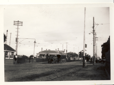
Photograph, Corner of Cotham and Burke Roads, Kew, 1919
... burke road (kew cotham road (kew) deepdene trams NEAR COTHAM ...Black and white photograph of the corner of Cotham and Burke Roads in Kew. The house at centre is 'Deepdene'. Public and private transport is represented by the two horses pulling a carriage into Whitehorse Road and the tram at the terminus. The photograph is one of two of the vista gifted by the Bennett family in 1980.NEAR COTHAM ROAD CNR / HORSE TRANSPORT 1890s? / GIFT FROM BENNETT FAMILYburke road (kew, cotham road (kew), deepdene, trams -
 Kew Historical Society Inc
Photograph, Corner of Cotham and Burke Roads, Kew, 1919
... burke road (kew cotham road (kew) deepdene trams 1919 BURKE ...Black and white photograph of the corner of Cotham and Burke Roads in Kew. The house at centre is 'Deepdene'. Public and private transport is represented by the two horses pulling a carriage into Whitehorse Road and the tram at the terminus. The photograph is one of two of the vista gifted by the Bennett family in 1980.1919 BURKE AND WHITEHORSE RDS CORNER / GIFT BENNETT FAMILY. REG NO KH-408burke road (kew, cotham road (kew), deepdene, trams -
 Kew Historical Society Inc
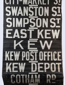
Functional object - Destination Roll, Melbourne & Metropolitan Tramways Board, 1960s
In an era predating the computerisation of equipment on public transport, where trams in Melbourne were driven by drivers and conductors sold fares, destinations were shown at the front and rear of the tram within a glazed box. A driver adjusted the roll to select each new trip destination. Given the length of rolls, in this case approximately nine metres, this could be a time consuming process. In addition to the named destination roll, each tram included a separate roll listing the route numbers.The roll was purchased at a Leski Auction in Armadale as part of a large group of tramways memorabilia including tram 'rolls' from New South Wales, Victoria, South Australia and Tasmania. The auction house described the collection as "The collection of destination blinds or rolls that forms the core of the Railways Trams & Buses Section (Lots 655 – 732) is the best we have ever offered and represents a life-time of collecting by an Adelaide enthusiast, now deceased." Melbourne & Metropolitan Tramways Board Tramways Destination Roll. Black and white paint on linen roll. Forty-eight named destinations including four depots - Camberwell, Hanna Street, Hawthorn, Kew. Multiple destinations in what is now the City of Boroondara (Kew, Hawthorn and Camberwell); including East Kew, Kew, Kew Post Office, Kew Depot, and Cotham Road.Named destinations beginning to end: “Olympic Park / Special / Football / Racecourse / Richmond / Burnley / Riversdale / Wattle Park - Warragul Rd / Wattle Park - Elgar Rd / City / Burwood / Hartwell / Bowen St / Camberwell Depot / Camberwell Jucn / Leura Grove / Gardener / Glenferrie Rd / Chapel St / St Kilda Rd / Camberwell / City / Lonsdale St / University / City via William St / Domain Rd / Hanna St Depot / South Melb & St Kilda Beach / Prahran / North Richmond / Windsor / Hawthorn Depot / Hawthorn / Spencer St / Toorak Rd / Swan & Church St Cnr / North Balwyn / City Flinders & Spencer Sts Corner / City - Market St / Swanston St / Simpson St / East Kew / Kew / Kew Post Office / Kew Depot / Cotham Rd / Malv Tn Hall"melbourne & metropolitan tramways board -
![Entrance to Boroondara General [Kew] Cemetery](/media/collectors/550653872162f11fb04854aa/items/63682b04f92fc2bf8e439f85/item-media/63682be2f92fc2bf8e43a57d/item-fit-380x285.jpg) Kew Historical Society Inc
Kew Historical Society IncPhotograph - Entrance to Boroondara General [Kew] Cemetery, 1979
Original black and white print positive photograph of buildings, including the clock tower, and entrance to the Boroondara General Cemetery in Kew.The photograph, by Nita Green [of Reno] is taken from High Street and shows the northwest corner of the High brick wall surrounding the complex. There is a tram shelter at left and a woman standing beside a light pole.Reverse: "Donated by Nita Green 1979 / Entrance to Boroondara Cemetery"boroondara general cemetery, cemeteries - kew (vic.), nita green -
 Kew Historical Society Inc
Journal, Kewriosity : November 1991
... community newsletters The Horse Tram returns to Kew [Kew Depot Open ...The Horse Tram returns to Kew [Kew Depot Open Day] / p1. Chief Executive's Comment [Kew Junction] / Malcolm Hutchinson p2. Mayor's Comment [Kew Junction Strategy Plan] / Cr Daryl Oldaker p3. Diary Dates for November / p4. Diary Dates for December / p5. The Lioness Club of Kew / p5. Market [Kew Community House] / p5. Invitation to Lawn Bowls [Auburn Heights Bowling Club] / p5. Leader Sports Challenge Camp / p6. New face [Heather Crichton] / p7. New Way Theatre [Company][Kew Cottages] / p7. Safe disposal of chemicals around the home [Disposal options - Waste type by location] / p8. Insects / Marlowe p9. Bothered by pests? [Improved and cheap pest control for Kew residents] / p9. Kewriosity advertising rates / p10. City of Kew Waste Disposal Services for 1991/92 / Malcolm Hutchinson p11. New mum presentation [Nursing Mothers' Association; St George's Hospital] / p12. Kew Auxiliary - Royal Women's Hospital / p12. L.Bear [Library Bear] / p13. Arthritis self help / p14. Mural [by Bill Wood] / p14. Old Trams [request for photos] / p14. Kew Info Youth / p15. Local Artist [Mary McQueen] / p15. Golden putter golf [Studley Park Golf Course] / p15. City of Kew Residential Policies Review Committee [update] / p16. Apology [Kew Community House program] / p16.Kewriosity was a local newsletter combining Kew Council and community news. It was published between November 1983 and June 1994, replacing an earlier Kewriosity [broad] Sheet (1979-84). In producing Kewriosity, Council aimed to provide a range of interesting and informative articles covering its deliberations and decision making, together with items of general interest and importance to the Kew community and information not generally available through daily media outlets.non-fictionThe Horse Tram returns to Kew [Kew Depot Open Day] / p1. Chief Executive's Comment [Kew Junction] / Malcolm Hutchinson p2. Mayor's Comment [Kew Junction Strategy Plan] / Cr Daryl Oldaker p3. Diary Dates for November / p4. Diary Dates for December / p5. The Lioness Club of Kew / p5. Market [Kew Community House] / p5. Invitation to Lawn Bowls [Auburn Heights Bowling Club] / p5. Leader Sports Challenge Camp / p6. New face [Heather Crichton] / p7. New Way Theatre [Company][Kew Cottages] / p7. Safe disposal of chemicals around the home [Disposal options - Waste type by location] / p8. Insects / Marlowe p9. Bothered by pests? [Improved and cheap pest control for Kew residents] / p9. Kewriosity advertising rates / p10. City of Kew Waste Disposal Services for 1991/92 / Malcolm Hutchinson p11. New mum presentation [Nursing Mothers' Association; St George's Hospital] / p12. Kew Auxiliary - Royal Women's Hospital / p12. L.Bear [Library Bear] / p13. Arthritis self help / p14. Mural [by Bill Wood] / p14. Old Trams [request for photos] / p14. Kew Info Youth / p15. Local Artist [Mary McQueen] / p15. Golden putter golf [Studley Park Golf Course] / p15. City of Kew Residential Policies Review Committee [update] / p16. Apology [Kew Community House program] / p16.publications -- city of kew (vic.), kewriosity, council newsletters, community newsletters -
Kew Historical Society Inc
Journal, Kewriosity : March 1991
Kew Festival 10th March to 24th March - Kew is for living / artwork Heike Effler / p1. Dates for March [1991] / p2. Easter hours [Council Offices] / 2. 10th April [Rates and dog registrations due] / p2. Voters' Roll / p2. [Kew] Community House events / p2. Commentary / Cr Daryl Oldaker p3. Council's casino letter [Willsmere] / p3. Later to the editor [Casino] / E Stanley Meyer p3. Information: your view [Council survey] / p2. Cotham Road rebuilt [reconstruction] / p4. Anybody home? [1991 Census] / p4. Valley views protected [development along the Yarra River] / p4. Reaching the tram [upgrades] / p5. Traffic management update [Area 4, Area 5, Area 6, Area 7, Area 10] / p5. 7,000 more Kewites [projected population growth] / p5. New school buildings [Ruyton Girls' School; Methodist Ladies' College; Trinity Grammar; Xavier College; Genazzano College; Carey Grammar School; Preshil] / p5. High St [Pedestrian] Crossing / p5. St George's amalgamated [with Victoria Parade Geriatric Centre, Henry Pride Unit, Hawthorn Day Hospital] / p6. Youth co-ordination [Youth Workers' Forum] / p6. Bowling vacancies [East Kew Bowling Club] / p6. Driver wanted [for Henry Pride Geriatric Centre] / p6. On World's rooftop [Trinity Grammar students and teachers in Nepal] / p6. Trinity Day / p6. Clergy move / p6. Bus volunteers [needed for Kew Community Bus] / p6. Festival artist [Heike Effler] / p7. Citizens honoured [Australia Day honours] / p7. Medallion award [Royal Guide Dogs Association] / p7. Will bunny arrive? [Three and Fours Kindergarten] / p8. Fun with your children [Highbury Grove Playgroup] / p8. 2nd birthday celebrations [Kew Recreation Centre] / p8. Free electrolysis / p8. Empress of Britain [1938 voyage] / p8. Japanese woodblocks [exhibition at East West Art] / p8. Join the cast [Viola Musical Comedy Society]Kewriosity was a local newsletter combining Kew Council and community news. It was published between November 1983 and June 1994, replacing an earlier Kewriosity [broad] Sheet (1979-84). In producing Kewriosity, Council aimed to provide a range of interesting and informative articles covering its deliberations and decision making, together with items of general interest and importance to the Kew community and information not generally available through daily media outlets.non-fictionKew Festival 10th March to 24th March - Kew is for living / artwork Heike Effler / p1. Dates for March [1991] / p2. Easter hours [Council Offices] / 2. 10th April [Rates and dog registrations due] / p2. Voters' Roll / p2. [Kew] Community House events / p2. Commentary / Cr Daryl Oldaker p3. Council's casino letter [Willsmere] / p3. Later to the editor [Casino] / E Stanley Meyer p3. Information: your view [Council survey] / p2. Cotham Road rebuilt [reconstruction] / p4. Anybody home? [1991 Census] / p4. Valley views protected [development along the Yarra River] / p4. Reaching the tram [upgrades] / p5. Traffic management update [Area 4, Area 5, Area 6, Area 7, Area 10] / p5. 7,000 more Kewites [projected population growth] / p5. New school buildings [Ruyton Girls' School; Methodist Ladies' College; Trinity Grammar; Xavier College; Genazzano College; Carey Grammar School; Preshil] / p5. High St [Pedestrian] Crossing / p5. St George's amalgamated [with Victoria Parade Geriatric Centre, Henry Pride Unit, Hawthorn Day Hospital] / p6. Youth co-ordination [Youth Workers' Forum] / p6. Bowling vacancies [East Kew Bowling Club] / p6. Driver wanted [for Henry Pride Geriatric Centre] / p6. On World's rooftop [Trinity Grammar students and teachers in Nepal] / p6. Trinity Day / p6. Clergy move / p6. Bus volunteers [needed for Kew Community Bus] / p6. Festival artist [Heike Effler] / p7. Citizens honoured [Australia Day honours] / p7. Medallion award [Royal Guide Dogs Association] / p7. Will bunny arrive? [Three and Fours Kindergarten] / p8. Fun with your children [Highbury Grove Playgroup] / p8. 2nd birthday celebrations [Kew Recreation Centre] / p8. Free electrolysis / p8. Empress of Britain [1938 voyage] / p8. Japanese woodblocks [exhibition at East West Art] / p8. Join the cast [Viola Musical Comedy Society]publications -- city of kew (vic.), kewriosity, council newsletters, community newsletters -
Kew Historical Society Inc
Journal, Kewriosity : April 1989
Meals [on Wheels] well appreciated / p1 Report on East Kew "overdevelopment" / p1. Dates for April / p2. Commentary [civic awards, volunteers] / Cr Allen Martin / p3. Kew's nod to power line suggestion / p3. New Councillor [Cr Tom Indovino, Cr Joe Ormando, profiles] / p3. Cotham Road reconstructed [Streetscaping Master Plan] / p3. Traffic Management updates / p4. Ivy's number one [Ivy Smith, Kew Recreation Centre] / p4. In for a penny ... [dog pound] / p4. ... Bad times just around the corner [Kew City Library] / p4. Residents form action group [Cotham Residents’ Action Group] / p4. As Ruyton likes it ["As You Like It"] / p5. MLC fair sounds fun / p5. Students look for accommodation / p5. Asthma Swim classes here [Kew Recreation Centre] / p5. Watch your car [Neighbourhood Watch] / p6. Watch my lips [lip reading classes] / p6. Watch the birdie [Red Cross tour] / p6. Watch the meeting [Kew Community Action Group] / p6. Watch this space / p6. Playgroup binds young and old [Carnsworth-Garoopna Nursing Home] / p6. Baptist re-union / p6. School's 75th [The School for the Burwood Boys' Home, Wattle Park Primary School] / p6. What's the point in baby-sitting [Boroondara Babysitting Club] / p7. Heritage Week [Willsmere, Kew Historical Society] / p7. Bodalla Garden Party / p7. Youthful fitness [Little Athletics] / p7. Keeping you informed [Citizens Advice Bureau] / p8. Tram dream / p8. Hefty competition [weightlifting] / p8. [Kew Citizens'] Band competes at Ipswich / p8. Join the Chorus [Viola Musical Comedy Society ] / p8. Non-stop chamber music for Kew [Elysium Ensemble] / p8.Kewriosity was a local newsletter combining Kew Council and community news. It was published between November 1983 and June 1994, replacing an earlier Kewriosity [broad] Sheet (1979-84). In producing Kewriosity, Council aimed to provide a range of interesting and informative articles covering its deliberations and decision making, together with items of general interest and importance to the Kew community and information not generally available through daily media outlets.non-fictionMeals [on Wheels] well appreciated / p1 Report on East Kew "overdevelopment" / p1. Dates for April / p2. Commentary [civic awards, volunteers] / Cr Allen Martin / p3. Kew's nod to power line suggestion / p3. New Councillor [Cr Tom Indovino, Cr Joe Ormando, profiles] / p3. Cotham Road reconstructed [Streetscaping Master Plan] / p3. Traffic Management updates / p4. Ivy's number one [Ivy Smith, Kew Recreation Centre] / p4. In for a penny ... [dog pound] / p4. ... Bad times just around the corner [Kew City Library] / p4. Residents form action group [Cotham Residents’ Action Group] / p4. As Ruyton likes it ["As You Like It"] / p5. MLC fair sounds fun / p5. Students look for accommodation / p5. Asthma Swim classes here [Kew Recreation Centre] / p5. Watch your car [Neighbourhood Watch] / p6. Watch my lips [lip reading classes] / p6. Watch the birdie [Red Cross tour] / p6. Watch the meeting [Kew Community Action Group] / p6. Watch this space / p6. Playgroup binds young and old [Carnsworth-Garoopna Nursing Home] / p6. Baptist re-union / p6. School's 75th [The School for the Burwood Boys' Home, Wattle Park Primary School] / p6. What's the point in baby-sitting [Boroondara Babysitting Club] / p7. Heritage Week [Willsmere, Kew Historical Society] / p7. Bodalla Garden Party / p7. Youthful fitness [Little Athletics] / p7. Keeping you informed [Citizens Advice Bureau] / p8. Tram dream / p8. Hefty competition [weightlifting] / p8. [Kew Citizens'] Band competes at Ipswich / p8. Join the Chorus [Viola Musical Comedy Society ] / p8. Non-stop chamber music for Kew [Elysium Ensemble] / p8. publications -- city of kew (vic.), kewriosity, council newsletters, community newsletters -
Kew Historical Society Inc
Journal, Kewriosity : November 1985
Our window [Alan Sumner, The Four Seasons] / p1. Linear Park will not affect E6 [Outer Circle railway reserve] / p1&5. Dates for November / p2&8. [Community] Notices / p2. Update: Notes from Council - [Council] Budget Go-ahead / Cr Phyllis Hore [Mayor of Kew] / p3. Traffic management / p3. In Brief [Recycling transfer; Walmer Street Appeal quashed; Deregulation of shared housing; Review sought on full day care decision; Whither Willsmere?; Cable tram centenary exhibition; Election possible; Community Assistance Grants] / p4. Death of Councillor Murray Wood / p4. 40 years of home-help in Kew / p5. Three year old Kinder [Argyle Road; Davis Street] / p5. Youth Page - New publications for youth [Streetwise comics; Making unemployment work] / p6. How we passed our time - 2 [social history] / Bill Stent p7. A Group Apprenticeship Scheme for Eastern Suburbs / p7. Kew Community House / p8. Room for one more [student hosting] / p8. North Kew Tennis Club / p8. Kew Young Liberals / p8. Kew Band in concert / p8.Kewriosity was a local newsletter combining Kew Council and community news. It was published between November 1983 and June 1994, replacing an earlier Kewriosity [broad] Sheet (1979-84). In producing Kewriosity, Council aimed to provide a range of interesting and informative articles covering its deliberations and decision making, together with items of general interest and importance to the Kew community and information not generally available through daily media outlets.non-fictionOur window [Alan Sumner, The Four Seasons] / p1. Linear Park will not affect E6 [Outer Circle railway reserve] / p1&5. Dates for November / p2&8. [Community] Notices / p2. Update: Notes from Council - [Council] Budget Go-ahead / Cr Phyllis Hore [Mayor of Kew] / p3. Traffic management / p3. In Brief [Recycling transfer; Walmer Street Appeal quashed; Deregulation of shared housing; Review sought on full day care decision; Whither Willsmere?; Cable tram centenary exhibition; Election possible; Community Assistance Grants] / p4. Death of Councillor Murray Wood / p4. 40 years of home-help in Kew / p5. Three year old Kinder [Argyle Road; Davis Street] / p5. Youth Page - New publications for youth [Streetwise comics; Making unemployment work] / p6. How we passed our time - 2 [social history] / Bill Stent p7. A Group Apprenticeship Scheme for Eastern Suburbs / p7. Kew Community House / p8. Room for one more [student hosting] / p8. North Kew Tennis Club / p8. Kew Young Liberals / p8. Kew Band in concert / p8. publications -- city of kew (vic.), kewriosity, council newsletters, community newsletters -
Kew Historical Society Inc
Plan - Camberwell Panorama Estate, 1923
Subdivision plans and real estate flyers/brochures reveal a number of aspects of urban development and history. The Kew Historical Society's collection of these plans, as well as advertisements extracted from magazines, cover key aspects of community development and architectural history of Kew and Kew Eat as well as surrounding suburbs. While most of the plans in the collection were gifted to the Society by the former City of Kew, a number of other plans and advertisements have been donated by individuals, of which this is an example.Promotional brochure for the Camberwell Panorama Estate. The four page bifold handout advertises 216 home sites bounded by Bulleen Road, The Nook, Fortuna Avenue, and Doncaster Road. Other streets in the subdivision include: Sunburst Avenue, The Moor, and Macedon Avenue. The brochure has been damaged at some time in the past and so masking tape obscures the tram on page 1. Page 2 includes the plan of the subdivision, page 3 information about the site and a locality plan, while page 4 includes photographs and terms of sale. subdivision plans -- balwyn north (vic.), camberwell panorama estate -
 Kew Historical Society Inc
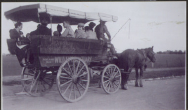
Photograph - Visit from Kew to Doncaster, 1914-18
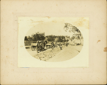
Members of the Milo family of horse-in a carriage travelling from Stawell Street Kew on a list to a violet farm in Doncaster."NAN TERRY W RAY FOX & JACK COGLIN GOING TO VIOLET FARM / DONCASTER / 'BUS' RAN FROM END OF TRAMLINE TO DONCASTER / MONT ALBERT TRAM / WILD LIFE SANCTUARYfamilies -- stawell street -- kew (vic.), milo family, violet farm -- doncaster -
 Kew Historical Society Inc
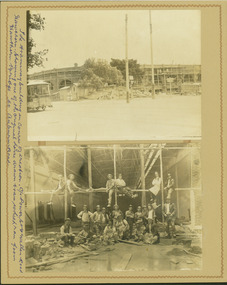
Photograph - Hawthorn Tram Depot during construction, 1915
One of a series of photographs, taken by Edgar James Dower in the second decade of the twentieth century. Born and raised in Olinda, his family later moved to Surrey Hills. He worked as an adult as a clerk in the city office of the Metropolitan Gas Company, and in his role as a 'collector', he was able to photograph scenes including the construction of tramlines and associated buildings in Kew, Hawthorn, Camberwell and Surrey Hills. Later he established a real estate agency with his brother - the E.J. Dower Real Estate Agency, Dandenong Office.The image is an historically significant record of the development of transport infrastructure which was used to connect Victorians in the first two decades of the twentieth century. This development resulted from increases in population and the consequent extension of Melbourne's suburbs. The photographs, both individually and collectively, richly detail the labour of workers and the tools and machinery used to create and extend Melbourne's tram network in the years preceding and during World War 1.Two faded original horizontal photographs, mounted on vertical card showing external and internal features of the Hawthorn Tram Depot during its construction phase. The top photo shows a panoramic view of the exterior while the second photo shows workers posed within the building.Recto: "The tramways building in course of creation. C/r of Power St & Wallen Road, Hawthorn. Showing one of the original horse drawn trams which ran from Hawthorn Bridge to Auburn Road".. theme --- travelling by tram, theme -- connecting victorians by transport and communications, tramways -- hawthorn -
 Kew Historical Society Inc
Photograph - Railway level crossing in Glenferrie Road, Glenferrie, E.J. Dower, 1912
Contextual or historic information One of a series of photographs, taken by Edgar James Dower in the second decade of the twentieth century. Born and raised in Olinda, his family later moved to Surrey Hills. He worked as an adult as a clerk in the city office of the Metropolitan Gas Company, and in his role as a 'collector', he was able to photograph scenes including the construction of tramlines and associated buildings in Kew, Hawthorn, Camberwell and Surrey Hills. Later he established a real estate agency with his brother - the E.J. Dower Real Estate Agency, Dandenong Office.The image is an historically significant record of the development of transport infrastructure which was used to connect Victorians in the first two decades of the twentieth century. This development resulted from increases in population and the consequent extension of Melbourne's suburbs. The photographs, both individually and collectively, richly detail the labour of workers and the tools and machinery used to create and extend Melbourne's tram network in the years preceding and during World War 1.Two faded original horizontal photographs, mounted on vertical card showing the original railway level crossing in Glenferrie Road, Hawthorn, before a railway overpass was constructed and the laying of the electric tramline. The two photos depict northern and southern views of the crossing. Dimensions: Photo 1 106 x 157 mm Photo 2 107 x 147 mm Mount 249 x 197 mmAnnotated recto: "Showing tramway gates at Glenferrie, taken 1912 by E.J. Dower, just prior to construction of electric tramline." Verso: "1912"theme --- travelling by tram, theme -- connecting victorians by transport and communications, trams -- boroondara (vic.), tramways -- hawthorn, trains -- hawthorn (vic.), glenferrie station -
![Electric tramway construction in Riversdale Road [Surrey Hills]](/media/collectors/550653872162f11fb04854aa/items/661deb37344c8682d4fa54e0/item-media/661dec13344c8682d4fa98bd/item-fit-380x285.jpg) Kew Historical Society Inc
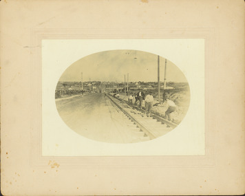
Kew Historical Society IncPhotograph - Electric tramway construction in Riversdale Road [Surrey Hills], E.J. Dower, 1916
Contextual or historic information One of a series of photographs, taken by Edgar James Dower in the second decade of the twentieth century. Born and raised in Olinda, his family later moved to Surrey Hills. He worked as an adult as a clerk in the city office of the Metropolitan Gas Company, and in his role as a 'collector', he was able to photograph scenes including the construction of tramlines and associated buildings in Kew, Hawthorn, Camberwell and Surrey Hills. Later he established a real estate agency with his brother - the E.J. Dower Real Estate Agency, Dandenong Office.The image is an historically significant record of the development of transport infrastructure which was used to connect Victorians in the first two decades of the twentieth century. This development resulted from increases in population and the consequent extension of Melbourne's suburbs. The photographs, both individually and collectively, richly detail the labour of workers and the tools and machinery used to create and extend Melbourne's tram network in the years preceding and during World War 1.Digital copy of an original mounted photograph of construction of the electric tramline in Riversdale Road, Surrey Hills.Annotated verso: "Showing the commencement of preparing for electric trams in Riversdale Road / Taken from the corner of Union Road, note Essex road on right with picket fencing"theme --- travelling by tram, theme -- connecting victorians by transport and communications, trams -- boroondara (vic.), tramlines -- surrey hills -
 Kew Historical Society Inc
Photograph - Removal of the horse tram line in Riversdale Road, Hawthorn, E.J. Dower, c.1916
One of a series of photographs, taken by Edgar James Dower in the second decade of the twentieth century. Born and raised in Olinda, his family later moved to Surrey Hills. He worked as an adult as a clerk in the city office of the Metropolitan Gas Company, and in his role as a 'collector', he was able to photograph scenes including the construction of tramlines and associated buildings in Kew, Hawthorn, Camberwell and Surrey Hills. Later he established a real estate agency with his brother - the E.J. Dower Real Estate Agency, Dandenong Office.The image is an historically significant record of the development of transport infrastructure which was used to connect Victorians in the first two decades of the twentieth century. This development resulted from increases in population and the consequent extension of Melbourne's suburbs. The photographs, both individually and collectively, richly detail the labour of workers and the tools and machinery used to create and extend Melbourne's tram network in the years preceding and during World War 1.Digital copy of an original mounted photograph of the removal of the horse tram tracks in Riversdale Road, Hawthorn, in preparation for laying the new electric tramline.Annotated verso: "Pulling up Hawthorn horse tram line in Riversdale Road, which ran from Hawthorn Bridge to Auburn Road"theme --- travelling by tram, theme -- connecting victorians by transport and communications, trams -- boroondara (vic.), horse tram -- hawthorn (vic.), riversdale road -
 Kew Historical Society Inc
Photograph - Construction of the electric tram line in Riversdale Road, Surrey Hills, E.J. Dower, 1916
One of a series of photographs, taken by Edgar James Dower in the second decade of the twentieth century. Born and raised in Olinda, his family later moved to Surrey Hills. He worked as an adult as a clerk in the city office of the Metropolitan Gas Company, and in his role as a 'collector', he was able to photograph scenes including the construction of tramlines and associated buildings in Kew, Hawthorn, Camberwell and Surrey Hills. Later he established a real estate agency with his brother - the E.J. Dower Real Estate Agency, Dandenong Office.The image is an historically significant record of the development of transport infrastructure which was used to connect Victorians in the first two decades of the twentieth century. This development resulted from increases in population and the consequent extension of Melbourne's suburbs. The photographs, both individually and collectively, richly detail the labour of workers and the tools and machinery used to create and extend Melbourne's tram network in the years preceding and during World War 1.Digital copy of an original oval mounted photograph of the construction of the tracks for the new electric tramline in Riversdale Road, Surrey Hills. Annotated verso: "Preparing for electric tram line, Riversdale Road, Surrey Hills / Taken from near Warrigul [sic] Road / note Essex Road on right with picket fencing."theme --- travelling by tram, theme -- connecting victorians by transport and communications, trams -- boroondara (vic.), riversdale road -- surrey hills -
 Kew Historical Society Inc
Photograph - Construction of the electric tram line in Riversdale Road, Surrey Hills, E.J. Dower, 1916
Contextual or historic information One of a series of photographs, taken by Edgar James Dower in the second decade of the twentieth century. Born and raised in Olinda, his family later moved to Surrey Hills. He worked as an adult as a clerk in the city office of the Metropolitan Gas Company, and in his role as a 'collector', he was able to photograph scenes including the construction of tramlines and associated buildings in Kew, Hawthorn, Camberwell and Surrey Hills. Later he established a real estate agency with his brother - the E.J. Dower Real Estate Agency, Dandenong Office.The image is an historically significant record of the development of transport infrastructure which was used to connect Victorians in the first two decades of the twentieth century. This development resulted from increases in population and the consequent extension of Melbourne's suburbs. The photographs, both individually and collectively, richly detail the labour of workers and the tools and machinery used to create and extend Melbourne's tram network in the years preceding and during World War 1.Digital copy of an original oval mounted photograph depicting preparation for laying the tracks for the new electric tramline in Riversdale Road, Surrey Hills. Annotated verso: "Riversdale Road Surry Hills / preparing for electric tram line / Taken just west of Middlesex Road, looking west"theme --- travelling by tram, theme -- connecting victorians by transport and communications, trams -- boroondara (vic.), riversdale road -- surrey hills -
 Kew Historical Society Inc
Photograph - Construction of the electric tram line in Riversdale Road, Camberwell, E.J. Dower, 1916
One of a series of photographs, taken by Edgar James Dower in the second decade of the twentieth century. Born and raised in Olinda, his family later moved to Surrey Hills. He worked as an adult as a clerk in the city office of the Metropolitan Gas Company, and in his role as a 'collector', he was able to photograph scenes including the construction of tramlines and associated buildings in Kew, Hawthorn, Camberwell and Surrey Hills. Later he established a real estate agency with his brother - the E.J. Dower Real Estate Agency, Dandenong Office.The image is an historically significant record of the development of transport infrastructure which was used to connect Victorians in the first two decades of the twentieth century. This development resulted from increases in population and the consequent extension of Melbourne's suburbs. The photographs, both individually and collectively, richly detail the labour of workers and the tools and machinery used to create and extend Melbourne's tram network in the years preceding and during World War 1.Digital copy of an original oval mounted photograph depicting preparation for laying the tracks for the new electric tramline in Riversdale Road, Camberwell. Annotated verso: "Riversdale Road / Preparing for electric tram line / Taken from near corner of Coolangatta Road"theme --- travelling by tram, theme -- connecting victorians by transport and communications, riversdale road -- camberwell, trams -- camberwell -
 Kew Historical Society Inc
Photograph - Riversdale Road, Surrey Hills, E.J. Dower, c.1915
Contextual or historic information One of a series of photographs, taken by Edgar James Dower in the second decade of the twentieth century. Born and raised in Olinda, his family later moved to Surrey Hills. He worked as an adult as a clerk in the city office of the Metropolitan Gas Company, and in his role as a 'collector', he was able to photograph scenes including the construction of tramlines and associated buildings in Kew, Hawthorn, Camberwell and Surrey Hills. Later he established a real estate agency with his brother - the E.J. Dower Real Estate Agency, Dandenong Office.The image is an historically significant record of the development of transport infrastructure which was used to connect Victorians in the first two decades of the twentieth century. This development resulted from increases in population and the consequent extension of Melbourne's suburbs. The photographs, both individually and collectively, richly detail the labour of workers and the tools and machinery used to create and extend Melbourne's tram network in the years preceding and during World War 1.Digital copy of an original oval mounted photograph depicting Riversdale Road, Surrey Hills, before the construction of the proposed electric tramline.Annotated verso: "Riversdale Road Surrey Hills / Preparing for electric tram line / Note Essex Road on right with picket fencing."theme --- travelling by tram, theme -- connecting victorians by transport and communications, riversdale road -- surrey hills, tramlines -- surrey hills -
 Kew Historical Society Inc
Photograph - Filling in the Outer Circle Railway cutting at East Kew, 1939
W.D. Vaughan (Kew's Civic Century, 1960, pp.195-6) quotes Council Minutes of 1938 and 1939 to record that: "After protracted negotiations between the Council, the Railways Department and the Tramways Board agreement was reached in June, 1938, for the filling of the railway cutting at the Harp Junction and shifting tram tracks to the High Street alignment ... The Outer Circle railway land from Princess Street to Park Crescent was purchased by the Kew Council in October, 1939, for 2,750 [pounds]. The land from Park Crescent to High Street was leased for 1 [pound] per annum. Considerable work was done in levelling the embankments to the original surface level."Important and rare photograph of the period, showing major works by Kew Council in Kew East working on a significant piece of urban infrastructure.Small, original black and white positive (photograph) showing workers and vehicles filling in the tracks of the former Outer Circle railway at East Kew. In the background is the metal bridge with brick piers, adjacent to the Harp Junction. The bridge crossed the cutting, linking the two parts of High Street. Behind the tip truck, painted on the side with the name 'Fowler Quarries' [located Keilor Road, North Essendon], one can see shops [including T.G. Garroway, Cash Grocer] in High Street. What appears to be the City of Kew Steamroller is immediately in front of the bridge. A group of passers-by watch from the bridge and from the road. Annotation in pencil on verso: "Filling in Outer Circle line at High St East Kew prior to straightening High St. (c. Feb 1930?)outer circle railway, railway cuttings, harp junction, high street -- kew east -
 Kew Historical Society Inc
Postcard, River Yarra at Studley Park, Kew, c.1908
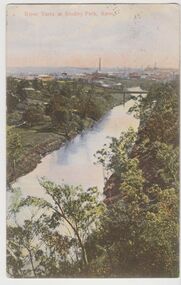
Colour-tinted postcard, titled in red upper left: “RIVER YARRA AT STUDLEY PARK, KEW”. On the divided reverse, the card is addressed to “MISS JOLLEY / MELB. TRAM & O[MNIBUS]. CO / BOURKE STREET, MELB”. The sender has dated the card 21.12.08. In the upper right corner, there is a pink Victorian one penny postage stamp; sent from Melbourne on 22DE 08. (The division of the reverse of the postcard, allowing a message to be written on one half and the address on the other, was not permitted in Australia until 1905.) The manufacturer of the postcard is indicated by the initials “W.T.P”, printed in a green floral diamond, printed centre top. This was the trademark of WT Pater, printers & stationers. William Thompson Pater was born in Melbourne in 1861. His business at 271 Little Collins Street offered Christmas cards, booklets, calendars, and leather goods as well as postcards and albums.Hand-tinted postcard of the River Yarra in Studley Park, Kew. The birds-eye view is of a bridge on the Yarra (Johnston Street?) linking Kew and Abbotsford as it appeared in c.1908. On the Abbotsford side of the river, fields lead down to the river, with some remnant trees. The Kew side of the river, in contrast, due to its steep banks, retains its original vegetation. In the distance is industrial development, in what might be Fairfield and Alphington.“RIVER YARRA AT STUDLEY PARK, KEW”river yarra -- kew (vic.), william thompson pater, w.t.p., postcards -- kew, postcards -- studley park, bridges - yarra river -- kew (vic.) -
 Kew Historical Society Inc
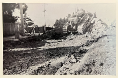
Photograph - Road-making, Studley Park Road, c. 1960
Tom Bentley (1912-1993) was born in Lancashire (UK). From circa 1951, he was the Overseer/Superintendent of Outdoor Works for Kew City Council. Until his retirement in the 1970s, he was based at the Kew Council Depot, located in the former MTB Horse Tram Depot on the corner of Disraeli and High Streets, Kew. Accompanying the set of twelve photographs is a 12-page illustrated biography of the Bentley and Plumridge families, separately kept in the 'Bentley' subject file.Duplicate black and white positive print photograph of road works in Studley Park Road, Kew, carried out under the supervision of Tom Bentley, Overseer/Superintendent of Outdoor Works for the City of Kew. The location at which the photograph was taken is believed, by the donor, to be in the vicinity of Tara Hall (dem. 1960).city of kew, public works, road-making, studley park road, tom bentley