Showing 10893 items
matching village
-
 Whitehorse Historical Society Inc.
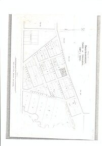
Map - Public Lands Office map, Public Lands Office, Melbourne, Village of Ballyshanassy, 1858, 10 April 1858
A map of the Village of Ballyshanassy by the Public Lands Office, Melbourne. Scale 12 chains equals 5 cmsballyshanassy, parish of nunawading -
 Falls Creek Historical Society
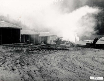
Photograph - Bogong Alpine Village 1944
The images in the Bogong Village Collection were displayed in Bogong Jack’s Tavern for over 20 years and were donated to the Falls Creek Museum when the Tavern closed in 2021. In 1939, the State Electricity Commission of Victoria established a field headquarters at Bogong to house workers and their families for the Kiewa Hydroelectric Scheme which ran from the 1930s to the 1960s. The workmen's camp was originally started with tents and was called Junction Camp. By 1947, the village supported 300 workers and their families. It included 40 houses, a hostel for single staff, a post office, a police station, a medical centre, and a primary school. The staff hostel was known as Kiewa House. At the completion of the Scheme, in the 1960s, the village was opened to public/tourism use. In 1968 the Victorian Education Department acquired the camp buildings and four houses from the State Electricity Commission of Victoria to establish an Outdoor Education Centre which operated for over 50 years. The Kiewa Hydroelectric Scheme was privatized in the 1990s and sold to Southern Hydro, before being acquired by AGL in 2005. In 2023 the Grollo Group signed a 73 year sublease on Bogong Village and has plans for its redevelopment as a workers’ village.These images are significant because they capture the development of Bogong Village as an important element of the Kiewa Hydroelectric Scheme in Victoria.A collection of four black and white images capturing the weather conditions in the Bogong area in June 1944bogong alpine village, bogong high plains, bogong june 1944 -
 Greensborough Historical Society
Business card, Diamond Village Hot Bread & Cake Shop 2018, 2018_
Business card for a local bakery, Diamond Village Hot Bread & Cake Shop, at 78 Nepean Street Watsonia.Business card, white card with red and brown text on yellow background.nepean street watsonia, diamond village shopping centre, diamond village hot bread and cake shop -
 Greensborough Historical Society
Leaflet, Olympic Village - 2000, 1956-2000
Description of the Olympic Village of 1956 comparing what is seen in 2000 with what would have been seen in 1956.2 p. typescriptolympic village, 1956 olympic games -
 Whitehorse Historical Society Inc.
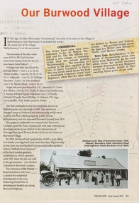
Article - The Bulletin newsletter, The Bulletin Jun - Aug 2022, Our Burwood Village, June 2022
An article about the first settlement surveyed in 1858 in the Burwood area known as Ballyshanassy. It later became Norwood and finally Burwood in 1879.An article about the first settlement surveyed in 1858 in the Burwood area known as Ballyshanassy. It later became Norwood and finally Burwood in 1879.An article about the first settlement surveyed in 1858 in the Burwood area known as Ballyshanassy. It later became Norwood and finally Burwood in 1879.ballyshanassy, albers ernest, boundary road burwood east, dempsey -
 Greensborough Historical Society
Newspaper Clipping, Diamond Valley Leader, Village project in works, 16/08/2017
Hewcom Group won a multimillion-dollar contract to build stage one of the Old Colonists' Association of Victoria's Leith Park retirement village in St Helena.News article 1 page, black text.old colonists association, leith park retirement village, st helena -
 Wonga Park Community Cottage History Group
Photograph (sub-item) - Map of original land settlement in 1890’s – known as ‘the Eight Hour Pioneer village Settlememt’, the square mile around the Wonga Park Store today (red square)
Map of original land settlement in 1890’s – known as ‘the Eight Hour Pioneer village Settlememt’, the square mile around the Wonga Park Store today (red square). -
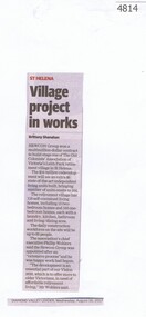
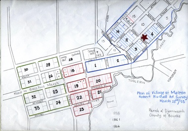 Melton City Libraries
Map, Plan for the Village of Melton, 1853
Site of early village Section numbers 1 - 17 Later became the Flat known as the Common Robert Russell – Surveyor Pinkerton, Sherwin, Bryan, Pyke, Yuille, CollyerMelton Town 1853 Plancouncil -
 Bacchus Marsh & District Historical Society
Map, Village allotments, Parish of Myrniong, County of Bourke
Myrniong is a village 9 kilometers west of Bacchus Marsh. Prior to 1863 the area was known as Blow's Flat. This map which was produced in 1903 and according to the catalogue record of this map held at the State Library of Victoria was based on an earlier map created in 1861. The early layout of streets for the village of Myrniong can be seen on this map. The streets shown are, Main Street, Hardy Street, Blow Street, Myrniong Street, Shuter Street, and Blackwood Street. An area marked as a reserve for a school can be seen between Hardy Street and Main Street.A single page paper map. A cadastral parish map of Myrniong in Victoria, showing numbered land allotments. Photo-lithographed at the Department of Lands & Survey, Melbourne, in 1903. Based on an original map created in 1861. The map is pasted into a bound volume containing 76 maps or plans in total. High resolution digital image stored on BMDHS computer network. Surveyed by John Hardy, Surveyor ; photo-lithographed at the Department of Lands & Survey, Melbourne by T.F. McGauran, 24.12.03myrniong parish plan, myrniong parish maps -
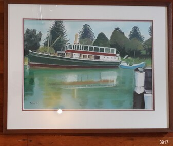 Flagstaff Hill Maritime Museum and Village
Painting - Maritime painting, Carmel Beavis, The Rowitta, 2012
The artist’s comment on her work: “The Rowitta”, Flagstaff Hill. Warrnambool: "This boat was the venue for our daughter’s Wedding. The pastel work was undertaken after a beautiful day at Flagstaff Hill in 2012. I enjoyed working with the shadows and the foliage. Carmel Beavis” The popular steam ferry Rowitta is featured in this pastel picture on canvas by local artist Carmel Beavis. The iconic Norfolk pines stand tall against a blue sky, while colourful reflections shimmer in Flagstaff Hill’s harbour. The historic lifeboat “Warrnambool” is dwarfed by Rowitta’s size. Carmel’s daughter celebrated her wedding on board the Rowitta, which had been a very popular exhibit visitors for around forty years. This picture is one of several that were created by Carmel for her family and friends as a memento of the wedding and a way to keep the memory of Rowitta alive. Some of Carmel’s other works illustrate Flagstaff Hill’s 2017 publication “Tearooms Cookbook”. Some of Carmel’s paintings featured in the Tearooms Cookbook, produced around 2017 for fundraising for Flagstaff Hill. The Rowitta was a timber steam ferry built in Hobart in 1909 using planks of Huon and Karri wood. She was a favourite of sightseeing passengers along Tasmania’s Tamar and Derwent rivers for 30 years. Rowitta was also known as Tarkarri and Sorrentoand had worked as a coastal trading vessel between Devonport and Melbourne as well as along the southern coast of Australia. In 1974 Rowitta was purchased by Flagstaff Hilt to convert into a representation of the Speculant, a historic and locally significant sailing ship listed on the Victorian Heritage Database. (The Speculant was built in Scotland in 1895 and traded timber between the United Kingdom and Russia. Warrnambool’s P J McGennan & Co. then bought her to trade pine timber from New Zealand to Victorian ports and cargo to Melbourne. She was the largest ship ever registered with Warrnambool as her home port, playing a key role in the early 1900s in the Port of Warrnambool. In 1911, on her way to Melbourne, she was wrecked near Cape Otway. None of the nine crew lost their lives.) The promised funds for converting Rowitta into the Speculant were no longer available, so she was restored back to her original configuration. She represented the importance of coastal traders to transport, trade and communication in Australia times before rail and motor vehicles. Sadly, in 2015 the time had come to demolish the Rowitta due to her excessive deterioration and the high cost of on-going repairs. She had given over 100 years of service and pleasure to those who knew her. Early in 2019 Carmel gifted this picture to her friend Shirley Lindsay, who had been President of Wadas Artist Society. A few months later Shirley and her husband John (founding Director of Flagstaff Hill Maritime Village) thought the picture would be appropriate to Flagstaff Hill and presented it with pleasure to the Friends of Flagstaff Hill group later that year.The Rowitta represents the importance of coastal traders to transport, trade and communication in Australia before rail and motor vehicles. The painting is also significant as a record of an exhibit at Flagstaff Hill Maritime Village from is early beginnings. The painting is locally significant for being connected to a local and well known artist Carmel Beavis.Picture, coloured pastel work on canvas in timber frame behind glass. The artist, Carmel Beavis, depicts the steam boat “Rowitta” moored beside the historic lifeboat “Warrnambool” on the lake at Flagstaff Hill Maritime Village. The Rowitta is reflected in the water. The background includes the iconic Norfolk Pine trees. The work was framed by Warrnambool Picture Framing & Gallery in 2012.Signed on front, bottom left “C.L. Beavis”. Artist’s printed label on reverse “The Rowitta, Flagstaff Hill. Warrnambool: / This boat was the venue for our daughter’s / Wedding. / The pastel work was undertaken after a/ Beautiful day at Flagstaff Hill in 2012. / I enjoyed working with the shadows and / The foliage. / Carmel Beavis / Warrnambool. VIC. 3280. / Telephone (03) 5562 1806. / Price: $” Handwritten on artist’s label “250.00” Framer’s printed label “Warrnambool / Picture Framing / & Gallery / 42 Kepler St, Warrnambool 3280 03 5561 5722 / www.wboolframing.com.au” flagstaff hill, warrnambool, shipwrecked coast, flagstaff hill maritime museum, maritime museum, shipwreck coast, flagstaff hill maritime village, great ocean road, picture, pastel, carmel beavis, rowitta steam boat, warrnambool picture framer & gallery, wedding on the rowitta, the rowitta, tearooms cookbook, hobart steam ferry rowitta 1909, tarkarri, speculant, coastal trading vessel, p j mcgennan & co, peter mcgennan, sorrento -
 Robin Boyd Foundation
Slide, Robin Boyd, 1950
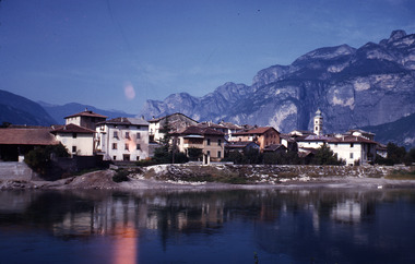
Penleigh Boyd, Robin and Patricia Boyd's son, writes “Prior to 1950 Robin, like most other amateur or hobby photographers, took black and white printed photographs. The oldest slides date from 1950 when Robin and Patricia travelled to Europe on Robin’s Robert Haddon Travelling Scholarship.” In 1948 Robin Boyd was awarded ‘joint first place’ in the Robert Haddon competition for his design of Mildura art gallery. The scholarship helped fund their first overseas trip. Robin and Patricia were passengers on the Greek ship “Cyrenia” departing in May 1950, passing through the Suez Canal and landing in Genoa five weeks later. For six months, they travelled extensively throughout Europe (predominantly driving themselves) - France, Italy, United Kingdom, Sweden, Denmark, Germany, Austria, Switzerland and Spain.Colour slide in a mount. Village near Bolzano in the Dolomite, ItalyItaly / Village / Near Bolzano / Dolomites / Up (All Handwritten)haddon travelling scholarship, haddon, robin boyd, slide -
 Greensborough Historical Society
Map - Map (Copy), C. Hodgkinson, District Surveyor et al, Parish of Yan Yean 1856: Village site during construction of the Yan Yean Reservoir, 1978
Copy of map part Sec. 13, Parish of Yan Yean 1856, Map 3, Village site... Scale: 8 chains to 1 inch. Drawn by C. Hodgkinson, District Surveyor, redrawn by A. R. Blair 1978. 1 p. photocopy of map. yan yean reservoir, yan yean -
 Eltham District Historical Society Inc
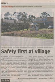
Work on paper - Newspaper article, Diamond Valley News, Safety first at village, 23 September 2009
Monterey Cypress Trees have been removed from along Diamond Street, Eltham at the site of the Eltham Retirement Centre (formerly known as Judge Book Village). In 2021, Judge Book is known as St Vincent's Care Services Eltham. judge book memorial village, aged care, melbourne city mission, seniors, nursing home, aged care facility, judgebook, monterey cypress trees, tree removal, robert weller, ken patterson -
 Ballarat Heritage Services
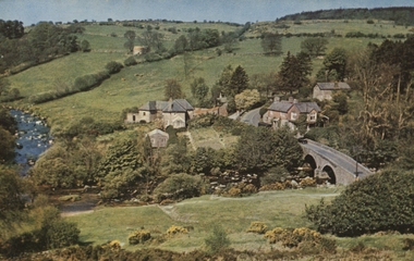
Postcard, Dartmoor
Colour photograph of the village of Dartmoor, with a bridge in the foreground. dartmoor, bridge, village -
 Expression Australia
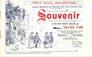
Booklet, Souvenir of the Deaf Mutes' Bazaar and Village Fair (Town Hall Melbourne June 1907)
The Deaf Mutes' Bazaar and Village Fair was held in the Town Hall, Melbourne with sixteen suburbs represented by stalls. The aim in holding the Bazaar and Fair was to raise funds in aid of the proposed farm and home for aged, infirm and feeble-minded deaf mutes in Blackburn.This booklet is significant as a souvenir of the Deaf Mutes Bazaar and Village Fair, the major fundraising event for the proposed farm and home for Deaf adults at Blackburn.Size 14cmHx22cmW; 32 pagesdeaf mutes bazaar and village fair, thomas bent, ernest j. d. abraham, m. l. miller, d. s. abraham, h. sumner martin, councillor weedon, blackburn, melbourne town hall, toorak, camberwell, port melbourne, essendon. hawthorn, footscray, collingwood, malvern, richmond, elsternwick, st. kilda, brunswick, fitzroy, -
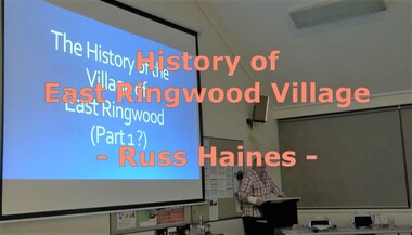 Ringwood and District Historical Society
Mixed media - Video, RDHS Meeting Presentation - "History of East Ringwood Village" - Russ Haines
Digitised video (4.25GB). Duration: 70 minutes. Recorded July, 2019 (Video is available for viewing at Ringwood & District Historical Society Archives by appointment)In this talk, Ringwood and District Historical Society President Russ Haines takes us through East Ringwood's fascinating transition from early roots going back to working class families - some still in the area - to the village of today. East Ringwood is still seen as a quiet place, having resisted large-scale development although many larger blocks now include multiple unit dwellings. -
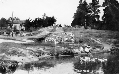 Eltham District Historical Society Inc
Negative - Photograph, Village Pond, near Main Road, Eltham, c.1908
Village Pond, near Main Road, Eltham, c.1908 Reproduced on p57 of 'Pioneers & Painters'. Looking up Dalton Street from across Maria Street (Main Road), near Whitecloud (Jarrold’s cottage) and the Bootmaker’s cottage, to the left (out of view) of the photographer. The residence of the Head Teacher, Eltham State School No. 209, can be seen on the right, the Grant house on the left (site of present day Eltham Clinic). The willow trees south of Jarrold’s Cottage today mark the site of the old pond, which the Eltham Shire Council evidently filled in to stop mosquitos breeding. The pond and its locality was described in an article about Eltham published in The Australasian, May 2, 1903 - “There is the village pond (so essentially English), reflecting in its clear water a quaint cottage, dwarfed by a huge gum tree, an old smithy, and a hostelry, built quite fifty years ago, the flooring-boards of which the landlord informed me with pride were of Singapore cedar, and quite fit for another fifty years' wear. Then there are the village school, the shoemaker's, the drapery store, and the butcher's shop, all seemingly as they were when first they were erected many years ago.”This photo forms part of a collection of photographs gathered by the Shire of Eltham for their centenary project book,"Pioneers and Painters: 100 years of the Shire of Eltham" by Alan Marshall (1971). The collection of over 500 images is held in partnership between Eltham District Historical Society and Yarra Plenty Regional Library (Eltham Library) and is now formally known as the 'The Shire of Eltham Pioneers Photograph Collection.' It is significant in being the first community sourced collection representing the places and people of the Shire's first one hundred years.Digital image 4 x 5 inch B&W Neg Print 16.5 x 25 cm (2) and 9 x 12.5 cm Postcard 9 x 14 cmOn one print "57 and 11 3/8' x 10' deep"shire of eltham pioneers photograph collection, dalton street, duck pond, eltham, grant house, main road, maria street, village pond -
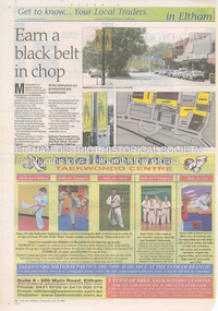 Eltham District Historical Society Inc
Document - Property Binder, Eltham Village Shopping Centre, 950 Main Road, Eltham
Newspaper Advertising supplement: "Earn a black belt in chop" and "Fresh produce, quality service"; Get to know... Your Local Traders in Eltham, Eltham Village Shopping Centre, Valley Weekly, 22 June 2005. Newspaper article: Diamond Valley Leader, 27 February 2019, Bank branch shuts doors.main road, eltham, shops, businesses, anz bank, biba, brumby's eltham, eltham goumet poultry & game, eltham travel, eltham village shopping centre, froot 2 boot, melbourne taekwondo centre, pro-health, travelscene eltham -
 Robin Boyd Foundation
Document - Manuscript, Robin Boyd, Fun and Games at the 'Village Green', 1965
Using 'Village Green Hotel' as an example, Boyd laments on how the development of new Australian Industries' standard of design comfort is rather 'un-Australian'. Further, he criticises how the evolving style of Australian architecture is predominantly inspired by international precedent and questions whether taking foreign elements is considered an Australian style.Original manuscript of an article published as ‘Fun and games at the Village Green’ in The Australian, 03.07.1965.Typewritten, quarto, 4 pagesvillage green, 'un-australian', robin boyd, manuscript, hotel -
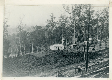 Mt Dandenong & District Historical Society Inc.
Photograph, Harry Walker's Home in Village Settlement 1908, c1908
View of Harry Walker's home taken from waht is now known as Ridge Road, Kalorama. Raspberry crops are in the foreground. This photograph has a detailed inscription on the back handwritten by John Lundy-Clarke in 1974.1908 view of H Walker’s home on Village Settle Lot 2 Section 1. Looking from what is now Ridge Road through the trees on Vil. Set Lot 18 to Barber’s house now known as “Forest Edge” on Vil Set Lot 25 down close to the Olinda Creek on Barbers Road. The Estate Agent’s modern office is on the edge of the patch of raspberries at the lower left as the C.R.B. Mt Dandenong Rd passes just behind Walker’s house crossing the picture behind the raspberries.walker, raspberry crop, forest edge, barber -
 Falls Creek Historical Society
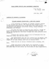
Document - Circular - Village Garbage Collections 1968 Snow Season
Bob (Herman) Hymans (a former member of the Royal Netherlands Navy) was born in Bloemendaal, Holland on 30th September 1922. During World War II he fought against the Japanese in the Dutch East Indies (now Indonesia) and was imprisoned in Changi and on the Burma Railway. After gaining qualifications as a Ski Instructor, Bob arrived in Falls Creek in July 1950. Working as an Instructor and Supervisor at Bogong Lodge, Bob decided his future was in accommodation. He was successful in negotiating an indenture for land from the State Electricity Commission (SEC). It took Bob two years to build his Grand Coeur Chalet but, tragically, it was burned down in August 1961. Bob also built the first Chairlift in Australia. This was a single chairlift and the structure was built from wooden electricity poles. He was constantly full of new ideas and proposals for the village. Bob Hymans died on 7th July 2007. This Collection of documents and letters tells the story of Bob's endeavours to develop Falls Creek into the ski village it is today.This letter is significant because it reflects the relationship between Bob Hymans and the Management Committee.A letter from the Management Committee outlining a new contract with "Yellow Horse Snow Services Pty. Ltd." to carry out three garbage collections weekly. To cover the cost of this service a charge of $1.50 per bed would be levied.falls creek tourist area management committee, falls creek administration, bob hymans -
 Eltham District Historical Society Inc
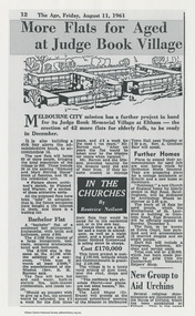
Work on paper - Newspaper article, More flats for aged at Judge Book Village, 11 August 1961
Article published in The Age, Friday, August 11, 1961, p12 as part of the "In the Churches" column by Beatrice Neilson describing the plans for expansion by Melbourne City Mission for the Judge Book Memorial Village at Eltham. Includes image of the architect's sketch. Article also refers to plans or new sites by the Mission at Kilsyth, Hawthorn, Sandringham and East Brunswick. In 2021 Judge Book is now known as St Vincent's Care Services, Eltham.judge book memorial village, aged care, melbourne city mission, beatrice neilson, the age, sister mildred greenwood, rev r h barnes, seniors, nursing home, aged care facility, judgebook -
 RMIT Design Archives
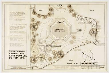
Work on paper - Architectural drawings, Aboriginal Keeping Place, Shepparton International Village
Site plan drawing of the Shepparton Aboriginal Arts Council building, now known as the Bangerang Cultural Centre. The building is located in the Parkside Gardens, formerly the Shepparton International Village, and is the first Aboriginal cultural museum developed and managed by the Aboriginal community. The building is part of the Victorian Heritage Register. Romberg designed the building in conjunction with project instigator and Bangerang Elder, John Sandy Atkinson, OAM. At the request of Romberg, Atkinson created some concept sketches for the building from which Romberg designed the finished structure.Site PlanInitialed in grey pencil, bottom right: 'F.R'architecture, museum -
 Melbourne Tram Museum
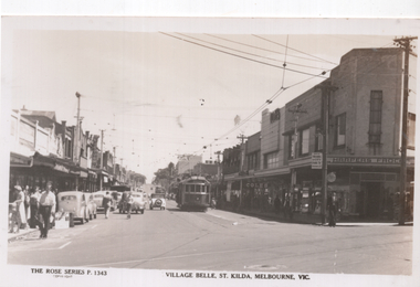
Postcard, Rose Stereograph Co, "Village Belle, St Kilda, Melbourne Vic", early 1950s
Rose Series postcard No. P 1343, titled "Village Belle, St Kilda, Melbourne Vic" showing W2 568 (Moreland Route 15) at the St Kilda Beach terminus in Ackland St. Another W2 is further behind. A uniformed tramway employee is walking across the road, underneath a MMTB sign advising of Trams to the City and a Fare of 5d and child fares of 2d. In the background is the Coles store and Harpers Frocks. In the foreground are tram tracks for the Victorian Railways St. Kilda to Brighton Beach line in Buckly Street.Yields information about Ackland St, St Kilda early 1950s.Postcard - printed real photograph with Rose Stereograph Co. name on the rear.trams, tramways, village belle, ackland st, route 15, st kilda, w2 class, tram 568 -
 Ringwood and District Historical Society
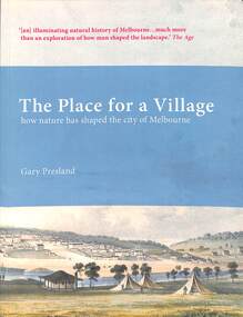
Book, Dr Gary Presland, The Place for a Village - Gary Presland, 2012
Dr Gary Presland studied history at LaTrobe University, Melbourne and archaeology at the University of London. His major research interests have been in Aboriginal and natural history of the Melbourne area. He researched The Place for a Village as a PdD, in the Department of History and Philosophy of Science at The University of Melbourne. His previous books include Aboriginal Melbourne and For God's sake send the trackers. Gary Presland is a Fellow of the Royal Historical Society of Victoria, an Honorary Fellow at The University of Melbourne and an Honorary Associate of Museum Victoria, where he was the 2001 Thomas Ramsay Science and Humanities Fellow. He is a current Editor of The Victorian Naturalist, published by the Field Naturalists Club of Victoria, since 1884.The Place for a Village won The Victorian Community History Awards 2009 for best publication.How nature has shaped the city of MelbourneHandwritten notation first page - With best wishes, Gary Presland 22 February 2020. -
 Kiewa Valley Historical Society
Photographs x 2 1. Lake Guy & Bogong Village 2. Bulldozer moving rocks
1. In 1940 Field Headquarters for the Kiewa Scheme were established at Bogong with office, workshop facilities and accommodation for workmen, staff and some families constructed. (There had been a 'tent camp' on this site in 1939 but was destroyed by bushfires) Construction of accommodation continued until 1947. A total of 40 houses plus a hostel for single staff, post office, police station, medical centre and primary school all with water and sewerage and electricity supply. The staff hostel was known as Kiewa House and is now occupied by the Education Department. Lake Guy was named after Mr. L.T. Guy who was the Resident Engineer in charge of construction work and associated activities on the Kiewa area. He held this position from 1939 to November 1946 when he was transferred to Head Office. 2. Example of the type of heavy machinery used in clearing and building of Lake Guy, Bogong Village and Clover Dam 1. The Bogong Township was developed firstly as an accommodation centre (base camp) for construction workers employed under the Kiewa Hydroelectric Scheme. At the completion of the scheme, in the 1960's, the village was opened to public/tourism use. Strict environmental control has not allowed for any extensive redevelopment in tourist accommodation and basically restricted it to the accommodation initially built for the construction workers. Lake Guy is one of the many water storage reservoirs used to supply the power stations their main power to run the huge turbines generating the final product, electricity 2. Pictorial record of the types of machinery used in the development of Bogong Village and the Hydro-electricity scheme including the Clover Dam. Note the lack of safety equipment worn by construction workers of the period. 2 black and white photographs taken at Bogong 1. Lake Guy with Bogong Village in the background 2. Workman in bulldozer clearing rocks, possibly for construction at Bogong1. Handwritten in blue ink on back of photo 'Lake Guy showing Bogong Village' 2. No markingslake guy, bogong village, secv -
 Eltham District Historical Society Inc
Photograph - Digital Photograph, Marguerite Marshall, Eltham Retirement Centre (Judge Book Memorial Village), Diamond Street, Eltham, 23 October 2006
Thousands of elderly people at this centre have contributed much. Published: Nillumbik Now and Then / Marguerite Marshall 2008; photographs Alan King with Marguerite Marshall.; p161 Thousands of elderly people, who have contributed much to Nillumbik and beyond, have made their home in the treed Eltham Retirement Centre. The centre, which opened in 1956, has housed the disadvantaged in particular, through good times and hard, including floods, fire and even burglaries. As part of the Melbourne Citymission, a non-denominational Christian organisation that cares for people living with disadvantage, the centre was built to celebrate 100 years of the Melbourne Citymission’s work since 1854. Standing on a former poultry farm called Willandra (Still Waters), the centre includes independent units, hostel, nursing home accommodation and a Day Therapy Centre, which is available for non-residents as well. Despite being metres from the busy Main Road and railway station, the centre provides a quiet oasis on 6.8 hectares bordered by the Diamond Creek to the west, and the railway line to the east. The centre was originally named Judge Book Memorial Village after Judge Clifford Book, Deacon of the Collins Street Baptist Church. Book was also President of the Baptist Union of Victoria and Grand Master of the Masonic Lodge. He was so respected that, at his death, several Pentridge prisoners asked to attend his funeral. In 1993 the centre’s name was changed to clarify that it was part of the Melbourne Citymission. However Judge Book’s name continues in the Judge Book Memorial Garden, opened in 2006. The Diamond Creek has flooded the centre several times, however rarely causing serious damage. Volunteer Alan Field recalls a flood in 1974 when the resident manager Reverend Norman Pearce and his wife, were rescued by boat from their home with their budgerigar. On February 3, 2005, when the creek almost flooded Metzner Hall, 35 ambulances evacuated residents to nearby nursing homes, hostels and local homes. Residents were also evacuated during the 1965 bush fire, but fortunately a change of wind direction saved the centre. Residents have also endured several burglaries. Despite much rebuilding and modernisation over the years, traces of the original farmhouse remain in the administration areas. In 1991 the Willandra Hostel was built and in 2001 the Eltham Lodge Nursing Home with each room having a garden view. Several buildings are named after people who have given special service to the centre including the Norman Pearce Day Hospital after general manager and pastor Rev Pearce. Metzner Hall was named after the Metzner family who had been active in the auxiliary since it began and had donated generously to the Recreation Hall fund.3 A bridge was named after Sister Lila Murray who had worked at the village for 42 years in various capacities including as relieving manager. Field remembers Sister Murray as ‘the Mother Teresa and soul of what the village aspired to, with love and care’. Since 1957 the Eltham Auxiliary, later called the Residents’ Association, has worked to improve the residents’ quality of life by volunteering and raising funds. An outstanding volunteer, Field, who was drawn to the centre in 1971 with his wife Chris, has held positions on the early Eltham boards, auxiliaries and Residents’ Association. Much of his work has been supporting people with no family and those of limited means. He says he and his wife look at their work as having shared ‘our lives with amazing people’. The wealth of experience and wisdom in the Retirement Village has benefited many people, including local school children. Residents have acted as proxy grand-parents at local schools, by assisting small learning groups or telling their life stories. Conversely, students from local schools have visited to perform, or to assist in programs like craft activities. Resident Val Bell, whose mother Rose Bullock lived at the centre before her, sums up the centre’s most important attribute for her: ‘The Christian care. They could not be more caring’.This collection of almost 130 photos about places and people within the Shire of Nillumbik, an urban and rural municipality in Melbourne's north, contributes to an understanding of the history of the Shire. Published in 2008 immediately prior to the Black Saturday bushfires of February 7, 2009, it documents sites that were impacted, and in some cases destroyed by the fires. It includes photographs taken especially for the publication, creating a unique time capsule representing the Shire in the early 21st century. It remains the most recent comprehenesive publication devoted to the Shire's history connecting local residents to the past. nillumbik now and then (marshall-king) collection, diamond street, eltham, eltham retirement centre, eltham retirement village, judge book memorial village -
 Kew Historical Society Inc
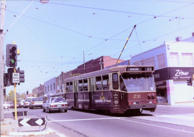
Photograph - A Class 231 in Doncaster Road, North Balwyn Village, 1990
This colour photograph, with 15 others are enlargements gifted to the Society by Mel Lawrence in 2016. They were taken at a commemorative event from the Kew Tram Depot. Laminated colour enlargement of an A Class 231 in Doncaster Road, North Balwyn Village during a re-enactment from the Kew Depot in 1990.Annotation reverse: "Kew Depot 1990. A Class 231 in Doncaster Road, North Balwyn Village."kew tram depot, a class trams, trams -- melbourne -
 Flagstaff Hill Maritime Museum and Village
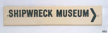
Sign - Shipwreck Museum sign, Flagstaff Hill Historic Park Planning Board, Shipwreck Museum, ca. 1975
This sign is painted on both sides. It was attached to the bluestone wall on the western wing of the Lighthouse Keeper's Quarters, the Assistant Keeper's Quarters, at Flagstaff Hill Maritime Museum and Village for almost 50 years. The Complex was opened to the public on December 11, 1975, and officially opened by Victorian Premier Sir Rupert Hamer on July 8th, 1977. The sign's reverse side reads "Loch Ard Peacock & Museum". The three rooms had displays behind glass showing various ships' fittings, cargo and personal belongings recovered from significant shipwrecks along the southwest coast of Victoria. There was also a display of information about the mysterious Mahogany Ship or Ancient Wreck. The shipwreck artefacts were recovered by local divers in the 1960s and early 1970s. Also on display was the famous Loch Ard Peacock, created in 1873, survived the shipwreck in 1878, was purchased by Flagstaff Hill in 1975 and announced as being on display in The Standard of September 15, 1975. In about 1984 the other side of the sign was painted "SHIPWRECK MUSEUM" and re-displayed on the building. The Loch Ard Peacock was by that time on display in the Entrance building; plans were underway on August 31st 1984 to build a Hall for its unique display. In February 2023 the sign was removed from the building, which was undergoing restoration and preparation for use as a new Temporary Exhibition space. The Loch Ard Peacock continued its journey around the Village; it was moved from the Entrance to the Village's newly completed Public Hal in 1986. It also spent a short time in the Stella Maris Tea Rooms. This was likely around 1998, when the Common School had moved from the Chartroom building to what had been the Public Hall. The Loch Ard Peacock was once again moved in around 2001, this time to be the central attraction and meeting place in the Great Circle Gallery, which opened on December 31st 2002. The sign continued to be displayed on the western wing of the Lighthouse Keeper's Quarters until February 2023. This wing has now been restored and re-fitted to become a facility for short-term exhibitions. A section of the original internal wall frame and wallpaper that couldn’t be kept in the building due to preservation issues have been saved and become sort of the Flagstaff Hill Collection. The sign has guided the visitors of Flagstaff Hill Maritime Museum and Village to the exhibits of artefacts from historic and significant shipwrecks. It has connected the current generations to the people and objects of the past, leading to a better understanding of our Colonial history.Sign, wooden, rectangular, with a hole through each short side. The front and reverse have different painted text. Cream paint for the background colour, green paint for the lettering, and the reverse has a white painted border. The front has an arrow painted on the right-hand side. The sign was used at Flagstaff Hill since its opening.Text on front "SHIPWRECK MUSEUM >" Text on back "LOCH ARD PEACOCK / & MUSEUM"flagstaff hill maritime museum and village, warrnambool, great ocean road, shipwreck coast, sign, building sign, shipwreck museum, loch ard peacock & museum, flagstaff hill history, assistant lighthouse keeper's cottage, assistand lighthouse keeper's quarters, public hall, common school -
 Bendigo Historical Society Inc.
Map - JACK FLYNN COLLECTION: VILLAGE OF BETLEY, 30/06/1874
Map: Village of Betley, on the Bet Bet Creek, Parish of Dunolly. Parish plan.Photo Lithographed at the Department of Lands and Survey Melbourne by J. Noone 30.6.74map, gladstone, village, betley, bet bet creek, dunolly