Showing 288 items matching "warrnambool maps"
-
 Warrnambool RSL Sub Branch
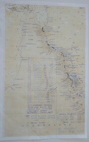
Map - 1947 Minesweeping map, North Queensland minesweeping map, unknown
1947 an after-effect od WW2Laminated A3 Map plus A4 map in pocket (copies of original)shows location of minefields to be cleared in 1947 and names of minesweeping ships!947 ran history -
 Warrnambool and District Historical Society Inc.
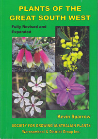
Book, Star Printing Terang Victoria. 978-0-9751360-1-0, Plants of the Great South West 2013 Second Edition, 2013
Second edition (revised a& expanded edition) First edition 2004. Guide to the indigenous plants of South West Victoria. South West Victoria: Nelson – Port Campbell. Zone A.B.C & D. Local maps BioregionsCard cover green) gloss white paper. End papers. Map 1&2. 6 pages credits, title, table of contents, forward, acknowledgements, disclaimer, websites. 348 pages. Colour maps & photographs. References & reading. Index plantsof western victoria, kevin sparrow, warrnambool -
 Warrnambool and District Historical Society Inc.
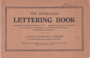
Booklet - Lettering Book, Halstead Press Pty Ltd, The Australian Lettering Book, 1945
Author Herbert Newell. Alphabets of varied fonts, headings, flourishes, plans, numerals, sketch maps, scrolls, shading, common errors, compass points. Especially designed for use in Australian Schools, offices of Lawyers, Architects, Surveyors, Engineers, Engravers, and Draughtsmen. Table of contentsThe author is a teacher of show card and ticket writing at Sydney Technical College. Book used by many students and offices. Note by the publishers provides standards for the correct form of the characters. Light brown light card cover with black ink font and border patterns. 32 Cream pages with black ink. Two staples. Hand written name on top of outline black border S. R Coleston. Price 3/9warrnambool, lettering book, angus & robertson limited, s.r. coleston, herbert newell -
 Warrnambool and District Historical Society Inc.
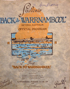
Programme - Back to Warrnambool 1930 official souvenir program, January, 1930
This booklet contains the Program for the Back to Warrnambool Celebrations for 1930. It contains a brief history of the town and photos of current council Office bearers and local scenic spots. There is also a map of the town and a large number of advertisements for local businesses. Back to Warrnambool celebrations were an important event on the social calendar and were run over a number of years in the town. This program is one glimpse into the city and its people in 1930. Some of the events held over the week included processions, sports Carnivals, concerts, card playing, Church services and local tours. Many of the advertisements are for businesses of long standing and importance to the prosperity of the town. Twenty page Booklet with light card, grey, mottled cover. Text in brown and blue. Picture of Warrnambool main beach in centre. Price 2/- in bottom right corner. Back cover has full page advertisement for Bruce and McClure. Text and illustrations are brown. M Armstrong is written in blue biro on top right corner. Song “Back to Warrnambool,” written and composed by Reg A.A. Stoneham,” is printed below picture on front cover. Published by A.A. Stoneham, 241 Carlisle St, Balaclava.younger pty ltd, warrnambool, back to warrnambool, 1930, souvenir program, warrnambool cordials, morse pty, swinton, warrnambool cheese and butter factory, batros shoes, tattersalls hotel, bruce and mcclure, warrnambool woollen mill, reg a. a. stoneham -
 Warrnambool and District Historical Society Inc.
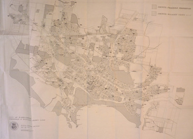
Map - City of Warrnambool Freehold and Managed Crown Land, City of Warrnambool Council, 14th April 1994
... Street (south of Merri St) Warrnambool great-ocean-road This map ...This map was drawn up by the City of Warrnambool Council staff to provide information on the land in Warrnambool that was owned or managed by the Council.This map is of considerable importance as it gives information in map form of the Warrnambool land that is owned (freehold) by the City of Warrnambool and the land that is managed Crown land. This is of interest to researchers and those seeking information on specific areas of land in Warrnambool.This map has digital mapping. The map has a white background with black and white mapping details of Warrnambool. It has the City of Warrnambool seal. Scale of map: 1:7500warrnambool city council, warrnambool -
 Warrnambool and District Historical Society Inc.
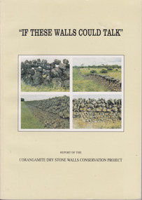
Book, If These Walls Could Talk, 1995
This publication is a result of funding made to the Corangamite Arts Council in 1990-91. Its aims were to identify and research the dry stone walls of the region, to raise their profile and through workshops continue the skills of those wanting to learn more about the craft. The book gives the history of the practice in the area and the various different styles with photographs to illustrate the different features. It also has a number of first- hand accounts written by stonewallers.This study has social, historical, artistic and interpretive significance as the walls are an important feature of the district. The account written by former builders of the walls provides an interesting insight into the various styles and reasons for their construction.Light green card cover. Front cover has 4 photographs of dry stone walls with title and other text in black. Back cover is plain. 144 pages. It contains a large number of black and white photographs of stone walls from around the district as well as maps. Report of the Corangamite dry stone walls Conservation project.dry stone walls, corangamite stone walls, warrnambool and district history, constructing dry stone walls -
 Warrnambool and District Historical Society Inc.
Book, Warrnambool Botanic Garden Masterplan, February 1995
This Warrnambool Botanic Gardens Study and Report was funded by the National Estate Grants Program of the Australian Heritage Commission and the City of Warrnambool. It was monitored in progress by a Steering Committee consisting of representatives of the Botanic and Public Gardens Advisory Committee, the Warrnambool City Council, Friends of the Warrnambool Botanic Gardens and National Estate Grants Program representatives and community representatives. The Warrnambool Botanic Gardens were first sited close to the Hopkins River in 1859. In 1869 the gardens were relocated to the present day location in Botanic Road. This plan is of some importance as it gives an overview of the history and current condition in 1995 of the Warrnambool Botanic Gardens and draws up a plan for its future development. It is useful for research and for consideration by the City Council today of policy making and further development of the gardens. This is a publication containing a master plan for the Warrnambool Botanic Gardens. It has a section on acknowledgements, a summary, eight chapters, and 14 appendices. The pages are bound with plastic rings, the front cover is plasticized with an aerial photograph of the Botanic Gardens and surrounds and the back cover is lightweight cardboard. The pages contain printed material, fold out maps, sketches and diagrams and many photocopied photographs.Front Cover: City of Warrnambool, Warrnambool Botanic Gardens, Conservation and Development Plan, Jill Orr-Young, Patrick Mallon, SF Consultants Pty Ltd, February 1995. warrnambool botanic gardens, warrnambool -
 Warrnambool and District Historical Society Inc.
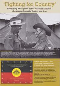
Booklet, 'Fighting for Country' Honouring Aborigines from South West Victoria who served Australia during war time, February 2014
This booklet was collated and printed for the 2014 Lake Bolac Eel Festival, ‘Return to Country’. The author, Peter Bakker, has spent several years researching the part played by south western Victorian aborigines and this booklet details the results of this research. Several of the soldiers came from the Warrnambool area.This is a booklet of ten pages with printed material and black and white and colour photographs and a map.Front Cover: ‘Fighting For Country – Honouring Aborigines from South West Victoria who served Australia during War Time’ (plus other printed material) Back Cover: Map and List of Service Men and Women of Aboriginal Descent with connections to South West Victoria aborigines from south west victoria, return to country, lake bolac eel festival, peter bakker, world war one, world war two, korean war, vietnam war -
 Warrnambool and District Historical Society Inc.
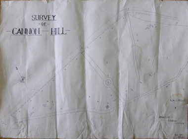
Work on paper - Project, Cannon Hill 1939, 1939
... Street (south of Merri St) Warrnambool great-ocean-road A map ...A map thought to be a school project depicting the layout of Cannon Hill, a popular lookout in Warrnambool.A locally drawn map indicative of school work from the 1930’s.A map thought to be a school project depicting the layout of Cannon Hill, a popular lookout in Warrnambool.Drawn by R Graham. Checked 13/02/1939 T E Wingrovecannon hill, school project 1939 -
 Warrnambool and District Historical Society Inc.
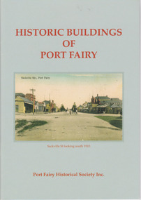
Booklet, Port Fairy Historical Society, Historic Buildings of Port Fairy, 2012
Port Fairy, a small town in Western Victoria established in 1836, has an exceptional collection of public buildings and dwellings dating from the 1840s. This booklet gives short descriptions of 58 of these historic buildings, many with accompanying photographs. These include many buildings in Gipps and Sackville Streets, the Powder Magazine, some hotels, the Drill Hall, Dublin House, the Port Fairy Cemetery and several schools and churches. This booklet is useful for those seeking quick information on the historic buildings in Port Fairy and for those wanting to undertake a walk around the town’s historic spots. TryBooking will show you the full breakdown on the Booking Payment Report and the Event Revenue Itemised Report so you can clearly see the ticket sales, credit card processing fee and the funds that are yours. Front cover: ‘Historic Buildings of Port Fairy, Port Fairy Historical Society Inc.’ Photograph on front cover: ‘Sackville Str. Port Fairy’, ‘Sackville St. looking south 1910’ Back cover map: ‘Port Fairy Historic Buildings’ warrnambool, port fairy, western victoria, historic buildings -
 Warrnambool and District Historical Society Inc.
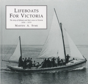
Book, Marten Syme, Lifeboats For Victoria, 2001
History of lifeboats and their crews in Victoria from 1856 to 1879This is a paper back book with a plasticized cover. It has 76 pages and an index. The cover is olive-green in colour with images of a life boat and a lifeboat service certificate. The book contains printed material, diagrams, maps, photographs and other illustrations.non-fictionHistory of lifeboats and their crews in Victoria from 1856 to 1879lifeboats, shipwrecks, port fairy lifeboats, warrnambool lifeboats, history of warrnambool -
 Warrnambool and District Historical Society Inc.
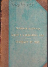
Document - Victorian Railways. Koroit & Warrnambool Line. Contract No. 2937, Circa 1888
The Victorian Railways began in 1854 and in the first 14 years up to 1868 had managed to complete about 250 miles of track. The next 60 years saw the system expand to nearly 3000 miles. By 1931 every town with a population over 500 had its own railway station. Early Victorian railway maps indicate that the extension from Colac to Warrnambool and then onwards to Koroit, occurred in the period of the 1880’s when the act known as the Octopus act saw a rapid expansion of lines. At the time there was much debate over where the expansion of the lines should take place, with one of the prime considerations for Warrnambool was the impact it would have on its port.The building of the railway to Warrnambool and onward to Koroit was a significant event for the town. Green cloth cover with tan suede corner points and spine. Title printed in gold on front cover. Title printed in gold on red on spine. 92 pages. The contract is printed and includes handwritten entries with specifications.Handwritten on front cover and inside front cover ” Copy for Engr in Chief” .On Page 2 transferred to Allan Reid * 24/1/88 Co Briscoe & Co Little Collins Street, Melbourne.warrnambool, railways, warrnambool to koroit railway, victorian railways contract no 2937 -
 Flagstaff Hill Maritime Museum and Village
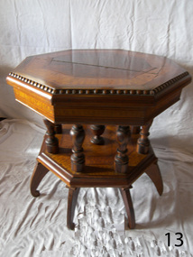
Furniture - Table, Johann A. Landmann, 1853
This decorative octagonal inlaid table was made by Johann Landmann as a wedding present to his wife and was donated to Flagstaff Hill by the wife of Landmann's great-grandson. Landmann (or Landman, also known as August Landmann) was born in 1826 in Ganhor, Silesia, Prussia. At the age of 20, he travelled through Europe, working from town to town as a cabinet maker. At 26 years old he returned to Germany, married Anna Rosina in Wahlstatt, Prussia, and on the same day sailed for Australia on the Wilhelmsburg in 1853, the year the ship was registered. The Wilhelmsburg was a three-masted, square-rigged sailing ship built at Reiherstieg, Hamburg, and registered in Hamburg on 27th April 1853. On her maiden voyage in 1853, the ship sailed from Hamburg, Germany, to Australia with 510 passengers on board, including emigrants under the Bounty Scheme. Johan Landmann was one of the passengers. The Wilhelmsburg arrived in Hobson’s Bay, Melbourne after sailing for 100 days. Johann spent a week in Melbourne then travelled to Warrnambool aboard the Merry Kitty, arriving fourteen days later. Johann had landed in Melbourne with only 16 shillings in his pocket and by the time he arrived in Warrnambool, he only had one shilling and sixpence left. He also had very limited ability to speak English. He settled in the Allansford area, near Warrnambool, together with other families from Germany and went on to play a significant role in the history of Warrnambool. Johann worked as a cabinet maker in Warrnambool, making the first coffin in the Warrnambool cemetery. He also worked as a general merchant. He built many of the earliest shops in Warrnambool, and the first paddle boat used on the local Hopkins River. He made models of Warrnambool’s Ozone Hotel and Presbyterian Church; the model of the Hotel is now in the Warrnambool Art Gallery, and the model of the Presbyterian Church has been in the care of the Warrnambool & District Historical Society since around 2017. One of Landmann's residences was a two-storey building in Henna Street Warrnambool where he, lived upstairs and operated his business downstairs. After he retired Landmann built a ‘handsome stone residence’ at 30 Mickle Street, Warrnambool, where he lived until his death in June 1920; he was aged ninety-five. “Landmann Street” in Warrnambool has been named after Johann and appears on a map in 1872. He has also been honoured on Warrnambool’s Pioneer Memorial Board which is displayed at the Warrnambool and District Historical Society. Landmann's son Adolph Fritz Landmann (Fritz Landmann) born in 1861, was a Councillor from 1905 to 1915, and Mayor of Warrnambool from 1912 to 1915. The Wilhelmsburg sailed from Hamburg in 1863 heading for Queensland, Australia, but in December the vessel was wrecked off the coast of Holland during storms, with the loss of 247 lives.The table is significant as an early Warrnambool historical artefact with a connection to the maiden voyage of the ship Wilhelmsburg a vessel that holds the record for the number of passengers carried in one journey on a small vessel. Johann Landmann is regarded as a significant and historical figure in the development of Warrnambool as one of the earliest pioneers, not only as a businessman but the civic duties he undertook. First as a councilman and later the mayor of Warrnambool.Table, wooden, inlaid octagonal, two tiered with eight pillar supports and seven turned legs (one leg missing). Two large cracks in table top. A handwritten inscription is beneath the table top.Inscription is indecipherable. shipwrecked coast, flagstaff hill, flagstaff hill maritime museum, shipwrecked artefact, warrnambool, table, octagonal table, inlaid woodwork, wilhelmsburg, johann landmann, augustus landmann, fritz landmann (warrnambool mayor), ozone hotel warrnambool, inlaid table -
 Flagstaff Hill Maritime Museum and Village
Container - Trinket Box, Johann A. Landmann, 1853
This trinket box was made by Johann Landmann during his journey on the sailing ship Wilhelmsburg and was donated to Flagstaff Hill by the wife of Landmann's great-grandson. Landmann (or Landman, also known as August Landmann) was born in 1826 in Ganhor, Silesia, Prussia. At the age of 20, he travelled through Europe, working from town to town as a cabinet maker. At 26 years old he returned to Germany, married Anna Rosina in Wahlstatt, Prussia, and on the same day sailed for Australia on the Wilhelmsburg in 1853, the year the ship was registered. The Wilhelmsburg was a three-masted, square-rigged sailing ship built at Reiherstieg, Hamburg, and registered in Hamburg on 27th April 1853. On her maiden voyage in 1853, the ship sailed from Hamburg, Germany, to Australia with 510 passengers on board, including emigrants under the Bounty Scheme. Johan Landmann was one of the passengers. The Wilhelmsburg arrived in Hobson’s Bay, Melbourne after sailing for 100 days. Johann spent a week in Melbourne then travelled to Warrnambool aboard the Merry Kitty, arriving fourteen days later. Johann had landed in Melbourne with only 16 shillings in his pocket and by the time he arrived in Warrnambool, he only had one shilling and sixpence left. He also had very limited ability to speak English. He settled in the Allansford area, near Warrnambool, together with other families from Germany and went on to play a significant role in the history of Warrnambool. Johann worked as a cabinet maker in Warrnambool, making the first coffin in the Warrnambool cemetery. He also worked as a general merchant. He built many of the earliest shops in Warrnambool, and the first paddle boat used on the local Hopkins River. He made models of Warrnambool’s Ozone Hotel and Presbyterian Church; the model of the Hotel is now in the Warrnambool Art Gallery, and the model of the Presbyterian Church has been in the care of the Warrnambool & District Historical Society since around 2017. One of Landmann's residences was a two-storey building in Henna Street Warrnambool where he, lived upstairs and operated his business downstairs. After he retired Landmann built a ‘handsome stone residence’ at 30 Mickle Street, Warrnambool, where he lived until his death in June 1920; he was aged ninety-five. “Landmann Street” in Warrnambool has been named after Johann and appears on a map in 1872. He has also been honoured on Warrnambool’s Pioneer Memorial Board which is displayed at the Warrnambool and District Historical Society. Landmann's son Adolph Fritz Landmann (Fritz Landmann) born in 1861, was a Councillor from 1905 to 1915, and Mayor of Warrnambool from 1912 to 1915. The Wilhelmsburg sailed from Hamburg in 1863 heading for Queensland, Australia, but in December the vessel was wrecked off the coast of Holland during storms, with the loss of 247 lives.The trinket box is significant as an early Warrnambool historical artefact with a connection to the maiden voyage of the ship Wilhelmsburg a vessel that holds the record for the number of passengers carried in one journey on a small vessel. Johann Landmann is regarded as a significant and historical figure in the development of Warrnambool as one of the earliest pioneers, not only as a businessman but the civic duties he undertook. First as a councilman and later the mayor of Warrnambool. Trinket box, wooden, with inlaid timber patterns and images. The design includes a mirror with a hidden compartment inside the hinged lid, a removable inner tray divided into compartments, and a fitted brass lock. The trim around the base is angled to widen the base. Images on the lid and three sides represent sailing vessels and a building. The lid and corners have a rope-edge design. Panels of the top and three sides have an intricate inlaid pattern featuring various wood grains. Images are framed by lines etched into the wood. The inside corners of the frames have inlaid quarter-circles of contrasting woods, resembling photograph corners.shipwrecked coast, flagstaff hill, flagstaff hill maritime museum, maritime museum, shipwrecked artefact, warrnambool, trinket box, inlaid woodwork box, wilhelmsburg, landmann, johann landmann, augustus landmann, landman, fritz landmann (warrnambool mayor), presbyterian church warrnambool, 30 mickle st warrnambool, ozone hotel warrnambool, johann carl augustus landmann, jewellery box -
 Flagstaff Hill Maritime Museum and Village
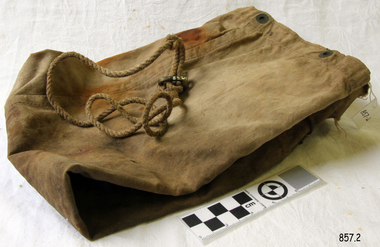
Functional object - Ditty Bag, Late 19th century
A Ditty Bag (or box) was originally called “ditto bag” because it contained at least two of everything, two needles, two spools of thread, two buttons, etc. With the passing of years, the “ditto” was dropped in favour of "ditty" and remains so today. Before World War I, the Navy issued ditty boxes made of wood and styled after footlockers. These carried the personal gear and some clothes of the sailor. Today, the ditty bag is still issued to recruits and contains a sewing kit, toiletry articles and personal items such as writing paper and pens. Another source says a Ditty Box or Ditty Bag is possibly from the Saxon word “dite”, meaning tidy or from the English word “dittis”, a type of canvas material. A small box or bag in which a sailor kept his valuables such as letters, small souvenirs and sewing supplies.An item that is socially significant as it gives insight into a sailors life aboard ship and is another part of marine history. Items such as these although they were regarded at the time as everyday objects help us now to map various aspects of marine archaeology thorough the ages.Sailors Ditty Bag, canvas bag for holding all the sail making and roping tools, with tie and brass clasp. Holed.Noneflagstaff hill, warrnambool, shipwrecked-coast, flagstaff-hill, flagstaff-hill-maritime-museum, maritime-museum, shipwreck-coast, flagstaff-hill-maritime-village -
 Flagstaff Hill Maritime Museum and Village
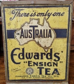
Container - Tin Tea Container, Wilson Bros, 1900-1940
The tin was made by Wilson Bros, Melbourne, for Edwards' Ensign Tea Pty Ltd, Melbourne, Victoria, Australia, 1900-1940. There was a fire at their factory in Flinders Street Melbourne on April 30, 1921 which completely destroyed the building. New premises were obtained at 310/18 King Street Melbourne in 1923. there continued to be bill board advertisements for Ensign tea at the King Street address, also regular adverts in the Argus newspaper during1942.An Australia icon during the first half of the 20th century as tea drinking was a popular past time and social activity.Container for tea with hinged lid. Label yellow with map of Australia. Lid is coming away on one hinge. "Edwards Ensign Tea" On label "Edwards Ensign Tea"flagstaff hill, warrnambool, shipwrecked coast, flagstaff hill maritime museum, maritime museum, shipwreck coast, flagstaff hill maritime village, great ocean road, tea tin, tea caddy, drink, container, wilson bros, ensign tea -
 Flagstaff Hill Maritime Museum and Village
Functional object - Ship's Wheel
This wooden ship's wheel originally had eight spokes but four are no longer in their sockets. One of the spokes has been shaped. Both sides of the wheel have a brass cap over the centre of the hub, covering the wooden hub. The wood is split and cracked, and parts of it have small holes, a sign of being affected by the sea worm. Thick encrustations are on parts of the wheel, showing that it has been on the sea bed for quite some time. The donor is a Warrnambool resident. Years ago he was cray fishing at King Island, which is in Bass Strait, northwest of Tasmania. His craypot got stuck in a reef so a diver helped him by retrieving the craypot for him. While the diver was underwater he also stumbled across the ship's wheel, which he gave to the donor. The Bass Strait is a very narrow route that was difficult and dangerous to navigate in the early 19th century, before good maps, communications and lighthouses were installed. The area, including King Island, is the graveyard of many ships that almost made it to their destination of Melbourne along Australia's treacherous coastline. Around King Island alone, many ships and lives were lost. There is no information about the history of this ship's wheel. Its condition shows that the item has been under the water for a long time. However, there is no evidence that it came from a shipwreck. It could even have been an old ship that could have been scuttled or destroyed as it was no longer useful. The wheel is significant as a sign of shipping around King Island. It is part of the island's history, and of maritime history. It is an example of an item manufactured by hand.Ship's wheel; segment of a wooden ship's wheel. It once had eight spokes but only portions of four spokes remain. The outer centres of the hub and the reinforcing bands around the hub are brass. The wheel is heavily encrusted in parts. It was recovered from an unknown shipwreck in the waters of King Island.great ocean road, warrnambool, shipwreck artefact, artefact, ship's wheel, ship's wheel segment, portion of a ship's wheel, flagstaff hill, maritime museum, maritime village, flagstaff hill divers, marine technology, navigation, steering wheel, eight spoke wheel, king island, craypot, diver -
 Federation University Historical Collection
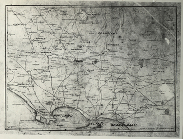
Photograph - Black and White, Map of Western Victoria
WGS 84 37" 47' S 142" 08' EPhotograph of a map showing the Grampians, Glenelg, Portland, Belfast (Port Fairy), Warrnambool, roads and land-holders.western victoria, victoria, belfast, port fairy, warrnambool, manifold -
 Flagstaff Hill Maritime Museum and Village
Document - Report, Jet Probings, Warrnambool Harbour, 16-10-1929
This report lists the depths of water and the consistency of the seabed surrounding the Warrnambool Harbour in October 1929, The information, often referred to as 'soundings', was obtained by Jet Probing,. In earlier days a lead line was used to perform a similar task. The author of the document is unknown. Jet Probing is a method used for underwater archaeology, cable installation and coastal engineering. A jet probe is a machine that produces a strong jet of water that penetrates the layers of sediment on the seabed, determining their depth, thickness and consistency. It provides a survey of the seabed and can be used as an aid to engineering design and construction. The report mentions lining up with the wooden jetty, the end of the breakwater and the leading lights. It mentions sand, loose rock and rock. It tells of stopping work due to the water being too rough, the pipe choking, difficulty in connecting pipes, and pipe joint breaking as it tried to get through the sand, The report in the document is significant for its connection with the Warrnambool Harbour, Warrnambool Breakwater, Warrnambool Jetty and Lady Bay. The report gives figures for the depth and consistency of the water and seabed at a particular point in time and can be used to compart with similar figures taken at different times. The results could determine plans for future engineering works.Report, titled 'Jet Probings, Warrnambool Harbour'. Two pages of cream coloured paper with hand written notes in pen and ink. Report covers three days of Jet Probings, with resulting figures and comments, for the depths of the surroundings of the Warrnambool Harbour. The report is in point form, with some underlining. Dates of recordings are 14-10-29, 15-10-29 and 16-10-29. (1929) The situation of the harbour had become a real problem by 1910 and required continuous dredging. In 1914 the Breakwater was extended but proved to be a failure because the work began to subside and by 1920 about two thirds of the harbour was silted up. Alterations made in the 1920's increased the silting problem. The soundings and Jet Probings were done after the Royal Commission of 1923, when the damaged stonework on the seaward side of the Warrnambool Breakwater, caused by the action of the sea, was the subject of enquiry. A conference between the Public Works, Water Commission and the Harbour Trust concluded that it would less costly to make repairs to prevent further damage rather than replaced the damage portion of the wall. A contract was raised in late 1924 to deposit rubble on the damaged side of the breakwater to minimise the Southern Ocean’s destructive action and work had started by August 1925. By the 1940's the harbour was no longer used. More alterations were made in the 1950's and 1960's. document, depth, warrnambool harbour, 1929, soundings, jet probe, jet probing, seabed, map of seabed, underwater engineering, warrnambool jetty, warrnambool breakwater, breakwater upgrade, leading lights, chart the harbour, flagstaff hill, warrnambool, flagstaff hill maritime museum & village, maritime museum, maritime village, shipwreck coast, lady bay, port of warrnambool, breakwater, jetty, pier, vhr h2024, royal commission, 1923, public works, water commission, harbour trust, victorian harbours -
 Flagstaff Hill Maritime Museum and Village
Document - Navigation Chart, Admiralty Office, Lady Bay and Warrnambool Harbour, 1893
This navigation cart of Lady Bay and Warrnambool Harbour was originally surveyed in 1870 but this version includes the update for magnetic variation in 1893. Since the printing of the chart several annotations have been added. These include an additional stamp dated 15-8-1910, a handwritten comment across the top of the page dated August 1910, and another handwritten comment regarding the ‘Proposed Extension of Dock’ dated 19-2-1925, plus connected drawings, notes and figures. The 1925 proposal on this chart may have been a reaction to the Royal Commission of 1923, when the damaged stonework on the seaward side of the Warrnambool Breakwater, caused by the action of the sea, was the subject of enquiry. A conference between the Public Works, Water Commission and the Harbour Trust concluded that it would less costly to make repairs to prevent further damage rather than replaced the damage portion of the wall. A contract was raised in late 1924 to deposit rubble on the damaged side of the breakwater to minimise the Southern Ocean’s destructive action and work had started by August 1925. The Breakwater construction had begun in 1874 and was completed in 1890. The Victorian Government had commissioned Sir John Coode, a British harbour engineer, to present a plan to complete the Warrnambool Breakwater but his original plan was too expensive. He prepared a revised plan for a shorter structure. The construction proved to be too short to protect adequately from the weather and didn't allow enough depth for larger vessels to come into port. The decreasing trade was further affected by siltation in the bay due to the breakwater, and the completion of the railway line. The situation of the harbour became a real problem by 1910 and required continuous dredging. In 1914 the Breakwater was extended but proved to be a failure because the work began to subside and by 1920 about two thirds of the harbour was silted up. Alterations made in the 1920's increased the silting problem and by the 1940's the harbour was no longer used. More alterations were made in the 1950's and 1960's. This chart is significant for its strong connection to the maritime history of Warrnambool Harbour and Lady Bay and the Warrnambool Breakwater. The Warrnambool Breakwater is registered as a place of significance on the Victorian Heritage Database (VHR H2024). The Warrnambool Breakwater is one of the most important late 19th century maritime engineering projects in Victoria and significant in the development of Victorian coastal shipping. It is also significant for its connection with British harbour engineer, Sir John Coode. The chart is a historical record of structures existing in 1893; the Warrnambool Jetties, Warrnambool Breakwater in Lady Bay, the leading lights (lighthouses), streets, roads, bridges and many buildings. It also shows the lay of the land and seabed. Navigation Chart: Lady Bay and Warrnambool Harbour, Australia - South Coast - Victoria. Surveyed by Nav. Lieut. H.J. Stanley, R.N., 1870. Updated for Magnetic Variation, 1893. The rectangular chart is printed on heavy cream paper. Stamps are shaped rectangular, oval and round. Around the Breakwater and Jetty area are handwritten notes, dotted and joined lines, numbers and signatures, and shading of red and green. The chart shows the surrounds of Warrnambool Harbour, Lady Bay, the Breakwater and Jetty, roads, bridges and the streets in Warrnambool. It has sounding details, and angles of line from the leading lights.Stamp, rectangular, including "AUG 1910" Stamp, double oval " - - - -CHART" Stamp, hand drawn, red circle, with "B" inside Hand written note "22-8-1910 - - - - - of surveying C. Ca - - - request of 15-8-10 [initials] " Notes and lines in red pen, including a grid of sounding numbers: "1300" "1050" "1200" "Possible Extension of Dock" "19-2-25" "Dock Dredged to 20 Ft" Notes and lines in blue pen "Extension of Dock to accommodate vessels drawing 20 Feet" and "Light not visible south of this line" Red dots (4) with yellow highlight at both leading lights, breakwater and jettyflagstaff hill, warrnambool, flagstaff hill maritime museum & village, maritime museum, maritime village, shipwreck coast, map, chart, navigation chart, plan, lady bay, warrnambool harbour, port of warrnambool, breakwater, jetty, pier, dock extension, proposed extension, vhr h2024, 1870, 1893, 1910, 1925, warrnambool town late 1800s, warrnambool streets late 1800s royal commission, 1923, public works, water commission, harbour trust, victorian harbours, sir jon coode -
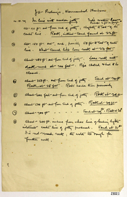
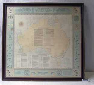 Flagstaff Hill Maritime Museum and Village
Document
1) Large map of Australia with information on explorers, navigators etc involved in its discovery. Title "The Discovery of Australia by Western Man" 2) Poster which explains in full information formulated on .1 Also gives in great detail natural history information relevant to the formation of the Australian continent.flagstaff hill, warrnambool, shipwrecked-coast, flagstaff-hill, flagstaff-hill-maritime-museum, maritime-museum, shipwreck-coast, flagstaff-hill-maritime-village -
 Flagstaff Hill Maritime Museum and Village
Book - Religious, University Press, The Holy Bible, Ca. 1850s
This Bible belonged to the Bell family. Joseph Bell was born on May 9th 1829. He married Elizabeth, who was born on October 22nd, 1833. Their marriage was conducted on September 12th, 1854, at St Pauls, Bristol, England. On the front pages of the bible there used to be a list of their ten children and their birthdates but there are only remnants of a heavy weight paper; the opposite Fly page with publication details is also missing, along with the Family Records section, which no longer has pages for Births and Marriages, only precise edges of two pages . The Bible is the King James Version, named after James Charles Stuart (1556-1625) who was King James VI of Scotland from 24 July 1567, and who was crowned King James I of England, France and Ireland from 24 March 1603 until his death in 1625. The Hampton Court Conference of 1604 commissioned a new and more accurate version of the Holy Bible that was translated from the original Sacred Scriptures and that included only the approved books. This task was undertaken be a group of learned scholars who worked in teams and compared notes, working to ensure a true and accurate version. It was completed in 1611 and became widely known as the King James Version (KJV) of the Bible and is still widely used and greatly respected for its poetic language. The first printed page of this Bible is the Translators Speech at the completed work which was handed over to King James I in 1611.This Bible was published after 1611, and likely to have been purchased at the time of the marriage of the previous owners, Joseph and Elizabeth Bell, in 1854, so it is possibly a century and a half old. The decorative cover and metal clasp are a sign that the Bible was a book to be treasured,. Indeed, our Collection included several Bibles brought to Australia by immigrants, even though luggage was tightly restricted. This Bible was once used as a family record, similar to Bibles printed in modern times, with lined blank pages in the centre for the owners to record their own, their ancestors' and their descendants' life events. Sadly, these pages are no longer within the Bible.Book, black textured leather front and back covers, gold leaf page edges, metal clasp on centre edge of front and back covers holds them together. The title is inscribed in gold embossing on the front cover. The Bible has coloured illustrations, cross references and maps. The front inside cover has remnants of a previous stuck-down page, the Fly page, and the Family Records pages for Births and Marriages has been cut out of the book. TITLE: The Holy Bible. PRINTER: University Press, London, England PREVIOUS OWNERS; Joseph and Elizabeth Bell, married in Bristol, England in 1854.Embossed in gold on cover: "HOLY BIBLE"warrnambool, shipwreck coast, flagstaff hill, flagstaff hill maritime museum, flagstaff hill maritime village, religious book, bible, holy bible, king james bible, king james vi, king james i, 1611, kjv, joseph bell, elizabeth bell, st paul's church bristol, 1829, 1833, 1854, authorised king james version, authorised version, av, sacred scriptures -
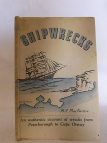 Flagstaff Hill Maritime Museum and Village
Book, Shipwrecks
Margaret MacKenzie had first hand knowledge of many shipwrecks along Victoria's treacherous 'shipwreck' coast. In her later years her failing sight caused her to attend the nearby eye specialist Dr W.R. Angus in Warrnambool. Dr Angus designed the cover for Margate's book. Margaret's daughter assisted in the writing due to her mother's failing sight.Shipwrecks by M.E. MacKenzie, part of the W.R. Angus Collection. An authentic account of wrecks from Peterborough to Cape Otway, Victoria. Cover printed in blue, black and white, depicts sailing ship approaching cliffs, and a map of the coast of south west Victoria, showing Peterborough and Cape Otway. Art work for cover was done by Dr. W.R. Angusflagstaff hill, warrnambool, shipwrecked-coast, flagstaff-hill, flagstaff-hill-maritime-museum, maritime-museum, shipwreck-coast, flagstaff-hill-maritime-village, shipwrecks, m e mackenzie, peterborough, cape otway, shipwreck coast, book, w.r. angus -
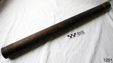 Flagstaff Hill Maritime Museum and Village
Container - Chart Case, ca 19th century
Black painted metal cylindrical container. Label attached at one end with inscription. "Flagstaff Hill c/ J Lindsay"This chart case is an example of maritime chart storage used in colonial times to protect charts and maps from the weather and to store them is an easily accessible was. Chart case, black painted metal cylindrical container with caps on both ends.flagstaff hill, warrnambool, shipwrecked-coast, flagstaff-hill, flagstaff-hill-maritime-museum, maritime-museum, shipwreck-coast, flagstaff-hill-maritime-village, chart case, navigation, chart storage -
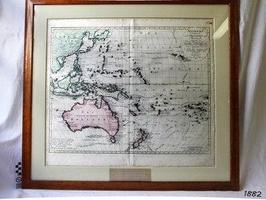 Flagstaff Hill Maritime Museum and Village
Map, Australien (Sudland) auch Polynesien oder Inselwelt, insgemein der funfte Welltheil, c.1990
This map is a reprint of Johann (Johannes) Walch’s “Australien (Sudland) auch Polynesien oder Inselwelt, insgemein der funfte Welltheil”, published in 1802. It shows Australia, New Zealand, South East Asia and the Pacific Islands shows a large number of places names, many of which have changed since the map was drawn. The map includes the routes and dates of the voyages of Tasman, Cook, Bougainville, Carteret, Byron, and others up to 1802. The shapes of the lands on this early map show that some of the areas had not yet been charted. The map was donated to Flagstaff Hill Maritime Village in April 1990 by the Group Study Exchange Team from Rotary District 233, Sweden. It was framed and presented by Rotary District 978 and presented by Barry Lange, the Governor of District 978 in 1989-90. (District 978, Geelong East, is now District 9780.) Johann (Johannes) Walch Johann Walch, painter and engraver, was born in 1757. He was well known for creating miniature portraits. He gained his training in Geneva, Venice and Rome. His publications include atlases and sheet maps, many of which were reprinted after his death in 1816. This reprint of an 1802 is significant for its historical and geographical contant, showing the voyages of many early explorers to the southern regions of the world including Australia. It also shows the early names used for countries and towns and is a valuable reference to historical interpretation. The map itself is a fine example of hand drawn and hand coloured maps of the early 19th century, the method of production, detail included, layout, symbols and so forth.Map, reprint of Johann (Johannes) Walch’s “Australien (Sudland) auch Polynesien oder Inselwelt, insgemein der funfte Welltheil “, first published by in Ausburg in 1802. The image on this Map No 5B, shows Australia and the south Pacific. The timber framed, glass covered, printed and coloured map was created in two sections and joined. Brass plaque at base of map states that the map was presented to Flagstaff Hill by Rotary International in April 1990. Feint lines used for aligning lettering can be seen on the map and there are large erased letters such as a “D” and “S” that are almost obscured.Plague “ROTARY INTERNATIONAL / THE MAP WAS DONATED BY THE GROUP STUDY EXCHANGE TEAM / FROM ROTARY DISTRICT 233 SWEDEN IN APRIL 1990 / AND WAS FRAMED AND PRESENTED BY ROTARY DISTRICT 978 / BARRY LANGE – GOVERNOR DISTRICT 978 1989/90” Stamped on back “ELLIMINOOK FRAMES / MRS. JILL FALKINER / ELLIMINOOK / BIRREGURRA, VIC. 3242 / PHONE: (052) 36 2080” flagstaff hill, warrnambool, shipwrecked coast, flagstaff hill maritime museum, maritime museum, shipwreck coast, flagstaff hill maritime village, great ocean road, australien (sudland) auch polynesien oder inselwelt, insgemein der funfte welltheil, johann (johannes) walch, cartographer johann (johannes) walch, ausburg publisher johann (johannes) walch, johann (johannes) walch map number 5b, 1802 map of australia and south pacific, rotary international group study exchange team, rotary district 233 sweden, elliminook frames, voyages of tasman, voyages of cook, voyages of bougainville, voyages of carteret, voyages of byron, barry lange, painter of miniature portraits johann (johannes) walch -
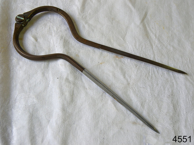 Flagstaff Hill Maritime Museum and Village
Dividers, Early 20th Century
Dividers are used by navigators to measure the distance between two points on a map or chart. Each point of the divider is places on a map point, then the distance between the points of the divider is measured against the scale of the chart or map. This helps determine the ship's path of travel, the distance travelled and the current location.Not very significant as not associated with any historical event or person, same pattern of dividers is available today from many retail outlets. Also item was probably made around 1940s to 1950sDividers; brass navigator's dividers with fine, stainless steel points. Made in Britain by W & H C (inscription). This navigational tool is used by a ship's navigator to mark the ship's position. Each end point of the divider is placed on a position on a chart or map, then the length between the points of the divider is measured on the chart's scale.Inscribed "British Made" and "W & H C". flagstaff hill, warrnambool, shipwrecked-coast, flagstaff-hill, flagstaff-hill-maritime-museum, maritime-museum, shipwreck-coast, flagstaff-hill-maritime-village, navigational dividers, navigational tool, dividers made by w & hc, w & hc britain -
 Federation University Historical Collection
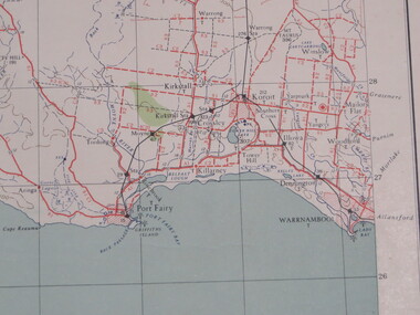
Map, Portland, 1941, 1941
Printed colour map on paperportland, port fairy, warrnambool, kirkstall, crossley, koroit, tower hill, woolsthorp -
 Flagstaff Hill Maritime Museum and Village
Book, The Logbooks of The Lady Nelson, 1915
This hardcover book, The logbooks of the 'Lady Nelson' : with the journal of her first commander, Lieutenant James Grant, R.N., by Ida Lee (Mrs Charles Bruce Marriott) was published over 100 years after the Lady Nelson arrived in Australia to navigate and survey this ‘new colony’. Included in the book are sixteen charts and illustrations from the originals in the Admiralty Library, showing the surveyed land and water. The transcribed Contents, below, summarise the trips of the Lady Nelson during this time. Book’s Content PLUS text of the Chart of ‘Part of Bass Strait’ - Chapter 1: The Lady Nelson built with centreboards. Her voyage to Sydney under James Grant. The first ship to pass through Bass Strait. - Chapter 2: Returns to explore the Strait. Her visits to Jervis Bay and to Western Port in 1801 - Chapter 3: Colonel Paterson and Lieutenant Grant survey Hunter River - Chapter 4: Murray appointed commander of the Lady Nelson. His voyage to Norfolk Island. - Chapter 5: Murray’s exploration of Bass Strait. - Chapter 6: Discovery of Port Phillip. - Chapter 7: The Lady Nelson in company with HMS Investigator examines the North-Eastern shores of Australia. - Chapter 8: The French ships in Bass Strait. The founding of Hobart. - Chapter 9: Symons succeeds Curtoys as commander of the Lady Nelson. His voyages to Tasmania, Port Phillip and New Zealand. - Chapter 10: The Lady Nelson in Tasmania. The founding of Port Dalrymple. - Chapter 11: The Estramina is brought to Sydney. The Lady Nelson visits Norfolk Island and Port Dalrymple. - Chapter 12: Tippahee and his four sons are conveyed to New Zealand in the Lady Nelson. - Chapter 13: The Lady Nelson accompanies HMS Tamar to Melville Island. - Chapter 14: The loss of the Lady Nelson Text included with the ‘Chart of Bass Strait’ … “Part of Bass Strait, including the discoveries made by Acting Lieut. J. Murray, commander of His Majesty’s armed surveying vessel Lady Nelson, between November 1801 and March 1802. By command of His Excellency Governor King.” “This chart, which bears Murray’s autograph, shows his explorations of Western Port, Port Phillip and King Island. It should be noted that Flinders Island is named Grand Capuchin. This is one of the charts referred to as "unfortunately missing” in the Historical Records of N.S. Wales, vol. iv. P. 764” The story of the Lady Nelson In 1798 the British Admiralty ordered a cutter of 60 tons to be built along the design of the armed cutter Trial that was developed by Captain John Schanck, with three sliding keels or centreboards that could be individually raised and lowered, for use on the River Thames. The new cutter was to be named Lady Nelson. Philip Gidley King, prior to taking up his appointment as third Governor of the colony of New South Wales, was in England at the time of the Lady Nelson’s fit-out and was aware of the need for such a ship for survey work in the colony in New South Wales. He convinced Captain Schanck, the Commissioner of Transport in England, to construct and rig the Lady Nelson as a brig rather than a cutter, keeping the feature of the three sliding keels, which would be very useful for mapping in shallow waters. The new Lady Nelson was launched at Deptford, England on the River Thames in November 1798, with the official commission to discover and survey the unknown parts of the coast of New Holland (Australia) and establish British sovereignty over the continent. The Lady Nelson sailed from Portsmouth, England on March 1800 under the command of Lieutenant James Grant. She carried an armament of two original and four extra brass carronade carriage guns and set sail as part of a convoy heading to Port Jackson, in New South Wales, New Holland. After a while she continued to sail on her own. Her journey was troubled with problems at times; damaged and broken keels, troublesome crew and leaking topsides between the waterline and the deck due to poor seals. She arrived at the Cape of Good Hope in July and waited for the winter to pass to avoid the strong winds of the ‘Roaring Forties’. While at the Cape, Grant received a despatch to travel to Port Jackson via the newly discovered Bass Strait, rather than the usual route via the tip of Van Diemen’s Land (Tasmania). This also gave him the opportunity to survey the strait on the way. He departed the Cape in October and in December he made his first sighting of New Holland near Mount Gambier in what is now South Australia. A report by Ecclestone in 2012, ‘The Early Charting of Victoria’s Coastline’, mentions that Grant charted and named Capes Banks and Northumberland, and sighted inland hills that he named Mt Gambier and Mt Schanck, the latter after the designer of his ship. Grant then reached the south-western shores of what is now Victoria on 3-4 December 1800, and from Cape Bridgewater he examined the coast eastward to Cape Patton. Although he had not continuously sighted the coast in the vicinity of Port Fairy and Warrnambool, the western part of Victoria became known as Grant’s Land. The Lady Nelson continued eastward and passed through Bass Strait, becoming the first vessel to reach the east coast of New Holland from the west, and arrived at her destination of Port Jackson later in December 1800. Grant, in the Lady Nelson, then left Port Jackson and began survey work. He discovered Port Phillip on Victoria’s coast and explored King Island, he helped establish the first European settlement in Tasmania on the Derwent River, and Port Dalrymple, Newcastle and Port Macquarie. He made several trips from Norfolk Island to Hobart Town. Governor Macquarie sailed on with him to Van Diemen’s Land for a tour of inspection in 1811. Grant helped establish the first settlement on Melville Island in Northern Australia. The Lady Nelson was used to transport cargo, civilians and convicts and to source pigs from Timor. In February 1825 the Lady Nelson sailed again for Timor and never returned. One report said that “Every soul on board, we regret to state, was cruelly massacred, and the hull of the vessel was seen some time after with the name painted on her stern.” The hull was sighted on the island of Babar, which is almost 200 kilometres east of Timor. This particular copy of the book ... This item is from the ‘Pattison Collection’, a collection of books and records that was originally owned by the Warrnambool Mechanics’ Institute, which was founded in Warrnambool in 1853. By 1886 the Warrnambool Mechanics’ Institute (WMI) had grown to have a Library, Museum and Fine Arts Gallery, with a collection of “… choice productions of art, and valuable specimens in almost every branch and many wonderful national curiosities are now to be seen there, including historic relics of the town and district.” It later included a School of Design. Although it was very well patronised, the lack of financial support led the WMI in 1911 to ask the City Council to take it over. In 1935 Ralph Pattison was appointed as City Librarian to establish and organise the Warrnambool Library as it was then called. When the WMI building was pulled down in 1963 a new civic building was erected on the site and the new Warrnambool Library, on behalf of the City Council, took over all the holdings of the WMI. At this time some of the items were separated and identified as the ‘Pattison Collection’, named after Ralph Pattison. Eventually the components of the WMI were distributed from the Warrnambool Library to various places, including the Art Gallery, Historical Society and Flagstaff Hill. Later some were even distributed to other regional branches of Corangamite Regional Library and passed to and fro. It is difficult now to trace just where all of the items have ended up. The books at Flagstaff Hill Maritime Village generally display stamps and markings from Pattison as well as a variety of other institutions including the Mechanics’ Institute itself. RALPH ERIC PATTISON Ralph Eric Pattison was born in Rockhampton, Queensland, in 1891. He married Maude Swan from Warrnambool in 1920 and they set up home in Warrnambool. In 1935 Pattison accepted a position as City Librarian for the Warrnambool City Council. His huge challenge was to make a functional library within two rooms of the Mechanics’ Institute. He tirelessly cleaned, cleared and sorted a disarrayed collection of old books, jars of preserved specimens and other items reserved for exhibition in the city’s museum. He developed and updated the library with a wide variety of books for all tastes, including reference books for students; a difficult task to fulfil during the years following the Depression. He converted all of the lower area of the building into a library, reference room and reading room for members and the public. The books were sorted and stored using a cataloguing and card index system that he had developed himself. He also prepared the upper floor of the building and established the Art Gallery and later the Museum, a place to exhibit the many old relics that had been stored for years for this purpose. One of the treasures he found was a beautiful ancient clock, which he repaired, restored and enjoyed using in his office during the years of his service there. Ralph Pattison was described as “a meticulous gentleman whose punctuality, floorless courtesy and distinctive neat dress were hallmarks of his character, and ‘his’ clock controlled his daily routine, and his opening and closing of the library’s large heavy doors to the minute.” Pattison took leave during 1942 to 1945 to serve in the Royal Australian Navy, Volunteer Reserve as Lieutenant. A few years later he converted one of the Museum’s rooms into a Children’s Library, stocking it with suitable books for the younger generation. This was an instant success. In the 1950’s he had the honour of being appointed to the Victorian Library Board and received more inspiration from the monthly conferences in Melbourne. He was sadly retired in 1959 after over 23 years of service, due to the fact that he had gone over the working age of council officers. However he continued to take a very keen interest in the continual development of the Library until his death in 1969 This book about the logbooks of the Lady Nelson is locally significant for its association with the brig Lady Nelson, in which Lt. James Grant made the first documented European discovery of the area later known as Warrnambool in December 1800. This book is also nationally significant for its association with Grant in the Lady Nelson being the first to sail from west to east through Bass Strait, opening up a shorter, faster route to the colony of Port Jackson rather than going all the way south around Van Diemen’s Land. The book is nationally significant for its contents of the logbooks of the journeys of the Lady Nelson under various commanders and the copies of the charts created from the surveyed information and the new land of Australia was discovered. This book is also significant for its association with the full-size non-sailing replica of the Lady Nelson from Mount Gambier’s visitor centre, which was restored by Flagstaff Hill’s Master Boat Builder in Warrnambool in 2012, and with a ship mode of the Lady Nelson in our Collection The Pattison Collection, along with other items at Flagstaff Hill Maritime Village, was originally part of the Warrnambool Mechanics' Institute’s collection. The Warrnambool Mechanics’ Institute Collection is primarily significant in its totality, rather than for the individual objects it contains. Its contents are highly representative of the development of Mechanics' Institute libraries across Australia, particularly Victoria. A diversity of publications and themes has been amassed, and these provide clues to our understanding of the nature of and changes in the reading habits of Victorians from the 1850s to the middle of the 20th century. The collection also highlights the Warrnambool community’s commitment to the Mechanics’ Institute, reading, literacy and learning in the regions, and proves that access to knowledge was not impeded by distance. These items help to provide a more complete picture of our community’s ideals and aspirations. The Warrnambool Mechanics Institute book collection has historical and social significance for its strong association with the Mechanics Institute movement and the important role it played in the intellectual, cultural and social development of people throughout the latter part of the nineteenth century and the early twentieth century. The collection of books is a rare example of an early lending library and its significance is enhanced by the survival of an original collection of many volumes. The Warrnambool Mechanics' Institute’s publication collection is of both local and state significance. The Logbooks of The Lady Nelson Author: Ida Lee ( Mrs Charles Bruce Marriott) Publisher: Grafton & Co Date: 1915Label on spine with typed text RA 910.994 LEE Inside front cover has a sticker that reads Warrnambool Mechanics Institute and Free Library shipwrecked-coast, flagstaff-hill, warrnambool, flagstaff-hill-maritime-museum, maritime-museum, shipwreck-coast, flagstaff-hill-maritime-village, shipwrecked-artefact, book, warrnambool library, warrnambool mechanics’ institute, warrnambool city librarian, mechanics’ institute library, victorian library board, warrnambool books and records, warrnambool children’s library, great ocean road, the logbooks of the lady nelson, ida lee, mrs charles bruce marriott, captain john schanck, sliding keels or centreboards, lady nelson, british brig hms lady nelson, lieutennant james grant, bass strait discovery, surveying king island and port phillip bay, philip gidley king, survey map -
 Flagstaff Hill Maritime Museum and Village
Book, The Outline of History Vol 2
This item is from the ‘Pattison Collection’, a collection of books and records that was originally owned by the Warrnambool Mechanics’ Institute, which was founded in Warrnambool in 1853. By 1886 the Warrnambool Mechanics’ Institute (WMI) had grown to have a Library, Museum and Fine Arts Gallery, with a collection of “… choice productions of art, and valuable specimens in almost every branch and many wonderful national curiosities are now to be seen there, including historic relics of the town and district.” It later included a School of Design. Although it was very well patronised, the lack of financial support led the WMI in 1911 to ask the City Council to take it over. In 1935 Ralph Pattison was appointed as City Librarian to establish and organise the Warrnambool Library as it was then called. When the WMI building was pulled down in 1963 a new civic building was erected on the site and the new Warrnambool Library, on behalf of the City Council, took over all the holdings of the WMI. At this time some of the items were separated and identified as the ‘Pattison Collection’, named after Ralph Pattison. Eventually the components of the WMI were distributed from the Warrnambool Library to various places, including the Art Gallery, Historical Society and Flagstaff Hill. Later some were even distributed to other regional branches of Corangamite Regional Library and passed to and fro. It is difficult now to trace just where all of the items have ended up. The books at Flagstaff Hill Maritime Village generally display stamps and markings from Pattison as well as a variety of other institutions including the Mechanics’ Institute itself. RALPH ERIC PATTISON Ralph Eric Pattison was born in Rockhampton, Queensland, in 1891. He married Maude Swan from Warrnambool in 1920 and they set up home in Warrnambool. In 1935 Pattison accepted a position as City Librarian for the Warrnambool City Council. His huge challenge was to make a functional library within two rooms of the Mechanics’ Institute. He tirelessly cleaned, cleared and sorted a disarrayed collection of old books, jars of preserved specimens and other items reserved for exhibition in the city’s museum. He developed and updated the library with a wide variety of books for all tastes, including reference books for students; a difficult task to fulfil during the years following the Depression. He converted all of the lower area of the building into a library, reference room and reading room for members and the public. The books were sorted and stored using a cataloguing and card index system that he had developed himself. He also prepared the upper floor of the building and established the Art Gallery and later the Museum, a place to exhibit the many old relics that had been stored for years for this purpose. One of the treasures he found was a beautiful ancient clock, which he repaired, restored and enjoyed using in his office during the years of his service there. Ralph Pattison was described as “a meticulous gentleman whose punctuality, floorless courtesy and distinctive neat dress were hallmarks of his character, and ‘his’ clock controlled his daily routine, and his opening and closing of the library’s large heavy doors to the minute.” Pattison took leave during 1942 to 1942 to serve in the Royal Australian Navy, Volunteer Reserve as Lieutenant. A few years later he converted one of the Museum’s rooms into a Children’s Library, stocking it with suitable books for the younger generation. This was an instant success. In the 1950’s he had the honour of being appointed to the Victorian Library Board and received more inspiration from the monthly conferences in Melbourne. He was sadly retired in 1959 after over 23 years of service, due to the fact that he had gone over the working age of council officers. However he continued to take a very keen interest in the continual development of the Library until his death in 1969. The Pattison Collection, along with other items at Flagstaff Hill Maritime Village, was originally part of the Warrnambool Mechanics' Institute’s collection. The Warrnambool Mechanics’ Institute Collection is primarily significant in its totality, rather than for the individual objects it contains. Its contents are highly representative of the development of Mechanics' Institute libraries across Australia, particularly Victoria. A diversity of publications and themes has been amassed, and these provide clues to our understanding of the nature of and changes in the reading habits of Victorians from the 1850s to the middle of the 20th century. The collection also highlights the Warrnambool community’s commitment to the Mechanics’ Institute, reading, literacy and learning in the regions, and proves that access to knowledge was not impeded by distance. These items help to provide a more complete picture of our community’s ideals and aspirations. The Warrnambool Mechanics Institute book collection has historical and social significance for its strong association with the Mechanics Institute movement and the important role it played in the intellectual, cultural and social development of people throughout the latter part of the nineteenth century and the early twentieth century. The collection of books is a rare example of an early lending library and its significance is enhanced by the survival of an original collection of many volumes. The Warrnambool Mechanics' Institute’s publication collection is of both local and state significance. The Outline of History Vol 2 Being a Plain History of Life and Mankind Author: H G Wells, with Maps & Plans by J F Horrabin Publisher: The Waverley Book Co Ltd Date: 1925 Label on spine with typed text PAT F 909 WEL Pastedown front endpaper has sticker from Warrnambool Public Library covered by a sticker from Corangamite Regional Library Service Front loose endpaper has a stamp from Corangamite Regional Library Service Fly paper has a stamp from Warrnambool Mechanics Institutewarrnambool, shipwrecked-coast, flagstaff-hill, flagstaff-hill-maritime-museum, maritime-museum, shipwreck-coast, flagstaff-hill-maritime-village, shipwrecked-artefact, book, pattison collection, warrnambool library, warrnambool mechanics’ institute, ralph eric pattison, warrnambool city librarian, mechanics’ institute library, victorian library board, warrnambool books and records, warrnambool children’s library, the outline of history, h g wells -
 Flagstaff Hill Maritime Museum and Village
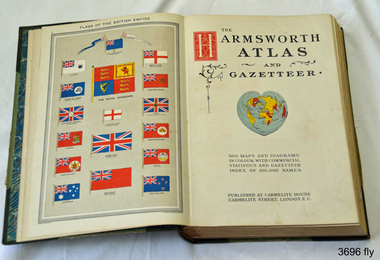
Book, Harmsworth Atlas and Gazetteer, 1908
This Harmsworth Atlas and Gazetteer was inherited by one of the donors, a gift from her father who was Tasmanian.Large hard covered book with maps, charts and tables. The cover is green linen with green leather, gilt trimmed corners and decorative spine, It includes 500 maps and diagrams in colour, with commercial statistics and gazetteer index of 105,000 names. Jan 1908. Also inserted between the pages of the book were 2 folded sheets of waxed paper, each with carefully placed flowers pressed between them; native orchids and wattle. Published at Carmelite House, Carmelite Road, London flagstaff hill, warrnambool, shipwrecked coast, flagstaff hill maritime museum, maritime museum, shipwreck coast, flagstaff hill maritime village, great ocean road, harmsworth atlas and gazetteer, atlas 1908, maps 1908, gazetteer 1908, book 1908, pressed australian native flowers, pressed wattle, pressed orchid