Showing 345 items
matching water tanks
-
 Southern Sherbrooke Historical Society Inc.
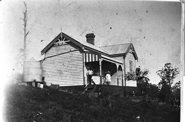
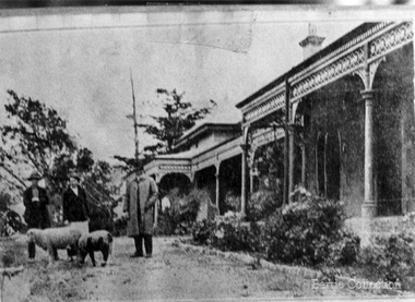
Photograph - Glen Park Homestead, Percy and Cissy Johns on verandah, early 1900s
... chimney where the two wings meet, and a metal water tank... where the two wings meet, and a metal water tank to the side ...B&W photo shows siblings Percy and Cissie (Minnie Agnes) Johns on the verandah of their home, Glen Park Farm, Selby. Percy looks in his early teens, making the photo around 1910 or later. He is wearing a long-sleeved pale shirt, long dark trousers tucked into knee-high boots, and possibly a dark hat. Cissie is wearing a pale, knee-length dress, dark stockings, and a pale, wide-brimmed hat. She is aged about 10. A medium sized dark dog sits at Percy's feet. The house is an L-shaped weatherboard with two gables at right-angles and a verandah with a bullnosed roof, ornate support posts, and a striped end piece from the roof. Wooden steps lead down from side. There is a large brick chimney where the two wings meet, and a metal water tank to the side. There are large trees, both in leaf and dead, plus some flowers near the verandah. -
 Bendigo Historical Society Inc.
Photograph - PHOTOGRAPH. WATER TREATMENT PLANT IN BENDIGO
... , written on front of tank, 'Water Treatment. Frank A. Stevenson... PHOTOGRAPH Tank water treatment Photograph. Water Treatment Plant ...Sepia photograph - water treatment plant, Bendigo. Picture of a tank laying on it's side, at the front has 8 turning wheels, written on front of tank, 'Water Treatment. Frank A. Stevenson, Bendigo.' Picture has lots of pipes and taps at the rear of the tank.photograph, tank, water treatment, photograph. water treatment plant, bendigo. frank a.stevenson. -
 Bendigo Historical Society Inc.
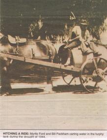
Newspaper - JENNY FOLEY COLLECTION: HITCHING A RIDE
... a ride: Myrtle Ford and Bill Packham carting water in the furphy...: Myrtle Ford and Bill Packham carting water in the furphy tank ...BHS CollectionBendigo Advertiser ''The way we were'' from 2002. Hitching a ride: Myrtle Ford and Bill Packham carting water in the furphy tank during the drought of 1944. The clip is in a folder.newspaper, bendigo advertiser, the way we were -
 Bendigo Historical Society Inc.
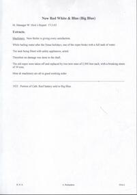
Document - NEW RED WHITE & BLUE MINE - NEW RED WHITE & NEW CHUM RAILWAY MINE MANAGER'S REPORT 17/2/03
... of the ropes broke with a full tank of water. The tank being fitted..., one of the ropes broke with a full tank of water. The tank ...Handwritten extracts and typed copies of same, from the New Chum Railway Mine Manager's Report 17/2/03. Mine Manager W Hicks. Extracts: Machinery. New Boiler is giving every satisfaction. While bailing water after the Xmas holidays, one of the ropes broke with a full tank of water. The tank being fitted with safety appliances, acted. Therefore no damage was done to the shaft. The old ropes were taken off and replaced by two new ones of 2,500 feet each, with a breaking strain of 34 tons. Mine 7 machinery are all in good working order. 1925 - Portion of Cath. Reef battery sold to Big Blue. Albert Richardson Collectiondocument, gold, new red white & blue mine, new red white & blue mine, new red white & blue mine manager's report 17/2/03, w hicks, cath reef battery -
 Eltham District Historical Society Inc
Photograph, Demolition of water tower at 51 Cassells Road, Research, 6 April 2017, 6/4/2017
... "The water storage tank (the ‘golf ball’ tower) was located... melbourne "The water storage tank (the ‘golf ball’ tower ..."The water storage tank (the ‘golf ball’ tower) was located in Cassells Road, and for many years it played an important role in supplying the Research and Eltham communities with drinking water. However, due to prior upgrades of water supply infrastructure in the area, these communities are receiving their water supply in a more reliable way. The storage tank was no longer operating and as it no longer served a purpose, the time had come for it to be removed. Decommissioning works occurred between November 2016 and January 2017, and the tower was removed in March 2017." Source: Yarra Valley Water Eltham Water Project onlineDigital files only (17 jpg and one two second MP4 files)cassells road, demolition, research (vic.), water tower -
 Melbourne Water
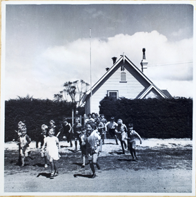
Photograph, North Cocoroc State Primary School, 1950s
... water tank. ... water tank. This photograph detailing an exterior view ...As the Yarra became unsuitable as a source of water, several attempts were made to find alternative sources for the growing population of Melbourne. It was not until 1891 that the efforts to sewer Melbourne came to fruition with the setting up of the Melbourne Metropolitan Board of Works (MMBW), now known as Melbourne Water. From 1891 until 1992, it was the responsibility of the MMBW to safeguard public health by providing a sewerage system and a safe water supply system. In 1992, The MMBW merged with a number of smaller urban water authorities to form Melbourne Water. The township of Cocoroc was created in 1894 at the Metropolitan Sewage Farm (now the Western Treatment Plant) to house the workers it employed. The name 'Cocoroc' means 'frog' in the language of the Wathaurung people — the Traditional Owners of the land the treatment plant was built on. By the early 1950s there were nearly 100 houses, a town hall, football ground (and team), swimming pool, tennis courts, four schools and a post office, and by the 1970s some 500 people were living in Cocoroc. As it became too expensive for the MMBW to subsidise, Cocoroc was abandoned. By 1973 most of the houses and other buildings were demolished or moved to Werribee. All that is left now of Cocoroc are two small, empty, concrete swimming pools, a few weatherboard sheds and a big iron water tank. This photograph detailing an exterior view of the North Cocoroc State Primary School, is historically significant as it captures children at play within a purpose built community. The School that was one of four was built to educate the children of the MMBW workers. As the school no longer exists, this photograph is the only tangible evidence left of the building, also showcasing the style of buildings in this era. cocoroc, township, school, mmbw, melbourne metropolitan board of works, melbourne water -
 Royal District Nursing Service (now known as Bolton Clarke)
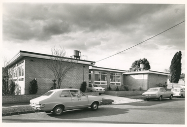
Photograph - Digital image, Barry Sutton, 12.07.1972
... windows are seen in the centre section. A small water tank... water tank and piping sit on a platform on the roof of both ...The photograph is taken outside the new Royal District Nursing Service (RDNS) Caulfield Centre. RDNS Sisters left in RDNS Torana vehicles from this Centre each morning to give nursing care to patients in surrounding suburbs and returned to the Centre after their visits. Gradually over the years, Melbourne District Nursing Service (MDNS), later known as Royal District Nursing Service (RDNS) from 1966 when they received Royal patronage, opened Centres throughout the Melbourne Metropolitan area and outer suburbs. In 1972 The Melbourne Centre which was conducted from RDNS Headquarters, 452 St. Kilda Road, was relocated to Caulfield and it became the Caulfield Centre. Their Trained nurses (Sisters) left from these Centres each morning to carry out their nursing visits in a specific area (district), taking any sterilized equipment needed with them. They returned at the end of the day to write up their patients nursing histories, clean and reset any equipment used ready for re-sterilization, and contact other medical and community personal as necessary. Most of the RDNS cars were housed at each Centre, only a few being driven home by a Sister. This is a black and white photograph of two RDNS two door grey Torana cars parked on the road outside a flat roof, one storey, light coloured brick building. The building is in three sections with the centre section set back. Part of the back of a white car can be seen in the driveway to the left of the set back section. Three large white framed windows can be seen along the end view of the left hand section and even larger windows are seen in the centre section. A small water tank and piping sit on a platform on the roof of both the left and right hand sections of the building. White fascia with dark trim above it edges the roof on each sections of the building. Some pencil shape type shrubs and a bare tree is seen in front of the building and a low light coloured brick fence runs across the property and down either side of the drive, with the footpath and nature strip in front of this. The back of a white car is seen on the road in the far right of the photograph and part of a wooden fence and parts of two large trees with leaves can be seen.Barry Sutton Photographer's Stamp. Quote KY 5rdns, royal district nursing service, rdns transport, rdns centre -
 Eltham District Historical Society Inc
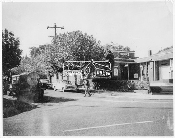
Negative - Photograph, Ian McDonald, Corner of Main Road and Arthur Street, Eltham, 4 Jan. 1968
... as the Plaza Theatre from 1943 to about 1968. A truck with a water tank... as the Plaza Theatre from 1943 to about 1968. A truck with a water tank ...The intersection of Arthur Street and Main Road Eltham, January 4, 1968. The Eltham Shire Council hall and offices on the right hand side. The Hall was also a cinema and operated as the Plaza Theatre from 1943 to about 1968. A truck with a water tank is on the left of the street, possibly cleaning the street. Note Cinema sign on hall. Copied from an original document produced by Ian McDonald (Eltham Shire Council) 1970. During the period 1969-1971 photos were being collected for a proposed publication on the history of the Shire of Eltham as part of its centenary celebrations in 1971 (managed by the Shire of Eltham Historical Society and Alan Marshall). The publication was Pioneers & Painters (1971), edited by Alan Marshall. The document titled "Shows area sold to Woolworths" consisted of a panorama of three B&W photo prints creating a panorama of the frontage along Main Road (SEPP_0744) and a single B&W photo print of the Shire of Eltham offices and Hall on the corner of Arthur Street and Main Road (SEPP_0737) along with typed and hand written notes by Ian McDonald. The panorama (SEPP_0744) was captioned in typewritten text "Old Shire Office and Hall, etc - Frontage of 285 feet along Main Road" and in pencil the date "4-1-68" The single image of the shire offices (SEPP_0737) was captioned in typewritten text "Main Road and Arthur Street Corner" In addition, the following handwritten notes in pencil: " I took these photos from the new fire station - the building in the middle is the old fire station - Moved to Research for the Scouts 1970" and signed "IMcD"This photo forms part of a collection of photographs gathered by the Shire of Eltham for their centenary project book,"Pioneers and Painters: 100 years of the Shire of Eltham" by Alan Marshall (1971). The collection of over 500 images is held in partnership between Eltham District Historical Society and Yarra Plenty Regional Library (Eltham Library) and is now formally known as 'The Shire of Eltham Pioneers Photograph Collection.' It is significant in being the first community sourced collection representing the places and people of the Shire's first one hundred years.Digital image 4 x 5 inch B&W Negsepp, shire of eltham pioneers photograph collection, eltham, arthur street, cinema, eltham hall, main road, shire hall, motion picture theartre, plaza theatre -
 Puffing Billy Railway
NGG16 No.127 - Garratt Steam Locomotive, 1951
... locomotives had welded water and coal bunkers and flat-topped water...-topped water tanks with rounded top side edges. The Beyer ...No. 127 is a 2'-gauge ex-South African Railways 'NGG16' class Beyer-Garratt locomotive. It was built by Beyer Peacock & Co of Manchester (builder's No.7428 of 1951) to their "Beyer Garratt" patented design of articulated steam locomotive. The South African Railways Class NG G16 2-6-2+2-6-2 of 1937 is a narrow gauge steam locomotive. Between 1937 and 1968, the South African Railways placed 34 Class NG G16 Garratt articulated steam locomotives with a 2-6-2+2-6-2 Double Prairie type wheel arrangement in service on the Avontuur Railway and on the Natal narrow gauge lines - The third order was for a further seven locomotives in 1951, numbered in the range from NG125 to NG131, once again from Beyer, Peacock. These and the subsequent locomotives had welded water and coal bunkers and flat-topped water tanks with rounded top side edges. The Beyer, Peacock locomotives ordered by the SAR, numbers NG109 to NG116 and NG125 to NG131, were shared more or less equally between the Natal and Avontuur lines No. 127 was purchased from the South African Railways by the Emerald Tourist Railway Board for the Puffing Billy Railway in late 2011 / early 2012, together with a container load of spare parts stripped from a derelict NGG16, and prepared for transport to Australia. The spare parts will assist in the restoration of sister NGG16 No.129 in the short term, while No.127 will provide the PBR with the option of restoring a second NGG16 at some future stage, if required. details from http://www.australiansteam.com/BP7428.htmHistoric - Overseas - South African - Narrow Gauge Railways - Steam Locomotive Garratt Steam Locomotive - 2-6-2+2-6-2 Beyer Peacock & Co NGG16 No.127 build No.7428puffing billy, ngg16, sar, beyer peacock & co garratt ngg16 no.127 build no7428, narrow gauge, steam locomotive, garratt -
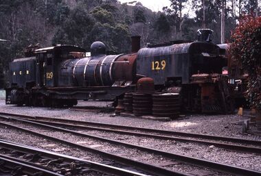 Puffing Billy Railway
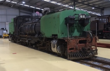
NGG16 No.129 - Garratt Steam Locomotive, 1951
... welded water and coal bunkers and flat-topped water tanks...-topped water tanks with rounded top side edges. The Beyer ...Steam Locomotive - 2-6-2 2-6-2 Beyer Peacock & Co Garratt NGG16 No.129 build No. 7430 Loco - Garratt NG129 Date acquired - 1996 Acquired from - South African Railways State when acquired - Work done - Currently being rebuilt to 2 ft 6 in (762 mm) gauge as a backup for G42. Expected Return to service in 2019. Restored to service - Current State - Currently being Rebuilt It was built by Beyer Peacock & Co of Manchester (builder's No.7430 of 1951) to their "Beyer Garratt" patented design of articulated steam locomotive. The South African Railways Class NG G16 2-6-2+2-6-2 of 1937 is a narrow gauge steam locomotive. Between 1937 and 1968, the South African Railways placed 34 Class NG G16 Garratt articulated steam locomotives with a 2-6-2+2-6-2 Double Prairie type wheel arrangement in service on the Avontuur Railway and on the Natal narrow gauge lines - The third order was for a further seven locomotives in 1951, numbered in the range from NG125 to NG131, once again from Beyer, Peacock. These and the subsequent locomotives had welded water and coal bunkers and flat-topped water tanks with rounded top side edges. The Beyer, Peacock locomotives ordered by the SAR, numbers NG109 to NG116 and NG125 to NG131, were shared more or less equally between the Natal and Avontuur lines Historic - Overseas - South African - Narrow Gauge Railways - Steam LocomotiveSteam Locomotive - 2-6-2+2-6-2 Beyer Peacock & Co Garratt NGG16 No.129 build No.7430 made of steel, wrought iron and ironpuffing billy, beyer peacock, beyer peacock & co garratt ngg16 no.129 build no.7430, narrow gauge, steam locomotive, garratt locomotive, garratt ng129, garratt ngg16 no.129 -
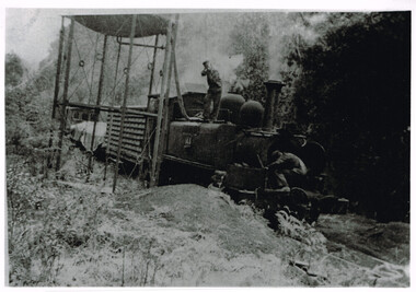 Otway Districts Historical Society
Photograph, Les Ogden, Locomotive 14A taking water at 10 mile tank, 1960-61
... Locomotive 14A taking water at 10 mile tank.... mile tank in c.1960=61. The driver controlling the water is W... goods trucks taking water at 10 mile tank in c.1960=61 ...By 1960/61 all the factors operating against a narrow gauge railway were in place for the Colac-Beech Forest line. As well as using a 2-6-2 Tank engine over 60 years old, 14A, the train by this stage only had a louvre van, two NQ trucks and a guard's van to bring to Colac. It was very near the end.Locomotive 14A and a mixed goods trucks taking water at 10 mile tank in c.1960=61. The driver controlling the water is W. Brady while the fireman, Les Ogden, peers into the smoke box. B/W.colac; beech forest; ten mile creek; locomotive 14a; w. brady; l. ogden; railway; -
 Flagstaff Hill Maritime Museum and Village
Photograph - Historical, Port Fairy, Late 19th to early 20th centuries
... water tank... on the left, a corrugated water tank is positioned below a pipe joined... roof stone building picket fence water tank weatherboard ...The late 19th to early 20th century stone cottage with weatherboard extensions. From research, it has been determined that the cottage was the Port Fairy (Belfast) Lighthouse Keepers cottage. The dome roof in the background indicates a lighthouse, in which case the cottage would have been the living quarters for a lighthouse keeper and assistant keeper. The narrow poles could have been for signals and antennae. The object on the rock stack looks like a large metal milk can.The photograph shows a typical late 19th to early 20th century cottage, abandoned at dilapidated for many years. Black and white rectangular photograph mounted on card. The image shows a dilapidated stone cottage with an old picket fence. Extending behind the stone cottage are gabled roofs above weatherboard walls. The cottage has corrugated roof sheets of different colours, and four chimneys, three with chimney pots. From research, it has been determined that the cottage was the Port Fairy (Belfast) Lighthouse Keepers cottage. Near the fenceline on the left, a corrugated water tank is positioned below a pipe joined to the roof gutter. Nearby are a timber shed and timber walls or screens. In the background are two tall narrow poles with spheres on top, higher than the cottage, with one pole on each side, the left one attached to the building. A domed roof with a knob on top is on the right behind trees. Several angular shapes appear on the horizon on the left, one almost hidden by the trees. The foreground is rocky and slopes uphill on the right. At the foot of the slope is a stack of closely fitted rocks with an object shaped like a milk can on top and an object to its left that is like an open grid. Handwritten Inscriptions are on the reverse side of the photograph.Pencil on board: " D9 / 200 x 150" Pen on sticker: "52"flagstaff hill maritime museum and village, warrnambool, great ocean road, shipwreck coast, cottage, lighthouse, iron roof, stone building, picket fence, water tank, weatherboard building, 19th century cottage, early 20th century cottage, abandoned cottage, antenna, chimneys, milk can -
 University of Melbourne, Burnley Campus Archives
Photograph - Black and white print, Glen Wilson, Natives, 15 Months After Planting at Merricks, Unknown
... . Poor soil. Only tank water. 30 yrs old pine trees on this block... planting at Merricks. Poor soil. Only tank water. 30 yrs old pine ...Black and white photograph. Photograph of plants surrounded by mulch.On reverse, "Natives, 15 months after planting at Merricks. Poor soil. Only tank water. 30 yrs old pine trees on this block (removed?) 18 months before photo taken. Ground mulched with 12" sawdust. Planted by "Schubert Method."merricks, pine trees, schubert method, natrive plants, sawdust mulch -
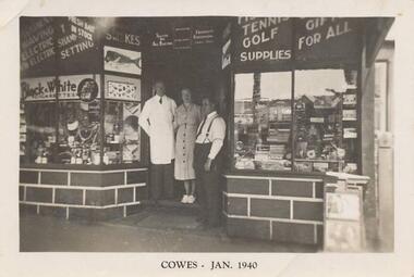 Phillip Island and District Historical Society Inc.
Photograph, 1940
... and water tanks. Photograph 215-07 Black & White photograph... and water tanks. Photograph 215-07 Black & White photograph ...Nine photographs from a collection of 33 donated by Leonie Brennan. Photographs belonged to Edward (Ted) Sands, hairdresser.Photograph 215-01 Black & White photograph of 3 people standing in front of Mr Anderson's shop in Cowes. Miss D Winson?? Mr O S Kennedy & Mr R Anderson. Photograph 215-02 Black & White photograph of landing cranes on the Cowes pier. Cowes foreshore and mature trees in background. Photograph 215-03 Black & White photograph of the early construction of Phillip Island bridge viewed from Phillip Island. Shows the base structure of the first bridge. Photograph 215-04 Black & White photograph of the Newhaven - San Remo Punt on the shore on the Phillip Island side. Photograph 215-05 Black & White photograph of Edward (Ted) Sands standing in front of R Anderson's shop in Cowes. Photograph 215-06 Black & White photograph of a koala in tree in front of shed and water tanks. Photograph 215-07 Black & White photograph of the Isle of Wight Hotel showing front footpath and shop next door. Photograph 215-08 Black & White Photograph of the Cowes beach at low tide, showing mature trees on the foreshore and boats in the water. Photograph 215-09 Black & White Photograph of Mr R Anderson's Shop in Cowes.All photographs except for one marked on front with "Cowes" the month and year 1940.cowes shop phillip island, mr anderson, mr o s kennedy, mr edward (ted) sands, isle of wight hotel phillip island, cowes pier phillip island, cowes beach phillip island, newhaven-san remo punt, wildlife - koala, koala cowes phillip island, phillip island first bridge, leonie brennan -
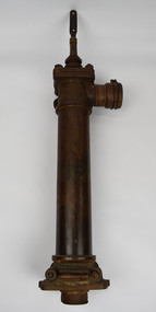 National Wool Museum
Tool - Water Pump, c.1960
... is above outlet pipe which would send water to the storage tank.... tank. Tool Water Pump ...A windmill may be considered one of the most iconic sights of Australian Farming life. A pump like this rest at the heart of all such windmills, turning wind energy into water for farmers both here in Australia and worldwide alike. The water windmills access is referred to as an aquifer, an underground layer of water trapped in rocks but accessible with use of water wells and windmills. Australia is home to an underground aquifer known as the Great Artesian Basin. It is the largest and deepest aquifer in the world. Stretching over 1,700,000 square kilometres, the Basin underlies nearly a quarter of the continent including most of Queensland, the south- east corner of the Northern Territory, the north-east part of South Australia and the northern part of New South Wales. The basin is 3,000 metres deep in places and is estimated to contain 64,900 cubic kilometres of groundwater. To try and give this number context, a megalitre is a million litres. The Great Artesian Basin contains 65,000 million megalitres of water. This would be enough to cover all the land on the planet in almost half a metre of water.Lift style piston pump typical of an Australian farm connected to a multi-bladed windmill. Bronze cylindrical construction coming up from removable wood base. Rotating lever is above outlet pipe which would send water to the storage tank.windmill, australian farming, great artesian basin, aquifer -
 Bendigo Historical Society Inc.
Photograph - HILDA HILL COLLECTION: BLACK AND WHITE PHOTOS, 1917-1924
... and white shirt, holding a skinned rabbit, water tank in background... and white shirt, holding a skinned rabbit, water tank in background ...Series of Black & White Photos Total 6 Hill Family & Friends During the First World War and after. Rita, wearing a dark dress with white collar and holding a dark coloured hat, background is large brick structure with windows to right and small section of veranda, pal tree, Railway Reserve Kyneton 1918. Man and two women wearing white dresses and dark hats, man wears dark suit white shirt and dark tie with his back against a large wheel, white sheet on ground between them and indistinguishable articles on sheet, Hibernian Picnic Axedale November 13th 1918. Group of young girls and boys all dressed in light coloured clothing gathering Botanical gardens January 1917, Miss N. Linnane reclining on cane lounge chair on verandah, weatherboard wall of house, verandah post, rock garden edging in foreground, May 1918. Monte Video Property Queensland Jeff, dressed in dark trousers and white shirt, holding a skinned rabbit, water tank in background, wire fence, July 1924. Father & Mother, Father wears a grey suit with white shirt and dark tie, Mother seated is wearing a dark dress with striped collar and white blouse, 'The Ranche' Mollison Street Eppalock.Hilda Hill Personal Collectionaustralia, history, post war life -
Bendigo Historical Society Inc.
Document - INVOICE COLLECTION: R.W.& B.L.WEEKS, 1991
... ). Charges for replacement of ball valve and float to hot water... and float to hot water and cold feed tank on roof at Dudley House ...Document. Plumbing sales and services. To Miss L.J.Parry, 107 Wills Street, Bendigo, 3550.(Bendigo Historical Society). Charges for replacement of ball valve and float to hot water and cold feed tank on roof at Dudley House, View Sreet, Bendigo. Labour, material and vehicle total: $ 109.61.document, memo, plumbing sales & service. -
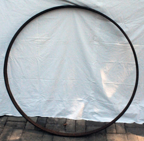 Orbost & District Historical Society
iron wheel rim
... fit as it cools after being dropped into a tank of water.... after being dropped into a tank of water. Horse-drawn wagons ...This was probably for a light buggy. Heavy farm, and lumber wagons had wider tires. It would have been made by a blacksmith. The blacksmith fitted steel rims onto wooden wagon wheels. The red hot metal rim expands when hot, so it can be fitted to the wagon wheel. Then it contracts to create a tight fit as it cools after being dropped into a tank of water.Horse-drawn wagons are an important part of Orbost’s agricultural history. Light buggies were popular with farmers for trips into town before the common use of motorised vehicles.A large iron rim for a wagon wheel.wheel-rim wagon transport agriculture -
 Eltham District Historical Society Inc
Document - Property Binder, 1184 Main Road, Eltham
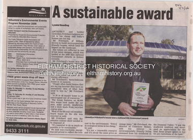
... tank. The house is water and energy self-sufficient and at 12... tank. The house is water and energy self-sufficient and at 12 ...Newspaper article: A sustainable award, Diamond Valley Leader, 1 November2006, Architect and building Llewellyn Pritchard won resource Efficiency Housing Award, finalist in HIA Greensmart Building of the Year Award. House – Environmental Leader (Published: Nillumbik Now and Then / Marguerite Marshall 2008; photographs Alan King with Marguerite Marshall.; p186) In 2006 environmental awareness was mushrooming in the community, which is reflected in the award-winning house at Main Road near Wattletree Road, Eltham. At first sight, the building appears a mix of a classic Eltham mud-brick house and an avant-garde building style. The crown of solar panels stretching along the width of the curved roof, indicates that this is no ordinary house. In fact it signals a new building trend of minimal impact on the environment. Yet it utilises the environment with high technical expertise to achieve comfort and cut running and maintenance costs. In recognition of this, its designer/builder, Conscious Homes, won the 2006 National HIA Greensmart Resource Efficiency Award. For Conscious Homes director, Llewellyn Pritchard, this house reflects a philosophy, strengthened by his connection with Aboriginal culture, through his foster siblings. Pritchard believes the sustainable way indigenous Australians lived and their spiritual connection with land, demonstrates how humanity is part of the ecology. His interest in environmental design stemmed from growing up in bushy Eltham Shire, with its mud-brick tradition. This was followed by studying Architecture at RMIT in the early 1980s, and learning about passive solar design. Pritchard says this house demonstrates that environmental sustainability is not about sacrifice, but about exceptional levels of occupant comfort, savings in running costs and modern fittings and appliances.1 The solar panels on the north roofs are intentionally obvious to make a statement about what the building is doing. But inside the systems are hidden and interactive with conventional services, such as the underground water tank. The house is water and energy self-sufficient and at 12 squares is much smaller than conventional houses, to minimise resources. Yet it accommodates his family of four with three bedrooms, a living/dining and kitchen area and a bathroom/laundry. Importantly the building is designed to last hundreds of years, by being able to be modified as the need arises, such as for commercial use. In this way the structure minimises its environmental impact. The solid double mud-brick walls (which are insulated) include steel beams and supporting frame, allowing the future removal or alteration of any section. The materials are local, recycled and of low toxicity where possible.2 Inside and out, the mud-brick is rendered and sealed with a combination of cement and sand and a mud-based coating in a soft golden hue increases its life. Inside, the golden-brown timber is plantation Mountain Ash and the concrete floors throughout – of local stone aggregate with a clear seal – have a natural looking random stone appearance. The house sustains a stable temperature of around 20 degrees, assisted by the concrete slab floor. The many large double-glazed windows and highlights (windows set high on walls) provide cross-flow ventilation. The north-facing living area maximises heating from the lower winter sun and is cooler in summer, because the sun is higher. Heating comes from a solar hydronic slab system. All appliances and fittings are high efficiency energy or water rated. Appliances in the timber kitchen include a gas stove and a dishwasher, using the building’s own power and water. French doors open from the living area to a deck, concealing the treatment system for all waste water. This is pumped through sub-soil drippers to the indigenous garden beds and no-dig vegetable patch. Below the carport is the 80,000-litre rainwater tank and at the back, the boiler room houses the solar boiler, water tank access, domestic water supply pump, filter gear and hydronic slab heating controls. The solar system is backed up with gas, which is needed to heat water only in winter. Gas used is less than one quarter of that for an average home with ducted heating. Excess power is fed back to the grid and the building uses about one quarter of the mains electricity of an average home. Other local builders have followed Pritchard’s lead in resource efficiency for minimal environmental impact.main road, eltham, businesses, llewellyn pritchard, hia greensmart building of the year award., efficiency housing award, conscious homes australia pty ltd -
 Charlton Golden Grains Museum Inc
Photograph, Brownjohn, Reg, Rear of Johnson's Bridge Store c. 2000, c.2000
... of the roof is missing and the beams are exposed. Gas tank/hot water.... Gas tank/hot water service in corner in the centre ...Derelict rear of building built as Bridge Store in 1872 for Peter Johnson, later Wylie's Building and a furniture store. Photo taken for the Museum.Colour photograph of the rear of an old, brick two storey building. Building appears derelict and disused. Not all the building is in the photo. Old rainwater tank on RH side, part of the roof is missing and the beams are exposed. Gas tank/hot water service in corner in the centre of the photo. Single door to the right of the gas tank and double doors to the left.bridge store, peter johnson, wylie's building, business -
 Warrnambool and District Historical Society Inc.
Document - Minutes Books, Woollen Mills 1909- 1923 1933-1945, C 1909 C 1933-1945
... quarried from the site and rain water tanks and asphalt floors... quarried from the site and rain water tanks and asphalt floors ...The minutes book of the Warrnambool Woollen Mill are an important record of the beginnings of one of Warrnambool's major industries for close to one hundred years. They record the struggle in the early days of 1909 and 1910 to raise the capital. Also mentioned is the support which had been given by local people of small means who were prepared to back the enterprise while those with financial means had been rather more reserved. Apart from a Mr Vidler all the initial directors were initially working in an honorary capacity. They lamented the fact that local banks held half a million pounds on fixed interest so there was no shortage of money. The first directors were appointed in March 1909 : Jas. Worland, W H Philpott, G S Mackay, E H Price, S McDonald, J C Beeching, W Rogers ,J Marfell, J Deany, Jas Duirs, Jas. Ponting, H Jessen, S Nettleton, J Blain, J Gooden, Drs. Holmes, Henderson and Powell. Mr J E Bennett was secured as first manager of the mill in 1910 Over the ten year period of this book there is much discussion on possible returns and share prices as well as decisions relating to the operation of and production from the mill. Within four years they were using more yarn than they were producing. Electricity was connected around 1914 and by 1915 shareholders were receiving eight percent return on their investment and were also contributing to the first world War effort by supplying blankets. Assets continued to accumulate and building was also continued with sandstone being quarried from the site and rain water tanks and asphalt floors installed, all contributing to savings. By 1917 The Warrnambool Woollen Mill was considered to be one of the states best investments and it continued to prosper through the years. The second minutes book likewise records similar events and circumstances for the period 1933-1945. This like wise is an interesting period, covering the period of the second World War. In 1955 the Warrnambool Woollen Mill formed a partnership with the Wangaratta Woollen Mills. Dunlop bought the mill in 1968. From that time until its closure in 2000 it had a number of different owners, the last being the Smith Family Industries. These minutes books hold an important information regarding the establishment and early operation of one of Warrnambool's major industries. The mill itself has strong connection to the Warrnambool community and many of the names mentioned as directors and shareholders have held positions within the community as businessmen and city officials. These minutes add another dimension to their contribution to Warrnambool..1Navy blue hard card cover with cloth spine. White label glued to front cover.186 pages.There are handwritten entries in black ink which are interspersed with reports from newspaper. .2 Pale grey cloth cover on early Kalamazoo filing system 612 pages of typed minutes . .1There are dates from 1910 through to 1923. Minutes have been signed by chairman of directors, M Saltau.label on front cover has blue stamp, The Warrnambool Woollen Mill Company. hand written above in black ink "opened 24th March 1909." .2 dated from May 1933 to September 1945. Signatures include M Saltau, James Disckson and Fletcher Jones.warrnambool, warrnambool woollen mill, first minutes book warrnambool woollen mill, minutes book, warrnambool woollen mill 1909, minutes book warrnambool woollen mill 1945 -
 Falls Creek Historical Society
Magazine - Fall-Line - Australia's National Skiing Magazine April '79
... . over that period. The access trail from the water tanks.... The access trail from the water tanks at the base of the Home Trail ...“Fall-Line” was one of a series of magazines published by the Victorian Ski Association. It was produced from 1979 until 1985. It superseded their previous publication, “Ski” magazine and was followed by the “Australian Skiing” magazine. The Victorian Ski Association was formed in 1955.This magazine is significant because it documents developments in the ski industry in Australia.A magazine featuring a coloured image on the cover and containing articles and advertising related to developments in skiing in Australia. This issue included an update on improvements being made at Falls Creek. FALLS CREEK The chairlift access area near the medical centre, long famous as the Mudpie Parlour of Falls Creek, has been sealed and Falls Creek itself, the waters of which have filled many an unsuspecting gum- boot, has been bridged, also near the medical centre. A lock-up storage shed will be built along Bogong High Plains Road, just below the oversnow terminal, for the use and convenience of all village commercial operators and site holders. Direct access will be possible by snowmobile. Falls Creek rates have risen to $82.50 per bed (less 10% discount if paid on time). The rise is the first in two years, and is less than the corresponding rise in the C.P.I. over that period. The access trail from the water tanks at the base of the Home Trail to the nursery slope has been smoothed and widened to 12 metres, and a new six metre wide access trail has been cut from Falls Creek Road, just behind Diana lodge to the chairlift bottom station. The Village Bowl comfort station is being extended and renovated, and the finishing touches are being put on the comfort station in the upper car park. Construction of an akja station/toilet block in Sun Valley will commence in 1980. The Management Committee is investigating the purchase of a Mercedes 800 series snow-clearing machine to supplement the CRB equipment in use in village parking areas The village water supply has been re- designed to ensure adequate supply at all times.australian ski magazines, skiing australia, victorian ski association -
 Melbourne Tram Museum
Photograph - Black & White Photograph/s, c1926
... . You can just make out the word " ….field" etc … on the water... out the word " ….field" etc … on the water tank . The sign ...Black and white photograph of the construction of the tram track in St Kilda Road, during 1925 or 1926 by the Foundation Construction Ltd, with a concrete mixer tracked vehicle and two aggregate or crushed rock trucks. Photo from the Collection of the Department of Infrastructure now with the Public Records Office - image number H514. Note: this photo is now out of copyright and was not an original VR photograph, but one copied from another source and collected as their Heritage series. See Image 3674i2 and 3674i3 for a digital image of the card photograph at the PRO on 7/1/2019 that this photograph comes from. Further notes from Rod Atkins 11/7/2019: The cement mixer was state of the art machine at the time. "Buddy" in the USA were making them but this one is slightly different and may have been made by a company call AAC in Sheffield U.K. You can just make out the word " ….field" etc … on the water tank . The sign; now this is very interesting. "The Foundation Company" is the Australian company of the one in London.. from The Argus at the time. run by no less than by Herbert Del Cott Ply Ltd. (you can just make that out in the bottom line of the sign.) A rather interesting person in Melbourne society between the wars. His name pops up a lot in The Argus. was not short of a pound either.... Had his "Buick" stolen from Russell Street in 1920. Had some issues with wages on Wellington Street conversion. Looks to have run a electrical business before seeing opportunity with cable tram replacement coming up. In the 1930' lived in Stevenson Street, Kew. Travelled a lot to Europe. (Austria) …..Has Department of Infrastructure copy right stamp on rear and number "H 514" in ink on rear and "2-1"trams, tramways, st kilda rd, trackwork, construction, conversion -
 Melton City Libraries
Photograph, Brooklyn Estate, Unknown
... underground tanks up to elevated tanks to circulate water through... tanks up to elevated tanks to circulate water through the house ...Brooklyn Park homestead built 1875 by Stephen George Staughton, son of Simon Staughton. In 1907 the residence was refurbished for Cr Stephen John Staughton who was returning from England with his bride. The building contained over 25 rooms some 25x20 feet. There were elaborately decorated rooms with friezes, embossed wall papers, massive curtains, marble and carved mantle pieces. A Ryder Erickson Hot air engine pumped water from underground tanks up to elevated tanks to circulate water through the house. Acetylene gas generator for 100 light and chandeliers. Prominent family with civic connection in Melton holding very large areas of land. 'Brooklyn' mansion built by Stephen Staughton, local identities, pioneer families -
 The Beechworth Burke Museum
Photograph
... the image are weatherboard buildings, a number of nurses and water... the image are weatherboard buildings, a number of nurses and water ...This photograph was captured in approximately 1900 and depicts the on site nurses homes. During the 1880s, these detached cottages were constructed and provided accommodation for the staff (in this case, the nurses) who lived within the hospital walls. Within the image are weatherboard buildings, a number of nurses and water tanks. Beechworth's Mayday Hills was chosen as the site of Victoria's newest asylum, at the time, due to the landscape and altitude. The hilltop atmosphere and the native fauna, it was argued, would assist in the cure of the patients kept at the hospital (Wood 1985, 122). The positioning of the hospital had a beneficial effect on the rural town. A pamphlet published by James Ingram and Son (1849) reveal that famous landmarks in Beechworth which included the Post Office, Gaol, Courthouse and Asylum "demonstrate the appreciation of Beechworth by the Government not only as as important district center, but also as a site unrivaled as a sanitarium". There were other locations in contention at the time, but ultimately Beechworth was chosen (Craig 2000, 33). Prior to the creation of the Asylum in Beechworth, those charged with having mental illnesses or, as it was termed, "insanity" were unable to be properly cared for in the Gaol (which is where they were often sent). John Buckley Castieau wrote, in 1861 for the Ovens and Murray Advertiser, that the Gaol was unable to properly care for those classified then as "insane" but that they would endeavor to treat them above the other inmates (which he notes is not always the case in other establishments). Castieau wrote this in favour of supporting the building of the Mayday Hills Hospital in Beechworth. It was stated that at the time the Mayday Hills Hospital was built, there were 83 prisoners kept in the Gaol who were to be rehoused to the Hospital on the grounds of "insanity". The classification as someone as "insane", in this period of time is a reflection on the inability to cure and understand illnesses of the mind during the mid to late 1800s. Opening on the 24th of October 1867, the Mayday Hills Hospital was originally named the "Ovens Lunatic Asylum", a title which is very much a product of its time. Whilst controversial, changes to the name is part of the history of the Hospital and can provide much insight into the understanding of mental illness throughout history and the use/disuse of this term provides information into the reception/changing opinions of mental illness in society. The Hospital would later become known as the "Mayday Hills Asylum" and/or "Mayday Hills Hospital" with the latter being the most commonly used title. An article in the Ovens and Murray Advertiser notes that on the 7th of March 1865, the foundation stone of the Hospital was laid (it would officially open in 1867) and that it was such a moment of accomplishment and joy for Beechworth that a letter to the editor even suggested that there should be a holiday dedicated to the day the foundation stone as laid. This reveals an extent to which the townspeople of early Beechworth valued the construction of the Hospital in their town. It provided the town with a sense of prestige and honour.At first glance, the remains of the Mayday Hills Hospital in Beechworth, Victoria, inspire tragedy, trauma and beauty. The buildings themselves, with their Italianate style Renaissance architecture designed by J.J. Clark (Craig 2000, 49 & Smith 2016, 203) reflect a bygone period of European and Australian history. The gardens provide a sense of tranquility and beauty. The experience of those within these walls remains a valuable area of study to provide a more complete understanding. This particular hospital is considered the fourth of its like and one of three identified as the largest of their kind. The Mayday Hills Hospital is a sister to the Kew and Ararat Asylums in Melbourne which are both located in relative proximity. Understanding the role of the Mayday Hills Hospital in Beechworth history is integral to understanding the development of the goldfields town, but also for providing important information as to the history of caring for, and the reception of, mental illnesses in Australian and wider European history. Mayday Hills provides a case study which can be researched through oral history, an analysis of the grounds/buildings and through images like these. Images like these depict the strong façade of the Hospital and provide a glimpse into the tranquility of the gardens. This has been done deliberately to provide a sense of comfort and healing about the building to those looking from the outside. Further research into the importance of the Hospital in Beechworth and it's connection to the town will be supported through images like these kept in the Mayday Hills photo album in the collection of the Burke Museum.Black and white rectangular photograph printed on photographic paper mounted on card"Early nurses quarters, Beechworth Mental Hospital, now May Day Hills Hospital."may day hills hospital, nurses quarters, beechworth, mayday hills, asylum -
 The Beechworth Burke Museum
Photograph
... , a number of nurses and water tanks. Beechworth's Mayday Hills..., a number of nurses and water tanks. Beechworth's Mayday Hills ...These images are copies of a photograph (3448) captured in approximately 1900 and depicts the on site nurses homes. During the 1880s, these detached cottages were constructed and provided accommodation for the staff (in this case, the nurses) who lived within the hospital walls. Within the image are weatherboard buildings, a number of nurses and water tanks. Beechworth's Mayday Hills was chosen as the site of Victoria's newest asylum, at the time, due to the landscape and altitude. The hilltop atmosphere and the native fauna, it was argued, would assist in the cure of the patients kept at the hospital (Wood 1985, 122). The positioning of the hospital had a beneficial effect on the rural town. A pamphlet published by James Ingram and Son (1849) reveal that famous landmarks in Beechworth which included the Post Office, Gaol, Courthouse and Asylum "demonstrate the appreciation of Beechworth by the Government not only as as important district center, but also as a site unrivaled as a sanitarium". There were other locations in contention at the time, but ultimately Beechworth was chosen (Craig 2000, 33). Prior to the creation of the Asylum in Beechworth, those charged with having mental illnesses or, as it was termed, "insanity" were unable to be properly cared for in the Gaol (which is where they were often sent). John Buckley Castieau wrote, in 1861 for the Ovens and Murray Advertiser, that the Gaol was unable to properly care for those classified then as "insane" but that they would endeavor to treat them above the other inmates (which he notes is not always the case in other establishments). Castieau wrote this in favour of supporting the building of the Mayday Hills Hospital in Beechworth. It was stated that at the time the Mayday Hills Hospital was built, there were 83 prisoners kept in the Gaol who were to be rehoused to the Hospital on the grounds of "insanity". The classification as someone as "insane", in this period of time is a reflection on the inability to cure and understand illnesses of the mind during the mid to late 1800s. Opening on the 24th of October 1867, the Mayday Hills Hospital was originally named the "Ovens Lunatic Asylum", a title which is very much a product of its time. Whilst controversial, changes to the name is part of the history of the Hospital and can provide much insight into the understanding of mental illness throughout history and the use/disuse of this term provides information into the reception/changing opinions of mental illness in society. The Hospital would later become known as the "Mayday Hills Asylum" and/or "Mayday Hills Hospital" with the latter being the most commonly used title. An article in the Ovens and Murray Advertiser notes that on the 7th of March 1865, the foundation stone of the Hospital was laid (it would officially open in 1867) and that it was such a moment of accomplishment and joy for Beechworth that a letter to the editor even suggested that there should be a holiday dedicated to the day the foundation stone as laid. This reveals an extent to which the townspeople of early Beechworth valued the construction of the Hospital in their town. It provided the town with a sense of prestige and honour.At first glance, the remains of the Mayday Hills Hospital in Beechworth, Victoria, inspire tragedy, trauma and beauty. The buildings themselves, with their Italianate style Renaissance architecture designed by J.J. Clark (Craig 2000, 49 & Smith 2016, 203) reflect a bygone period of European and Australian history. The gardens provide a sense of tranquility and beauty. The experience of those within these walls remains a valuable area of study to provide a more complete understanding. This particular hospital is considered the fourth of its like and one of three identified as the largest of their kind. The Mayday Hills Hospital is a sister to the Kew and Ararat Asylums in Melbourne which are both located in relative proximity. Understanding the role of the Mayday Hills Hospital in Beechworth history is integral to understanding the development of the goldfields town, but also for providing important information as to the history of caring for, and the reception of, mental illnesses in Australian and wider European history. Mayday Hills provides a case study which can be researched through oral history, an analysis of the grounds/buildings and through images like these. Images like these depict the strong façade of the Hospital and provide a glimpse into the tranquility of the gardens. This has been done deliberately to provide a sense of comfort and healing about the building to those looking from the outside. Further research into the importance of the Hospital in Beechworth and it's connection to the town will be supported through images like these kept in the Mayday Hills photo album in the collection of the Burke Museum.Black and white rectangular photograph printed on gloss photographic papermental hospital, mayday hills, beechworth, copy, nurse, nurses quarters, on-site dwelling, 1900s, 1880, beechworth asylum -
 The Beechworth Burke Museum
Photograph
... of nurses and water tanks. Beechworth's Mayday Hills was chosen..., a number of nurses and water tanks. Beechworth's Mayday Hills ...This photograph is a copy of that captured in approximately 1900 and depicts the on site nurses homes. During the 1880s, these detached cottages were constructed and provided accommodation for the staff (in this case, the nurses) who lived within the hospital walls. Within the image are weatherboard buildings, a number of nurses and water tanks. Beechworth's Mayday Hills was chosen as the site of Victoria's newest asylum, at the time, due to the landscape and altitude. The hilltop atmosphere and the native fauna, it was argued, would assist in the cure of the patients kept at the hospital (Wood 1985, 122). The positioning of the hospital had a beneficial effect on the rural town. A pamphlet published by James Ingram and Son (1849) reveal that famous landmarks in Beechworth which included the Post Office, Gaol, Courthouse and Asylum "demonstrate the appreciation of Beechworth by the Government not only as as important district center, but also as a site unrivaled as a sanitarium". There were other locations in contention at the time, but ultimately Beechworth was chosen (Craig 2000, 33). Prior to the creation of the Asylum in Beechworth, those charged with having mental illnesses or, as it was termed, "insanity" were unable to be properly cared for in the Gaol (which is where they were often sent). John Buckley Castieau wrote, in 1861 for the Ovens and Murray Advertiser, that the Gaol was unable to properly care for those classified then as "insane" but that they would endeavor to treat them above the other inmates (which he notes is not always the case in other establishments). Castieau wrote this in favour of supporting the building of the Mayday Hills Hospital in Beechworth. It was stated that at the time the Mayday Hills Hospital was built, there were 83 prisoners kept in the Gaol who were to be rehoused to the Hospital on the grounds of "insanity". The classification as someone as "insane", in this period of time is a reflection on the inability to cure and understand illnesses of the mind during the mid to late 1800s. Opening on the 24th of October 1867, the Mayday Hills Hospital was originally named the "Ovens Lunatic Asylum", a title which is very much a product of its time. Whilst controversial, changes to the name is part of the history of the Hospital and can provide much insight into the understanding of mental illness throughout history and the use/disuse of this term provides information into the reception/changing opinions of mental illness in society. The Hospital would later become known as the "Mayday Hills Asylum" and/or "Mayday Hills Hospital" with the latter being the most commonly used title. An article in the Ovens and Murray Advertiser notes that on the 7th of March 1865, the foundation stone of the Hospital was laid (it would officially open in 1867) and that it was such a moment of accomplishment and joy for Beechworth that a letter to the editor even suggested that there should be a holiday dedicated to the day the foundation stone as laid. This reveals an extent to which the townspeople of early Beechworth valued the construction of the Hospital in their town. It provided the town with a sense of prestige and honour.At first glance, the remains of the Mayday Hills Hospital in Beechworth, Victoria, inspire tragedy, trauma and beauty. The buildings themselves, with their Italianate style Renaissance architecture designed by J.J. Clark (Craig 2000, 49 & Smith 2016, 203) reflect a bygone period of European and Australian history. The gardens provide a sense of tranquility and beauty. The experience of those within these walls remains a valuable area of study to provide a more complete understanding. This particular hospital is considered the fourth of its like and one of three identified as the largest of their kind. The Mayday Hills Hospital is a sister to the Kew and Ararat Asylums in Melbourne which are both located in relative proximity. Understanding the role of the Mayday Hills Hospital in Beechworth history is integral to understanding the development of the goldfields town, but also for providing important information as to the history of caring for, and the reception of, mental illnesses in Australian and wider European history. Mayday Hills provides a case study which can be researched through oral history, an analysis of the grounds/buildings and through images like these. Images like these depict the strong façade of the Hospital and provide a glimpse into the tranquility of the gardens. This has been done deliberately to provide a sense of comfort and healing about the building to those looking from the outside. Further research into the importance of the Hospital in Beechworth and it's connection to the town will be supported through images like these kept in the Mayday Hills photo album in the collection of the Burke Museum.Black and white rectangular photograph printed on photographic paper mounted on cardmayday hills, nurse, weatherboard, watertank, mayday hills hospital, asylum, mental health, kew, ararat, mental hospital, beechworth, gold town -
 Charlton Golden Grains Museum Inc
Photograph, Brownjohn, Reg, Rear of Johnson's Bridge Store c. 2000, c.2000
... is sagging. Gas tank/hot water service in corner in the centre... section and the beams are exposed. Verandah is sagging. Gas tank ...Derelict rear of building built as Bridge Store in 1872 for Peter Johnson, later Wylie's Building and a furniture store. Photo taken for the Museum by R. Brownjohn.Colour photograph of the rear of an old, brick two storey building. Building appears derelict and disused. Part of the roof is missing on the lower section and the beams are exposed. Verandah is sagging. Gas tank/hot water service in corner in the centre of the photo. Single door to the right of the gas tank and double doors to the left. One large and one small window in the upstairs section. Chimney on LH side of upper storey.bridge store, peter johnson, wylie's building, charlton, business -
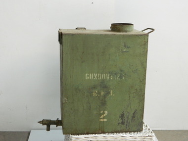 Kiewa Valley Historical Society
Water tank - Gundowring, 1923
... Water tank - Gundowring...gundowring fire brigade. cfa. drinking water. water... be turned to allow the water in the tank to come out.. At the top... Gundowring Fire Brigade tanks may have been used for drinking water ...The two Gundowring Fire Brigade tanks may have been used for drinking water for the fire fighters. Their curved side and handles indicate that they were attached (strapped) to horses or a round tank and transported to the fire.This tank was used for drinking water for the fire fighters of Gundowring during the 1923 fire. Some of their equipment was hand made. The Gundowring Fire Brigade was a rural fire brigade operating in 1923.Green rusty metal rectangular tank with an opening at the top but no lid. At the bottom on one side there is an horizontally extended pipe with a flat knob at its end that can be turned to allow the water in the tank to come out.. At the top of the tank is a rectangular hollow metal handle. There is also a handle on the top of the opposite side. There are 2 smaller triangular hollow metal 'handles' at the top of the straight side (for strapping). There is one square hollow metal handle in the middle of the bottom of the same side which is also the curved side. This side is curved vertically. The side opposite the curved side has a white inscription.Side: Gundowring R.F.B. (Rural Fire Brigade)gundowring fire brigade. cfa. drinking water. water container. horses. tank. bushfire. -
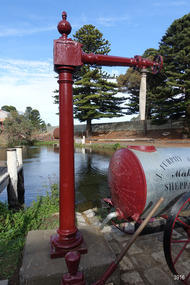 Flagstaff Hill Maritime Museum and Village
Functional object - Water standpipe, Langlands Bros. & Co, 1880-1893
... . They relied on rain water tanks, domestic wells and springs. The town... on rain water tanks, domestic wells and springs. The town ...This water standpipe is believed to be the only one of its kind in working order. It was originally located in Warrnambool, on the hillside at the corner of Mickle Crescent and Banyan Street, providing water for the Chinese Market Gardens below, on the flats. It was removed from this location on May 2nd, 1979, with the intention to relocate it at the new Flagstaff Hill Maritime Museum & Village. The standpipe lay in storage for years until the Warrnambool Company, Chemblast, offered to restore it for use as a working display. The display was officially opened on March 31, 2014. The water from the adjacent lake is drawn out with a hand operated water pump, and goes up into the standpipe, where flows through the canvas hose and into the top of the Furphy Farm Water Cart. The display is a visual acknowledgement of the years served by Flagstaff Hill volunteer and Friends of Flagstaff Hill Chairperson, Bob Crossman. Warrnambool’s early settlers had no water supply prior to the mid-1850s. They relied on rain water tanks, domestic wells and springs. The town experienced a huge, destructive fire in William Bateman Jnr. & Co.’s large produce store in November 1856, which highlighted the need for both a fire brigade and a good supply of water. In 1863 a volunteer fire brigade was established. In August 1880 the town celebrated the installation of its first water standpipe on the corner of Liebig and Timor streets. The water was pumped from springs at Cannon Hill through the connected pipeline to the standpipe, then distributed to households via horse and cart. Each of the licenced cart drivers were compelled by Council regulations to keep their carts full from sunset to sunrise, ready to cart water to outbreaks of fire. They received a fee for this service. In 1893 the town installed a water supply, sourced from the Merri River, stored in a reservoir basin and tower in north Liebig Street, and distributed throughout the town in a system of pipes. By late 1939 a reticulated supply was installed, with the water piped in under the Otway Scheme. Standpipes are still used in modern times in rural and remote areas for homes, farms, stock, agriculture and firefighting. Many commercial or government owned standpipes are metered, charging a fee for the quantities of water supplied. This water standpipe was made by Langlands Foundry Co. Limited, Melbourne, which was establish in 1842. It was Melbourne’s first foundry and iron shipbuilder, and one of the largest employers in Victoria at the time. Langlands was known for its high quality workmanship and wide range of goods for mining, engineering, marine, railway and other industrial uses. The company made the first cast bell, the first lamp posts in the colony, and the boiler for the first Australian train. In the 1860s it produced cast iron pipes for the Board of Works, which laid the pipes for Melbourne’s first reticulated water supply. The firm was bought by Austral Otis Co. in 1897.This water standpipe is significant historically as it is believed to be the only one of its type in working condition. The standpipe is significant for being manufactured by early colonial firm Langlands Foundry of Melbourne, which was known for high quality, cast iron products. The firm made the boiler for the first Australian train, assembled the first Australian paddle steamer and made the first Australian cast bell and lamp posts. Langlands was one of the largest employers in Victoria at the time. The standpipe is significant historically as it represents the evolution of water supply services in Australia. Standpipe; vertical cast iron water pipe, painted crimson, fixed in position, tapering inward from the round base to the rectangular joint near the finial on top. A hexagonal pipe extends at right angles from the joint, with an outlet fitting and flow-controlling wheel on the end. A length of canvas hose hangs from the outlet fitting. Inscriptions are on one face of the joint. The standpipe was made by Langlands Foundry Company of Melbourne. Embossed “LANGLANDS FOUNDRY CO. / LIMITED / ENGINEERS / MELBOURNE”warrnambool, flagstaff hill maritime museum, maritime museum, shipwreck coast, flagstaff hill maritime village, great ocean road, flagstaff hill, standpipe, stand-pipe, water standpipe, fire standpipe, firefighting equipment, water supply equipment, chinese market gardens, banyan street, liebig street, water tower, bateman’s fire, working display, water supply, town water, rural water, reticulated water, cannon hill spring, merri river, otway water, water carters, horse and cart water supply, volunteer fire brigade, langlands foundry, early melbourne, iron works, bob crossman, late 19th century water supply