Showing 4636 items
matching avenue
-
 Canterbury History Group
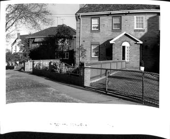
Photograph - Canterbury Road, Canterbury, Jan Pigot, c 1990s
Black and white photograph of Canterbury Road Canterbury from opposite Willandra Avenue looking to the westcanterbury, canterbury road, canterbury mansions, railway bridges, power and telegraph lines, telegraph and light poles, canterbury post office -
 Chelsea & District Historical Society Inc
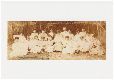
Photograph - Bella Bull and Musical Group Bull and Bush, c 1907
Sepia photo of a group of 7 men and 11 women on beach at Carrum near Mascot Avenue"Down at the Old Bull and Bush" Carrumchelsea, beach, fashion, entertainment -
 Kew Historical Society Inc
Plan - Subdivision Plan, J R Mathers & McMillan, Myrtle Hill Estate, East Kew, circa 1949, c.1949
The Kew Historical Society's map collection includes a substantial number of real estate subdivision plans, mainly of Kew but also of surrounding suburbs in Melbourne. Most of the subdivision plans date from the 1920s and 1930s when the districts old homes and local farmland were being split up to accommodate residential growth in the postwar period. These early plans were assembled by a local firm, Jas R Mather & McMillan, which had an office in Cotham Road. Many of the plans, and sometimes photos, were annotated by the agents.Subdivision plans are historically important documents used as evidence for the growth of suburbs in Australia. They frequently provide information about when the land was sold as well as evidence relating to surveyors and real estate and financial agents. The numerous subdivision plans in the Kew Historical Society's collection represent working documents, ranging from the initial sketches made in planning a subdivision to printed plans on which auctioneers or agents listed the prices for which individual lots were sold. In a number of cases, the reverse of a subdivision plan in the collection includes a photograph of a house that was also for sale by the agent. These photographs provide significant heritage information relating house design and decoration, fencing and household gardens.The photograph may also be aesthetically significant depending on the importance of the photographic atelier.Myrtle Hill, at 14 Vista Avenue, Kew, is of local historical and architectural significance as a good example of a large and imposing single-storey Italianate house of the early 1870s surviving in Kew. Originally sited on a large allotment overlooking Normanby Road, the setting of the house has been dramatically altered through extensive subdivision and development. The subdivision plan of the ‘Myrtle Hill Estate’ indicates that in one such subdivision, 11 allotments were created fronting Bowyer Avenue, Myrtle Avenue, and Normanby Road. The outline and building profile of Myrtle Hill is shown on the west side of Bowyer Avenue.The full (typed) title of this subdivision plan is :"Plan of SUBDIVISION of part of CROWN PORTION 83. / at KEW / PARISH OF BOROONDARA. / COUNTY OF BOURKE". / "MYRTLE HILL ESTATE / EAST KEW" In addition to the Title and subtitle, the plan also lists the advantages of the subdivision. -
 Ringwood and District Historical Society
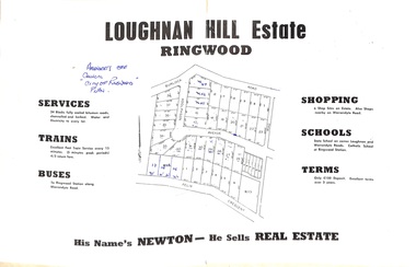
Document - Folder, Subdivision Map - Loughnan Hill Estate, Ringwood, Victoria - circa 1960
Open centre page of land sale brochure glued to manilla folder. Map of residential and shop sites in Burlock Road (later Burlock Avenue), Adolphson Avenue and Felix Crescent, Ringwood, with summary of estate facilities and local services. Agent - T.G. Newton.(Page glued to manilla folder prevents access to front page for further sale information) -
 City of Ballarat
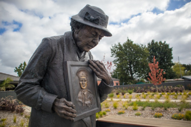
Artwork, other - Public Artwork, Peter Corlett, The Grieving Mother by Peter Corlett, 2017
The Garden of the Grieving Mother is an acknowledgement of the trauma, grief and anxiety felt by the families of Australian servicemen and women. Of the 3,801 WWI service men and women commemorated in the Ballarat Avenue of Honour, 1 in 5 made the ultimate sacrifice, giving their lives. At the centre of the memorial space is a bronze sculpture of a mother clutching a photograph of her son by sculptor Peter Corlett who has created many war memorial public artworks. The memorial was unveiled on 15 February 2017 by Governor General Sir Peter Cosgrove and Mrs Kaye Baird, mother of posthumous Victoria Cross recipient, Corporal Cameron Baird.Bronze sculpture installed in landscaped garden on lit plintha mother grieving the loss of her child at war -
 Greensborough Historical Society
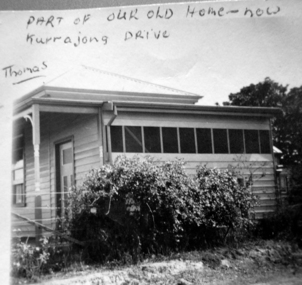
Photograph - Digital image, Mavis Solum's old home, 1950s
Photograph of the home of the Thomas family. Mavis Solum (nee Thomas) provided the photograph to accompany an oral history, published in "As I Recall".Digital copy of black and white photograph.Written on photograph: "Part of our old home now Kurrajong Avenue - Thomas"mavis solum, solum family -
 Ringwood and District Historical Society
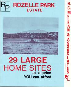
Flyer, Subdivisional Land Sale Brochure, Rozelle Park Estate, Ringwood East, Vic. - circa 1968
Folded land subdivision sale advertisement for 29 home sites, with location map and summary of local facilities and services. Separate price list leaflet enclosed with terms of sale.Subdivision includes Wingate Avenue and Rozelle Avenue, Ringwood East. Agent - H.G. McLean & Associates Pty. Ltd., 166 Canterbury Road, Heathmont. Phone 870 3422 A/H 870 5879. -
 Ringwood and District Historical Society
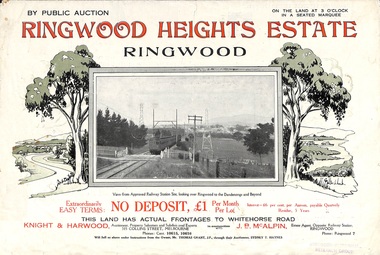
Flyer, Subdivision Advertisement - Ringwood Heights Estate Public Auction - March, 1924
Refer also to Reg. No. 5185 for Ringwood Heights Estate final section release (August 1924)Folded double-sided brochure advertising Ringwood Heights Estate Public Auction on Saturday March 1, 1924, with town photographs, location map, terms of sale, and summary of local features and services.Subdivision includes Whitehorse Road, Bon View Avenue, Grant Crescent, Hillcrest Avenue, Heatherbrae Avenue, Margaret Street, and Mary Street. (Agents) Knight & Harwood, 315 Collins Street, Melbourne, Phones Central 10615, 10616, in conjunction with J.B. McAlpin, Opposite Railway Station, Ringwood, Phone Ringwood 7. -
 Phillip Island and District Historical Society Inc.
Photograph
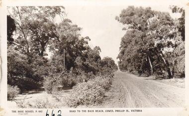
Part of collection donated to the Museum by Mr. Bernard Grayden. 1975Postcard showing unmade road through trees leading to Back Beach, Phillip Island. (Thompson Avenue)Road to the Back Beach, Cowes, Phillip Island, Victoria. The Rose Series P662local history, documents, postcards, phillip island, black & white postcard, back beach road phillip island, bernard grayden -
 Phillip Island and District Historical Society Inc.
Photograph, 1900
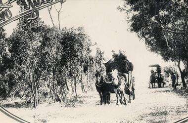
One of a collection of over 400 photographs in an album commenced in 1960 and presented to the Phillip Island & Westernport Historical Society by the Shire of Phillip IslandCopy of a Postcard of Horse Drawn Lorries carting wool along Thompson Avenue in the early 1900'slocal history, photography, wool carting, black & white photograph, horse transport, wool industry, thompson avenue cowes, john jenner, bryant west -
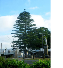 Mortlake and District Historical Society
The Peace Tree
This Norfolk Island pine tree was planted in 1919 as 'The Peace Tree'. A community gesture signifying the embrace of 'peace' as a valuable concept symbolised by the planting of a tree. [from Mortlake Dispatch] PEACE DAY 1919. Throughout the Empire three days were marked as Public Holidays including Peace Day in July 1919. Mortlake observed Peace Day by Peace Medals being distributed at the State School, Union Jacks being flown from many buildings and houses and the Peace Tree being planted at the intersection of Officer Street, Jamieson Avenue and Shaw Street. Then followed a procession [of local people]. It is assumed the Progress Association, which undertook the Avenue of Honour, also was responsible for planting the Peace Tree. Norfolk Pine tree located on eastern corner of Officer Street, Shaw Street and Jamieson Avenue intersection.1919, peace, norfolk island pine -
Glenelg Shire Council Cultural Collection
Slide - Slide - Glass Plate Negative Queens Avenue Portland, 1890-1910
Glass plate negative. 'Queens Avenue' - Percy Street looking north from the Julia Street corner. -
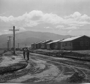 Kiewa Valley Historical Society
Photo: Beauty Ave., Mt Beauty
Mt Beauty was built as a construction town by the S.E.C.V. for workers on the K.H.E.S.. Thee 5 houses in Beauty Ave were the first to be built.The power lines were already erected.Photo: Sepia photo of 5 new houses built at Mt Beauty on the higher side of Beauty Avenue.mt beauty township, beauty avenue -
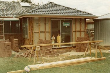 Ringwood and District Historical Society
Photograph, Adding a room onto the Mitchell house at 168 Oban Road, North Ringwood in February 1979
Near the corner of Cormistom Road and Florence Avenue onto Oban Road. The house is still there today (2024).Taken by Roy J Mitchell -
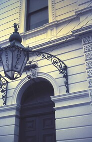 Bendigo Historical Society Inc.
Slide - BENDIGO & EASTER FAIR, 1968
Lamp at Sandhurst Hotel. Corner of Lyttleton Terrace and St Andrews Avenue, Bendigo. (114 years old)slide, bendigo, sandhurst hotel, sandhurst hotel lamp -
 Port Melbourne Historical & Preservation Society
Photograph - Houses in Southward Avenue, Andrew U'REN, C. 1970s - 1980s
From a box of photographs in Nancy U'REN's papers used during research for her thesis, The Early Growth and Development of Sandridge (1976) and/or her book with Noel TURNBULL, A History of Port Melbourne (1983). The print was probably made by her son, Andrew U'REN, and he may have also taken the photograph.Black and white photograph of No 13 and No 11 Southward Avenue with other houses in the street also visible in the photograph.built environment - domestic, dunstan estate, southward avenue, nancy u'ren nee morris -
Whitehorse Historical Society Inc.
Document, McCracken Street, Blackburn South, 1995
History of McCracken Street, Blackburn South by Beryl Gray, Nunawading Historical Society [actually McCracken Avenue]History of McCracken Street, Blackburn South by Beryl Gray, Nunawading Historical Society [actually McCracken Avenue]History of McCracken Street, Blackburn South by Beryl Gray, Nunawading Historical Society [actually McCracken Avenue]street names, mccracken avenue, blackburn south, orchard grove, blackburn south, lawrence street, blackburn south, gray, beryl -
Whitehorse Historical Society Inc.
Document, Advance Blackburn!, c. 1900
Circular letter and street plan regarding donations sought to fund a proposed extension of The Avenue to Blackburn Road.Circular letter and street plan regarding donations sought to fund a proposed extension of The Avenue to Blackburn Road.Circular letter and street plan regarding donations sought to fund a proposed extension of The Avenue to Blackburn Road.blackburn road blackburn, elmore, algernon john, williams, e. g., page, chas. d, the avenue, blackburn -
 Whitehorse Historical Society Inc.
Photograph, Sub-division of the former Mitcham Technical School, 01/01/1998
Sub-division of the former Mitcham Technical School C.1996. Looking towards Carter Avenue, Nunawading.mitcham technical school, knightsbridge subdivision, nunawading, cherrybrook close, carter avenue -
 Whitehorse Historical Society Inc.
Photograph, Auction Plan of Eastdawn Estate, Mitcham, 1915
Black and white strip photo of Auction Plan of Eastdawn Estate, Mitcham Road and Orient Avenue, Mitcham.auctions, plans, eastdawn estate -
 Robin Boyd Foundation
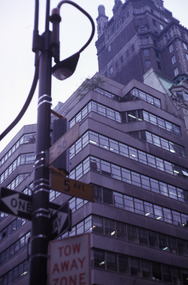
Slide, Robin Boyd, 1969
Robin Boyd travelled to the USA and Britain for several weeks. He attended the opening of the new Australian Chancery in Washington DC, where he had designed an innovative exhibition with cylindrical display cases and sound recordings.Colour slide in a mount. Corner 5th Avenue and 56th St, New York, New York, USAMade in Australia / 25 / JUL 69M2slide, robin boyd -
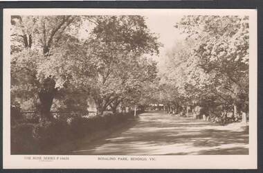 Bendigo Historical Society Inc.
Photograph - ROSALIND PARK: BENDIGO
Black and white postcard: , Rosalind park, Bendigo. Image shows avenue of trees in Rosalind Park, Bendigo.bendigo, parks and gardens, bendigo, rosalind park -
Canterbury History Group
Document - Occupants list of west and eastern sides of Wentworth Avenue 1926-1927
Typed list of inhabitants of Wentworth Avenue 1926-1927 with notes compiled by Gladys Sayers nee Mateercanterbury, grocers, wentworth avenue, houses, love wisdom power -
Canterbury History Group
Photograph - 4 Victoria Avenue Canterbury, c1912
View of 4 Victoria Avenue Canterbury looking north from Canterbury Road.[1912} sepia photographcanterbury, victoria avenue, roads and streets, street trees -
Canterbury History Group
Photograph - Beryl, Eleanor and Rosemary Golding, [1930s]
Beryl, Eleanor and Rosemary Golding in the front garden of 12 Hopetoun Avenue Canterbury black and white photographcanterbury, hopetoun avenue, golding family, clothing and dress -
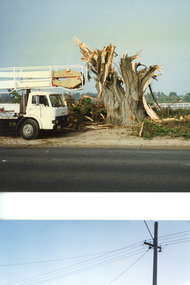 Lakes Entrance Historical Society
Photograph - Memorial Cypress trees, 1999
Carved by chainsaw artist John Brady.Colour photograph of cypress tree being cut down on WW1 Memorial Avenue Lakes Entrance Victoriaworld war 1914-1918, memorials -
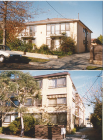 Melbourne Legacy
Photograph, Widows' Flats, c.1989
A photo of a block of flats in Sellwood St Hawthorn (top photo) and a block at 9 The Avenue, Windsor (bottom photo) that Legacy owned and leased at reasonable rates to widows in their care. It was with a group of photos from 1988 to 1990 in a folio with paper labels (see items 01042 to 01053). The September 1975 edition the widows newsletter mentions the 20 flats purchased by Legacy at 9 The Avenue and they are being renovated for widows to live in. Two options were presented, an 'ingoing' amount of $5,000 then a week maintenance charge of $7 a week; or on a rental basis of approximately $20 a week. A photo of the Windsor units in 1976 is at 01412. This photo of the Windsor flats was taken after 1981 when sun blinds were added to the building (from a Highlights of President report in 1981). The group of flats was known as 'Windsor Lodge' until 1987 when it was renamed 'The Miriam and Frederick James Ramsay Lodge'. From copies of the Title Deeds; 9 The Avenue Windsor was purchased on 7 February 1975, and 22 Selwood St Hawthorn was purchased on 28 June 1974. It was decided the Windsor units, and the ones in Hawthorn, would be sold in 2003 and announced by President Tony Parkes. The decision was published in Leader newspapers and Jellis Craig approached Legacy about the sale, see items at 01089.A record of Legacy supporting widows throughout their lives.Colour photo x 2 of widows' flats in Hawthorn and Windsor.Handwritten on back "Hawthorn Court / 22 Selwood St / Hawthorn East 3123". The other has 'Pic 4 / Miriam and Frederick Ramsey Lodge / 9 The Avenue Windsor 3181' in black pen. Yellow paper label was a note from Terry to Susie listing photos of widows flats in Hawthorn, Windsor and Clubrooms but only the Hawthorn and Windsor flat photos are attached.widows, properties -
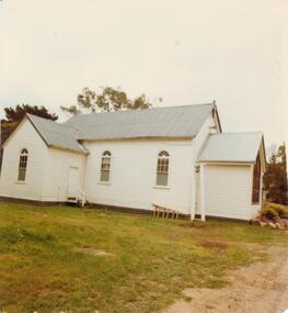 Phillip Island and District Historical Society Inc.
Photograph, 1978/79
The site on the corner of Thompson Avenue and Church Street, Cowes was reserved on the 12th April 1869 and the church was erected by the end of the year. Financed by the Island Church of England people. Dean McCartney preached the first sermon and performed the dedication service on 30th January 1870. Prior to this time services were held at the McHaffie homestead, Ventnor. Mrs S D (Georgianna) McHaffie, wife of the first European settlers, wrote in her diary "30th January 1870. Drove to Cowes, opened the Church, fine day". the large Bible presented by her is on loan and displayed in the Museum of the Phillip Island & District Historical Society.The timber Anglican Church of St Philips was built by Alex McLardy Sen. in 1869. It is still situated in Thompson Avenue on the corner of Church Street. The Vestry was added by Mr Alex McLardy in 1903 at the cost of 21 pounds. In 1912 a Sanctuary was added to the church and a Memorial Stained Glass Window donated by Miss Rose in memory of her father and two brothers was installed.local history, photographs, buildings, historic, buildings - historical, coloured photograph, john cook, phillip island, anglican church -
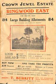 Ringwood and District Historical Society
Flyer, Subdivisional Land Sale Brochure, Crown Jewel Estate, Ringwood East, Vic. - c.1925
In May 1884, George Smart of Bulleen Road Kew, brickmaker, bought the 23 acres one rood and twenty nine and three tenths perches, or 9.4834 hctares from Arthur Bailey Clements of Ringwood for the sum of 600 pound sterling. (Extract from The Story of the Crown Jewel Estate in Ringwood East pdf)Double sided folded page with black and red print on both sides advertising auction sale of residential and business sites and highlighting local facilities, services and layout of the estate.Subdivision includes Mount Dandenong Road, Valda Avenue, Evon Avenue, Mirabel Avenue, and Velma Grove. (Agent) T. Burkitt, Box 12 Ringwood, Phone Ringwood 157. Vendor: A. Marshall Miller, McDonald Street, Mordialloc. Solicitors: Russell, Bona and Russell, 19 Queen Street Melbourne, and Ringwood - Phone Cent. 4308. -
Ringwood and District Historical Society
Booklets, Jack Lundy, 28 booklets containing verses and stories by Jack Lundy of Ringwood. 1977-1983, 1977-1983
28 booklets containing verses and stories by Jack Lundy, Burlock Avenue, Ringwood. +Additional Keywords: Lundy, JackCatalogue of the writings of Jack Lundy (2 copies); Ringwood Memories. No.1 Loughnans Lake (1978); Ballads From The Dandenongs No.1 (1977) (2 copies); Ballads From The Dandenongs No.2 (1977); Ballads From The Dandenongs No.4; Ballads From The Dandenongs No.5; Ballads From The Dandenongs No.6 (1977) (2 copies); Ballads From The Dandenongs No.9 (1978); Ballads From The Dandenongs No.10 (1977) (3 copies); Ballads From The Dandenongs No.11; Ballads From The Dandenongs No.12 (1979) (2 copies); Ride Billy Ride - Jack Lundy (2nd edition May 1983); More Ballads From The Dandenongs (1980) (2 copies); Tales From The Dandenongs No.1; Tales From The Dandenongs No.2 (1978) (2 copies); Tales From The Dandenongs No.5 (1978); Tales From The Dandenongs No.7 (1982); Tales From The Dandenongs No.8 (1983) (2 copies); More Tales From The Dandenongs (2 copies)