Showing 11164 items matching "planning "
-
 Whitehorse Historical Society Inc.
Document, Parish of Nunawading
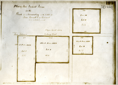
Plan of four farms in the estate of John BarrattPlan of four farms in the estate of John Barratt on Delaneys RoadPlan of four farms in the estate of John Barratt parish of nunawading, barratt, john, delaney's road, ringwood north, elgars special survey, land subdivision -
 Whitehorse Historical Society Inc.
Pamphlet, Springvale Road Rail Separation project, 2009
Overview and concept plans for the rail separation and Nunawading railway station.Overview and concept plans for the rail separation and Nunawading railway station.Overview and concept plans for the rail separation and Nunawading railway station.springvale road nunawading, springvale road rail separation project, nunawading railway station, springvale road rail alliance -
Whitehorse Historical Society Inc.
Document, Box Hill Gardens Master Plan, 2011
City of Whitehorse plans for Box Hill Gardens, Feb 2011.City of Whitehorse plans for Box Hill Gardens, Feb 2011.City of Whitehorse plans for Box Hill Gardens, Feb 2011.box hill gardens, plans -
 Whitehorse Historical Society Inc.
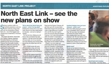
Article, North East Link Plan, 2018
Plans for the North East Link project can be viewed at northeastlink.vic.gov.auPlans for the North East Link project can be viewed at northeastlink.vic.gov.auPlans for the North East Link project can be viewed at northeastlink.vic.gov.aunorth east link, eastern freeway, bicycle paths -
 Ballarat Heritage Services
Plan, Lanercost Priory, Digital copy made 2016
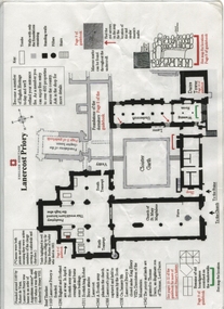
Lanercost Priory was founded around 1169 by Robert de Vaux, and was home to an order of Augustinian canons until 1538 when is was dissolved by Henry VIII. In 1542 the priory and lands were granted to Thomas Dacre, an illegitimate son of Thomas, Lord Dacre. Mason's marks can be found throughout the undercroft. Plan on white paper with black and red ink printing and a drawingEnglish Heritage Lanercost Priorymason's marks, marks, stone marks, stonemasons, lanercost, priory, plan, 1169 -
 Ballarat Heritage Services
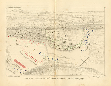
Plan, Eureka Stockade Attack Plan, 1854
Plan of the Eureka Stockade attack by the military on 03 December 1854.eureka stockade, attack, battle, samuel huyghue, warrenheip, plan -
 Numurkah & District Historical Society
Plan - Plan of Numurkah Railway Station Fire Fighting Equipment
Part of railway collection from closed Numurkah Railway StationWooden Framed Blueprint Plan pasted onto a Masonite backing.VR Numurkah WS and Fire Fighting Equipment -
Robin Boyd Foundation
Document, McCay & Thwaites (Barristers & Solicitors), 1957
Letters to Robin Boyd (14th and 26th August, 1957) regarding acquisition and contract for purchase of land at 290 Walsh St, South Yarra.Five pages, including two letters, plans and rough calculation. -
 Old Colonists' Association of Ballarat Inc.
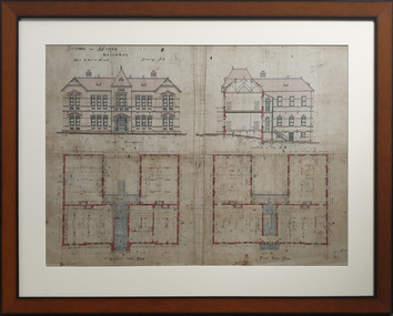
Print, Ballarat School of Mines Administration Building
Framed copy of a plan of the Ballarat School of Mines Administration Building.ballarat school of mines, administration building, a building, architecural plan -
 Queenscliffe Maritime Museum
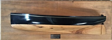
Leisure object - Half model 1890 couta boat
Half model of an 1890 couta boat made to plans of 'Ariel'1890's Couta Boat Victoria Aust.couta boat, 'ariel', half model -
 Queenscliffe Maritime Museum
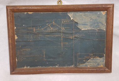
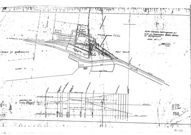
Plan - Proposed buoy depot at Queenscliffe 14/9/1926, Government Works plan of buoy depot proposal, 1926
Queenscliffe buoy depot locationHistorical details of proposed buoy depotphotocopy of a plan showing proposed buoy depot location 1926Reverse " NIL ".historical references -
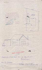 Bendigo Historical Society Inc.
Document - DOCUMENT. PROPOSED CAR PORT, 1974
Document. Plans for Proposed Car Port. 12 Bolt Street. -
Stawell Historical Society Inc
Map, Plan Shewing Auriferous Deposits and Reefs (Map of Water Races), c1878
Plan Shewing Auriferous Deposits and Reefs (Map of Water Races)stawell, water -
Stawell Historical Society Inc
Map, Plan of Apsley Co. Prospectus Apsley Gold Mining Company, 1895
Plan of Apsley Co. Prospectus Apsley Gold Mining Companystawell -
University of Melbourne, Burnley Campus Archives
Plan, Department of Public Works, Layout of UG and OM Cables sub-station area - Burnley Gardens, c. 1960
Copy of State of Victoria, Department of Public Works plan of cabling.cabling, department of public works, burnley gardens -
University of Melbourne, Burnley Campus Archives
Plan, Arrangement of Soil Sterilizing Room for New Plant Science Laboratory at Burnley College of Horticulture, c. 1960
Plan by State of Victoria, Dept of Public Works. Drawn by R.M.department of public works -
University of Melbourne, Burnley Campus Archives
Plan, Detail of Sterilizing Trolley for New Plant Science Laboratory at Burnley Horticulture College, c. 1960
Plan by State of Victoria, Dept of Public Works. Drawn by R.M.department of public works -
University of Melbourne, Burnley Campus Archives
Plan (Item), Vireya Rhododendrons
vireya rhododendron, burnley gardens -
University of Melbourne, Burnley Campus Archives
Plan, Sue Parker, Planting Plan Contemporary Garden, 1989
Coloured plan by Sue Parker Sheet No 5 dated 23.05.1989.sue parker, gardens -
University of Melbourne, Burnley Campus Archives
Plan, Landscape Construction I Paving on Mortar, 1990-2000
Plan of paving construction. Fall to Grade. Scale 1:20.landscape construction, paving -
 Public Record Office Victoria
Report, 27 October 1854
VA 856 Colonial Secretary's OfficeEureka Stockade:Captain MacMahon reports on plans for the defence of the Government Camptrial, licencing, eureka, diggers -
University of Melbourne, Burnley Campus Archives
Plan - Planting Design, Gibson North Island Bed
emily gibson, plant list, garden plan -
University of Melbourne, Burnley Campus Archives
Plan, Business Services, Burnley Campus, 27.11.2020
plan of burnley campus, university of melbourne -
Canterbury History Group
Document - Plans of the proposed toilets at Canterbury Bowling Club, 1964
Plans of the proposed additional toilets at Canterbury Bowling Club roomscanterbury, canterbury bowling club, kendall street, plans, toilets, lawn bowls -
 St Patrick's Old Collegians Association (SPOCA)
Photograph - Buildings, SPJC, Rooms, post-1870
-
Port Melbourne Historical & Preservation Society
Plan - Verandah, Shipping Office, Town Pier, Sandridge, 8 Jan 1862
Plan of verandah to shipping office, Town Pier, Sandridge, 1862.Fred. W. Bull (Municipal Surveyor)piers and wharves - town pier, frederick william bull -
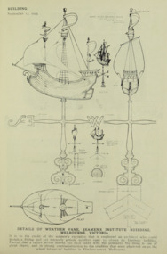 Mission to Seafarers Victoria
Drawing - Digital copy, Building Publishing, Details of weather vane, Seamens' Institute building, Melbourne, Victoria, 12 September 1923
This sketch was published in Building : the magazine for the architect, builder, property owner and merchant, Vol. 33, No. 193 (12 Sept., 1923) but Walter Butler had imagined it in the design for the mission in 1916/17. In the article published in the Herald, Thursday 30 August 1917, page 12, it is mentioned the "the architect has designed a copper ship final for the main gable of the building and it, like the gymnasium, is awaiting the collection of more funds or the generosity of a special donor."The plans confirm that Walter Butler was the designer of the vane that he had already imagined in the early sketch of the Flinders Street building in 1916 and also help us determine when was the vane made.This article was published in 1923 and the first photograph of the weathervane was only published in the 1928 Annual Report. The plans are significant as they could potentially help rebuild the weathervane stole in March 2022. Plans for the weather vane, Seamens' Institute building, Melbourne, Victoriawalter richmond butler (1864–1949), windvane, weathervane, finial, flinders street -
 Bendigo Historical Society Inc.
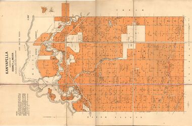
Map - JACK FLYNN COLLECTION: KANYAPELLA, 22/05/1939
Map: Parish of Kanyapella, Counties of Rodney and Moira. Parish plan.By Authority, T. Rider Acting Govt, Printer Melbourne. Drawn and Reproduced at the Dept. of Lands and Survey, Melbourne, Victoria.map, moira, parish plan, kanyapella, counties of rodney and moira -
 Bendigo Historical Society Inc.
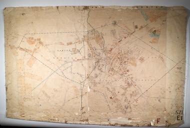
Map - EAGLEHAWK, Circa 1870's
Map: Eaglehawk, Compilation of 2 parish plans covering Eaglehawkmap, bendigo, parish plan, eaglehawk -
 Bendigo Historical Society Inc.
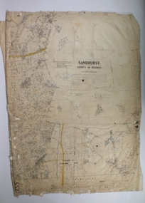
Map - SANDHURST SHEET 1, 27/05/1925
Map: Sandhurst ,County of Bendigo, sheet 1. Parish planmap, bendigo, parish plan, sandhurst