Showing 30432 items
matching hills
-
 Ballarat Heritage Services
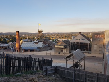
Photographs, PaulMichael Donovan, Ballarat East from Sovereign Hill, 2019, 12/04/2019
Ballarat East from Svereign Hill, including a poppet head.sovereign hill, ballarat east, soho foundry, chimney -
 Ballarat Heritage Services
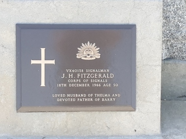
Photograph - Colour, Clare Gervasoni, Headstone of J.H. Fitzgerald in the Tower Hill Cemetery, 2019, 03/01/2019
Colour photograph of the headstone of J.H. Fitzgerald in the Tower Hill Cemetery.VX40138 Signalman J.H. Fitzgerald Corps of Signals 18th December 1966 age 50 Loved husband of Thelma and Devoted father of Barrytower hill cemetery, j.h. fitzgerald, thelma fitzgerald, barry fitzgerald -
 Whitehorse Historical Society Inc.
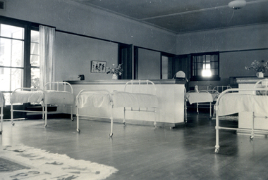
Photograph, Forest Hill Residential Kindergarten - Nursery, c1938
See ND2991 for history of kindergarten.Black & white photograph of the nursery at Forest Hill residential Kindergarten.forest hill residential kindergarten, kindergarten -
 Ballarat Heritage Services
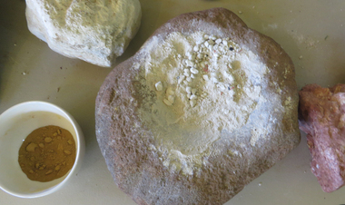
Photograph - Colour, Clare Gervasoni, Grindstone and Ochre, 25/12/2015
Photograph of a Grindstone and Ochre on display at the Tower Hill Interpretation Centre.tower hill, grindstone, ochre, aboriginal, aborigines -
 Ballarat Heritage Services
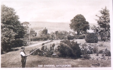
Postcard, Wombat Hill Gardens, Daylesford
Black and white postcard of LWombat Hill Botanical Gardens, Daylesford.wombat hill botanical gardens -
 Bendigo Historical Society Inc.
Plan - MARKS COLLECTION: COPY OF UNDERGROUND & SURFACE WORKINGS VICTORIA HILL BALLERSTEDT CLAIM
Copy of the underground and surface workings at Victoria Hill, Ballerstedt Claim.bendigo, mining, ballerstedt victoria hill -
Stawell Historical Society Inc
Archive - CD/DVD, CD containing files from creation of 1866 Panorama of Stawell from Big Hill 1866, 2008
Scans made at photographer in Main Street and Digitally Combined. Gold CD with writing Stawell from Big Hill 1866stawell, gold mining -
 National Wool Museum
Photograph - Havilah Station, Mudgee, New South Wales, J W Allen, 1928-1929
This photograph was found loose in the first of three albums compiled and owned by J W Allen, Secretary of New South Wales Grazier's, and is associated with the New South Wales Graziers Association world tour of sheep 1928-1929. The album contains photographs of travel, sheep, farms, stations, people and landscapes from around the world. Locations include Naples, Port Said, Suez, Birregurra (Vic), Alexandra (Vic), Ballangeich (Vic), Keith (SA), Mt Gambier (SA), Buckland Park (SA), Tasmania, Winton (QLD), Sydney Harbour, Canberra (ACT), Toowoomba (QLD), Rockhampton (QLD), Tocal (NSW), Deepwater (NSW), Glen Innes (NSW), Longreach (QLD), Moree (NSW), Barraba (NSW) and Mudgee (NSW). Properties depicted include Mooleric, Turkeith, Woolongoon, Minadale, Crower Station, Merrindie, Koomooloo Station, Cappeedee, Koonoona, Rathmore, Ellenthorpe, Camden Park Station, Glenlegh, Strathmore Station, Ilparran Station, Binneguy, Midkin, Terlings, Ashley, Bereen, Plumthorpe, Mayvale and Havilah. The album was found in a clean out at the Great Southern Agricultural Research Institute and donated to the National Wool Museum, along with other related material such as photographs, glass lantern slides and ephemera.Black and white photograph showing a landscape with sheep and hills in the background. back: [handwritten] Havilah(?)[?] (Erambie) / [printed] KODAK PRINT / B 057 / VELOXagriculture, sheep, farming, stations, research, breeding, photography, travel -
 Port Fairy Historical Society Museum and Archives
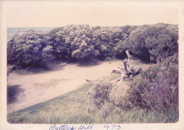
Photograph, Battery Hill 1973
East Beach car park in the 1970’s Coloured photograph of Battery Hill car park surrounded by treesbattery hill, car park, east beach, tea tree -
 Port Fairy Historical Society Museum and Archives
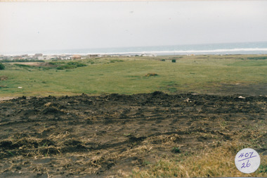
Photograph
South Beach Development Coloured photograph of Earthworks on hill with south beach estate in distance407/26 (since removed 2021)south beach, development -
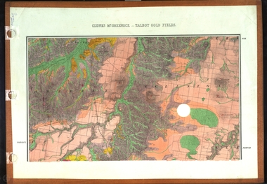 Federation University Historical Collection
Map, Clunes, Mt Greenock, and Talbot Gold Fields, 1883, 1883
A geological plan of the Clunes, Mt Greenock, and Talbot Gold Fields in two parts. .1) This section of the map includes Talbot, Talbot water supply race, Mt Glasgow, Little Green Hill, Middle Hill, Mt Cameron, Ballarat Hill, Bakery Hill, Goodwoman Hill, Scandanavian Lead, Eglinton Swamp, McCallum's Creek, Tullaroop Creek, Dunach, Maryborough Railway, Middle Creek and includes many mines such as Rip Van Winkel, Union Extended, South Greenock, Nicholl's Freehold. .2) This section of the map includes McCallums, Clunes, Green Hill, Mt Beckworth, Mt Gap, Maryborough Reservoir, and includes mines such as Lothair, Bute, Clyde, Clunes Consols, London and Australian, Oriental,clunes, talbot, water supply, railway, geology -
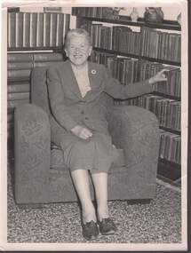 Bendigo Historical Society Inc.
Photograph - LUCY HILL
Lucy Hill (nee Bobotham) Photograph. This photo of a smiling suited lady sitting in armchair in a library is Lucy Hill journalist for the Advertiser. (photo is in this collection). Lucy Hill published childrens stories and poems under the pen-name of Aunt Evelyn. She won the competition for writing the words for The Centenary Song. As Lucy Bobotham she was presented the First Prize for the Gravel Hill State School Choir competition. Mr & Mrs Hill also published in the Advertiser under "In the Spot Light". Lucy Hill has written extensively for many metropolitan papers and magazines, short Stories, verse, series (An Unexpected Achievement), song lyrics (The Centenary Song) and children's pages. She was also noted as a Bendigo historian.person, individual, lucy hill, journalist, advertiser, aunt evelyn, the centenary song, gravel hill state school, in the spot light, an unexpected achievement, bendigo. -
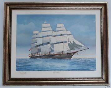 Flagstaff Hill Maritime Museum and Village
Print - Maritme, Colonial Clipper Schomberg, 1992
This framed print of the famous clipper ship “Schomberg” is associated with Flagstaff Hill’s collection of artefacts from the wreck of the “Schomberg”. The original was painted in 1992 by maritime artist Philip J. Gray. This limited edition print is number 9/1000. ABOUTH THE SUBJECT – “Schomberg” The Schomberg was a luxury ship built in 1855 to bring immigrants from the UK to Australia in superior comfort. The voyage could take three months or longer but Captain ‘Bully’ Forbes thought that he could sail the Schomberg from Liverpool to Melbourne in a record time of 60 days. On October 6th 1855 the Schomberg left Liverpool on its maiden voyage. She carried 430 passengers plus 3000 tons cargo including rail lines for Geelong and iron for a bridge in Melbourne. After 78 days at sea, on December 27th, Schomberg ran aground near Peterborough, Victoria. All on board were rescued the next day by the passing steamer SS Queen. Gray is well known for his depiction of maritime history. His meticulous attention to detail shows the enormity of the immigrant clipper with its huge billowing sails compared to the tiny figures at work on the deck. The busy crew can be seen attending to the rigging, as can a group of sailors working on the bow under supervision. He identifies the company logo of the Black Ball Ship Line by the flapping white flag with its black circle. Divers from Flagstaff Hill including Peter Ronald (former director) salvaged artefacts and personal effects from the wreck, to be preserved and displayed. Amongst these is the famous Schomberg Diamond ring. ABOUT THE ARTIST – Philip James Gray “Philip is one of Australia’s leading maritime artists and his meticulous research and social commentary paintings of ships, such as, the Loch Ard and Schomberg form an important part of Warrnambool’s Flagstaff Hill Maritime Museum.” [ref. Dr Marion Manifold, Artist and Art Historian, 2014] Philip James Gray was born in London but has lived most of his life in Australia. He graduated from a London school of art as an illustrator, specialising in technical and scientific illustration as well as other commercial and applied art. He was also a student for a time of Fyffe Christie - British figurative artist, mural painter and humanitarian – who had a great influence on his career. Philip has always worked as a professional artist and illustrator. Many publications on maritime history have featured his work. His paintings have been released and sold all over the world as limited edition prints. The State Library of Victoria’s ‘Latrobe Collection’ holds two of his paintings. His street painting of ‘The Ashes Contest’ decorates the brick wall of Old Bakery Laneway in Sunbury and a Sunbury café owner commissioned him to paint the ‘Sunbury Pop Festival’ as a remembrance of local history. [ref. Sunbury Leader, Nov 15 2013] Philip has been an active member of the Sunbury Art Society in Victoria for several years, serving on the committee for some of that time and being involved in exhibitions. He enjoys helping new artists and sharing his skills and experience. The subject of the sailing ship “Schomberg” is significant for is connection with the 1800s vessel “Schomberg” and the historic role the ship, and other similar ships, played to transport migrants and goods into Australia. The print is significant as it is a limited edition of an Australian maritime artist. Print in gilt timber frame. "The Colonial Clipper Schomberg" by Australian maritime artist Philip J Gray, 1992. Signed and numbered, Limited Edition print 9/1000. Depicts clipper ship “Schomberg”, in full sail at sea with land in background. Backing of frame has illegible adhesive label and pencilled text. Stamp In pencil “FLAGSTAFF HILL” and “FLAGSTAFF C”. Illegible text on adhesive label. Signature [Philip J Gray] Stamped as a limited edition of SCHOMBERG Handwritten edition "9/1000"flagstaff hill, warrnambool, shipwrecked coast, flagstaff hill maritime museum, maritime museum, shipwreck coast, flagstaff hill maritime village, great ocean road, sailing ships, schomberg, clipper ship, colonial clipper, limited edition print, 9/1000, philip j gray, marine artist -
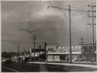
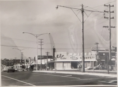 Kew Historical Society Inc
Photograph, Stuart Tompkins Studio, Electricity Supply Poles, Warrigal Road, Ashwood, 1965
Research provided by Stuart Tompkins Studio, Box Hill, into alternatives for median strip street lighting to be used in Burke Road, Kew. The photographers identified variants in different suburbs appropriate to Kew's needs.The series from which the photograph is drawn provides a snapshot by a commercial photographic studio of each named vicinity in 1965 as well as providing examples of public works infrastructure being commissioned by local government in the 1960s. The photos originally formed part of the Engineering Department's files in the City of Kew before being donated to the kew Historical Society.Electricity Supply Poles, Warrigal Road, Ashwood, 1965. Stuart Tompkins Studio provided this photograph for the Kew City Council. The photograph, taken at the intersection of Warrigal Road and High Street South, Ashwood looks north along High Street Road. The intent of the photograph was to provide the Council with models of electricity supply poles. In the photo, wooden and steel poles can be seen in the median strip. The photograph also includes the shops bordering High Street Road during this period. [There are three copies of this photograph in the Collection.]. Typed inscription on reverse: "Electricity Supply Poles. Photographed for Kew City Council 8/2/65. No.4 Warrigal Road - Ashwood. South of High Street Road looking north. Wooden and steel poles with different brackets in median strip." Studio stamp: "Stuart Tompkins Studio. 547 Station Street, Box Hill. WX1439."electric light poles, public works -- 1960s, civic infrastructure -- 1960s -
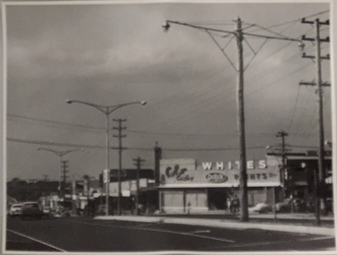
 Kew Historical Society Inc
Photograph, Stuart Tompkins Studio, Electricity Supply Poles, Warrigal Road, Ashwood, 1965
Research provided by Stuart Tompkins Studio, Box Hill, into alternatives for median strip street lighting to be used in Burke Road, Kew. The photographers identified variants in different suburbs appropriate to Kew's needs.The series from which the photograph is drawn provides a snapshot by a commercial photographic studio of each named vicinity in 1965 as well as providing examples of public works infrastructure being commissioned by local government in the 1960s. The photos originally formed part of the Engineering Department's files in the City of Kew before being donated to the kew Historical Society.Electricity Supply Poles, Warrigal Road, Ashwood, 1965. Stuart Tompkins Studio provided this photograph for the Kew City Council. The photograph, taken at the intersection of Warrigal Road and High Street South, Ashwood looks north along High Street Road. The intent of the photograph was to provide the Council with models of electricity supply poles. In the photo, wooden and steel poles can be seen in the median strip. The photograph also includes the shops bordering High Street Road during this period. [There are three copies of this photograph in the Collection.]. Typed inscription on reverse: "Electricity Supply Poles. Photographed for Kew City Council 8/2/65. No.4 Warrigal Road - Ashwood. South of High Street Road looking north. Wooden and steel poles with different brackets in median strip." Studio stamp: "Stuart Tompkins Studio. 547 Station Street, Box Hill. WX1439."electric light poles, civic infrastructure - 1960s, public works -- 1960s -
 Kew Historical Society Inc
Photograph, Stuart Tompkins Studio, Electricity Supply Poles, Warrigal Road, Ashwood, 1965
Research provided by Stuart Tompkins Studio, Box Hill, into alternatives for median strip street lighting to be used in Burke Road, Kew. The photographers identified variants in different suburbs appropriate to Kew's needs.The series from which the photograph is drawn provides a snapshot by a commercial photographic studio of each named vicinity in 1965 as well as providing examples of public works infrastructure being commissioned by local government in the 1960s. The photos originally formed part of the Engineering Department's files in the City of Kew before being donated to the kew Historical Society.Electricity Supply Poles, Warrigal Road, Ashwood, 1965. Stuart Tompkins Studio provided this photograph for the Kew City Council. The photograph, taken at the intersection of Warrigal Road and High Street South, Ashwood looks north along High Street Road. The intent of the photograph was to provide the Council with models of electricity supply poles. In the photo, wooden and steel poles can be seen in the median strip. The photograph also includes the shops bordering High Street Road during this period. [There are three copies of this photograph in the Collection.]. Typed inscription on reverse: "Electricity Supply Poles. Photographed for Kew City Council 8/2/65. No.4 Warrigal Road - Ashwood. South of High Street Road looking north. Wooden and steel poles with different brackets in median strip." Studio stamp: "Stuart Tompkins Studio. 547 Station Street, Box Hill. WX1439."electric light poles, public infrastructure -- 1960s, civic works -- 1960s -
Bendigo Historical Society Inc.
Document - VICTORIA HILL - RECOMMENDATION - MINING PROJECT
Two (a & b) typed copy of a recommendation for mining project, accepted Nov. 1967. Recommendation for Central Nell Gwynne area, now a public purposes reserve for preservation as a permanent reminder of the gold mining era. Victoria Hill Area mentioned for it's geographical and historical significance. The New Chum Hill area rich in historical and mining. Notes on development of the Central Nell Gwynne, Victoria Hill and New or Old Chum Hill areas.mine, gold, victoria hill, victoria hill, recommendation - mining project, central nell gwynne, jack barker, victoria hill area, big 180, victoria quartz, new chum hill (old chum hill), p. m. g. repeater station, mine's department, land's department, lansell, fortuna, a h q survey regiment, lazarus mine, b c v 8 television studio -
 Kiewa Valley Historical Society
Report - Alpine Study Area Volume 2 Maps, Land Conservation Council, 1970s
The Victorian Environmental Assessment Council and the former Environment Conservation Council (ECC) and Land Conservation Council (LCC) have completed 36 land use investigations over more than 35 years, including 27 regional reviews. They provide a framework for use of Public Land in Victoria. The Land Conservation Council was established by the Land Conservation Act 1970.These maps provide an assessment of the Alpine area at the time the maps were created. Some of the topics eg. Rainfall and water resources may change over the years thus providing a comparative analysis. Others may provide information for future development such as mineral exploration, building of a dam / tunnel etc.Blue box shaped folder containing 9 of 10 Maps of the Alpine Study Area produced by the Land Conservation Council. Maps include 1. Public land and descriptive blocks. 2. Physiography. 3. Topography. 4. Geology (missing). 5. Rainfall and water resources. 6. Vegetation 7. Land systems. 8. Recreation. 9. Primary production. 10. Minerals Ex library item. Stamped in red "Discarded From Stock / Swan Hill Regional Libraryalpine area, maps of alpine area, land conservation council -
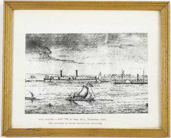 Port of Echuca
Work on paper - Framed print of a Lithograph
Small wooden frame of a Lithograph showing a river scene with 2 paddle steamers, a sailing boat and an Indigenous bark canoe on a river, with a town and a wharf in the background. The sky is cloudy. LADY AUGUSTA & MARY ANN at Swan Hill, September 1853. (By courtesy of South Australian Archives) -
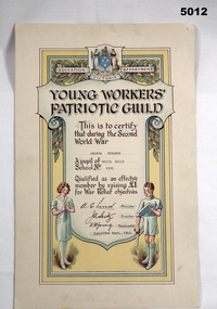 Bendigo Military Museum
Certificate, Victorian Education Department, YOUNG WORKERS PATRIOTIC GUILD SECOND WORLD WAR, c1939 - 1945
This is a cardboard colourised certificate. It was put out by Victorian Education Department. On top centre is a crest showing two women. A shield with Southern Cross, around the words "Education Dept Victoria", are garlands of gum leaves and gum nuts. At the bottom of the certificate are printed figures of a girl and boy. The girl is knitting something. The boy is holding a saw and a piece of timber. (His knees are scratched.). The recipient's details are typed - George Edwards of White Hills 1916 - Dated 22 Sep 1942.ww2, schools, fundraising -
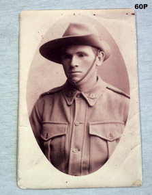 Bendigo Military Museum
Photograph - PORTRAIT PHOTOGRAPH, 1915
William Henry CHAPMAN No 1070 enlisted in C Coy 23rd Batt AIF on 2.3.1915. Embarked for Egypt 10.5.1915. Embarked for France 19.3.1916. Hospitalised 20.11.1916 with sore feet. KIA 3.5.1917. Collection re Mrs May Burns.Photo post card, in sepia tone re W H Chapman.On rear; written in pen and pencil. “18 Middlesex Road Surrey Hills William Henry Chapman”photographs - photography, aif -
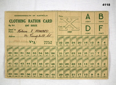 Bendigo Military Museum
Card - CARD, RATION, 1947
Commonwealth of Australia Clothing Ration card, green printed, numbered 1 - 56, 7752. On the rear in green, “The Deputy Director of Rationing, Cavendish House 159 Flinders Lane Melbourne”On front in pen, “ Kelvin E Howard 20 Campbell St”, stamped in red, “SWAN HILL”clothing ration, 1947 -
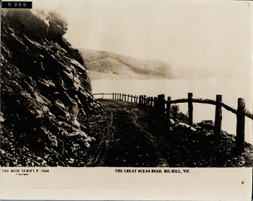 Lorne Historical Society
Postcard - Photograph of a Rose Series Postcard of Great Ocean Road, Great Ocean Road near Big Hill
Photograph of a Rose Series P 3764 showing wooden fence and bend in the G.O.R. at Big Hill g.o.r.; rose-series-postcard; big-hill; -
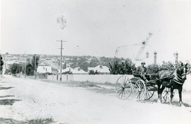 Ringwood and District Historical Society
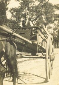
Photograph, Mr Clarence Hams in horse drawn carriage- Warrandyte Road, Ringwood. c1918
Black and white photograph"Written on back of photograph" Mr Clarence Hams in buggy at top of Kennedy's Hill - Warrandyte Road. -
 Ringwood and District Historical Society
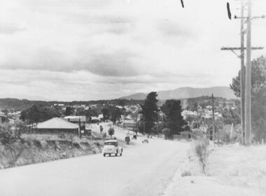
Photograph, Maroondah Highway West- Ringwood- c1949. Easterly view from Heatherdale Road along Whitehorse Road
Black and white photograph (2 large, 1 small)Written on back of photograph: "Main Street from Ringwood hill (near Heatherdale Road) c1949" -
 Ringwood and District Historical Society
Photograph, Mr. Leo Pratt. Driving down Nelsons Hill, 1927
Written on back of small photograph, "Mr. Leo Pratt. Driving down Nelsons Hill, 1927." -
 Ringwood and District Historical Society
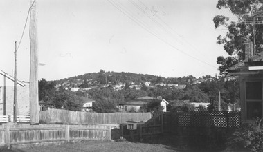
Photograph, Loughnan Hill from corner Maroondah Highway and Herbert Street, 1964
Written on backing sheet, "Loughnan Hill from corner Maroondah Highway and Herbert Street, 1964". -
 Uniting Church Archives - Synod of Victoria
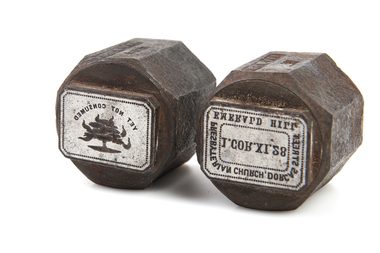
Functional object - Printing block
A015.1 and A015.2 heavy metal printing blocks in octagonal shape with rectangular stamps. 15.1 has text and 15.2 text and the burning bush.15.1 "PRESBYTERIAN CHURCH DORCAS STREET EMERALD HILL I.COR.XI.28" 15.2 "YET NOT CONSUMED"dorcas street emerald hill presbyterian church. -
 Whitehorse Historical Society Inc.
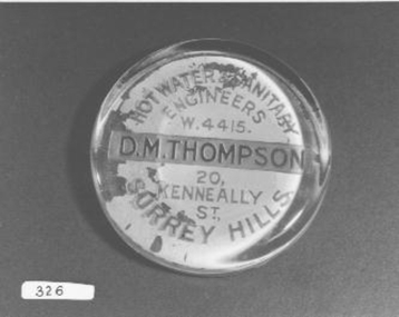
Functional object - Paperweight
Would have been used for Advertising or as gifts for customersGlass paperweight - Paper with advertising detail pasted on backHot Water and Sanitary Engineers W4415 D.M. Thompson, 20 Kenneally St., Surrey Hillscommerce, office equipment / stationery -
 Rutherglen Historical Society
Image, Barry Hill, 2/03/1997
Colour photograph of the front of the Rutherglen Common School Museum with a man walking down the driveway toward Murray StreetOn back of photo: "Taken by Barry Hill on 2-3-1997. Henry Pleming walking out."henry pleming, rutherglen common school, common school museum