Showing 2265 items
matching map collections
-
 Surrey Hills Historical Society Collection
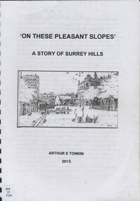
Book, On these pleasant slope's: a story of Surrey Hills, 2015
Sourced via conversations with those interested in Surrey Hills History. Including Alan Holt, Jack McLean, Frank Bamford, Jocelyn Hall. Includes: Topographical maps, first Elgar Survey. First Wesleyan Church in Surrey Hills. Bibliography on P.50 (last numbered page) Provides a chronological history of Surrey Hills. Includes: First settlers, location, early land sales, commerce and trade.Provides a chronological history of Surrey Hills. Includes: First settlers, location, early land sales, commerce and trade.Back of Title page: To the Surrey Hills Historical / Arthur E. Tonkinfreehold investment and banking company, windsor park estate, (mr) dennis delany, mont albert village, surrey hills - history, royal hotel, surrey hills, humberstone's hotel, chatham state school, holy trinity church, lydswood, lugano, (mr) john butler maling, (mr) john hanlon knipe, mont albert primary school, (mr) james sneddon, (mr) arthur tonkin -
 Surrey Hills Historical Society Collection
Book, Medlow Garden Survey and Landscape capability study 1983, Oct-83
Includes: Plan of Subdivision, Detailed plan, map of garden, Auctioneer's plan for 1854 sale, Botanical plan of Medlow & Landscape history notes. Full title : Medlow Garden survey and landscape capability survey. A report for the National Trust of Australia (Victoria) A report giving a detailed landscape survey of Medlow Garden estate. Includes landscape story, cultural significance, particulars about vegetarian, garden, rehabilitation and plans.Copy of a report giving a detailed landscape survey of Medlow Garden estate. Includes landscape story, cultural significance, particulars about vegetarian, garden, rehabilitation and plans. 38 pages with illustrations.land surveys, medlow garden, bismark estate, rosalie estate, warrigal road, surrey hills, bismarck avenue, warwick avenue, t p payne, (mr) hugh glass, boroondara, (mr) (maj) - cairncross, (mrs) mary jane cairncross, (dr) (mr) richard joseph bull, (mrs) catherine grace bull, (miss) norma bull, (mr) ronald richard bull, medlow -
 Surrey Hills Historical Society Collection
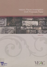
Book, Historic Places Investigation Draft Proposals Paper, 2015
Draft Proposals paper for Victorian Environmental Assessment Council's (VEAC) Historic Places investigation, written for community consultation purposes.Draft Proposals paper for Victorian Environmental Assessment Council's (VEAC) Historic Places investigation, written for community consultation purposes. colour illus. mapshistory buildings, historic sites, public lands -
 Surrey Hills Historical Society Collection
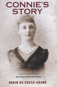
Book, Connie's Story: Commemorating the life of Mrs Edward (Plorn) Dickens, 2014
... for the Surrey Hills Neighbourhood Centre History collection. Includes... collection. Includes: illustrations, maps, portraits. Connie Dickens ...Purchased by the Surrey Hills Historical Society for the Surrey Hills Neighbourhood Centre History collection. Includes: illustrations, maps, portraits. Connie Dickens is believed to have spent some of her last year(s) in Surrey Hills. Traces the life of Mrs Edward (Plorn) Dickens, born in 1859 at River-View, Kangaroo Point, Tasmania, the third daughter of Alfred and Emily Desailly (nee Stanfield).Traces the life of Mrs Edward (Plorn) Dickens, born in 1859 at River-View, Kangaroo Point, Tasmania, the third daughter of Alfred and Emily Desailly (nee Stanfield).(mrs) constance emily rose dickens, (mrs) edward (plorn) dickens, (dr) (mr) francis desailly, (mr) alfred desailly, (miss) constance emily rosa desailly, (miss) emily desailly, (miss) florence eva desailly, (mrs) (ann) nancy sophia desailly, box hill cemetery -
 Surrey Hills Historical Society Collection
Book, Medlow Garden Survey and Landscape capability study 1983, Oct-83
Includes: Plan of Subdivision, Detailed plan, map of garden, Auctioneer's plan for 1854 sale, Botanical plan of Medlow & Landscape history notes. Full title : Medlow Garden survey and landscape capability survey. A report for the National Trust of Australia (Victoria) A report detailing the landscape survey of Medlow Garden estate. Includes landscape history, cultural significance, particulars about vegetarian, garden, rehabilitation and plans.A report detailing the landscape survey of Medlow Garden estate. Includes landscape history, cultural significance, particulars about vegetarian, garden, rehabilitation and plans. 38 p illland surveys, medlow garden, bismark estate, rosalie estate, warrigal road, surrey hills, bismarck avenue, warwick avenue, t p payne, (mr) hugh glass, boroondara, (maj.) (mr) - cairncross, (mrs) mary jane cairncross, (dr)(mr) richard joseph bull, (mrs) catherine grace bull, (miss) norma bull, (mr) ronald richard bull, medlow, house names, (mr) rex swanson, landform australia -
 Surrey Hills Historical Society Collection
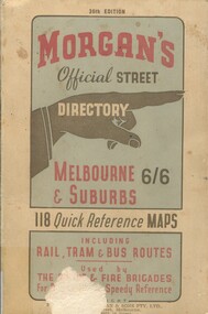
Book, Morgan's Official Street Directory, c1940s
incl.index. This Street Directory of Melbourne and suburbs, c1940s, includes a list of suburbs, their mileage from the city and how to reach them; an index to localities as well as the index to streets appearing on the maps. It also shows bus routes, railways and tramways routes on the maps.incl.index. This Street Directory of Melbourne and suburbs, c1940s, includes a list of suburbs, their mileage from the city and how to reach them; an index to localities as well as the index to streets appearing on the maps. It also shows bus routes, railways and tramways routes on the maps.melbourne metropolitian area, suburbs, cities and towns, maps -
 Surrey Hills Historical Society Collection
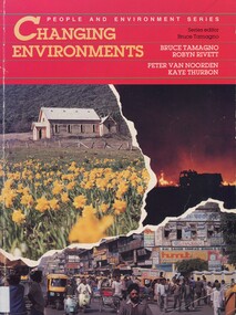
Book, Changing environments, 1990
There is a chapter dedicated to the physical and built environment of Surrey Hills and surrounding area. It includes maps drawn from the work of Alan Holt. The late Robyn Rivett (Rhodes) taught geography before becoming a curriculum adviser within the Education Department. She lived in Surrey Hills.Surrey Hills Neighbourhood Centre - historyhuman ecology, anthropo - geography, (mr) bruce tamango, people and environment series, streetscapes, (mrs) robyn rivett, (mrs) robyn rhodes, (mr) alan holt, surrey hills -
 Surrey Hills Historical Society Collection
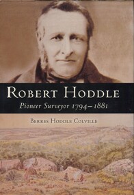
Book, Robert Hoddle: pioneer surveyor 1794-1881, 2004
(Ms) Berres Hoddle Colville is a local Surrey Hills resident and is a descendant of Robert Hoddle. Robert Hoddle was the first Surveyor General of Victoria. He arrived in Australia in 1823 and was one of the very earliest surveyors to explore, measure and map large areas of this vast, varied and difficult countryside, in a burgeoning era of pastoral settlement. 1837 saw him appointed Surveyor in Charge of the Port Phillip District. This book is based firmly on substantial extracts from Hoddle's own diary and other writings. Includes black and white sketches, maps and colour pages.Robert Hoddle was the first Surveyor General of Victoria. He arrived in Australia in 1823 and was one of the very earliest surveyors to explore, measure and map large areas of this vast, varied and difficult countryside, in a burgeoning era of pastoral settlement. 1837 saw him appointed Surveyor in Charge of the Port Phillip District. This book is based firmly on substantial extracts from Hoddle's own diary and other writings. Includes black and white sketches, maps and colour pages.Front endpaper: SURREY HILLS HISTORICAL / SOCIETY / PURCHASED FROM / THE AUTHOR ON THE OCCASION / OF HER TALK ON ROBERT HODDLE / TO THIS SOCIETY ON 17-10-[20]05 Title page: signed by the author: Berres Hoddle Colville / 17 October 2005 /(mr) robert hoddle, surveyors, (ms) berres hoddle colville -
 Federation University Art Collection
Painting - Acrylic on Linen, 'Tingari Cycle' by Walala Tjapaltjarri
Walala Tjapaltjarri (b. c1960) Language: Pintupi Region: Kiwirrkuru In late 1984 Walala Tjapaltjarri and several other members of the Pintupi Tribe walked out of the remote wilderness of the Gibson Desert in Western Australia and made contact for the first time with European society. Described as 'The Lost Tribe', he and his family created international headlines. Until that day in 1984, Walala and his family lived the traditional and nomadic life of a hunter-gatherer society. Their intimate knowledge of the land, its flora and fauna and waterholes allowed them to survive, as their ancestors had for thousands of years. It is this sacred landscape, and its significant sites, that Walala so strikingly describes in his paintings. His style is generally highlighted by a series of rectangles set against a monochrome background. He paints the Tingari Cycle (a series of sacred and secret mythological song cycles) which are associated with the artist's many dreaming sites - they are Wilkinkarra, Maruwa, Tarrku, Njami and Yarrawangu, to name a few. These Dreamings are the locations of significant rockholes, sandhills, sacred mountains and water soakages in the Gibson Desert. (http://www.kateowengallery.com/artists/Wal90/Walala-Tjapaltjarri.htm, accessed 18 May 2015) Walala Tjapaltjarri started painting in 1997. His earliest works were in a classical Tingari style usually reserved for body painting, ground painting and the decoration of traditional artifacts. Within a couple of months his painting had evolved into his own innovative style of work, including the abstraction of classical Pintupi designs which resulted in a highly graphic language to speak of his country and ceremonial sites. The rectangles so prominent in his paintings form both a physical and spiritual map establishing Walala as a discerning draughtsman for his ancient country. (http://www.kateowengallery.com/artists/Wal90/Walala-Tjapaltjarri.htm, accessed 18 May 2015) This item is part of the Federation University Art Collection. The Art Collection features over 1000 works and was listed as a 'Ballarat Treasure' in 2007.Tingari Cycle - During the Tjukurrpa (Creation Era) Tingari ancestors beings gathered at a series of sites for Malliera (Initiation) Ceremonies. They travelled vast stretches of the country, performing rituals at specific sites that in turn created the diverse natural features of the environment. The Tingari men were accompanied by novices and usually followed by Tingari Women. The creation stories and rituals are venerated in the song cycles and ceremonies of today, forming part of the teachings of the post initiatory youths, whilst also providing explanations for contemporary customs. Walala Tjapaltjarri uses a highly personalised and minimal style to represent aspects of the sacred Tingari Cycle, an epic journey of Ancestors of the TJukurrpa (Creation Era). He paints aspects of the Tingari Cycle which are associated with the artist's many sacred sites - such as Wilkinkarra, Maruwa, Tarrku, Njami and Yarrawangu, to name a few. These are locations of significant rockholes, sandhills, sacred mountains and water soakages in the Gibson Desert. (http://www.kateowengallery.com/artists/Wal90/Walala-Tjapaltjarri.htm, accessed 18 May 2015)art, artwork, walala tjapaltjarri, aboriginal, dreaming, creation era, acrylic on linen, pintupi, kiwirrkuru, tingari, wilkinkarra, tarrku, njami, yarrawangu -
 Federation University Art Collection
Artwork, other - Handcut & Collaged maps on paper, 'Survey Vessel I' by Carole Wilson, 2008
Carole WILSON (1960- ) Born Canberra, Australia Carole Wilson undertook undergraduate studies at the Canberra School of Arts and Phillip Institute of Technology. She completed a Graduate Diploma in Education at the University of Ballarat in 1987, and a Doctor of Philosophy in 2000. She has chosen central motifs in her work, which she incorporates throughout a series. The urn has been a unifying motif in Wilson's map work and testifies to the way in which function drives form across cultures. Carole's work is held in many public collections including the National Gallery of Australia, the Powerhouse Museum, State Library of Victoria and a number of regional Victorian galleries. Her posters are in museum collections in Finland, Moscow and Poland. In 2001 Dr Wilson was awarded a Doctor of Philosophy (Visual Art) from the University of Ballarat (Now Federation University). She graduated with a Graduate Diploma in Education from University of Ballarat in 1987, and a Diploma of Art from the Phillip Institute of Technology (RMIT) in 1984. Carole Wilson lectures at Federation University Australia: 2010- Senior Lecturer in Visual Arts, Honours and Research Degrees Co-ordinator 2009-2011 Lecturer in Studio Practice and Postgraduate Co-ordinator 1999-2008 Lecturer in Visual Arts (Sessional) This item is part of the Federation University Art Collection. The Art Collection features over 2000 works and was listed as a 'Ballarat Treasure' in 2007. Donated through the Australian Government's Cultural Gifts Program by Anne M. Drum, 2011art, artwork, carole wilson, maps, urn, alumni, available, staffmember -
 Federation University Art Collection
Work on paper - artwork, Susanna Castledon, 'Untitled' by Susanna Castledon
Susanna CASTLEDON (1968 - ) Born London, England Arrived Australia 1977 This item is part of the Federation University Art Collection. The Art Collection features over 2000 works and was listed as a 'Ballarat Treasure' in 2007.parallel prints, printmaking, map, susanna castledon -
 Federation University Art Collection
Print, 'Collagraph 3' by Carole Wilson, 2007
Carole WILSON (1960- ) Born Canberra, Australia Carole Wilson undertook undergraduate studies at the Canberra School of Arts and Phillip Institute of Technology. She completed a Graduate Diploma in Education at the University of Ballarat in 1987, and a Doctor of Philosophy in 2000. She has chosen central motifs in her work, which she incorporates throughout a series. The urn has been a unifying motif in Wilson's map work and testifies to the way in which function drives form across cultures. Carole's work is held in many public collections including the National Gallery of Australia, the Powerhouse Museum, State Library of Victoria and a number of regional Victorian galleries. Her posters are in museum collections in Finland, Moscow and Poland. In 2001 Dr Wilson was awarded a Doctor of Philosophy (Visual Art) from the University of Ballarat (Now Federation University). She graduated with a Graduate Diploma in Education from University of Ballarat in 1987, and a Diploma of Art from the Phillip Institute of Technology (RMIT) in 1984. Carole Wilson lectures at Federation University Australia: 2010- Senior Lecturer in Visual Arts, Honours and Research Degrees Co-ordinator 2009-2011 Lecturer in Studio Practice and Postgraduate Co-ordinator 1999-2008 Lecturer in Visual Arts (Sessional) This item is part of the Federation University Art Collection. The Art Collection features over 2000 works and was listed as a 'Ballarat Treasure' in 2007. Carole Wilson lectures at Federation University Australia: Framed collograph by Carole Wilson. art, artwork, wilson, carole wilson, available -
 Federation University Art Collection
Painting - Artwork, [Untitled]
Under the direction of lecturer Raymond Thomas five students of Koorie Studies at the Gippsland Centre for Art and Design created this work. The were Vickie Turvey, Robyn Yates, Kellie Parsons, Melissa Fenton, Deanna Mobourne.A large canvas with indigenous plants, and Aboriginal animal motifs. If you can assist with information about this artwork, or the artist, please use the comment box below. artwork, artist, gippsland campus, aboriginal, kangaroo, emu, fish, clan map, vickie turvey, robyn yates, kellie parsons, melissa fenton, deanna mobourne, koorie studies -
Federation University Art Collection
Printmaking - Collograph, Fusea, Janine, The Map is in the Brain
This item is part of the Federation University Art Collection. The Art Collection features over 1000 works and was listed as a 'Ballarat Treasure' in 2007.art, artwork -
 Port Fairy Historical Society Museum and Archives
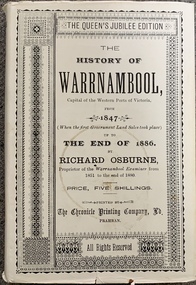
Book, Richard Osburne, The history of Warrnambool, capital of the western ports of Victoria, from 1847 (when the first government land sales took place) up to the end of 1886, 1980
The history of Warrnambool, capital of the western ports of Victoria, from 1847 (when the first government land sales took place) up to the end of 1886 / by Richard Osburne Other Authors, Fraser, Malcolm, 1930-2015, (author of introduction, etc.) Tylee Memorial Collection368 pages, unnumbered and folded leaves of plates : illustrations (some colour), maps, portraits, plans ; 19 cmnon-fictionThe history of Warrnambool, capital of the western ports of Victoria, from 1847 (when the first government land sales took place) up to the end of 1886 / by Richard Osburne Other Authors, Fraser, Malcolm, 1930-2015, (author of introduction, etc.) Tylee Memorial Collectionvictoria. warrnambool, 1847-1886. facsimiles, government policy - initial period and protectionism., settlement and contacts - 19th century., mining industry - gold., race relations - violent - massacres, religions - christianity - missions., warrnambool (vic.) -- history., framlingham / purnim (w vic sj54-11), demography - census data, book -
 Federation University Art Collection
Artwork, other - Artwork, 'Ghosts in the Himalayas (Shot Up)' by Lisa Anderson, 2016
Dr Lisa ANDERSON (1958- ) Dr Anderson’s research questions environmental issues that impact on the social structures of communities and their mapped or metaphysical borders. She develops projects around ways of understanding the effects of climate change. These include work with folklore, legends and religions that tell stories of coping with weather, forced migration of animals and people and coping with difference. She has undertaken international residency programs and exhibitions in the Arctic, Iceland, Paris, Norway, London and China, and she was the first Artist in Residence at the Australian Museum. These unique opportunities continue an extensive art practice of installation work, video, photography and sculpture. Anderson has an extensive record of exhibitions in Australia and overseas with work included in both private and corporate collections. Her exhibitions include Journeys: Due North, a large installation work that includes work created over a 10-year period of engagement in expedition and science work North of the Arctic Circle. Beneath the Beauty of Architecture, an exhibition at her London Gallery, Bicha, used images created in China, Nunuvut Territory in Canada and the Antarctic while working with the migration stories of survival. Dr Anderson has created many large scale artworks that challenge notions of occupation of the City, including Writing the City, a three-year program of installation works to shift the use of Sydney to being a city of public space in its pre-Olympic development. Singing up Stones celebrated the people who created and use the Opera House and the Quay for performance and ideas. This included the first image projection onto the Sydney Opera House, a projection onto the Sydney Harbour Bridge and a ballet of cruise liners with the sound simulcast on the local radio station. Two digital prints with acrylic on metal and bullet holes. This work is the result of research on the hidden voice of landscape undertaken by Dr Lisa Anderson while an Honorary Professor at Federation University Australia. lisa anderson, available -
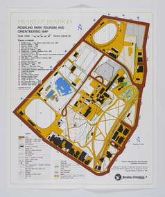 City of Greater Bendigo - Civic Collection
Map - Rosalind Park and surrounds
city of greater bendigo tourism, rosalind park, faith leech memorial swimming pool, city of greater bendigo events -
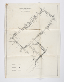 City of Greater Bendigo - Civic Collection
Document - Set of correspondence re Queen Elizabeth tour of Bendigo, Mrs T. R. Mannix, February 8th, 1954
Correspondence between Mrs T. R. Mannix, Swan Hill Wolf Cub Pack master to District Scout Commissioner Mr J. I. Samson for an invitation to be included with the local scout groups in functions to welcome Queen Elizabeth and the Duke of Edinburgh to Bendigo on Friday, the 5th of March 1954. The response from the Commissioner included typed plans of the event and maps of the royal tour through the streets of Bendigo starting and finishing at the train station.Set of correspondence including typed gatefold letter, typed plans for placement of visitors and role of the military and maps of CBD Bendigo and of Upper Reserve.queen elizabeth, duke of edinburgh, boy scout association, mayor clayton, city of greater bendigo royal visits, city of greater bendigo community groups, city of greater bendigo tourism -
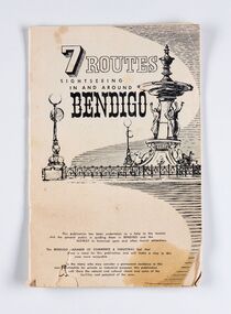 City of Greater Bendigo - Civic Collection
Booklet, J. W. H Publications, 7 Routes. Sightseeing in and around Bendigo, c 1950
A publication promoting visitation and automobile touring around Bendigo and surrounding districts. Suggests seven routes and contains extensive advertising for accommodation, businesses and services within Bendigo and Castlemaine.Thirty two page tourist fold out booklet containing maps and directions for half day and day routes in the district. Booklet also contains advertising promoting Bendigo and District businesses. city of greater bendigo commerce, city of greater bendigo tourism, making a nation exhibition -
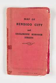 City of Greater Bendigo - Civic Collection
Map, Bolton Brothers Printers, Map of Bendigo City and Eaglehawk Borough Streets, Unknown
Produced by local company Bolton Brothers. Suitable for the glove box of car.Fold out map with a book style red and black printed front and back cover. Includes a three page index of street names and reference points. city of greater bendigo commerce, city of greater bendigo tourism -
 City of Greater Bendigo - Civic Collection
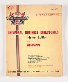
Book, Universal Business Directories, Universal Business Directory for Bendigo, c 1950
Business Directories such as this were common right up until the widespread use of the internet and search engines such as Google to find information. Universal Business Directories were a company which sought advertisers from local areas to offset the cost of producing the directories. This directory includes a history of Bendigo, map and recipes as well as extensive listings for local business, trades and services. 50 page, three colour commercially printed business directory designed to by hung beside the telephone. Includes advertising and listings for a wide variety of local businesses. Includes a page of recipes and information for emergency services. city of bendigo, city of bendigo commerce -
 City of Greater Bendigo - Civic Collection
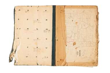
Administrative record - Land Sales, A. J. Mullet Government Printer et al, 1927
This type of album was made by agents auctioning and selling land.Large portfolio style album with dark green / black cloth cover bound with three large metal pins. Forty eight pages with twenty seven Department of Lands and Survey maps and newspaper clippings about land sales and auction details pasted in. Index page. Maps have handwritten notes and markings throughout in pencil and pen. Covers the County's of Gunbower and Tatchera. Includes a receipt slip with hand written notes on reverse on William Wallace & Co letterhead. city of bendigo commerce -
 City of Greater Bendigo - Civic Collection
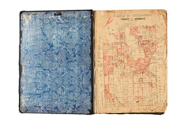
Administrative record - Land Sales, Department of Lands and Survey et al, 1929
This type of album was created by agents auctioning and selling land.Large portfolio style album with green cloth cover bound with three large metal pins. One hundred and then pages with thirty three Department of Lands and Survey maps pasted in. Index page. Maps have handwritten notes and markings throughout in pencil and pen. Covers the Counties of Bendigo, Rodney, Talbot, Gunbower, Gladstone, Tatchera and Karkarooc, Shires of East Loddon and Huntly and Swan Hill District. -
 City of Greater Bendigo - Civic Collection
Administrative record - Land Sales, A. J. Mullet Government Printer, 1927
This type of album was created by agents auctioning and selling land.Large portfolio style album with black cloth cover bound with three large metal pins. Blue marbled pastedown endpapers. Seventy nine pages, seventy five with Department of Lands and Survey maps attached. No index page. Maps have handwritten notes and markings throughout in pencil and pen. Covers the Counties of Bendigo, Rodney, Gladstone and Talbot and Parishes of Kerang, Salisbury, Mandurang and Tarnagulla. Includes a hand written note on William Wallace & Co letterhead. city of bendigo commerce -
 City of Greater Bendigo - Civic Collection
Booklet, Cambridge Press, City of Bendigo Handbook 1978, 1978
Handbook for residents with information about rates, garbage collection, numbering houses, building, dog registration etc.Black and white printed, seven page handbook for residents. Centre page illustrated map. Front cover; photo of Sacred Heart Cathedral. Handbook is folded in centre. Stapled on fold. councillor r turner, mayor turner, city of bendigo -
 Friends of Ballarat Botanical Gardens History Group
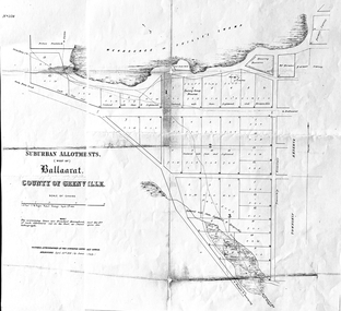
Work on paper - Suburban Allotments (west of) Ballaarat, Wendouree or Yuille's Swamp, County of Grenville 30/4/1856, 30/4/1856. No date given for photocopy
This map of the 1856 survey shows the numbered suburban allotments and the boundaries surrounding this area including Wendouree or Yuilles's Swamp close to where the Ballarat Botanical Gardens and the Lake exist today. This map gives a clear idea of an early survey of this western area and directions to areas of Ballarat surrounding these allotments.2 pages of the same map, except p.2 shows the Township Reserve on the lefthand side of the page. On the back of p.2, righthand corner is the Public Records Stamp.P2, righthand corner is the citation in pencil.john garner, doctor john garner, ballarat botanical gardens, friends of ballarat botanical gardens, map of western suburban allotments 1856, county of grenville, public record office of victoria, john garner collection, gardens, ballarat -
Friends of Ballarat Botanical Gardens History Group
Work on paper - Victoria Park Precinct, City of Ballarat, Victorian Heritage Database place details -19/9/2017, 19/9/2017
Victoria Park is associated with gold mining in the 1860's, military manoevres in the late 19th century; as an army base during World War 2 and a recreation area.Victoria Park is a "landmark cultural landscape" in the city of Ballarat. This parkland established 1890-1910, was modelled on English country estates and London Parks. It demonstrates the civic pride of Ballarat citizens and is an important parkland for the local community. There is a collection of exotic and early planted native trees and areas of native grasslands.6 pages of print. p.1. is a front page with a map and Victoria Park marked in purple with a bibliography on p.4 and footnotes on p.6.None.john garner, victoria park, friends of ballarat botanical gardens, heritage overlay, gold mining, parkland, late nineteenth century, native grasslands, exotic and native trees, royal park, mullock heap, mount holled-smith, arbor day, messrs clegg&nicholls, william guilfoyle, w.o.allen, significant tree register, john garner collection, gardens, ballarat -
 Friends of Ballarat Botanical Gardens History Group
Map - Map of Trees in the Ballarat Botanical Gardens, Tree Research - Location Plan and Naming, 1983
john garner collection, ballarat botanical gardens, gardens, ballarat, trees, map, 1983 -
 Melton City Libraries
Map, Streets of Melton, 1963
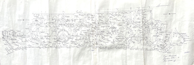
... Street Streets of Melton Map Barrie Collection ...MELTON’S STREETS Heritage Week 2014 What’s in a Name? Alphabetical List Aboriginal place names, Early Family Names and landowners, Agricultural, Shop and Commercial premises, Places and Events Melton & District Historical Society Street Naming Project 1972 – c 1998 Suburb Name – KURUNJANG - Kirkton, 1972, Brookfield, West, 1988 Melton and Town Centre - A joint collaboration with the Shire of Melton and Subdivision Developers ARNOLD Court – Family house - Arnolds Creek ALKEMADE Drive Family – Lime kilns Coimadia ALEXANDRA Street 1902 – Corination of King Edward VII and Queen Alexandra AVIATOR Place Event, location of plane crash – Jimmy Melrose 1936 Adina ?Annibee - Anniba? Agricultural Avon court .. .. BAKERY Square - Location of Jongebloed shop, bakehouse and stables BALUK Place Aboriginal BARLEYCORN Place Agricultural BILLING Place Name of Jimmy Melrose Uncle Noel Pemberton Billing BLACKWOOD Drive - Alexander Blackwood 1860c Registrar BARRIES Road C. E. Barrie “Darlingsford” farmer 1911, chaff mill owner BROOKLYN Road Staughton family residence. 1875 – Dismantled c 193? CAHILL Drive Family - Glenville Dairy CAMERON Court Family Canopus Place ? CANALLAN Drive Early Surveyor CAMPBELL Court Aviation – Melrose passenger 6th July 1936 CARBERRY Drive Michael, early landowner family CAREW Court Edward and Michael. Royal Hotel. Vera (Carew) Forran Singer - Opera CASEY Court Family CASHIN Court Family CHEVIOT Court Agriculture, breed of sheep CHESNEY Road was re named ( Minns Road being duplicated c 1973) CHRISTINA Crescent Christina McPherson, daughter of James and Mary Mary McPherson. Died 1955 aged 85 years COLLYER Close a deleted street (parallel to Yuille) re-used CORRIEDALE Road Breed of sheep CORR Court Teacher at first school, landowner CROXTON Court Name of the Hornbuckle and Knox family home DALEY Court - William Daley and family 1865 Bootmaker High Street DARLINGSFORD Boulevard - Name of early homestead Thomas B Darling 1853 DJERRIWARRH Court - Parish County of Bourke - very early map. DODEMAIDE Place Early land owners - Melton Football Team had 6 brothers playing c 1924 DONALD Court McPherson family 6 generations in Melton in 1936 DOUGAL Court DUNCAN Court .. .. DUNVEGAN Circuit Home of the McPherson family, castle Isle of Skye Name of bluestone house Smith Street (now at Willows) EMIL Court Jongebloed family EXELL Avenue Farming family Melton Sth- Closer Settlement 1907 EXFORD Road Exe former name of the Werribee river FARMER Court Name of early postmistress FERRIS Road John Ferris Farmer HANNAH Close First name of Hannah Watts – midwife HAYBALE Place Agricultural HELDER Court Early surveyor J Helder Wedge map HEWSON Street Winston Hewson Shire Engineer – check title c 1960 HENRY Street Township map c 1860 HESTON Street Heston Phoenix – C.J. Melrose plane HILDEGARDE Court Jimmy Melrose’s mothers name HOMESTEAD Close HORNBUCKLE Cres Farmers. Three members of family - Shire Presidents HURLEY Street Farmers IAIN Court Descendent of James and Mary McPherson JAMES MELROSE Drive Name appears on 2013 Melton information map JANG Place KURUN – jang KIRKTON Drive Name of the McPherson family home Toolern Vale Road KIRWIN Street Michael early landowners (deleted for freeway construction) KILPATRICKS Road Deleted when Barries Road was extended across Station Rd KOROROIT Court Early map, Parish of Kororoit. Creek name KNOX Circuit Family – Hornbuckle “Croxton Park” KURRUNJANG Drive Aboriginal name for people of the red earth – Suburb name Lara Place ? LLOYD Court Garage owners High Street. Laura lived to 100 years D 1955 LUBY Court John Luby – Crown Grant Land Title LITTLE Court MANNING Avenue Richard, hotel owner 1891 MARGARET Drive McPherson family McDONALD Street Melton South family name McKENZIE Street Township c1860 MORROW Street Early name MOWBRAY Crescent Name of English Melton, popularly believed origin of Melton MYERS Court Early setters c 1866 Crown Grant Land Title NIMMO Street Early name NIXON Street Name submitted by Mary nee Nixon Collins c1985 OLDERSHAW Road Early builder PALMERSTON Street Early township map c 1860 PEART Court Early name PENNYROYAL Avenue Plant growing by the creek. Early name used for the Toolern Toolam Creek PINKERTON Street Family name and early street map PINNACLE Crescent Agricultural - type of wheat PHOENIX Circuit C.J. Melrose Phoenix Heston Plane 2013 map PRATT Family PRIOR Court PYKE Place Brothers – early settlement 1838 RADFORD Court Land owners and business operators. Former Royal Hotel Grocer High Street demolished 1970 RAGLAN Court Hotel 19th century Lord Raglan RALEIGHS Road Oliver Reierson family (Norweigen) Shopkeeper – Dressmakers RIDDELL Drive (misspelt Riddle) Resident and land owner RODERICK Road McPherson family – a re occurring name ROLLAND Court Jones family ROSS Court Daniel. Landowner. Agnes Ross music teacher RUSSELL Court Robert. Early land surveyor of Melton 1853 RYAN Court Family early landowner. Member of the 1862 Road Board SHEBLER Place Augustus early Melton resident – Golden Fleece Hotel SHEEPFOLD Court Farming SHERWIN Court Sherwin Street earliest Township map– became Golf course SMITH Street Early township map. STRATHULLOH Circuit Strathtulloh Homestead. STAUGHTON Street Family – LARGE land owners Strachan ? SWANEY Court Marie Swaney earlier resident of Strathtulloh. SUTHERLAND Family name TOOLERN Street TOOLAM – TOOLERN Creek TULLIDGE St Road marked on 1861 map UNITT Street Early Township c 1860 WALLACE Square Cr Jack Wallace 5 terms as President 46 years unopposed WATTS Court Hannah Watts – midwife, cottage hospital WALSINGHAM Name of house of Minns family. From Walsingham Norfolk England WESTLEY Place Name of Jimmy Melrose Percival Gull Plane WESTLAKE Drive Early resident WHICKHAM Street Family Name Melton South WILSON Road Albert, Melton South YUILLE Street William Cross, early landowner, Rockbank run Zoomed in section of Melton Streets including Church and High Streetlandscapes of significance -
 Melton City Libraries
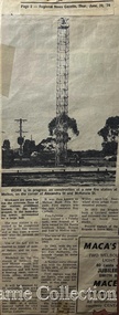
Newspaper, Melton Fire Station, 1974, 1975
In 1975 the Melton Fire Station opened in McKenzie Street. In the 1950s with the introduction two-way HF and later VHF very high frequency radio sets. Melton Rural Fire Brigade was part of the Bacchus Marsh Group. Radio sets where located in the Melton Fire Truck, and in the house of the Barrie family at Ferris Road. This was an ideal location to observe a 360 degree view in all directions when smoke appeared on the horizon. An antenna was erected beside the house. The set OX 7 was located in the kitchen and monitored 24 hours by the family. When an electrical fire occurred at the junction of the electricity to the house there was time to radio the fire station and summons the men working in the paddocks, thus saving the house from possible destruction. With the introduction of UHF – ultra high frequency Vinten Radios the signal was clearer and static and interference lessened and radio traffic became easier to read, and reduced noise levels in the household. In 1974 when the family moved to First Avenue, another antenna and a small building were erected adjacent to the residence and used to house the equipment, maps. Radio traffic consisted of regular schedule times and communication with adjoining groups of brigades such as Bacchus Marsh, Mt Macedon and Little River Groups. Many of the brigade and group base radios were situated in private residences and operated primarily by fire fighters wives who held the position of Communications Officer, either registered as a brigade member or informally.Regional News Gazette article about the construction of a new fire station in Melton and an Express article with brigade members at the opening of the station.emergency services