Showing 28492 items
matching street street
-
 Kew Historical Society Inc
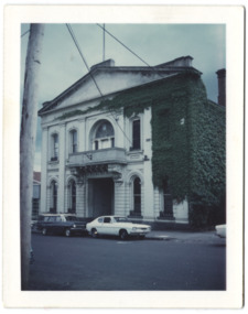
Photograph - Former Kew Town Hall, Walpole Street, 1972
... Former Kew Town Hall, Walpole Street...kew town hall -- walpole street... Street until it was moved to the new Civic Centre on the corner... of the (former) Kew Town Hall in Walpole Street between High Street... in the former Town Hall in Walpole Street until it was moved to the new ...The Municipality of Kew was granted independence in 1860. It was declared a borough in 1863, a town in 1910 and a city in 1921. In 1994, Kew was amalgamated into the new City of Boroondara. In 1960, a new Town Hall in Cotham Road was opened. The Municipal Offices that had remained in the former Town Hall in Walpole Street until it was moved to the new Civic Centre on the corner of Cotham Road and Charles Street in 1972.This is a rare and important colour photograph of the Kew Municipal Offices (former Town Hall) taken on 11/2/1972 in the year that the building was demolished and replaced by a Safeway Supermarket.Colour photographic positive (polaroid) of the front of the (former) Kew Town Hall in Walpole Street between High Street and Malmsbury Street, on the west side where Woolworth's supermarket now stands. The photograph, taken in February 1972, shows the detailing of the Italianate rendered-brick facade, added in the 1880s when the hall was renovated. The earliest building on the site was the Kew Athenaeum Hall (built 1860) which was purchased by Kew Council in 1865. The Town Hall was sold to Woolworth's and subsequently demolished in 1972 when the civic offices were transferred to a new building on the corner of Charles Street and Cotham Road.kew town hall -- walpole street, local government -- kew, town halls -- melbourne (vic.) -
 Kew Historical Society Inc
Photograph - Denmark Street, Kew, 1972
... Denmark Street, Kew...denmark street -- kew (vic.)... of automobiles and buildings in Denmark Street, Kew, immediately before... as an important record of local streets, public works, street ...The Engineer's Department of the former City of Kew had an extensive collection of photograph of sites in Kew requiring documentation to inform public works. It also kept images of engineering practice in other parts of Melbourne, and overseas, that could be used as models for local activity. Many of these photographs (and plans) were donated to our collection in the 1980s. A number of the photographs are annotated, either on the image itself or on the reverse.This photograph, and others sourced from the City Engineer's Department of the former City of Kew, qualifies as an important record of local streets, public works, street beautification, and engineering techniques of the period. Original black and white photographic positive of automobiles and buildings in Denmark Street, Kew, immediately before the road enters Kew Junction. On the left is McKeon Motors and a retailer of Insulwool, while in the distance is the pharmacy on the corner of High Street and Princess Street (later demolished during the widening of Kew Junction). Notable are the bluestone guttering and what appears to be vacant land on the apex of the triangle of land bounded by High Street South, Denmark Street and Barkers Road. This site was the original location of O'Shaughnessy's 'Kew Hotel', and after the destruction by fire of the latter, the location of a service station. [It is now the site of the Cresco Reserve].Annotation verso: "Indicating the existence of a vehicular entrance at Denmark St abuttal of No.188 High St prior to reconstruction of channeling &c 1972."denmark street -- kew (vic.), kew junction, luestone gutters, mckeon motors, insulwool -
 Federation University Historical Collection
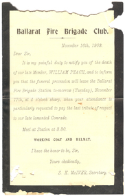
Document, Ballarat Fire Brigade Club mourning notification, 1903, 16/11/1903
... of Sturt Street and Raglan (North) Street .... The Ballarat West Fire Brigade was built on the corner of Sturt Street ...The Ballarat West Fire Brigade was built on the corner of Sturt Street and Raglan (North) Street .Black edged printed notification of the death and funeral of William Peach from S.K. McIvor, Secretary of the Ballarat Fire Brigade Club on 16 November 1903.Ballarat Fire Brigade Club November 16th, 1903 Dear Sir, it is my painful duty to notify you of the death of our late member, WILLIAM PEACH, and to inform you that the funeral procession will leave the Ballarat Fire Brigade Station to-morrow (Tuesday), November 17th, at 4 o'Clock sharp, when your attendance is particularly requested to pay the last tribute to our late lamented Comrade Meet at Station at 3.30 Working coat and Helmet I have the honor to be, Sir, Yours obediently, S.K. McIver, Secretaryballarat west fire brigade, ballarat fire brigade, fire brigade, william peach, s.k. mcivor, mourning, death -
 Ringwood and District Historical Society
Pamphlet - Land Sales Brochure, Miller's Estate , Heathmont
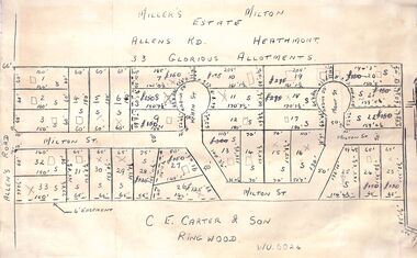
... of the Miller's Estate, Allens Road, Heathmont. The new street is Milton..., Heathmont. The new street is Milton Street with new courts Heath St ...Land sales pamphlet with hand-drawn 33 allotments of the Miller's Estate, Allens Road, Heathmont. The new street is Milton Street with new courts Heath St and Mont St. Sold by CE Carter & Son, Ringwood WU6024. Maybe circa 1950s. -
 Port Melbourne Historical & Preservation Society
Photograph - Morley's Coal Depot, Bay Street, Port Melbourne, Arthur Rowan, 1986
... Morley's Coal Depot, Bay Street, Port Melbourne... caption: Morely's Coal Depot 2 Bay Street, corner Beach Street... Melbourne Town Hall 333 Bay Street Port Melbourne melbourne ...As a member of the Port Melbourne Historical and Preservation Society, donor Arthur ROWAN photographed a series of significant buildings in the Port and South Melbourne area over several years. A selection of nineteen of these was presented to the Port Melbourne Society in 1993.Small print mounted on white card, with mounted, typed caption: Morely's Coal Depot 2 Bay Street, corner Beach Street and Post Office Place. Established 1872. First owner: William T. CLARKE [Photo from north east]built environment - commercial, arthur rowan, william t clarke, morley coal depot, william morley -
 Kilmore Historical Society
Photograph, Sydney Street Kilmore, 1880's
... Sydney Street Kilmore...2.5x1.5 inch black and white photograph of 1 Powlett street...1 Powlett Street, Kilmore, Victoria, Australia...Kilmore Historical Society 4 Powlett Street Kilmore ...2.5x1.5 inch black and white photograph of 1 Powlett street, the Court House Hotel, former colonial bank of Australasia. Corner of Powlett Street and Lancefield Road. Copy printed on card stock. Two story light coloured rendered building. The intersection of Lancefield Road, Powlett Street, Sydney Street and (modern day) Skehan Place. With a view straight down Sydney Street. One figure crossing the road.Writing on the back: PHO-00004hotels, historical towns -
 Greensborough Historical Society
Photograph - Digital image, All Saints Greensborough, 1960c
... church on the corner of Grimshaw Street and Church Street... Street and Church Street Greensborough. all saints anglican ...This photograph shows the old timber church in Greensborough - All Saint's Anglican Church - now replaced by a modern church on the corner of Grimshaw Street and Church Street Greensborough.Digital copy of colour photograph.all saints anglican church greensborough -
 Greensborough Historical Society
Photograph - Digital image, Rosemary Isaacs, All Saints Greensborough, 1960c
... church on the corner of Grimshaw Street and Church Street... Street and Church Street Greensborough. all saints anglican ...This photograph shows the old timber church in Greensborough - All Saint's Anglican Church - now replaced by a modern church on the corner of Grimshaw Street and Church Street Greensborough.Digital copy of black and white photograph.all saints anglican church -
 Clunes Museum
Photograph
... REEL AND CART ALONG FRASER STREET, CROWDS LINING THE STREET....Clunes Museum 36 Fraser Street Clunes goldfields SEE ABOVE ...SEE ABOVECOLOURED PHOTOGRAPH TAKEN 2001 DURING CELEBRATION OF THE FIRST GOLD DISCOVERY IN VICTORIA. TWO VOLUNTEER FIREMEN DRAWING REEL AND CART ALONG FRASER STREET, CROWDS LINING THE STREET.local history, photography, photographs, events and celebrations -
 Stawell Historical Society Inc
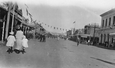
Photograph, Main Street Stawell at Easter looking West with the Post Office on the right
... Main Street Stawell at Easter looking West with the Post... with bunting hanging over the building and down the main street.... The photograph was taken at Easter celebrations in Main street looking... with bunting hanging over the building and down the main street ...Easter celebrations in Main St. Stawell. The photo is taken looking west c 1930. Post Office building is on the right with bunting hanging over the building and down the main street. The street must have been closed to traffic as people are walking up and down the street. A woman with two children are on the left of the photo. One small black & white photo and a enlarged copy. The photograph was taken at Easter celebrations in Main street looking west. A woman with 2 children either side of her on the left of the photograph. Bunting is hanging along the Main street.Main St ? Datestawell business streetscape -
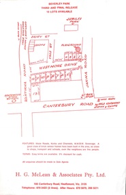 Ringwood and District Historical Society
Flyer, Land Sale Advertisement, Beverley Park, Heathmont - circa late 1970s
... Subdivision includes Wantirna Road, Daisy Street, Vale... Road, Daisy Street, Vale Street, Westmore Drive, Jarma Road ...Single sided leaflet with red printSubdivision includes Wantirna Road, Daisy Street, Vale Street, Westmore Drive, Jarma Road, Canterbury Road. Sole Agents - H.G. McLean & Associates Pty. Ltd. 166 Canterbury Rioad, Heathmont, Vic. 3135 Telephone 870 3422 (3 lines) After Hours 870 5879, 288 5071 -
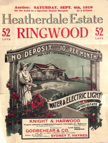 Ringwood and District Historical Society
Pamphlet - Land Auction Brochure, Heatherdale Estate, Ringwood, Victoria - 1919
... of streets and allotments, summary of local features and services... includes White Horse Road, Witt Street, Mitcham, Station Street... Street, Mitcham, Station Street (later Victory Street, Mitcham ...Double sided leaflet advertising subdivision site, layout of streets and allotments, summary of local features and services and terms of sale. Inset photographs of local views and residence of F.W. Purches on the Estate.Auction Saturday September 6th, 1919. 52 Lots. Subdivision includes White Horse Road, Witt Street, Mitcham, Station Street (later Victory Street, Mitcham). (Railway Avenue marked on the map did not eventuate). Agents - Knight & Harwood, 315 Collins Street, Melbourne in conjunction with Godbehear & Co, Phone Ringwood 49, selling through their auctioneer - Sydney T. Haynes. Solicitor W.H. Peers, 395 Collins Street, Melbourne. -
 Bendigo Historical Society Inc.
Map - LONG GULLY HISTORY GROUP COLLECTION: MAP OF LONG GULLY AREA
... Street map Long Gully/California Gully.... Street to Barrell Street. Indicators show location of the mental... Inc. History House 11 Mackenzie Street Bendigo goldfields ...map of Long Gjully and California Gully area from Craig Street to Barrell Street. Indicators show location of the mental hygiene Austhority, Agricultural Showgrounds and Recreation Reserve. The boundary between the Borough of Eaglehawk and Bendigo is shown by a dotted line along McGowan Street.eaglehawk, history, street map long gully/california gully. -
 Queen Victoria Women's Centre
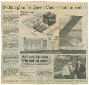
Newspaper clipping, Wayne Taylor, $600m plan for Queen Victoria site unveiled, 21 February 2001
... the works to be done on the QV block between Swanston street...Queen Victoria Women's Centre 210 Lonsdale Street Melbourne ...Unveiling of the QV plans by Groconnewspaper clipping from The Age. Graphic representing the works to be done on the QV block between Swanston street and Russell street. Black and white photo at the bottom of page of Premier Steve Bracks with director of Grocon, Daniel Grollo after the plans for QV were announced. building construction, historic building, civic centres, town planning -
 City of Ballarat Libraries
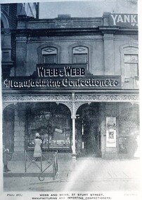
Postcard - Card Box Photographs, Webb & Webb, Manufacturing and Importing Confectioners
... Sturt Street...37 Sturt Street and 143 Sturt Street. Plates 187 & 188...City of Ballarat Libraries Eureka Centre Eureka Street ...37 Sturt Street and 143 Sturt Street. Plates 187 & 188 Chuck Photo Serieswebb & webb, sturt street, manufacturing, commerical, building -
 Eltham District Historical Society Inc
Document, Notes used by Harry Gilham at Nillumbik Council Meeting of 21 March 2000 regarding proposed sale/development of the Eltham War Memorial property, 2000
... Arthur Street, Eltham District Historical Society, Eltham... Hall in Henry Street then Arthur Street as well as Shillinglaw... Hall in Henry Street then Arthur Street as well as Shillinglaw ...Questions Council right to sell property which was gifted to them by the community and references back to the Eltham Public Hall in Henry Street then Arthur Street as well as Shillinglaw Cottage3 pages, Legal Pad, handwritten in various coloured ink pensarthur street, eltham district historical society, eltham public hall, eltham village, eltham war memorial, eltham war memorial garden, eltham war memorial trust, harry gilham, henry street, nillumbik shire council, shillinglaw cottage, stanley s addison -
 Federation University Historical Collection
Photograph - Colour Photograph, 'Ballarat and All That" at the Post Office Gallery, C2006
... The Post Office Gallery is on the corner of Sturt Street... The Post Office Gallery is on the corner of Sturt Street ...The Post Office Gallery is on the corner of Sturt Street and Lydiard Street, Ballarat and is part of the Federation University Arts Academy. Loris Button and Carole Wilson lecture in Visiual Arts. Three photographs of University of Ballarat Arts Academy students visiting the 'Ballarat and All That" at the Post Office Gallery. This exhibition highlighted important works from the University's Art Collection and was curated by Clare Gervasoni.post office gallery, carole wilson, loris button, clare gervasoni -
 Greensborough Historical Society
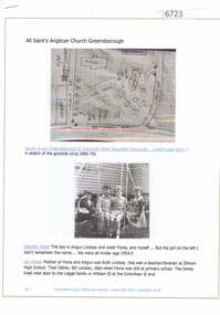
Article and Photograph, All Saints Anglican Church Greensborough, 2018_
... of the original site on the corner of Main Street and Grimshaw Street.... of Main Street and Grimshaw Street. This photograph and text ...Information and photographs of All Saints' Anglican Church Greensborough from the 1940s and 1950s. Includes a hand drawn map of the original site on the corner of Main Street and Grimshaw Street.This photograph and text was copied from a Facebook site. Members are people who lived in the Greensborough area and share their reminiscences of the area with others. The site is administered by a GHS member but is not officially affiliated with the Society. Any information is the opinion of the contributor. Article and photograph sourced from social media.all saints anglican church greensborough -
![Photograph - Digital image, All Saints Anglican Church [interior of old Church], 1950s](/media/collectors/4f729f5697f83e03086015b8/items/5940c003d0cdd715bc9c5fd7/item-media/5940c032d0cdd715bc9c7a82/item-fit-380x285.jpg) Greensborough Historical Society
Greensborough Historical SocietyPhotograph - Digital image, All Saints Anglican Church [interior of old Church], 1950s
... replaced by a modern church on the corner of Grimshaw Street...Church Street, Greensborough... of Grimshaw Street and Church Street Greensborough. all saints ...This photograph shows the interior of the original timber church in Greensborough - All Saint's Anglican Church - now replaced by a modern church on the corner of Grimshaw Street and Church Street Greensborough.Digital copy of black and white postcard.Christmas greetings written on back all saints anglican church greensborough, all saint's church of england -
 Eltham District Historical Society Inc
Photograph, Fred Mitchell, Road construction and sealing of southern end of Bible Street, Eltham, 1968, 1968
... Street, Eltham, 1968...bible street... and York streets (70 Bible Street). Next house (number 72... and York streets (70 Bible Street). Next house (number 72 ...House on left just behind truck is on corner of Bible and York streets (70 Bible Street). Next house (number 72) no longer exists, replaced by two units.Digital copy of colour photographfred mitchell collection, 1968, bible street, eltham, houses, road construction -
 Clunes Museum
Photograph
... OF BAILEY STREET AND TEMPLETON STREET, CLUNES...Clunes Museum 36 Fraser Street Clunes goldfields THE FAMILY ...THE FAMILY OF SIR JOHN LONGSTAFF MOVED TO CLUNES IN 1862. THE ORIGINAL HOME WAS NEXT DOOR TO ST-THOMAS ACQUININS CHURCH - CORNER OF BAILEY STREET AND TEMPLETON STREET, CLUNES.1 COPY PHOTOGRAPH LONGSTAFF HOME AND FAMILY .2 - .4 COPIES OF .1local history, photography, photographs, longstaff, sir john -
 Stawell Historical Society Inc
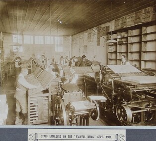
Photograph, Stawell Pleasant Creek Newspaper Staff with typesetting and printing machines in 1901
... machines in September 1901. Office at 191 Main Street Stawell. NE... machines in September 1901. Office at 191 Main Street Stawell. NE ...Stawell News Newspaper Staff typesetting and printing machines in September 1901. Office at 191 Main Street Stawell. NE Corner of Main Street and Layzell Street in 1938 -
 Eltham District Historical Society Inc
Newsletter, Newsletter, No. 218 September 2014
... by Michael Aitken • Street by Street ... by Michael Aitken • Street by Street The Shire of Eltham Historical ...Contents: • Eltham Living and Learning Centre • September Meeting • September Excursion - East of Eltham Walk • Have you discovered Trove? by Liz Pidgeon • Fabbro Farm Art Project • Eltham Library - 20th Anniversary Celebration • Henry Gilbert Jones: an early Eltham settler........and an amazing coincidence by Michael Aitken • Street by Street The Shire of Eltham Historical Society was formed in October 1967. The first newsletter of the Society was issued May 1978 and has been published continuously ever since on a bi-monthly basis. With the cessation of the Shire of Eltham in late 1994, the Society's name was revised to Eltham District Historical Society and this name first appeared with issue No. 103, July 1995. The collection of the Society's newsletters provides a valuable resource on the history of the Society's activities, office bearers and committee members, guest speakers and subjects of historical interest pertinent to the former Shire of Eltham and the Eltham District.A4 photocopied newsletter distributed to membersnewsletter, eltham district historical society, shire of eltham historical society -
 Kew Historical Society Inc
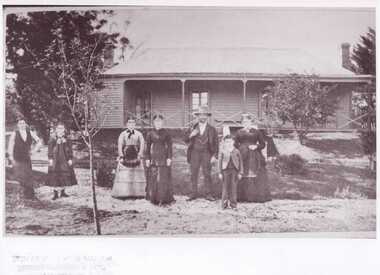
Photograph - Burgess House, Victoria Street (Abbotsford), 1880-1900
... Burgess House, Victoria Street (Abbotsford)...burgess family -- victoria street -- abbotsford (vic.).... A flood in 1901 destroyed this house in Victoria Street... it on the north side of Victoria Street, Abbotsford between Burnley Street.... A flood in 1901 destroyed this house in Victoria Street ...Major floods recurred of the Yarra River on a regular basis. A flood in 1901 destroyed this house in Victoria Street, Abbotsford. Later print copy of an original photograph. Home of C/N Burgess on the south side of Yarra River. The buildings were washed away in a flood in 1901 The house was in the same location as that on which Handley & Tilly was later built. This would locate it on the north side of Victoria Street, Abbotsford between Burnley Street and the Victoria Street Bridge. Photo shows three men and one woman working in an established garden in front of a weatherboard cottage."Home of C/N Burgess on south side of river; washed away in 1901; Handley & Tilly on site"yarra river -- floods, yarra river flood -- 1901, burgess family -- victoria street -- abbotsford (vic.) -
 Kew Historical Society Inc
Plan, Melbourne & Metropolitan Board of Works : Borough of Kew : Detail Plan No.1585, 1904
... and environmental features. Each plan covers one or two street blocks...). This plan, which covers parts of High Street, Pakington Street... features. Each plan covers one or two street blocks (roughly six ...The Melbourne and Metropolitan Board of Works (MMBW) plans were produced from the 1890s to the 1950s. They were crucial to the design and development of Melbourne's sewerage and drainage system. The plans, at a scale of 40 feet to 1 inch (1:480), provide a detailed historical record of Melbourne streetscapes and environmental features. Each plan covers one or two street blocks (roughly six streets), showing details of buildings, including garden layouts and ownership boundaries, and features such as laneways, drains, bridges, parks, municipal boundaries and other prominent landmarks as they existed at the time each plan was produced. (Source: State Library of Victoria)This plan forms part of a large group of MMBW plans and maps that was donated to the Society by the Mr Poulter, City Engineer of the City of Kew in 1989. Within this collection, thirty-five hand-coloured plans, backed with linen, are of statewide significance as they include annotations that provide details of construction materials used in buildings in the first decade of the 20th century as well as additional information about land ownership and usage. The copies in the Public Record Office Victoria and the State Library of Victoria are monochrome versions which do not denote building materials so that the maps in this collection are invaluable and unique tools for researchers and heritage consultants. A number of the plans are not held in the collection of the State Library of Victoria so they have the additional attribute of rarity.Original survey plan, issued by the MMBW to a contractor with responsibility for constructing sewers in the area identified on the plan within the Borough of Kew. The plan was at some stage hand-coloured, possibly by the contractor, but more likely by officers working in the Engineering Department of the Borough and later Town, then City of Kew. The hand-coloured sections of buildings on the plan were used to denote masonry or brick constructions (pink), weatherboard constructions (yellow), and public buildings (grey). This plan, which covers parts of High Street, Pakington Street and Derby Street is dominated by two historic Kew mansions: ‘Konetta’ and ‘Ramornie’. Ramornie was constructed in 1890 for James Maitland Campbell, three times Mayor of Kew. Sold in 1940, it became a boarding house known as ‘The Towers’. Now a private residence again, it has only one of its three balconies remaining. The location of the missing two balconies can be seen on the plan. In 1903, the grounds of Ramornie included a large tennis court fronting Pakington Street. The rear of the property is shown as extending to Cobden Street. One of Kew’s oldest hotels, the Prospect Hill Hotel on the corner of High and Cobden Street was established in 1858. The outline of the hotel shown on the plan represents the second building on the site. During the 19th century it was often used for electoral meetings. The Prospect Hill Hotel was to be redeveloped again in 1928, by the local architect Robert McIntyre. Since the 1980s, the hotel has been a live music venue, the home of the Melbourne Jazz Club, a restaurant and a liquor outlet.melbourne and metropolitan board of works, detail plans, maps - borough of kew, mmbw 1585, cartography -
 Greensborough Historical Society
Document, Judith Dodd?, Peck's Dam history, 1900o
... History of a parcel of land bounded by Bolton Street... by Bolton Street, Brougham Street, Main Road and Grand Boulevard ...History of a parcel of land bounded by Bolton Street, Brougham Street, Main Road and Grand Boulevard purchased by Mr Orr around 1900. It may have been called Panorama Heights Estate, Montmorency Park and later, Orr's Park. Orr had a dam made, which was called Peck's dam by locals in the 1940s-1950s.2p. typescriptorrs park, montmorency, pecks dam -
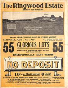 Ringwood and District Historical Society
Pamphlet - Land Auction Brochure, The Ringwood Estate - Second Sub-Division, Ringwood, Victoria - 1919
... , layout of streets and allotments, summary of local features... includes Warrandyte Road, Tamar Street, Mersey Street and Derwent.... 55 Lots. Subdivision includes Warrandyte Road, Tamar Street ...Double sided bi-fold leaflet advertising subdivision site, layout of streets and allotments, summary of local features and services and terms of sale. Auction Saturday June 14th, 1919. 55 Lots. Subdivision includes Warrandyte Road, Tamar Street, Mersey Street and Derwent Street. Property Sales - Dunlop & Hunt Home Builders Ltd., 317 Collins Street, Melbourne, Tels 10104-10105. Agents - J.B. McAlpin, Tel. Ringwood 7. Auctioneers - Sydney T. Haynes & Co., 60 Queen Street, Melbourne, Tel. 3400. Solicitors - Hodgson & Finlayson, 360 Collins Street, Melbourne. Inset photographs of local views including existing 4-roomed bungalow on Lot 37 Tamar Street. -
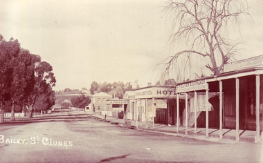 Clunes Museum
Photograph, CIRCA 1912
... .1 SEPIA POSTCARD OF BAILEY STREET, CLUNES BETWEEN SERVICE...Clunes Museum 36 Fraser Street Clunes goldfields PHOTOGRAPH ...PHOTOGRAPH TAKEN APPROXIMATELY 1912, BUILLDINGS INCLUDE ALBERT HOTEL; OLIVER'S BOOTMAKER; A POLLERD; TELEGRAPH HOTEL..1 SEPIA POSTCARD OF BAILEY STREET, CLUNES BETWEEN SERVICE STREET AND GOVERNMENT BRIDGE. INCLUDING TELEGRAPH HOTEL .2 BLACK AND WHITE REPRODUCTION OF THE ABOVE PRINTED ON MATTE PHOTOGRAPHIC PAPERlocal history, photography, photographs, shops- oliver's boot maker, a. pollerd., hotels -
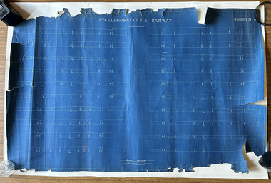 Port Melbourne Historical & Preservation Society
Plan, Pt Melbourne Cable Tramway, 1890s
... One of three sheets of blueprints showing street... crayon or pencil One of three sheets of blueprints showing street ...One of three sheets of blueprints showing street configuration in Beach Street and Sandridge Road along Port Melbourne cable tram route. Indistinguishable signature of 'George ------ Esq., lower rightNotations in red crayon or penciltransport - tramways, transport - roads -
Robin Boyd Foundation
Letter, City Engineer, 18.03.1964
... of trees in Walsh Street from Clowes Street to Domain Road....Robin Boyd Foundation 290 Walsh Street South Yarra ...Letter from J.W. Knee, City Engineer, in reply to Robin Boyd's letter (D400), denying the request for the planting of trees in Walsh Street from Clowes Street to Domain Road.