Showing 171276 items matching "streets"
-
 Ballarat Heritage Services
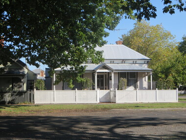
Photograph, Clare Gervasoni, House in South Street, Ballarat, 2020, 13/04/2020
Colour photograph of a house in South Street Street, Ballarat, near the intersection of Armstrong Street South.ballarat, south street, cast iron -
 Ballarat Heritage Services
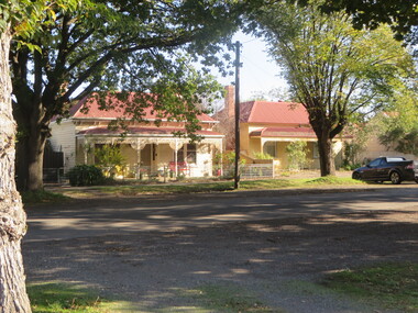
Photograph, Houses in South Street, Ballarat Central, 13/04/2020
Colour photograph of houses in South Street Street, Ballarat, near the intersection of Armstrong Street South.ballarat, south street, cast iron -
 Ballarat Heritage Services
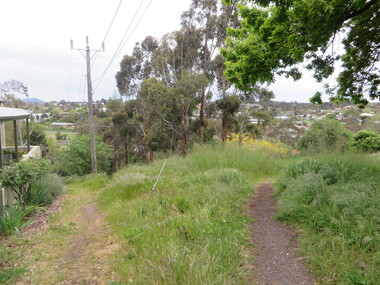
Photograph - Photograph - Colour, W Track, White Flat, Ballarat, 2016, 25/10/2016
Photographs of W-track on South Street, between Hickman Street and Armstrong Street South, Ballarat.white flat, w-track, south street, ballarat -
![Public Works, Barry Street [Kew], 1955](/media/collectors/550653872162f11fb04854aa/items/586f97ffd0ce2307f0beee65/item-media/586f985ed0ce2307f0bf0aa6/item-fit-380x285.jpg) Kew Historical Society Inc
Kew Historical Society IncPhotograph, City of Kew, Public Works, Barry Street [Kew], 1955, 1955
Original photograph donated to the Kew Historical Society by the City's Engineering Department before the amalgamation of Kew into the City of Boroondara in 1994.This 1955 photograph provides a fine snapshot of the work of local government engineering departments in the 1950s. They reveal they types of labour conducted, the techniques used and the equipment and machinery in the possession of the local government authority.Trees in Barry Street, Kew. Barry Street, Kew, looking south to the intersection of Stawell Street. Inscription [pencil] B1955. Stamped: "Please quote No. Gx2320 when ordering. Laurie Richards JW 1528"barry street (kew), gutters, nature strips, street trees -
![Footpath on High Street [Kew]](/media/collectors/550653872162f11fb04854aa/items/6132d892e06408664db76a00/item-media/6132d922e06408664db7752b/item-fit-380x285.jpg) Kew Historical Society Inc
Kew Historical Society IncPhotograph - Footpath on High Street [Kew], 1989
Photograph of a footpath in High Street Kew, probably donated by the City of Kew's Engineer's Department.Small, original colour positive [polaroid] photograph of the footpath on the north side of High Street, Kew, looking towards Kew Junction from the vicinity of the Greyhound Hotel."Looking back from pub / High St footpath / 22/8/89"high street -- kew (vic.), street works, footpaths -
 Ballarat Heritage Services
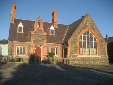
Photograph - Photograph - Colour, Dana Street Primary School From Doveton Street, Ballarat, c2007
Dana Street Primary School No 33 is one of Ballarat's earliest schools. A number of colour photographs of Dana Street Primary School, Ballarat. The photographs feature the original bluestone building, chimney, and other architectural features. The photos were taken at 7am.dana street primary school, dana street state school, bluestone -
 Kew Historical Society Inc
Plan, Melbourne & Metropolitan Board of Works : Borough of Kew : Detail Plan No.1571, 1904
The Melbourne and Metropolitan Board of Works (MMBW) plans were produced from the 1890s to the 1950s. They were crucial to the design and development of Melbourne's sewerage and drainage system. The plans, at a scale of 40 feet to 1 inch (1:480), provide a detailed historical record of Melbourne streetscapes and environmental features. Each plan covers one or two street blocks (roughly six streets), showing details of buildings, including garden layouts and ownership boundaries, and features such as laneways, drains, bridges, parks, municipal boundaries and other prominent landmarks as they existed at the time each plan was produced. (Source: State Library of Victoria)This plan forms part of a large group of MMBW plans and maps that was donated to the Society by the Mr Poulter, City Engineer of the City of Kew in 1989. Within this collection, thirty-five hand-coloured plans, backed with linen, are of statewide significance as they include annotations that provide details of construction materials used in buildings in the first decade of the 20th century as well as additional information about land ownership and usage. The copies in the Public Record Office Victoria and the State Library of Victoria are monochrome versions which do not denote building materials so that the maps in this collection are invaluable and unique tools for researchers and heritage consultants. A number of the plans are not held in the collection of the State Library of Victoria so they have the additional attribute of rarity.Original survey plan, issued by the MMBW to a contractor with responsibility for constructing sewers in the area identified on the plan within the Borough of Kew. The plan was at some stage hand-coloured, possibly by the contractor, but more likely by officers working in the Engineering Department of the Borough and later Town, then City of Kew. The hand-coloured sections of buildings on the plan were used to denote masonry or brick constructions (pink), weatherboard constructions (yellow), and public buildings (grey). This plan is the other half of Plan No.1571 representing the constructions to the west of Wellington Street before and in 1903/4. This plan represents the built environment in Edgevale Road, Wellington Street, Atkins Street, Annadale Street, Mortimer Street, and Cotham Road. Whereas there are smaller allotments and more modest housing stock facing Edgevale Road, larger blocks and more substantial houses are represented facing Cotham Road.melbourne and metropolitan board of works, detail plans, mmbw 1571, cartography -
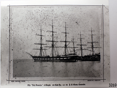 Flagstaff Hill Maritime Museum and Village
Photograph - Vessel, Sailing Ship, Fred. Kruger, Loch Vennachar of Glasgow, 1875-1888
This is a photographic image of the three-masted iron clipper Loch Vennachar created by photographer Fred Kruger of Geelong. Fred Kruger was born in Germany in 1831 and migrated to Victoria before his wife, who arrived in 1863. He began working in photography in the 1850s. He was internationally recognised for his work, which covered a variety of subjects. He settled in Geelong in later years, registering his studio in Skene St, Newtown. He passed away in February 1888. The National Gallery of Victoria now holds much of his work. Loch Vennachar: - Loch Vennachar made many journeys from Britain to Australia and was well-known in Australian ports. On one of its homeward-bound journeys from Australia, the ship sank in the River Thames. Its cargo included 850 tonnes of preserved canned rabbits from Warrnambool's Western Meat Preserving Company. The ship was raised and continued trading for another four years. On 14th June 1905, Loch Vennachar departed Glasgow for Adelaide and Melbourne. The last known sighting of it was on 6th September 1875 when overtaken by the SS Yongala; the captains exchanged the “all well” signals. After that, the ship disappeared with loss of all 27 lives, according to a list that was received by Fremantle through the English mail. The list indicated that there were no passengers on that voyage. Sadly, other Loch Line ships med with similar disasters. The list of lost crew on the Loch Vennachar included Thomas. W. Pearce, apprentice, Southampton. His father was Tom Pearce, one of the two survivors of the Loch Ard, wrecked in 1878. Also, Thomas’ grandfather, James Pearce, was the captain of SS Gothenburg at the time of her wrecking in 1875. Consequently, the wrecking of the Loch Vennachar and the Loc Sloy near the southwest point of Kangaroo Island, a lighthouse was erected, officially opening in June 1907. The northern headland of West Bay was named Vennachar Point in memory of the ship in 1908. The wreck was discovered in 1976 by divers from the Society for Underwater Historical Research, over seventy years after being lost off Kangaroo Island.The Loch Vennachar performed a significant role in Australia’s colonial trade, taking goods between Great Britain and Australia. These goods included locally preserved tinned rabbits processed at a factory in Warrnambool for overseas trade.Black and white photograph of the Loch Vennachar at the dock, without sails. (aka Loch Vennacher). Printed below photo "Loch Vennachar of Glasgow, 1485 Tons Reg. AA1 100. T.S. Ozanne, Comander" and "Fred Kruger Photo / Skene Street, Geelong" Printed below photo "Loch Vennachar of Glasgow, 1485 Tons Reg. AA1 100. T.S. Ozanne, Comander" and "Fred Kruger Photo / Skene Street, Geelong" flagstaff hill, warrnambool, shipwrecked-coast, flagstaff-hill, flagstaff-hill-maritime-museum, maritime-museum, shipwreck-coast, flagstaff-hill-maritime-village, loch vennachar, loch vennacher, loch line ship, glasgow shipping co, 1875 clipper ship, loch vennachar image., kangaroo island shipwreck, 1905 shipwreck, fred kruger photographer, photograph loch vennachar, preserved rabbits, canned rabbits, meat preserving company, western meat preserving company, 1901, 1905 -
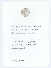 St Kilda Historical Society
Ephemera - Menu, Civic Dinner, 1984
Menu for a civic dinner hosted by the City of St Kilda (Mayor Elaine Miller) on 5 August 1983. The menu is written in French and the illustration inside is of 'Royal Street in the Old New Orleans French Quarter'. Folded white card printed in black with a gold St Kilda crest on the front and an illustration of a street in New Orleans inside.city of st kilda, civic dinners, st kilda mayor elaine miller -
 Ringwood and District Historical Society
Flyer, Land Sale Brochure, Heathmont Estate, Vic. - circa 1960
Advertisement for sale of residential lots - Heathmont Estate, opposite Heathmont Railway Station, with map and locality plan.Subdivision includes Canterbury Road, Royal Avenue, Coleman Street, Stoda Street, Herman Street, and Campbell Street. Agent - A.W. Dickson, opposite Station, Ringwood. Phone WU6007. -
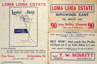 Ringwood and District Historical Society
Flyer, Land Sale Brochure, Loma Loma Estate, Ringwood East, Vic. - circa 1924
Flyer includes extract from "The Sun" 30/10/1924. "Ringwood has been created a Borough with capital value of £680,000. In 1908 there were 173 houses, 8 shops and 720 people. In 1918 the respective figures were 520, 45 and 2,080. For twelve months ended June, 1924, £51,000 worth of Home Sites were sold and £26,000 worth of new buildings were erected. Outward (train) passenger journeys have increased from 94,000 in 1919 to 182,000 in 1923. Train services have been almost doubled and time to Melbourne reduced from 60 to 37 minutes."Bi-fold double-sided land sale advertisement for Loma Loma Estate, Ringwood East, including area map, layout of the estate, and summary of local facilities and services.Subdivision includes Loma Street, Highton Street, Morinda Street, and Station Street (later Railway Avenue) Ringwood East. Agent: T.W. Burkitt, Ringwood, Phone Ringwood 157. -
 Ringwood and District Historical Society
Administrative record - Rate Books, Borough of Ringwood Valuation & Rate Cards for 1944-49 (Assessments 3193-3197), March 2012
Originally stored at Ringwood Council offices, then taken to PROV.Only source of ratepayers in the Borough of RingwoodDigital imagesFor BR Stewart (Belgrave Road), Violet Sampson (Barkly Street), Margaret Cowin (Barkly Street), Edith Phillips (Barkly Street) & Arthur George (Barkly Street, Allman's Estate). -
 Ringwood and District Historical Society
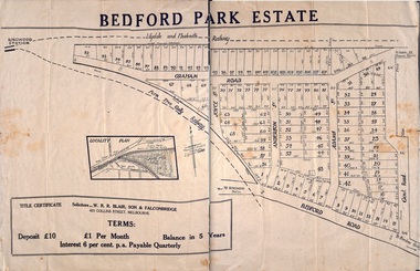
Plan - Sub-division, Bedford Park Estate, Ringwood, Victoria - 1924
Bedford Park subdivisional development did not eventuate. The land adjoining the railway line became parkland with provision for sporting facilities and the remainder was purchased by the Education Department as the site for Ringwood High School/Secondary College. Poster size land sale advertisement.Subdivision plan includes Bedford Road, Graham Road, Joyce Street, Anderson Street, and Adams Street. Solicitors - W.R.R. Blair, Son & Falconbridge, 405 Collins Street, Melbourne. -
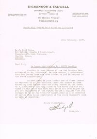 Bendigo Historical Society Inc.
Document - MCCOLL, RANKIN AND STANISTREET COLLECTION: NELL GWYNNE SYNCLINE
Manilla folder of documents relating to the Nell Gwynne Syncline Mining lease. Mentioned are Lease No.'s 10875 and 10903 which is in the Empire Road Stray Street area; R. Lethlean's Sluicing Claim; Albert Selisky has permissive Occupancy on ¼ acre; New Chum Syncline; Liddell's Chenical and Metallurgical Works; Arum Dredging Development NL. Application for a Hydraulic Sluicing Lease; Transfer of lease No. 10903, from H.J. Leed to North Nell Gwynne Gold Mines NL; Application form for the Nell Gwynne Syncline Co.. Application for leases 10945 and 10946; Nell Gwynne Syncline option to purchase lease 10945 for £1,000; Consent from Minna Matilda Lawson for inclusion of part of allotment 268 in lease No. 10875.Dickson & Tadgell Charted Accountants, 95 Queen Street, Melbourne C1gold, mining, land application, nell gwymme syncline, gold mines, bendigo -
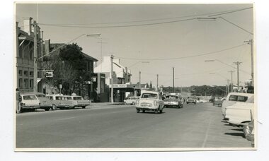 Orbost & District Historical Society
black and white photographs, 1960s - 1970s
3289.1 has been taken in the main street of Orbost - Nicholson Street. 3289.2 has been taken on the outskirts of Orbost and indicates that the town population at the time was 2800.These photographs are pictorial record of Orbost C1960s - 1970s.3289.1 is a black / white photograph of a main street with cars parked on both sides of the road and buildings on the left hand side. 3289.2 is a black / white photograph of town entry sign - "ORBOST POP. 2800".orbost-nicholson-street main-street-orbost entry-sign-orbost orbost-1960s-1970s -
 Kew Historical Society Inc
Plan - Subdivision Plan, Thornton Estate, 1918
The ‘Thornton Estate’ was the final subdivision of ‘Thornton’ in Studley Park Road. Thomas Cubitt Balmain originally owned Thornton, next to John Carson’s ‘Clutha’. Before its final subdivision, the Thomson family owned it. The Estate was a subdivision of 15 residential allotments running between Studley Park Road and Stevenson Street. The allotments faced these streets as well as Thornton Street, which the vendor undertook to make. Contemporary newspaper advertisements advised that ‘The estate possesses many advantages, notably its private and secluded, though convenient, position, splendid frontages and depths, and being close to the electric tram and Kew train, also within easy walking distance of the Victoria-street cable tram’. The terms offered purchasers were ten per cent deposit, with the balance to be paid in ten equal half-yearly payments at a rate of 5 per cent.The ‘Thornton Estate’ was the final subdivision of ‘Thornton’ in Studley Park Road. Thomas Cubitt Balmain originally owned Thornton, next to John Carson’s ‘Clutha’. Before its final subdivision, the Thomson family owned it. The Estate was a subdivision of 15 residential allotments running between Studley Park Road and Stevenson Street. The allotments faced these streets as well as Thornton Street, which the vendor undertook to make. Contemporary newspaper advertisements advised that ‘The estate possesses many advantages, notably its private and secluded, though convenient, position, splendid frontages and depths, and being close to the electric tram and Kew train, also within easy walking distance of the Victoria-street cable tram’. The terms offered purchasers were ten per cent deposit, with the balance to be paid in ten equal half-yearly payments at a rate of 5 per cent.subdivision plans - kew, thornton estate, studley park road -- kew (vic.), thornton avenue -- kew (vic.), stevenson street -- kew (vic.) -
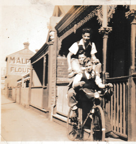 Port Melbourne Historical & Preservation Society
Photograph - Boys on bike Graham Street, Port Melbourne, c.1950
Ahe boy at the top of three on the bike pyramid is Jim SINCLAIR. Under him is Li CLEARIHAN, and seated on the bike itself, Ted McMILLAN (?). The photo taken in front of a brick cottage in Graham Street, Port Melbourne. Part of a sign for McAlpine flour can be seen on a building in the background.Sepia photograph of' three boys apparently on one bike in front of a cottage in Graham Street,Port Melbourne.On reverse: Jim Sinclair, Li Clearihan, Ted McMillan Graham St Port Melbgraham street, jim sinclair, ted mcmillan, mcalpine flour, li clearihan -
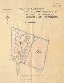 Ringwood and District Historical Society
Map - Plan of Subdivision, Part of Crown Allotment 39, Parish of Ringwood, County of Mornington - 1968
Map showing residential allotments numbered 1 to 14 Headline Court, Heathmont, Victoria, off Bronaldi Street and Yallamba Place. Adjoining lot 15 marked as 2 acres 3 roods 29.8 perches with house and garage.Paul Millar & Associates, Land & Engineering Surveyors, First Floor, 14A Main Street Croydon (Phone) 723 4493. Ref. 232B Date 23.1.68 Amended 12.3.68 & 1.12.71. -
 Port Melbourne Historical & Preservation Society
Photograph - Various streets in Port Melbourne, Ron Laing, 1990 - 1999
Part of Ron LAING's collection of photographs recording Port Melbourne over a thirteen year period. Donated to the PMH&PS by the photographer.A set of 49 colour photographs of varous streets in Port Melbourne, including Graham Street, Swallow Street (before and after wrecking), Bain Street, Graham overpass, Williamstown Road, Normanby Road, Ross Street and Bay Street, Princes Street March 1999 (Number 48 missing August 2015)built environment, ron laing -
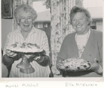 Lakes Entrance Historical Society
Photograph, Lakes Post Newspaper, International Food Banquet held in the CWA Hall Lakes Entrance Victoria, 1/07/1995 12:00:00 AM
CWA members Muriel Mitchell and Ella McKenzie at International Food Banquet held in the CWA Hall Carpenter Street Lakes Entrance Victoria 1995. These ladies were the best of friends .Black and white photograph of CWA members at International Food Banquet held in the CWA Hall Carpenter Street Lakes Entrance Victoriaclubs, social history -
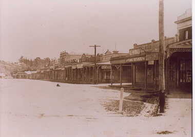
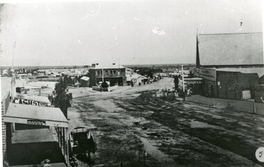 Stawell Historical Society Inc
Photograph, Lower Main Street Stawell looking West towards the Unicorn Hotel later Coffee Palace
Lower Main Street looking West towards the Unicorn Hotel later the Coffee Palace. c1882 formerly the Castlemaine Hotel and before then the Royal Hotel. Bullock wagons and horse drawn buggies in street. Railway Goods Shed and Railway Station and Church of Christ visible in distance. Anglican Church roof on right, J & A Price Grocer and Spirit Merchants.B/W. Main Street opposite where the Town Hall is now. Stawell Coffee Palace is in the centre and the Anglican Church on the right. The date is about 1880.?stawell business streetscape -
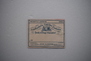 Warrnambool and District Historical Society Inc.
Label, Late 19th century, D.W.Gleeson Chemist
This label comes from the pharmacy of D.W.Gleeson. He had a chemist shop in Timor Street, Warrnambool in the late 19th century. This label is of interest as a memento of a late 19th century chemist in Warrnambool – D.W. GleesonThis is a piece of cream-coloured paper with blue edging, an Australian logo and blue printing. The paper has been pasted on to a piece of pink card. This bottle contains…. doses Gold Medallist by Competitive Examination Purity of Drugs Guaranteed Dispensing Chemist D.W.Gleeson Timor Street Warrnambool d.w.gleeson, chemist, history of warrnambool -
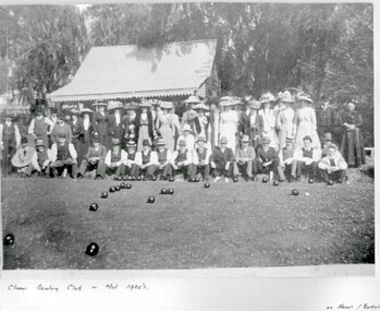 Clunes Museum
Photograph, PURCELL, ROGER, CIRCA 1900
ORIGINAL PHOTOGRAPH PROPERTY OF MR. WILLIAM HARRIS OF SUTHERLAND STREET CLUNES.BLACK & WHITE COPY OF ORIGINAL PHOTOGRAPH - GROUP OF MEN AND WOMEN ASSEMBLED AT EDGE OF BOWLING GREEN AT CLUNES BOWLING CLUB WITH BUILDING BEHIND. ORIGINAL PHOTO MADE BY HORNBY PHOTOGRAPHERS OF CLUNES.ON ORIGINAL "CLUNES BOWLING CLUB MID 1920? "HORNBY CLUNES" ON BACK "H. BARKELL CLUNES" "V. B. OWENS FRASER STREET CLUNES"local history, photography, photographs, sport, bowling club clunes -
Clunes Museum
Photograph - PHOTOGRAPHS
.1 The netball court in the photo was where "Collins Place", Fraser Street, Clunes is now located .3 the warehouse/Clunes Museum building at 36 Fraser Street, Clunes, was a former freezing worksPhotocopies of photographs .1 2 copies of girls playing netball .2 A streetscape of Fraser Street, Clunes .3 Del Mayberry (nee Campbell) and friend. The building that is now the warehouse/Clunes Museum is in the background of this photo, the building was a former freezing works .4 Jean Harling (nee Campbell) and male friend, outside The Club Hotel, Fraser Street, Clunes .5 Landscape of Clunes looking towards Station Flat Road. Port Phillip Mine is in the backgroundcampbell, netball, mayberry, harling -
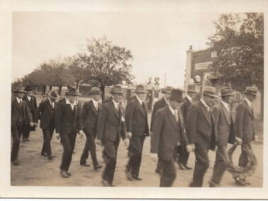 Sunbury Family History and Heritage Society Inc.
Photograph, Anzac March, C1930s
The group of men in the photograph were marching in file along Brook Street and were making their way to the War Memorial in Stawell Street. They were approaching the intersection of Brook, O'Shanassy and Stawell Streets, known locally as the 5 ways. A non-digital sepia photograph with a cream border of men dressed in suits and hats marching in file along a tree-lined street. One man holds a wreath to place on a memorial. A service station with petrol pump are to the RHS of the photograph.The words 'Kodak Print' and S579 are stamped on the back of the photograph.war memorials, anzac day, brook street, stawell street, o'shanassy street, marches -
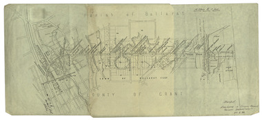 Federation University Historical Collection
Plan, Ballarat Railway Plan, 1888, 27/02/1888
.1) Copy of a Ballarat Railway Plan, running along Belford Street, from the Engineer in Chief's Office, Railway Department. It shows bridges, diversions, culverts and the following streets: Joseph Street, Lal Lal Street, Clayton Street, Belford Street, Rodier Street, trench Street, Stawell Street, Rodier Street, Belford Street, George Street, Eureka Street, Queen Street, Otway Street, Scott Parade, Ross Street, Chamberlain Street, Victoria Street, Water Street. Allotments owned by Tulloch and McLaren, J. Wilson, J. McCarthy, Mrs P. Glynn, E. Ratcliffe, soap works, Orphan Asylum .2) Copy of a plan relating to the construction of the Ballarat Railway Line. It includes shafts for the following companies: South Extended Co, Black Hill; Parade Co.; Black Hill Co.; Spanhake Co. Shaft; Black Hill South Co.; Wellingtonia Gigantiea Co., and the old workings of the Welllingtonia Gigantea Co,ballarat railway plan, belford street, lal lal street, clayton street, rodier street, trench street, south extended co., black hill, parade co., spanhake co. shaft, black hill south co., wellingtonia gigantiea co, railway -
 Clunes Museum
Photograph
FRASER STREET, CLUNES.1 BLACK AND WHITE PHOTOGRAPH OF SHOPS IN FRASER STREET CLUNES-GILL & McDONALD FAMILY BUTCHERS, CLUNES TEA ROOMS AND NEWSAGENCY. .2 BLACK AND WHITE COPY OF PHOTOGRAPH PRINTED ON GLOSS PHOTOGRAPHIC PAPERlocal history, photography, photographs, shops, gill & mcdonald family butchers, clunes tea rooms, newsagent., clunes township -
 Warrnambool and District Historical Society Inc.
Box, Swintons, Box – early 20th century
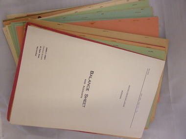
This box contains a label from the Warrnambool business of W. Swinton & Sons and this tells us that the box dates from the early 20th century (pre 1912). The documents in the box are Swinton financial balance sheets from 1928 to 1970 (W. Swinton & Sons/Swintons Pty Ltd). William and Ann Swinton migrated to Australia in 1854 and for a decade William Swinton worked as a builder and carpenter in the Warrnambool area, erecting many buildings, including the Wangoom Presbyterian Church. In 1865 he opened a store in Timor Street Warrnambool, selling groceries, glassware, china and hardware. By 1888 the business was known as William Swinton and Sons. Branch stores were opened in Cudgee, Nullawarre, Wangoom, West Warrnambool and South Warrnambool. After William Swinton died his son Robert became the first managing director of Swintons Pty Ltd. In 1934 the business split, with George Swinton and Sons selling clothing, furnishings and glassware and Swintons Pty Ltd selling seeds, produce and hardware. Today the Swinton family still operates a furniture and bedding store in Timor Street. Both these items come from the Warrnambool business of W. Swinton & Son/Swintons Pty Ltd and both the box with its early 20th century label and the financial statements are of importance. The balance sheets will be useful to researchers. The current Swinton business in Timor Street is the oldest family business in Warrnambool and, with the name Swinton associated with Timor Street businesses for 152 years, it is amongst the oldest family businesses in Australia. .1 This is a black cardboard box with a lid, with one side of the lid party detached. Some parts of the box are torn, especially the corners of the lid. The inside of the box is somewhat stained. The inside of the lid has a label pasted on and the top of the lid has a W. Swinton & Sons label pasted on. The Swintons label is partly torn away. .2 The paper material inside the box is mostly foolscap-size and consists of business financial balance statements. Some of these have coloured paper covers. ‘W Swinton & Sons Universal Produce Buyers and Exporters Timor Street Warrnambool’ swinton family, warrnambool, history of warrnambool -
 Ithacan Historical Society
Photograph, The Varigos brothers, c1920s
The four Varigos boys, from L-R: Menelaus (Dennis), Andrew, Nikolaos and Con were photographed in the 1920s outside 38 Bourke Street, Melbourne where they lived, above the family business. Their parents, Ioannis and Ioanna-Giannoula (Lekatsas) Varigos (Varvarigos) arrived in Melbourne from Ithaca in 1914 with three children - Nikolalos (Nick), Aikaterini (Rini) and Dimitrios (Jim). A further four children were born in Melbourne - Andrew, Con, Menelaus and Olga.Like many Ithacan men, Ioannis, emigrated for work and to support his family back home. Around 1900 he travelled to Umtali, Rhodesia and worked for six years before returning to Ithaca where he married Giannoula. The couple returned to Umtali where two children were born (Nikolaos and Aikaterini) and then returned to Ithaca in 1911. In 1914 they once again departed for Rhodesia but after being stranded in Port Said Ioannis decided to take the next boat which by chance was heading for Australia. The intention of was to somehow get passage to Africa from Australia, however WWI intervened and they settled in Melbourne. Ioannis and Giannoula ran the Palace Tea Rooms at 38 Bourke Street from 1920 - 1940.A black and white photograph of four young boys standing in a street in a shopping strip. -
Clunes Museum
Document - RECEIPTED INVOICE
DOCKET [INVOICE] AND RECEIPT VEGETABLE PURCHASED FROM T. STANTON CLUNES. BY A. LEVY & CO. PEEL STREET, BALLARAT.RECEIPTED INVOICE. A. LEVY & CO. WHOLESALE FRUIT AND POTATO MERCHANTS PEEL STREET, BALLARAT. T. STANTON OF CLUNES TO SUPPLY VEGETABLES MARCH 25st,1924.local history, commerce, book keeping, a levy & co