Showing 2645 items matching "lots"
-
 Eltham District Historical Society Inc
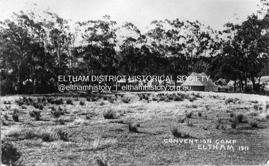
Photograph, Eltham - Convention Camp, 1911
Tents set up along the Diamond Creek on a property that would become "Willandra," a poultry farm and then in 1956, an aged care facility and residence known as Judge Book Village. It is located west of the railway line, north of the railway station in Eltham on Diamond Street. it is believed that the convention camp was for young people for the purpose of Christian fellowship, bible study and worship. Other activities included local hikes. A report in the Evelyn Observer on Friday, January 6, 1911, p2 noted: "ELTHAM. The holiday season brought out lots of visitors to our beauty spot. The visitors booked to Eltham on Boxing-Day numbered about 1900, and New Year's Day (Monday) some 1500. The threatening aspect of the weather on the morning of the 2nd and no doubt deterred many from venturing out. Fine weather has prevailed throughout, and the chief sufferers are those who catered for hot, thirsty crowds and did not find them so bent on ices and fluid refreshments as is usual at this time of the year. Campers have been strongly in evidence. One especially large camp of Christian enthusiasts being located near the station with dining booth, gospel tent, cooking range, etc., all complete, numbering some twenty tents. These good folk evidently intend to make the best of both worlds, but some of their negro camp meeting methods appear to have shocked the sensibilities of sober-going folk. With the exception of a slight ruction on the railway platform on Monday night, which will probably be aired in the local court, the holiday makers as a whole were very orderly." This photo forms part of a collection of photographs gathered by the Shire of Eltham for their centenary project book, "Pioneers and Painters: 100 years of the Shire of Eltham" by Alan Marshall (1971). The collection of over 500 images is held in partnership between Eltham District Historical Society and Yarra Plenty Regional Library (Eltham Library) and is now formally known as 'The Shire of Eltham Pioneers Photograph Collection.' It is significant in being the first community sourced collection representing the places and people of the Shire's first one hundred years.Digital imagesepp, shire of eltham pioneers photograph collection, eltham, convention camp, judge book village, tents, diamond creek (river), camping, christian camp, boxing day -
 Ringwood and District Historical Society
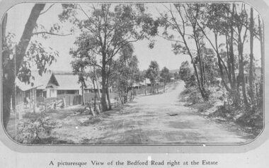
Photograph, Three images of Dublin Road Station Estate, Ringwood promotional photograph, one captioned "A picturesque View of the Bedford Road right at the Estate". 1923
Typed below one photograph, "Bedford Rd. looking towards Ringwood from Dublin Rd., 1923". Another copy is dated 1924. Typed on back of small photographs, "Dublin Rd. estate, corner Bedford Road. 77 lots no deposit and one pound per month." Printed below the small photograph, "A picturesque View of the Bedford Road right at the Estate."Printed on photograph, "Dublin Road Station Estate." Typed below enlargement, "Bedford Road looking uphill from near corner of Illoura Ave. 1923. Homes still there." Written on backing paper, "Soldiers Homes, Bedford Road". Typed on 3rd photo: "Bedford Road in Ringwood's Early Day. On reverse: "About 1924 - Area vicinity Wilana & Greenwood Ave". Reproduced on or from Dublin Road Station Estate Sales Poster 23 November 1923 (Formerly the Blood's Orchard) -
 MYLI My Community Library
Map - Nar Nar Goon County of Mornington Map, 1944, H.E Daw - Government Printer, June 1944
This was a map made in the period before Cardinia shire was created in 1994. With intricate labelling of lot allocations, this map is a invaluable research potential for understanding the settlement of the area and its development in the first half of the 1900s. A paper map with yellow shaded areas and black ink.On Left Side: Pakenham (lot numbers throughout the map) Top side: Gembrook, Tonimbuk Right Side: Bunyip, Koo-wee-rup East Bottom Side: By Authority: / H.E. Daw Government Printer / Melbourne Koo-wee-rup Bottom Right Corner: NOTE: The allotments colored brown are freehold. In respect of which the name. The Area, and the Date where given, are the particulars set out in the Crown grant as issued by the Lands Department. / After the issue of the Crown Grant, all subsequent dealings are effected at the office of titles, Queen Street, Melbourne, and particulars as to present registered ownership, boundaries, subdivisions, etc., may be obtained by search at that office. / This plan has been compiled from the Lands Department Record as at June 1944 / Nar-Nar-Goon / County of Mornington / Drawn and reproduced at the department of lands and survey, Melbourne Price 2/. June 1944 h.e. daw, map, nar-nar-goon, county of mornington, pakenham, koo-wee-rup -
 Kew Historical Society Inc
Plan, Melbourne & Metropolitan Board of Works : Borough of Kew : Detail Plan No.1591, 1905
The Melbourne and Metropolitan Board of Works (MMBW) plans were produced from the 1890s to the 1950s. They were crucial to the design and development of Melbourne's sewerage and drainage system. The plans, at a scale of 40 feet to 1 inch (1:480), provide a detailed historical record of Melbourne streetscapes and environmental features. Each plan covers one or two street blocks (roughly six streets), showing details of buildings, including garden layouts and ownership boundaries, and features such as laneways, drains, bridges, parks, municipal boundaries and other prominent landmarks as they existed at the time each plan was produced. (Source: State Library of Victoria)This plan forms part of a large group of MMBW plans and maps that was donated to the Society by the Mr Poulter, City Engineer of the City of Kew in 1989. Within this collection, thirty-five hand-coloured plans, backed with linen, are of statewide significance as they include annotations that provide details of construction materials used in buildings in the first decade of the 20th century as well as additional information about land ownership and usage. The copies in the Public Record Office Victoria and the State Library of Victoria are monochrome versions which do not denote building materials so that the maps in this collection are invaluable and unique tools for researchers and heritage consultants. A number of the plans are not held in the collection of the State Library of Victoria so they have the additional attribute of rarity.Original survey plan, issued by the MMBW to a contractor with responsibility for constructing sewers in the area identified on the plan within the Borough of Kew. The plan was at some stage hand-coloured, possibly by the contractor, but more likely by officers working in the Engineering Department of the Borough and later Town, then City of Kew. The hand-coloured sections of buildings on the plan were used to denote masonry or brick constructions (pink), weatherboard constructions (yellow), and public buildings (grey). That area of Kew bordered by Cotham Road, Park Hill Road, Ermington Lane (now Ermington Place), and Belmont Avenue contained some of the significant homes owned by Kew pioneers. Chief among these was ‘Park Hill’ on an enormous lot facing Park Hill Road. The Jubilee History of 1910 noted, six years after this plan was drawn, that: ‘Park Hill Road, forming the southern boundary of the cemetery, takes its name from Park Hill, the residence of Mr. Thomas Judd, who has resided there since December, 1852.’ Other named houses on the plan include ‘Ferndale’ facing Cotham Road; ‘Ermington’ adjacent to Judd’s Park Hill, facing Park Hill Road; and ‘Gilden’ and ‘Mont Belmont’ facing Belmont Avenue. Mont Belmont was designed by the architectural firm of Reed, Henderson and Smart for William George Lilley in 1887 and was completed in 1888. Lilley was Mayor of Kew in 1887-88, a Justice of the Peace and a member of the first Board of Guardians of Kew’s St. Hilary’s Church of England.melbourne and metropolitan board of works, detail plans, survey plans - borough of kew, mmbw 1591, cartography -
 Melbourne Tram Museum
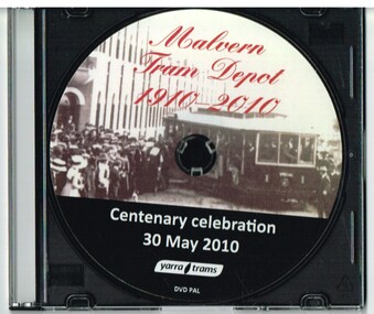
Film - Compact Diskette with video, Yarra Trams, "Malvern Tram Depot Centenary Celebration 30 May 2010", Jun. 2010
Compact Diskette with video (DVD), titled "Malvern Tram Depot Centenary Celebration 30 May 2010" - in a clear covered plastic case with a black back. Chapter 1 - "Celebrations" running time 5mins, 40secs, gives an introduction to the PMTT, Yarra trams celebrations, includes interview with Craig Tooke (COTMA), Ian Stimpson of Bendigo trams, images of 44 and 84 running in and out of the depot, speech by Michel Masson, CEO of Yarra Trams, Brian Tee, Parliamentary Secretary for Transport, historic footage of the 1910 Opening of Malvern depot. Chapter 2 - "News Footage" - running time 4mins 15 secs, ABC News excerpts, channel 9 and channel 7 news broadcasts for that night features an interview with Darren Hutchesson, Craig Tooke, Roderick Smith, Allan Pollard and Michel Masson. Chapter 3 - "Archive footage" - running time 3 mins, footage thanks to National Film and Sound Archive, titled the "Opening Prahran and Malvern Tramway " features people speaking from a spiral staircase, trams No. 1, 2 and 3 running out of the depot, 12 in Glenferrie Road, lots of people views, 6 with Mayor, 6 See also Reg Item 2450 for a Yarra Trams labelled copy of the first chapter. See also Reg Item 2451 for a copy of chapter 2. See also Reg Item 2452 for the original version ex the Archive along with the paperwork re use.trams, tramways, pmtt, opening, yarra trams, malvern depot -
 Melbourne Tram Museum
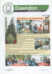
Magazine, Yarra Trams, "Malvern Depot Newsletter", "Essendon Depot Newsletter", 2006
Set of eight magazines printed in the style of a set issue in June 2006 (see Reg Item 1157). .1 - Malvern Depot - 8 pages - with a group photo in front of the depot on the front cover - article on 30 years service of Steve Olsen, Depot Marketing Staff, Tram attendants, new from Brunswick, Public Transport Cricket association, OHS and other notes. .2 - Essendon Depot - Christmas at the depot, Commonwealth Games, Think Tram, and the dog who took a tram ride. .3 - Brunswick depot - Sept. 2005 - departure of Hubert Guyot (CEO), depot works, table tennis, OH& S .4 - East Preston Depot - Sept. 2005 - departure of Hubert Guyot (CEO), message from Manager and Depot Administrator, environmental aspects, table tennis, has photos of lots of staff but no surnames. .5 - Essendon Depot - September 2005 - departure of Hubert Guyot (CEO) - various items and thanks from Lennie Bates. .6 - Malvern Depot - September 2005 - departure of Hubert Guyot (CEO) - some items from above newsletters. .7 - Malvern Depot - March 2006 - Melbourne Uni terminus works started, East Preston going green, Hugh Waldron leaves Malvern for South bank, and tennis report. .8 - Malvern Depot - September 2006 - 100 years of electric trams, late night services, tram photo competition and interview with Hugues Deleu, Ticketing Systems Manager.trams, tramways, yarra trams, malvern depot, essendon depot, brunswick depot, dogs, sports, cricket -
 Southern Sherbrooke Historical Society Inc.
Information folder - Glen Park
Folder containing information pertaining to the history of Glen Park homestead, Menzies Creek. Contents: -two pages photocopied from "That Little Train" by Peter Cuffley, showing four photos of Glen Park homestead and a short history of Edwin Johns at Glen Park (2 copies of each) -articles, "No. 861's full steam ahead again", photo shows Col Rees with Coonara Community School students, and "Living the dream" re. engine no. 861. On verso, "A Family Reunited", article by Emerald Tourist Railway re. locomotives, and "Colin just loves steam locomotion" re. engine no. 861. -4 letters, from Puffing Billy Railway, in support of Col Rees. -Letter, dated 19 June 1996, from Emerald Tourist Railway, re. appeal for restoration of Garratt engine. On verso, copy of certificate awarded to Col Rees for donation to appeal. -Letter, 1 June 1998, re. Garrett appeal. On verso, certificate awarded to Col & Kellie Rees for donation to appeal. -Aerial photo showing proposed property boundaries of Glen Park subdivision. -Aerial photo showing existing property boundaries of Glen Park. NB. last four items provided to society by Col Rees in support of subdivision. -Memorandum dated 2 May 2000 from Graham Whitt, Shire of Yarra Ranges, to Shire Service Centres, re proposed division of Glen Park land. -Fax, dated 13 June 2000, from Southern Sherbrooke Historical Society to Shire of Yarra Ranges, re. intention to make submission. -Letter, dated 14 June 2000, acknowledging receipt of above fax. -Submission, dated 18 June 2000, from Southern Sherbrooke HS, expressing concern re. proposed subdivision of Glen Park. -Fax, dated 27 June 2000, from Dianne Kueffer to Susan Heywood-Downard, Agenda Item 2 of the Yarra Ranges Planning Committee Agenda 14 March 2000, including detailed description of proposed subdivision and map. -Letter, dated 7 July 2000, Shire to Society, re. discussion of Glen Park subdivision by council. -Letter, dated 7 July 2000, Society to Shire, re. withdrawal of objection subject to certain conditions. -Letter, dated 14 July 2000, Shire to Society, re. council resolution to allow subdivision of Glen Park. -Letter, dated 24 October 2000, Shire to Society, stating that amendment to Planning Scheme allowing subdivision was approved by council and gazetted on 19 October 2000. -seven A3 sheets, showing house and property plans for new constructions proposed for Lot 1 of Glen Park subdivision. -diagram, hand-drawn (by Col Rees?) on lined A4 sheet, showing proposed development. -A1 sheet, Plan of feature survey of Lot 2 Blackhill Rd, Selby, dated 12 April 2000, showing contours, vegetation, proposed location of buildings, etc. -Glen Park Homestead and Cyprus Avenue, document prepared for the Shire Of Yarra Ranges by Helen Lardner Conservation & Design P/L, June 2003edwin johns, breen family, col & kellie rees, puffing billy -
 Flagstaff Hill Maritime Museum and Village
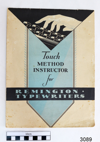
Book, Touch Method Instructor for Remington Typewriters, c. 1931
The instruction book was donated together with a typewriter and manual by David Sack, previous owner of Sack's Jewellers, Liebig St in Warrnambool. The typewriter and books were owned by William Sack, owner of the business Sacks Jewellers at 115 Liebig Street, Warrnambool. He commenced trading in the early 1900’s; and used this typewriter in the business from its purchase date, around 1931, through until about 1996. William and his wife June had three children, Eric, Audrey and David. The children were owners/partners of Sack’s Jewellers after William’s passing in 1976. Eric and David were ‘owners of the business’, with Audrey carrying out much of the clerical work. Eric died in about 1984 and David sold the practise in 1996. During the 65 years of business the typewriter was used for all the normal applications of a jeweller’s; preparing invoices, guarantees, taxation records. But in addition the four members of the Sack family were very involved in Church activities, particularly in lay administration and lay preaching in the Baptist Church, and the typewriter gained a lot of after-hours use. The family actively supported overseas Missions in India, SE Asia, and Africa. After the sale of the business in 1996, Audrey took the typewriter home for her community activities (David got a computer). In the 1980’s David volunteered as the Clock Repairer at Flagstaff Hill for the historical instruments. In the early days this took some long hours to get the clocks working, but in recent years he has just been ‘on call’ if needed. He is an alert 85 year old and just in the last 12 months has given up a busy schedule of Sunday Lay Preaching around the district. (2015) The typewriter and instruction books are of local significance, being previously owned and used in a local business for about 100 years.Book, Touch Method Instructor for Remington Typewriters. Published by Remington Typewriter Company, printed in U.S.A. Copyright 1931. Soft cover, cream with black and blue panels, drawing of a hand with fingers above typewriter keys. Lesson book for teaching touch typing.flagstaff hill, warrnambool, shipwrecked coast, flagstaff hill maritime museum, maritime museum, shipwreck coast, flagstaff hill maritime village, great ocean road, typing instructor, typing lesson book, sack’s jewellers warrnambool, remington typewriter company, william sack, david sack, warrnambool baptist church, warrnambool history -
 Eltham District Historical Society Inc
Photograph, Fay Bridge, Footbridge, Fort Knox Self Storage, 197 Sherbourne Road, Eltham, n.d
The footbridge which extended from the facility to the landscaped garden and water features is now gone. The footbridge and garden were previously part of a former hat factory in Sherbourne Road Eltham which has in the past been used for various purposes and presently a self storage business. The Karingal Yallock Creek passes through the front of the land and the creek environs are the subject of significant and unusual landscaping works, including some cascading water channels. Some of the landscaping was damaged by the Christmas Day floods of 2011, but the main elements remain intact. The landscaped area (as distinct from the factory itself) is the subject of a Heritage Overlay under the Nillumbik Planning Scheme. The basis of this overlay is a Heritage Report by Graeme Butler and Associates in 2006. As well as an assessment of the landscaped area, it includes one background information on the history of the site (although a complete history would require more research). The site was part of Crown Portion 3 of the Parish of Nillumbik that remained as the Montmorency Farm until early in the twentieth century. The 1911 subdivision of this farm created Lot 7 of some seven acres, which is the site of this factory. The Heritage Report lists the various owners of the site. From the rate records and aerial photos it is concluded that the site was used as an orchard and farmland until the 1940s. William F Crellin, orchardist, owned the site from 1912 to 1923. Then Edmund Williams owned it until 1951. In 1955 the site was owned by Rupert V. Kirsch and this is the name anecdotally associated with the hat factory, where the well-known brand of Fayrefield Hats were manufactured. There is some belief that this was built about the time of the Second World War and that hats for the armed forces were made there.fay bridge collection, eltham, fayrefield hat factory, foot bridge, sherbourne road, footbridge, fort knox eltham -
 Eltham District Historical Society Inc
Photograph - Colour Print, Belle Vue, Livingstone Road, Eltham, c.2015
Belle Vue property in Livingstone Road, Eltham was once owned by Society member Jo McCormick. Jo was a valued member of our committee and dear friend of many of our members until her death in 2009. Belle Vue is the farmhouse of a property that is now a significant part of suburban Eltham, just a short distance north of the town centre. Originally purchased by pioneer Eltham farmer Henry Stooke, the present-day old farmhouse sits within an extensive suburban residential area. The history of the property is largely based on a heritage assessment prepared by consultant Lorraine Huddle for Nillumbik Shire Council. Additional information from our Society records reveals Belle Vue farm comprised about 56 ha (140 acres) extending northerly from the northern boundary of Holloway’s 1851 Little Eltham subdivision. On the present day map the southern boundary was just north of Elsa Court and Grove Street. The western boundary was the Diamond Creek and extended northerly to Main Road where it turns easterly towards Research. It was traversed by the main road to Kangaroo Ground and beyond and from 1912 by the railway to Hurstbridge. From 1895 the farm was owned by William Williams and his wife Mary Ann. In 1914 -15 they built a new house now known as Belle Vue. They sold the land in 1920 and residential subdivision began soon after that. Belle Vue remains today on a substantially subdivided and very much reduced size residential lot in Livingstone Road. The house and many old trees on the site were subject to a heritage overlay under the Nillumbik Planning Scheme. Despite that overlay, the development and subdivision of the original land resulted in most of the heritage listed trees being removed. belle vue, eltham, livingstone road -
 Eltham District Historical Society Inc
Negative - Photograph, Rose Stereograph Company, The Bridge, Hurstbridge, Vic, c.1925
Copied from brochure "Wattle Valley Estate". The new bridge designed by Sir John Monash over the Diamond Creek near Hurst's original home "Mia Mia" seen in the distance. Reprinted from brochure advertising "Wattle Valley Estate" 7 minutes from bridge. The Wattle Valley Estate was first advertised in August 1925 as weekend building allotments by the Greater Melbourne Land and Development Company. Advertised from £28.10.0 or £60 per block. In August 1926, 30 picked allotments of 60x150 feet were put up for auction Saturday August 14, 1926 with frontages to Valley View Road and Fawkner Crescent advertised in the “Heart of the Glorious Wattle Country” and “Within 15 Minutes of the Newly Electrified Railway Station”. The Advertiser on August 13, 1926 in an article promoting the auction stated “the estate is regarded as one of the best in the district, and will be sold practically without reserve.” It is noted that an advertisement running in The Argus February 22, 1951 offered the remaining 16 blocks for sale at £12.10.0 or £200 the lot. By March 7, the remaining blocks were advertised at £17.10.0 The Wattle Valley Estate took over 20 years to sell and then people could not build on them This image was also used in a brochure advertising the "Wattle Valley Estate", which forms part of the Shire of Eltham Pioneers Photograph Collection (Cross Reference Photo No.(s): 1056, 1057). Also cross reference SEPP_1028 / 29 for other views of Mia Mia. Part of a slide show presentation "Bridges & Waterways of the Shire" by Russell Yeoman to the 13 September 1989 Society meeting. The presentation included slides of historic photos from the Shire of Eltham Pioneers collections as well as several recent views. This photo forms part of a collection of photographs gathered by the Shire of Eltham for their centenary project book,"Pioneers and Painters: 100 years of the Shire of Eltham" by Alan Marshall (1971). The collection of over 500 images is held in partnership between Eltham District Historical Society and Yarra Plenty Regional Library (Eltham Library) and is now formally known as the 'The Shire of Eltham Pioneers Photograph Collection.' It is significant in being the first community sourced collection representing the places and people of the Shire's first one hundred years.Digital image 4 x 5 inch B&W Negshire of eltham pioneers photograph collection, hurstbridge, mia mia, bridge, diamond creek (creek), monash bridge, wattle valley estate -
 Glen Eira Historical Society
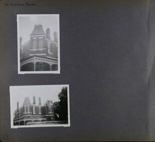
Album - Album page, Gladstone Parade, 34, Circa 1972
This photograph is part of the Caulfield Historical Album 1972. This album was created in approximately 1972 as part of a project by the Caulfield Historical Society to assist in identifying buildings worthy of preservation. The album is related to a Survey the Caulfield Historical Society developed in collaboration with the National Trust of Australia (Victoria) and Caulfield City Council to identify historic buildings within the City of Caulfield that warranted the protection of a National Trust Classification. Principal photographer thought to be Trevor Hart, member of Caulfield Historical Society. Most photographs were taken between 1966-1972 with a small number of photographs being older and from unknown sources. All photographs are black and white except where stated, with 386 photographs over 198 pages. From Caulfield Heritage Management Plan 1996 by Andrew Ward In 1889, Thomas B Jackson, an architect in Shoobra Road, owned lots 61-63 at the north west intersection with Clarence Street. He built the two red brick houses, each of 10 rooms, known as "Kenly" and "Nulmore" (later "Brampton") in that year. By 1894, P. Langwill had purchased the property, leasing it to Fred Henriques, an accountant. Alfred Pearson a government chemist, was occupying tenant by 1899. The property was known as ''Kenly''. In 1910, the house was vacant, however, in 1920, James Edmends was living there and continued to do so in 1930. By 1941, Edmends had moved to No. 32, and Alfred Williamson was in residence. "Kenly'' is important as an unusually imposing Elizabethan influenced villa in Caulfield, comparing with nos. 25 and 36 Gladstone Parade. Its importance is enhanced by its substantially intact state whilst its link with local architect Thomas B Jackson is of interest.Page 53 of Photograph Album with two exterior photographs (one portrait and one landscape) of a double storey brick mansion.Hand written: 34 Gladstone Parade [top left] / 53 [bottom left] trevor hart, 1880's, 1890's, gladstone parade, eversley, victorian, double storey, clarence street, architectural features, nulmore, brampton, kooyong park estate, architect, shoobra road, elsternwick, kenly, elizabethan influence, thomas b jackson, p langwill, fred henriques, alfred pearson, james edmends, alfred wiliamson, house names -
 City of Moorabbin Historical Society (Operating the Box Cottage Museum)
Photographs,x3 Colour Early Weatherboard Cottage Cheltenham c1880, 1981
Henry Dendy , a farmer from Sussex England, purchased 5,120 acres of land in the area of a 'Special Survey 1841' that extended from Brighton bayside North Road, East Boundary Rd to South Road. This area became known as Dendy's Brighton and as part of the sale 139 emigrant workers arrived in 1842 however Dendy was unable to find work and lodgings for these people. J.B.Were, financier took over the management of the 'Special Survey 1841' area and began to sell and lease allotments. 1850 the Squatter King brothers sold land south of Dendy's 'Special Survey 1841' to Josiah Holloway who sectioned it into 2 acre lots @ £10 each for market gardens - 'Two Acre Village' and Charles Whorral opened a small hotel - 'The Cheltenham Inn' on the main Road - Arthur's Seat Rd, later Point Nepean Rd, now Nepean Highway. Notable settlers who moved into the area were Keys, Charman, Bruton, Le Page, Fairlam, Meeres and 1862 saw the separation from Brighton and the formation of the Mooorabbin Roads Board District. .By 1879 1000settlers were living in 'Cheltenham' serviced by a Post Office with Bank, Mechanics Institute, State School No 84,Keys Hotel, Meeres Store, Sir Thomas Bent ensured the new Railway Line from Caulfield to Mordialloc went through his constituency of Cheltenham 1881 and this changed the development to the bayside area of Cheltenham away from the 'Two Acre Village ' side causing some dissention, However Cheltenham as whole prospered and this house in Pine St is typical of the cottages built c 1890- 1900 in the area. This weatherboard house c 1890-1900 in Pine St Cheltenham is typical of those built for early settler families. Photo taken 1981 by CMHS member 3 x Colour photographs of an early c 1900 weatherboard house in Pine St Cheltenham taken by CMHS member 1981Kodak Aug. 81 / Handwritten Pine St Cheltenhamkeys robert, holloway josiah, king brothers, smith j l; smith mary ann, stanley helen, chaff cutter, horse drawn carts, toll gates brighton, motor cars 1900, steam engines, early settlers, bentleigh, parish of moorabbin, city of moorabbin, county of bourke, moorabbin roads board, shire of moorabbin, henry dendy's special survey 1841, were j.b.; bent thomas, o'shannassy john, king richard, charman stephen, highett william, ormond francis, maynard dennis, market gardeners, vineyards, orchards -
 Flagstaff Hill Maritime Museum and Village
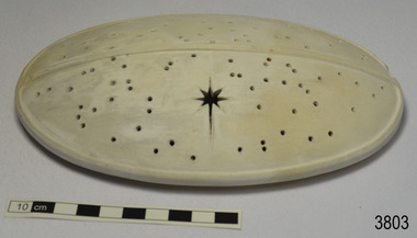
Ceramic - Cover, circa 1883
This ceramic cover was recovered from the wreck of the 1882-1883 George Roper between the late 1960’s to early 1970’s. It is one of the shipwreck artefacts in the John Chance Collection. The purpose of the cover is unclear. The holes could be for ventilation. The cover may have been used to protect food or keep it at an even temperature. It may also have been used for covering fragrant petals, allowing some scent to escape through the holes. The residue around the underside of the holes and their random placement indicate that the cover could be partially handmade. The discolouration could have come from its time in the sea. The GEORGE ROPER 1882 - 1883 - The George Roper was a 4-masted iron sailing ship built in Liverpool, England, in 1882 for fast international trade with Australia. The large vessel was launched in February 1883. The ship was on its first trip, departing Liverpool for Melbourne, captained by John Ward and a crew of 31. She had almost reached her destination on July 4 1883, approaching Port Phillip Bay and being towed by the steam tug William. The weather changed to rough with fog and both the George Roper and the William hit the dangerous Lonsdale Reef at Port Phillip Heads. The Captain and crew were eventually rescued and taken to Queenscliff. Salvage syndicates were able to recover a lot of the cargo before the George Roper broke up and sank. Amongst the cargo was soft goods, draperies, household items, spirits of malt and distilled liquors, chemicals, dynamite, and 1,400 tons of steel rails for the Victorian Government. Also in the hold were Russell Stourbridge bricks, as paying ballast. The ventilated cover is as an example of domestic ceramic ware of the 1880s. The cover also holds significance as it was recovered by John Chance, a diver from the wreck of the George Groper in the 1960s-70s. Items that come from several wrecks along Victoria's coast have since been donated to the Flagstaff Hill Maritime Village’s museum collection by his family, illustrating this item’s level of historical value. The George Roper is considered historically and archaeologically significant and as such, is listed on the Victorian Heritage Database, VHR S286. It is an example of a vessel built specifically for fast travel to and from Australia with a large shipment of cargo. The George Roper’s cargo of steel rails adds to the historical significance of international trade to the growing colony of Australia and Victoria in particular, with rail transportation soon to become a faster and safer form of transportation between colonial towns. Divers can still access parts of the scattered wreck and other artefacts recovered in the 1970s and 1980s can be viewed in both public and private collections. Cover; unglazed white ceramic, oval shape. The cover has holes randomly poked through its surface, one large hole is a six pointed star shape. Underneath there is a narrow rim placed slightly inside the edge. There is residue on the underneath around the holes. There is orange-brown discolouration and areas where the surface is lighter coloured. flagstaff hill, warrnambool, flagstaff hill maritime museum, maritime museum, shipwreck coast, flagstaff hill maritime village, great ocean road, john chance, west coast trader, george roper, w. h. potter & sons, w.t. dickson and son, captain john ward, russell stourbridge bricks, port phillip heads, lonsdale reef, dive wreck, vhr s286, coastal trader, ceramic, vintage, ventilated cover, domestic item -
 Ballarat Heritage Services
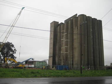
Photograph - Photograph - Colour, Lisa Gervasoni, Joe White Maltings Silos Under Demolition, 2010, 15/10/2010
"A plan to turn the Gregory Street silos into apartments is no more.Developers Eleveno Pty Ltd have abandoned plans to transform the Lake Wendouree silos into a giant apartment complex, despite previously being given the green light from the Victorian Civil and Administrative Tribunal.Director Richard Sykes yesterday confirmed the silos would be demolished."The plans are not proceeding. The plan now is to create residential houses," he said.The planning permit for an 18-lot subdivision was approved by Ballarat City Council on July 22, despite objections lodged against the application.Mr Sykes said it wasn't feasible to turn the silos into 27 units and there were many factors behind the decision."They're being demolished for various reasons, there were just better solutions," he said.Bold plans to transform the former Joe White Maltings silos into apartments were first submitted to Ballarat City Council in January 2007.However, developers took the proposal to VCAT in September 2008 after council failed to make a decision in the required 60-day timeframe.A hearing was held in early 2009 and the development was approved in March last year.Mr Sykes said it was found that the building would most likely be out of place in the region."We found the market didn't really want that sort of development," he said."They're probably more suited for inner-city development, rather than regional areas."Mr Sykes did not put a price on either the proposed development or the demolition, but said it would "cost a fair amount of money".He said once the demolition permit has been passed, works were expected to begin in November." (Ballarat Courier, 03 August 2010)Joe White Maltings Silos in Gregory Street Ballarat under demolition, to make way for a housing development. The silos were built on the banks of Lake Wendouree. joe white maltings, silo, eleveno pty ltd, lake wendouree, demolition, gregory street ballarat, wendouree parade, architecture -
 Flagstaff Hill Maritime Museum and Village
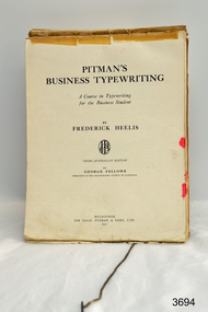
Book - Textbook, Pitman's Business Typing, 1937
This Pitman’s Business Typing textbook was owned by Audrey Sack and was donated by David Sack at the same time as a typewriter in its case plus accessories (refer to RN 3087). Audrey was the daughter of William Sack, owner of the business Sacks Jewellers at 115 Liebig Street, Warrnambool. William commenced trading in the early 1900’s; and the typewriter was used by Audrey in the business from the late 1930’s through to about 1996 when the business was sold. William and his wife June had three children, Eric, Audrey and David. The children were owners/partners of Sack’s Jewellers after William’s passing in 1976. Eric and David were ‘owners of the business’, with Audrey carrying out much of the clerical work. Eric died in about 1984 and David sold the practise in 1996. During the 65 years of business the typewriter was used for all the normal applications of a jeweller’s; preparing invoices, guarantees, taxation records. But in addition the four members of the Sack family were very involved in Church activities, particularly in lay administration and lay preaching in the Baptist Church, and the typewriter gained a lot of after-hours use. The family actively supported overseas Missions in India, SE Asia, and Africa. After the sale of the business in 1996, Audrey took the typewriter home for her community activities (David got a computer). In the 1980’s David volunteered as the Clock Repairer at Flagstaff Hill for the historical instruments. In the early days this took some long hours to get the clocks working, but in recent years he has just been ‘on call’ if needed. He is an alert 85 year old and just in the last 12 months has given up a busy schedule of Sunday Lay Preaching around the district. (2015) The textbook is associated with the typewriter, which is of local significance, being previously owned and used in a local business for about 100 years.Textbook, "Pitman's Business Typing". Brown paper covered, hard cover, published in 1937. Book has attached cord to enable it to stand during use. Book belonged to Audrey Sack.Handwriten name "Audrey Sack, … Warrnambool …WHS" (Warrnambool High School) 18/8/15"flagstaff hill, warrnambool, shipwrecked coast, flagstaff hill maritime museum, maritime museum, shipwreck coast, flagstaff hill maritime village, great ocean road, typewriter, touch typing, office communications, sack’s jewellers warrnambool, william sack, david sack, audrey sack, typing textbook -
 Marysville & District Historical Society
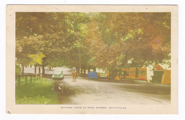
Postcard (Item) - Colour postcard, Nucolorvue Productions, Autumn Tints in Main Street, Marysville, c1940s
A colour photograph of Murchison Street in Marysville in Victoria during Autumn.A colour photograph of the main street in Marysville in Victoria during Autumn. This street is now known as Murchison Street. This postcard was produced by Nucolorvue Productions as a souvenir of Marysville.POST CARD NUCOLORVUE PRODUCTIONS, ELWOOD, VICTORIA "Roseleigh"/ 27/12/47 My Dear Shirlie,/ Just a few lines to let you know we/ are having a lovely time at Marysville./ We had a lovely Christmas/ dinner of turkey and plum pudding. We had a/ dance Christmas night st the house and it was/ very enjoyable. There are lovely kind friendly/ people here, and everything is very pleasant./ We went for a lovely walk to the/ wishing well and the Taggerty river yesterday/ morning. Yesterday afternoon we went in for/ a swim in the swimming pool and it/ was lovely. Last night we had a bit of a talent/ quest and I won the ladies section and a man/ won the mens. So I was very pleased! Well/ think I will say cheerio for the moment, with/ lots of love from Dot xxxxxx/ P.S. Please give my very kind regards to/ Ivan. murchison street, marysville, victoria, nucolorvue productions, postcard, souvenir -
 Ringwood and District Historical Society
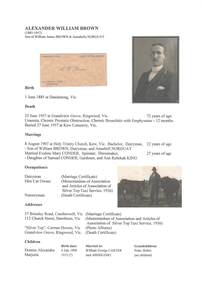
Document - Biography - Family Tree Extract, Alexander William Brown (1885-1957) - Nurseryman, Grandview Grove Ringwood (Warranwood) Vic
A4 folder containing genealogical information, copy of will and copy of probate administration record including real estate assets for A.W. Brown, Grandview Grove Ringwood (Warranwood) Vic.EXTRACT: Inventory of Real Estate Assets (for Probate purposes) 1. Grandview Grove, Ringwood Land containing 10 acres or thereabouts situate in Grandview Grove Ringwood being part of Crown Section 20 Parish of Warrandyte County of Evelyn and being the land described in Certificate of Title Volume 5781 Folio 174 on which is erected a 7 room house, a bungalow, shed and 2 glass houses valued by E. Miles, Ringwood - £5077-0-0 2. Kardinia Crescent, Ringwood Land containing 2 acres 3 roods 24-1/2 perches situate in Kardinia Crescent Ringwood being Lots 33 and 34 on Plan of Subdivision Number 12040 and being part of Crown Section 20 Parish of Warrandyte County of Evelyn and being the land described in Certificate of Title Volume 7141 Folio 080 valued by E. Miles at £350-0-0 -
 Bendigo Military Museum
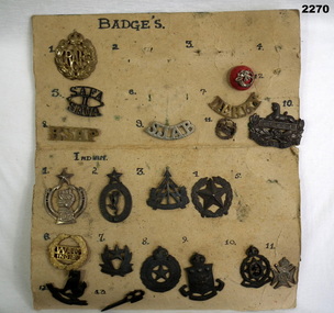
Badge - BADGE COLLECTION MOUNTED, C.WW2
Items in the collection re Ian McLeod RWAFF, refer Cat No 2262.2 for service details.Panel One only, a lot of Indian badges. .1) RAF badge .2), .3), .4) .6) missing .5) SAFA 11 SAVA .7) Derby .8) RSAP .9) SJAB .10) Gloucestershire, Eygpt with Lion .11) Eygpt, Lion, Surronded by oak leaf cluster .12) Red button badge, with a bugle and K R motif over it Panel Two .1) Circular badge .2) Indian signals corps badge. oval shape surmounted with 5 pointed star .3) Indian reconaisance corp badge symbolic tree and arrow .4) Indian engineers badge. 5 point star surrounded by oak leaf cluster .5) Missing .6) WAC India .7) Indian intelligence corps. 5 pointed star .8) Indian electrical and mechanical engineers badge .9) Indian army ordinance badge .10) Indian army medical corps .11) Symbolic cross .12) Burma intelligence corps .13) Stylised trench raid weapon Panel Three .1) Crossed khukris .2) Cross khukris .3) Simple doughnut shaped ring .4) Doughnut shaped ring. surmounted by a crown in center is letters X1 .5) JAT Regiment badge large letters IX surmounted with a crown .6) Regiment cluster of leaves .7) Madras regiment badge .8) Unknown 4 sort of legs surrounded with a crown .9) Dogras Regt. In the centre are the number 17 surmounted with a crown .10) Punjab regt. Center is a 5 pointed star with numbers 14 surmounted with a crown .11) Missingbadges, collection, indian -
 Eltham District Historical Society Inc
Photograph - Digital Photograph, Alan King, Alistair Knox Park, Eltham, 2008
Alistair Knox Park, an oasis of peace and beauty. Covered under National Trust of Australia (Victoria) Landscape Significance and Heritage Overlay, Nillumbik Planning Scheme. Published: Nillumbik Now and Then / Marguerite Marshall 2008; photographs Alan King with Marguerite Marshall.; p173 It is hard to imagine that the Alistair Knox Park, an oasis of peace and beauty beside busy Main Road, Eltham, was once the township’s rubbish dump. It was only in the 1970s that the tip was transformed into this beautiful six hectare space, which later earned it a National Trust Landscape classification. Before its life as a dump, the area was used for small farms. Thanks largely to the foresight and efforts of local environmental builder Alistair Knox, the park was designed sympathetically with the character of the wider Eltham landscape. Then, appropriately, the park was named after Knox, who was an Eltham Shire Councillor from 1971 to 1975 and Shire President in 1975. The park designers were four major forces in the urban bush landscape garden –Knox, landscape designer Gordon Ford, artist Peter Glass and landscaper Ivan Stranger. The National Trust citation for the park, originally called Eltham Town Park, includes the Eltham railway trestle bridge and the Shillinglaw Cottage. The citation states ‘the semi-natural setting of the parkland provides a landscape which is evocative of the history of the area’. Manna Gums (Eucalyptus viminalis) and Candlebarks (Eucalyptus rubida) are significant features. Most of the park’s construction was directed by Bob Grant, Superintendent of the Parks and Gardens Department for the Eltham Shire Council. First plantings occurred in Arbour Week in 1973, then the lake and botanic area were completed in 1975, with Federal Government funding, and the toilet block in 1978. Bounded by the Eltham railway line, Panther Place, Main Road, Bridge and Susan Streets, the park is in a valley about a kilometre wide overlooked by steep hills at the east and west. The Diamond Creek flows through it and the picturesque historic timber trestle railway bridge edges the north. Informal plantings of Australian indigenous and native species in open and undulating grassed settings blend with the natural landscape of the Diamond Creek to the west. The bush-style plants, particularly around the creek, balance with open lawns, paths and a cascade flowing from a small lake to another below. A footbridge over the creek leads to the park’s west. The park includes an adventure playground and barbecue areas. The park stands on part of the land bought from the Crown in 1851 by Josiah Holloway, who subdivided it into allotments and which he called Little Eltham. Most of the land was subdivided into residential lots, but the creek valley, on which the park stands, was subdivided into farm-size lots, used mainly for orchards and grazing. One of the earliest owners was John Hicks Petty, who in 1874 bought a plot from Holloway. Other families who owned properties in that area, included Rees, Clark, Waterfall, Graham, Hill and Morant. In 1901 the railway was built through the area. Jock Read, an Eltham resident since around 1920, remembers several farms in the 1920s and ’30s that occupied the site of today’s park. A poultry farm, which extended from present day Panther Place, was owned by the Gahan family. Next to that farm was another for grazing cattle owned by Jack Carrucan. Beside this was land owned by John Lyon. A doctor lived beside this, and at the north-west corner of Bridge Street and Main Road stood a memorial to the soldiers who died in World War One, which was later moved to the RSL site. Mr Read also remembers other farms and orchards west of the creek In the early 1960s the Eltham Council began buying these farms and in the late 1960s turned the areas east of the Diamond Creek into a garbage tip. When this was filled above the creek’s flood plain, the tip was moved to the west of the creek.This collection of almost 130 photos about places and people within the Shire of Nillumbik, an urban and rural municipality in Melbourne's north, contributes to an understanding of the history of the Shire. Published in 2008 immediately prior to the Black Saturday bushfires of February 7, 2009, it documents sites that were impacted, and in some cases destroyed by the fires. It includes photographs taken especially for the publication, creating a unique time capsule representing the Shire in the early 21st century. It remains the most recent comprehenesive publication devoted to the Shire's history connecting local residents to the past. nillumbik now and then (marshall-king) collection, alistair knox park, eltham -
 Eltham District Historical Society Inc
Photograph - Digital Photograph, Alan King, Sweet Bursaria, 2008
Published: Nillumbik Now and Then / Marguerite Marshall 2008; photographs Alan King with Marguerite Marshall.; p181 The rare Eltham Copper Butterfly, Paralucia pyro-discus, was saved from near extinction by a community campaign in the late 1980s. Thanks to that effort, the butterfly, a form of the Fiery Copper Butterfly, with a wing span of only 2.5cm, can be seen in parts of Eltham and Greensborough from late November to April. As late as 1987 the butterfly was thought to be near extinction. But that year, entomologist, Michael Braby, found several colonies, including two major ones in natural bushland on Diosma Road, Eltham. However these were threatened with destruction, as their habitat was to be destroyed by a development of 71 houses. The colonies were on a 14 hectare subdivision owned by Esanda Finance, an ANZ Bank subsidiary. It would cost around $5 million, to reimburse the bank for the land. The butterfly, which depends on woodland, a stunted form of the Sweet Bursaria bush, and the Notoncus ant, was considered too fragile to relocate. Braby’s discovery led to a sometimes fiery two-year campaign, which even became an election issue. It involved the local community, local and state governments and the developer, before a compromise was reached. The larvae have an intricate relationship with the small black ant, Notoncus. During the day, the larvae shelter in nests made by the ants around the base of the trunk and roots of the Sweet Bursaria (Bursaria spinosa). The ants are thought to protect the larvae from predators and parasites, as they attend them from the nests to feed on the Bursaria leaves at night. In return, the larvae excrete a sugar solution, which the ants love to eat. The butterfly was first recorded in Victoria in 1893, and first collected scientifically from Eltham in 1931. But it was only officially named in 1951, by Victoria’s then top butterfly expert, David Crosby.2 However, from 1970, rapid housing development in Eltham destroyed much of the butterfly’s habitat. The discovery of several major colonies in 1987 met with great excitement, and 250 people attended the first local public meeting. The State Government commissioned Crosby to investigate how to protect the butterfly, and the council froze development for three weeks. Then Esanda agreed to suspend development for several months, until a compromise was reached. Crosby recommended that 62 of the 71 lots be kept to ensure the butterflys’ survival. However this would cost $1 million to $1.5million in compensation to Esanda. Greensborough MP Pauline Toner, launched a $1million fundraising campaign and many artists donated their works to the appeal. Toner offered Clifton Pugh’s painting Eltham Copper Country to millionaire Alan Bond for $1 million, after having heard that he had offered $6 million for the Van Gough painting Sunflowers. However Bond did not accept. The butterfly was considered a ‘hot’ election issue during the by-election, following Pauline Toner’s resignation. Liberal party candidate, Margaret Brown, was accused of falsely saying she had been involved in the butterfly campaign so as to win votes. Sadly, the $1million appeal fell short at $426,000, so a compromise was reached. The State Government donated the Education Department site on Eucalyptus Road, but only nine lots of the Diosma site were bought, and the rest of the development went ahead. On March 3, 1989, Ms Toner died, and the Eucalyptus Road site was named in her honour. Around 2000 the butterfly was further threatened by proposed developments on Pitt Street, facing the Pauline Toner Reserve and between Diosma and Nyora Roads. Fortunately the Friends of the ECB, with the Shire of Nillumbik, ensured that more habitat was made available. The butterfly now survives in seven sites in Eltham and Greensborough, including the main sites at the Pauline Toner Reserve on Eucalyptus Road, the Western and Eastern colonies on Diosma Road, and the Yandell Reserve in Greensborough.The butterfly survives also in Castlemaine and in the Kiata and Salisbury areas. However, it remains endangered.This collection of almost 130 photos about places and people within the Shire of Nillumbik, an urban and rural municipality in Melbourne's north, contributes to an understanding of the history of the Shire. Published in 2008 immediately prior to the Black Saturday bushfires of February 7, 2009, it documents sites that were impacted, and in some cases destroyed by the fires. It includes photographs taken especially for the publication, creating a unique time capsule representing the Shire in the early 21st century. It remains the most recent comprehenesive publication devoted to the Shire's history connecting local residents to the past. nillumbik now and then (marshall-king) collection, eltham copper butterfly, sweet bursaria -
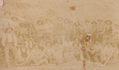 The Beechworth Burke Museum
Photograph, Walter William McLean Thwaites, c.1870
This photograph depicts a large group of men in their work clothing situated in front of a large bank of earth. They are identified as miners working in an unidentified location in Australia. This photograph was taken by photographer Walter Thwaites sometime during the period of 1865-1908, likely c.1870. It is unsure where this image was taken since Thwaites travelled a lot over his photography career and the photograph is not annotated with this information. In addition, the identities of the men in the photograph are also unknown. These men are photographed in front of a large bank of earth where they had presumably been mining for gold or other precious metals. The men, with the exception of four, are wearing wide brimmed hats to protect their faces from the sun. They are also wearing loose fitting white shirts which are often worn beneath a darker coloured vest. They wear pale coloured work pants and boots. The men are mostly clean shaven with the exception of the moustache and a couple of beards. Two of the men have pipes in their mouth. Their clothing is basic and much less dramatic than the outfits worn by the gold diggers of the 1852 gold rush. These men, by wearing similar outfits, are expressing a sense of comradery or equality between them. It is likely that they are from the same, or similar, social status. They have an air of independence and share social equality in their stance and clothing. Walter William McLean Thwaites (1840-1908) was a professional photographer born in Sydney, Australia. He learnt the craft in his father's Hobart studio, but later embarked on his own solo career and toured every existing Australian colony between 1860 to 1888. The Thwaites family were a long line of photographers and artists with Thwaites' father Walter WIlliam Thwaites Sr working as an artist and photographer in Australia after moving from England in 1834. Walter Thwaites Sr's father, also named Walter Thwaites, was a British miniature portrait artist.Images, like this one, of Australian gold rush history can reveal important information about the social and environmental impact of this period. This image depicts over 30 diggers standing in front of a bank of earth and therefore, this image has the capacity to reveal or support significant information for researchers studying the fashion and social status of diggers in Australia in approximately 1870. It can also provide information on the landscape of Australia in this period and the impact of mining for gold on both society and the Australian landscape. The Burke Museum is home to a substantial collection of Australian mining photographs which can be used to gain a deeper understanding into life on the gold fields, technology used in mining, the miners themselves and the impact of the gold digging on the environment.Sepia toned rectangular photograph printed on matte photographic paper and mounted on board.Reverse: 1997.208 / MINERS. / W. Thwaites / Photography /australia, australian photography, photography, miners, gold rush, australian landscape, diggers, walter thwaites, thwaites photography, w. thwaites photography, social history -
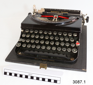 Flagstaff Hill Maritime Museum and Village
Machine - Typewriter, 1930's
This "Remington Portable Model 5, Remington Business Service" typewriter is in very good working order and was donated in its case complete with its Operating Instructions and a Touch Method typing instruction book. The typewriter was owned by William Sack, owner of the business Sacks Jewellers at 115 Liebig Street, Warrnambool. He commenced trading in the early 1900’s; and used this typewriter in the business from its purchase date, around 1931, through until about 1996. William and his wife June had three children, Eric, Audrey and David. The children were owners/partners of Sack’s Jewellers after William’s passing in 1976. Eric and David were ‘owners of the business’, with Audrey carrying out much of the clerical work. Eric died in about 1984 and David sold the practise in 1996. During the 65 years of business the typewriter was used for all the normal applications of a jeweller’s; preparing invoices, guarantees, taxation records. But in addition the four members of the Sack family were very involved in Church activities, particularly in lay administration and lay preaching in the Baptist Church, and the typewriter gained a lot of after-hours use. The family actively supported overseas Missions in India, SE Asia, and Africa. After the sale of the business in 1996, Audrey took the typewriter home for her community activities (David got a computer). In the 1980’s David volunteered as the Clock Repairer at Flagstaff Hill for the historical instruments. In the early days this took some long hours to get the clocks working, but in recent years he has just been ‘on call’ if needed. He is an alert 85 year old and just in the last 12 months has given up a busy schedule of Sunday Lay Preaching around the district. (2015)The typewriter is of local significance, being previously owned and used by Sacks Jewellers, a local business that had been in operation for about 100 years.Typewriter, Remington, "Remington Portable Model 5, Remington Business Service". Typewriter is in black, textured hard case with lock and key. Case has leather carry handle. Company has USA, copyright 1931.Includes Operating Instructions for the Remington Portable Models 5 and 5T. Remington Typewriter Company. "Remington Portable Model 5, Remington Business Service". flagstaff hill, warrnambool, shipwrecked coast, flagstaff hill maritime museum, maritime museum, shipwreck coast, flagstaff hill maritime village, great ocean road, typewriter, remington business services, office equipment, business equipment, office communication, sack’s jewellers warrnambool, warrnambool business, remington typewriter company, touch typing, william sack, david sack, warrnambool baptist church -
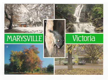 Marysville & District Historical Society
Postcard (item) - Colour postcard, Nucolorvue Productions Pty. Ltd, Marysville-Victoria, Pre 2009
A postcard with 5 colour photographs of local attractions in and around Marysville in Victoria.A postcard with 5 colour photographs of local attractions in and around Marysville in Victoria. This postcard was produced by Nucolorvue Productions as a souvenir of Marysville.MARYSVILLE/ Victoria 1. Burrengeen Park in Winter./ 2. Steavenson Falls./ 3. Autumn tonings of Marysville./ 4. Olde Yarra Track Shoppe./ 5. Mountain Grey (Brushtail) Possum. NU-COLOR-VUE/ OF/ AUSTRALIA AFFIX/ STAMP/ HERE/ 18 MA002/ NCV 5408 ADDRESS/ POSTCODE Made in Australia Date Stamp MARYSVILLE VIC AUST DEAR MELISSA,/ HERE IT IS MELISA/ YOUR OWN CARD AS/ REQUESTED. I AM/ RELAXING IN FRONT OF/ A HUGE LOG FIRE AT/ THE MOMENT BEFORE/ ATTACKING A 4 COURSE/ MEAL FOR TEA. I/ HAVE SETTLED IN TO/ THIS WAY OF LIFE/ ALREADY AND AM THROUGH/ LY ENJOYING IT. LOTS/ OF PAINTING MATERIAL/ AROUND HERE TOO. HEATED/ POOL (SALT) IS BEAUT./ SEE YOU LATER/ Jess xx M/S MELISA THOMSON/ C/- COCA-COLA BOTTLERS/ 128 BRIENS RD/ NORTHMEAD 2152/ SYDNEY/ N.S.W. COPYRIGHT/ Nucolorvue Productions Pty. Ltd. Telephone: (03) 560-1788marysville, victoria, burrengeen park, steavenson falls, autumn, yarra track, mountain grey possum, brushtail possum, nucolorvue productions, postcard, souvenir -
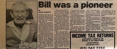 Melton City Libraries
Newspaper, Bill was a pioneer, 1989
Bill Cahill in conversation at Victoria Hall Melton South July 1974 Chaff Mills Melton’s hey day, as I call it in the days when more hay was grown in Melton and Rockbank than, I’d say in any where in Victoria. We had two chaff mills. If I can remember rightly I’m sure of this, that in one month the amount of hay and chaff that went from Melton to Melbourne was about 1800 tons, that’s hay and chaff. There was a lot of hay went from the Melton Railway Station. I have often seen whole train load going down the Schutt and Barrie, that’s Bonnie’s father’s mill at West Footscray. The mills in those days employed up to from 18- 20 men in each, that was before electricity when the mills were run on steam then, there was no power. At times those chaff mills they got a lot of shipping orders, to the Philipines and other Asian countries. They’d work shifts at night on the second shift at night time they would have an old hurricane lamp hanging above from the ceiling just over the chaff cutter, you could hardly see yourself, or see the anything. Well they worked through the whole night they might have an order come in for perhaps 100tons up 500 tons of chaff to go a boat would be in and be waiting to be loaded in Melbourne and they’d have to go and work two shifts. Then they brought in casual labour to help them through and get the order cut and get it down by rail to ship board to send it away. Talking about the hay I’ve seen wagons of hay in the farmers carting to both mills and also hay going down to West Footscray. There would be a quarter of a mile without exaggeration wagons and teams would be waiting to get into the mill, they would come down at the weighbridge at about 3-4- o’clock, 2 o’clock waiting for the bridge to open to weigh their loads, the ones that would be running late would be there at the weighbridge about half past 7 - 8 o’clock. They would be lucky to get away by night before getting their load off. A funny episode I remember well was a farmer from up, Alan Hurley you would remember him, Sam McCorkell he would put on his load in the afternoon or evening leave it up the yard, and would leave Toolern Vale about 12 or 1 o’clock in the morning and he would get down to the weighbridge and when it was breaking day he would bring half of his fowl yard down with him. The fowls would hop up on top of the load and have a ride down and when it came daylight they’d hop off and away they’d go, and I suppose everybody had some of McCorkells poultry. [laughter from the audience] That always tickled my fancy and everybody would be laughing about the fowls getting off his load of hay. I reckon that was about one of the funniest things I’ve ever heard of. The Victoria Hall, where we are tonight was originally known as the Exford Hall. I believe Bonnie’s father was the original builder and owner of the chaff mills here round the corner which is known as Wards today. Later on I understand that his father had a chaff mill here were this hall is, then Dixon Bros were just a bit on the other side. I believe Bonnie’s father sold it to Dixon Bros, and they shifted this part of the mill here and took it over and joined it up. That’s the history of the early chaff mills. Is that right Bonnie? You might like to correct, I’m about right am I? Bonnie answers yes. The original audio tape was recorded on the reel to reel tape recorder by Bon Barrie using his own tape recorder. Transferred to CD by Tom Wood using computer technology capable of adjusting the recording to a legible speed for reproduction to compact disk. Bill Cahill article featured in the The Mail Expresslocal identities -
 Eltham District Historical Society Inc
Photograph - Digital Photograph, Alan King, Pauline Toner Butterfly Reserve, 2008
One of seven sites in Eltham and Greensborough where the butterfly survives. Published: Nillumbik Now and Then / Marguerite Marshall 2008; photographs Alan King with Marguerite Marshall.; p181 The rare Eltham Copper Butterfly, Paralucia pyro-discus, was saved from near extinction by a community campaign in the late 1980s. Thanks to that effort, the butterfly, a form of the Fiery Copper Butterfly, with a wing span of only 2.5cm, can be seen in parts of Eltham and Greensborough from late November to April. As late as 1987 the butterfly was thought to be near extinction. But that year, entomologist, Michael Braby, found several colonies, including two major ones in natural bushland on Diosma Road, Eltham. However these were threatened with destruction, as their habitat was to be destroyed by a development of 71 houses. The colonies were on a 14 hectare subdivision owned by Esanda Finance, an ANZ Bank subsidiary. It would cost around $5 million, to reimburse the bank for the land. The butterfly, which depends on woodland, a stunted form of the Sweet Bursaria bush, and the Notoncus ant, was considered too fragile to relocate. Braby’s discovery led to a sometimes fiery two-year campaign, which even became an election issue. It involved the local community, local and state governments and the developer, before a compromise was reached. The larvae have an intricate relationship with the small black ant, Notoncus. During the day, the larvae shelter in nests made by the ants around the base of the trunk and roots of the Sweet Bursaria (Bursaria spinosa). The ants are thought to protect the larvae from predators and parasites, as they attend them from the nests to feed on the Bursaria leaves at night. In return, the larvae excrete a sugar solution, which the ants love to eat. The butterfly was first recorded in Victoria in 1893, and first collected scientifically from Eltham in 1931. But it was only officially named in 1951, by Victoria’s then top butterfly expert, David Crosby.2 However, from 1970, rapid housing development in Eltham destroyed much of the butterfly’s habitat. The discovery of several major colonies in 1987 met with great excitement, and 250 people attended the first local public meeting. The State Government commissioned Crosby to investigate how to protect the butterfly, and the council froze development for three weeks. Then Esanda agreed to suspend development for several months, until a compromise was reached. Crosby recommended that 62 of the 71 lots be kept to ensure the butterflys’ survival. However this would cost $1 million to $1.5million in compensation to Esanda. Greensborough MP Pauline Toner, launched a $1million fundraising campaign and many artists donated their works to the appeal. Toner offered Clifton Pugh’s painting Eltham Copper Country to millionaire Alan Bond for $1 million, after having heard that he had offered $6 million for the Van Gough painting Sunflowers. However Bond did not accept. The butterfly was considered a ‘hot’ election issue during the by-election, following Pauline Toner’s resignation. Liberal party candidate, Margaret Brown, was accused of falsely saying she had been involved in the butterfly campaign so as to win votes. Sadly, the $1million appeal fell short at $426,000, so a compromise was reached. The State Government donated the Education Department site on Eucalyptus Road, but only nine lots of the Diosma site were bought, and the rest of the development went ahead. On March 3, 1989, Ms Toner died. Thee Eucalyptus Road site was named in her honour. Around 2000 the butterfly was further threatened by proposed developments on Pitt Street, facing the Pauline Toner Reserve and between Diosma and Nyora Roads. Fortunately the Friends of the ECB, with the Shire of Nillumbik, ensured that more habitat was made available. The butterfly now survives in seven sites in Eltham and Greensborough, including the main sites at the Pauline Toner Reserve on Eucalyptus Road, the Western and Eastern colonies on Diosma Road, and the Yandell Reserve in Greensborough.5 The butterfly survives also in Castlemaine and in the Kiata and Salisbury areas. However, it remains endangered.This collection of almost 130 photos about places and people within the Shire of Nillumbik, an urban and rural municipality in Melbourne's north, contributes to an understanding of the history of the Shire. Published in 2008 immediately prior to the Black Saturday bushfires of February 7, 2009, it documents sites that were impacted, and in some cases destroyed by the fires. It includes photographs taken especially for the publication, creating a unique time capsule representing the Shire in the early 21st century. It remains the most recent comprehenesive publication devoted to the Shire's history connecting local residents to the past. nillumbik now and then (marshall-king) collection, eltham copper butterfly, pauline toner butterfly reserve -
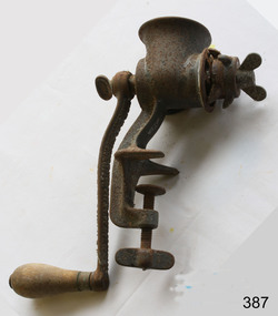 Flagstaff Hill Maritime Museum and Village
Functional object - Mincer, late 19th or early 20th Century
A meat grinder, commonly known as the meat mincer, is used for chopping meat into fine pieces. Alternatively, it can be used for the mixing of raw or cooked meat, fish and vegetables. It is the best way to process meat, and is a widely used piece of equipment by butchers and in the home.. Butchers have been known to use either mincing knives or meat cleavers in the kitchen for years to produce a quantity of minced meat. This was a slow and laborious process. The advent of the meat mincer has not only made the mincing process easier but also faster. The meat mincer has slowly evolved over the years into what it is today. The first meat mixer or meat mincer was invented in the 19th century by a German inventor named Baron Karl Drais. Although some versions of the device date back to much earlier. The oldest form of meat mincer was hand cranked which forced meat through a metal plate with several small holes in it, which resulted in long and thin strands of the meat. The meat was fed into the funnel that was placed at the top of the mixer. This meat would pass through a hand cranked screw conveyor that would squash and mix the meat before passing it through the metal plate. Needless to say, this was again a slow and laborious procedure to follow to produce large quantity of meat. With passage of time, this hand cracked machine became powered by electricity. The meat mincer has a great adaptability and efficiency now. The huge variety in mincer plates allows a butcher to produce different types of minced meat in any shape desired. However, traditional manual meat mincers have not really changed a lot. They are manually operated and made of cast iron, as earlier. They are similar to the original mincer designs, dating back to the early 1900s. Some butchers still prefer using a variety of mincer knives. Adapted from: https://brennan-group.com/blogs/news/history-of-the-meat-mincerThe development of the meat mincer enabled both butchers and home cooks to process and grind meat effectively.Clamp on meat mincer with handle for rotating the mincing apparatus inside.None.flagstaff hill, warrnambool, shipwrecked-coast, flagstaff-hill, flagstaff-hill-maritime-museum, maritime-museum, shipwreck-coast, flagstaff-hill-maritime-village, meat mincer -
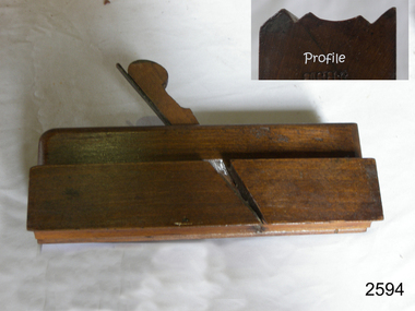 Flagstaff Hill Maritime Museum and Village
Tool - Wood moulding Plane, Christopher Gabriel, 18th Century
The story of Christopher Gabriel born on April 2, 1746, in Falmouth England is a tale of a poor boy who made good. Shortly before he turned thirteen years of age in 1759 he was apprenticed to a local master carpenter, recorded as a Mr Barnicot the master trained his apprentice well as we can assume by Christopher's later successes. The apprenticeship ended in 1766 after seven years when Christopher reached twenty. Then in 1768, he relocated to London walking the two hundred miles from Falmouth carrying his possessions in a sack. He no sooner arrived in London when he met Alice Trowell who became his wife in March 1769. They set up house on Albermarie Street Clerkenwell and by the first of 1770, Gabriel had begun his business of plane making. It has been speculated that Gabriel took over the shop of John Cogdell aided with an investment from his in-laws of 131 pounds. He went on to prosper as a plane maker and lumber merchant over the next forty years. His business did well and in 1774 Gabriel moved to a house in Golden Lane, London and 1779 moved again to a home in Ould Street London. By now Gabriel was making a name for himself and his business at this time was located at 32 Banner Street Golden Lane, the following year he purchased another home in Banner Street and 1793 purchased the house next door. At the time of his death in 1808, he owned twenty-seven houses and commercial building. Christopher Gabriel s descendants became quite prominent in England and his grandson, Sir Thomas Gabriel became the Sheriff of London and Middlesex in 1859 and the Lord Mayor of London 1866 and 1867. Gabriel was an extremely prolific plane maker with a lot of examples made in the 18th century can still be found today. He made good quality tools and was an innovator of several new plane designs. A vintage tool made by a well-known plane maker, this item was made commercially for firms and individuals that worked in wood and needed a tool that could give a decorative finish to timber. These planes came in various shapes and sizes to achieve a finish to timber surfaces and came in many sizes. A significant Christopher Gabriel plane from the mid to late 18th century that after 200 years can still be used today. Planes made by Gabriel are eagerly sought after by collectors. The tool gives us a snapshot of how furniture and other finishes were created on timber by the use of cutting edged hand tools. Tools that were themselves hand made shows the craftsmanship used during this time not only to make a tool such as the subject item but also the craftsmanship needed to produce a decorative or even finish that was needed for the finishing of timber items. Plane Moulding Reverse Ogee with two squares type Maker stamped Gabriel also stamped JB & No 9flagstaff hill, warrnambool, shipwrecked-coast, flagstaff-hill, flagstaff-hill-maritime-museum, maritime-museum, shipwreck-coast, flagstaff-hill-maritime-village -
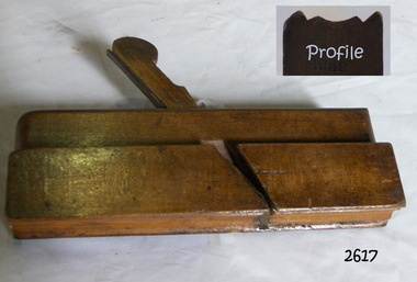 Flagstaff Hill Maritime Museum and Village
Tool - Wood Moulding Plane, 1770-1809
The story of Christopher Gabriel born on April 2, 1746, in Falmouth England is a tale of a poor boy who made good. Shortly before he turned thirteen years of age in 1759 he was apprenticed to a local master carpenter, recorded as a Mr Barnicot the master trained his apprentice well as we can assume by Christopher's later successes. The apprenticeship ended in 1766 after seven years when Christopher reached twenty. Then in 1768, he relocated to London walking the two hundred miles from Falmouth carrying his possessions in a sack. He no sooner arrived in London when he met Alice Trowell who became his wife in March 1769. They set up house on Albermarie Street Clerkenwell and by the first of 1770, Gabriel had begun his business of plane making. It has been speculated that Gabriel took over the shop of John Cogdell aided with an investment from his in-laws of 131 pounds. He went on to prosper as a plane-maker and lumber merchant over the next forty years. His business did well and in 1774 Gabriel moved to a house in Golden Lane, London and 1779 moved again to a home in Ould Street London. By now Gabriel was making a name for himself and his business at this time was located at 32 Banner Street Golden Lane, the following year he purchased another home in Banner Street and 1793 purchased the house next door. At the time of his death in 1808, he owned twenty-seven houses and commercial building. Christopher Gabriel s descendants became quite prominent in England and his grandson, Sir Thomas Gabriel became the Sheriff of London and Middlesex in 1859 and the Lord Mayor of London 1866 and 1867. Gabriel was an extremely prolific plane-maker with a lot of examples made in the 18th century can still be found today. He made good quality tools and was an innovator of several new plane designs. A vintage tool made by a well-known plane-maker, this item was made commercially for firms and individuals that worked in wood and needed a tool that could give a decorative finish to timber. These planes came in various shapes and sizes to achieve a finish to timber surfaces and came in many sizes. A significant Christopher Gabriel plane from the mid to late 18th century that after 200 years can still be used today. Planes made by Gabriel are eagerly sought after by collectors. The tool gives us a snapshot of how furniture and other finishes were created on timber by the use of cutting edged hand tools. Tools that were themselves hand made shows the craftsmanship used during this time not only to make a tool such as the subject item but also the craftsmanship needed to produce a decorative or even finish that was needed for the finishing of timber items. Moulding multi patterned plane has a "5" long bladeStamped Maker C Gabriel (owner JB).flagstaff hill, warrnambool, shipwrecked-coast, flagstaff-hill, flagstaff-hill-maritime-museum, maritime-museum, shipwreck-coast, flagstaff-hill-maritime-village, side rabbet plane, gabriel m hobling -
 Eltham District Historical Society Inc
Negative - Photograph, Popular Picnicing at Hurstbridge, c.1925
Picnickers enjoying a Sunday outing near the Wattle Valley Estate at Hurstbridge. Copied from brochure "Wattle Valley Estate". It is believed the picture is taken at the northwest corner of the intersection of Wattletree Road and Hurstbridge-Arthurs Creek Road looking southeast towards the township (most likely where the house is located on the property of what is today No. 2 Wattletree Road)- https://goo.gl/maps/VDorwCe1rJJUapjE6 According to a comment by Jean Verso (via @nillumbikcouncil FB page 3 Jan 2020) - "This view is from Wattle Tree Road with Haleys Gully Road to the right and across the creek to William Gray's nursery at Allwood. The building to the far left looks like Dorset House. The building on the left in the middle distance is still there today and has been used for storage and as a stable/tack room for a number of years." The Wattle Valley Estate was first advertised in August 1925 as weekend building allotments by the Greater Melbourne Land and Development Company. Advertised from £28.10.0 or £60 per block. In August 1926, 30 picked allotments of 60x150 feet were put up for auction Saturday August 14, 1926 with frontages to Valley View Road and Fawkner Crescent advertised in the “Heart of the Glorious Wattle Country” and “Within 15 Minutes of the Newly Electrified Railway Station”. The Advertiser on August 13, 1926 in an article promoting the auction stated “the estate is regarded as one of the best in the district, and will be sold practically without reserve.” It is noted that an advertisement running in The Argus February 22, 1951 offered the remaining 16 blocks for sale at £12.10.0 or £200 the lot. By March 7, the remaining blocks were advertised at £17.10.0 The Wattle Valley Estate took over 20 years to sell and then people could not build on them Cross Ref EDHS_02665 Rose Series Postcard P. 4341, "View at Hurstbridge, Vic." Also, other images from sales brochure SEPP_1055 / 1056This photo forms part of a collection of photographs gathered by the Shire of Eltham for their centenary project book,"Pioneers and Painters: 100 years of the Shire of Eltham" by Alan Marshall (1971). The collection of over 500 images is held in partnership between Eltham District Historical Society and Yarra Plenty Regional Library (Eltham Library) and is now formally known as the 'The Shire of Eltham Pioneers Photograph Collection.' It is significant in being the first community sourced collection representing the places and people of the Shire's first one hundred years.Digital image 4 x 5 inch B&W Neg1925, dorset house, fawkner crescent, haleys gully road, hurstbridge, hurstbridge-arthurs creek road, picnic, postcards, shire of eltham pioneers photograph collection, valley view road, wattle valley estate, wattletree road, exhibition yprl 2019-12