Showing 8709 items matching "park road"
-
 Greensborough Historical Society
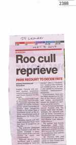
Newspaper Clipping, Roo cull reprieve, 04/11/2015
A recount of kangaroo numbers at Gresswell Forest Reserve Bundoora will decide whether the population should be reduced.News clipping, black text.Date written on clippingbundoora, kangaroos, parks victoria, gresswell forest reserve -
 Greensborough Historical Society
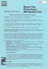
Newsletter, Melbourne & Metropolitan Board of Works, Master Plan Plenty Gorge Metropolitan Park, 1991_06
The Parks Division of the Board was responsible for the preparation of a Master Plan for the management of the Plenty Gorge Metropolitan Park, comprising privately owned land and land owned by the Board and councils.The creation of the park by the Victorian government, to be managed by the Board of Works, guaranteed public access to a large area of land adjacent to the Plenty River Gorge.2p. newsletter, black ink on blue paperNewsletter No. 6plenty gorge park, plenty river -
 Greensborough Historical Society
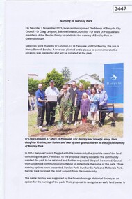
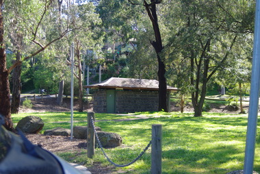
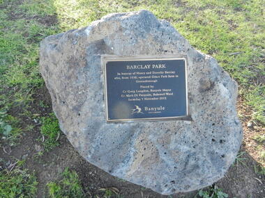
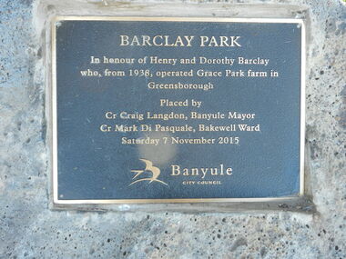
Article, Naming of Barclay Park, 07/11/2015
Formerly McKenzie Park Greensborough; renamed Barclay Park 7 November 2015. Named for the Barclay family who farmed in this area.2p., col. photograph.barclay park greensborough, barclay family -
![Photograph - Digital image, Kelly Garden Supplies [Greensborough], 02/05/2013](/media/collectors/4f729f5697f83e03086015b8/items/5729bced2162f108e8de6b52/item-media/5729bd212162f108e8de74aa/item-fit-380x285.jpg) Greensborough Historical Society
Greensborough Historical SocietyPhotograph - Digital image, Kelly Garden Supplies [Greensborough], 02/05/2013
This photograph of the former site of Kelly Garden Supplies was taken in 2013 to show changes over 40 years, based on Ron Reynold’s sketches in the 1973 publication “Greensborough and Greenhills” published by Cypress Books. The site is now part of the Civic roundabout at the top of the Greensborough By-pass. Civic Drive was associated with the building of Diamond Valley Council Offices opened by Governor Rohan Delacombe on 26/2/1972. Previously it was known as Kelly's Track which wound its way around to a house that overlooked the aqueduct bridge. Kelly's Sandpit (quarry) was the local go to place to obtain road, driveway fill and red sand for local construction. For 80 years previous Kelly's quarry supplied sand to the greater Melbourne area for the surfacing of school grounds, parks etc. Digital copy of colour photograph.greensborough and greenhills, civic drive greensborough, kelly garden supplies, ron reynolds -
 Greensborough Historical Society
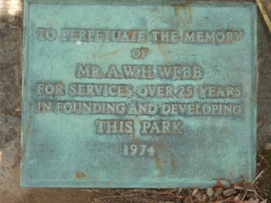
Photograph - Digital Image, Plaque - Greensborough Lower Park, 1974_
Photograph of Plaque located in Greensborough's Lower Park. The inscription reads: "To perpetuate the memory of Mr.A.W.H.Webb for services over 25 years in founding and developing this park 1974"Digital copy of colour photograph.greensborough, lower park greensborough -
 Greensborough Historical Society
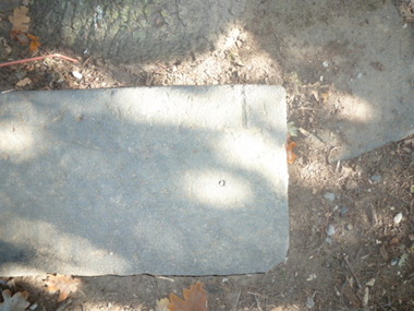
Photograph - Digital image, Park stones, Greensborough Lower Park, 02/05/2013
Photograph of stones located in Greensborough's Lower Park.Digital copy of colour photographs. -
 Greensborough Historical Society
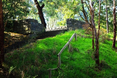
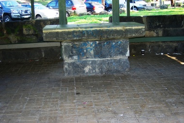
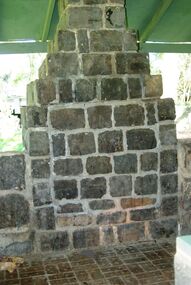
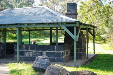
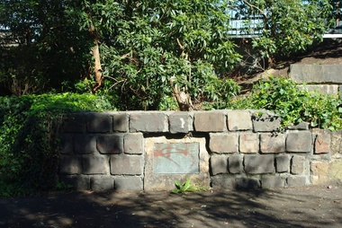
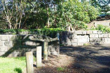
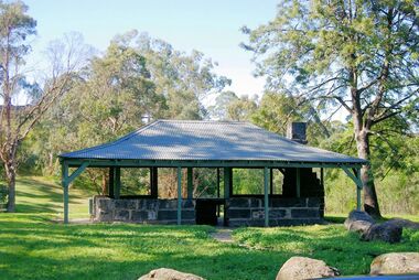
Photograph - Digital Image, Pioneer Reserve 2014 -1, 21/05/2014
Pioneer Reserve, Greensborough is a small park on the corner of St Helena and Diamond Creek Roads. It is adjacent to the site of Greensborough's first bridge across the Plenty River, c. 1864 - 1960s. The shelter, viewing platform, retaining wall and entrance are built from the bridge's massive bluestone arched abutments dismantled between 1974 and 1983. Pioneer Reserve is historically significant for its formative association with noted local landscape designer Gordon Ford in 1968, and it is likely that remnant large field stones at the entrance drive to the Reserve remain from his design. Photograph by Marilyn Smith 2014.Digital copy of colour photograph. -
 Greensborough Historical Society
Photograph - Digital Image, Pioneer Reserve 2014 -2, 01/10/2014
Pioneer Reserve, Greensborough is a small park on the corner of St Helena and Diamond Creek Roads. It is adjacent to the site of Greensborough's first bridge across the Plenty River, c. 1864 - 1960s. The shelter, viewing platform, retaining wall and entrance are built from the bridge's massive bluestone arched abutments dismantled between 1974 and 1983. Photograph by Marilyn Smith 2014.Digital copy of colour photograph.pioneer reserve greensborough -
 Greensborough Historical Society
Photograph - Digital Image, Pioneer Reserve 2014 -3, 01/10/2014
Pioneer Reserve, Greensborough is a small park on the corner of St Helena and Diamond Creek Roads. It is adjacent to the site of Greensborough's first bridge across the Plenty River, c. 1864 - 1960s. The shelter, viewing platform, retaining wall and entrance are built from the bridge's massive bluestone arched abutments dismantled between 1974 and 1983. Photograph by Marilyn Smith 2014.Digital copy of colour photograph.pioneer reserve greensborough -
 Greensborough Historical Society
Photograph - Digital Image, Pioneer Reserve 2014 -4, 23/09/2014
Pioneer Reserve, Greensborough is a small park on the corner of St Helena and Diamond Creek Roads. It is adjacent to the site of Greensborough's first bridge across the Plenty River, c. 1864 - 1960s. The shelter, viewing platform, retaining wall and entrance are built from the bridge's massive bluestone arched abutments dismantled between 1974 and 1983. Photograph by Marilyn Smith 2014.Digital copy of colour photograph.pioneer reserve greensborough -
 Greensborough Historical Society
Photograph - Digital Image, Pioneer Reserve 2014 -5, 23/09/2014
Pioneer Reserve, Greensborough is a small park on the corner of St Helena and Diamond Creek Roads. It is adjacent to the site of Greensborough's first bridge across the Plenty River, c. 1864 - 1960s. The shelter, viewing platform, retaining wall and entrance are built from the bridge's massive bluestone arched abutments dismantled between 1974 and 1983. Photograph by Marilyn Smith 2014.Digital copy of colour photograph.pioneer reserve greensborough -
 Greensborough Historical Society
Photograph - Digital Image, Pioneer Reserve 2014 -6, 23/09/2014
Pioneer Reserve, Greensborough is a small park on the corner of St Helena and Diamond Creek Roads. It is adjacent to the site of Greensborough's first bridge across the Plenty River, c. 1864 - 1960s. The shelter, viewing platform, retaining wall and entrance are built from the bridge's massive bluestone arched abutments dismantled between 1974 and 1983. Photograph by Marilyn Smith 2014.Digital copy of colour photograph.pioneer reserve greensborough -
 Greensborough Historical Society
Photograph - Digital Image, Pioneer Reserve 2014, 23/09/2014
Pioneer Reserve, Greensborough is a small park on the corner of St Helena and Diamond Creek Roads. It is adjacent to the site of Greensborough's first bridge across the Plenty River, c. 1864 - 1960s. The shelter, viewing platform, retaining wall and entrance are built from the bridge's massive bluestone arched abutments dismantled between 1974 and 1983. Photograph by Marilyn Smith 2014.Digital copy of colour photograph.pioneer reserve greensborough -
 Greensborough Historical Society
Photograph - Digital Image, Pioneer Reserve 2014 -8, 23/09/2014
Pioneer Reserve, Greensborough is a small park on the corner of St Helena and Diamond Creek Roads. It is adjacent to the site of Greensborough's first bridge across the Plenty River, c. 1864 - 1960s. The shelter, viewing platform, retaining wall and entrance are built from the bridge's massive bluestone arched abutments dismantled between 1974 and 1983. Photograph by Marilyn Smith 2014.Digital copy of colour photograph.pioneer reserve greensborough -
 Greensborough Historical Society
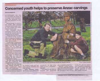
Newspaper Clipping, Concerned youth helps to preserve Anzac carvings, 11/09/2013
A Watsonia schoolboy expressed his concern over the state of some of the carvings in Greensborough War Memorial Park. The chainsaw carvings were completed by artist Leigh Conkie over 10 years ago. A Banyule Council spokesman said inspections and maintenance were ongoing.News clipping, black text, colour image.leigh conkie, greensborough war memorial park, chainsaw sculptures -
 Greensborough Historical Society
Newspaper Clipping, Musical treat for shoppers, 02/04/2014
Were Street Montmorency hosts musical groups each month in the 'Music in the Park' program. Groups mentioned are Black Cat Bone and Jack Nicholson Trio.News clipping, black text, colour image.were street montmorency, music in the park, montmorency traders association -
 Greensborough Historical Society
Newspaper clippings, Diamond Valley News, Collection of news articles on Greensborough War Memorial Park, 1964-1967
Collection of news articles from 1964-1967 on Greensborough War Memorial Park and the eventual dissolution of the War Memorial Trust.6 photocopied pages.greensborough war memorial park, war memorial trust -
 Greensborough Historical Society
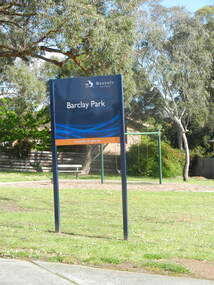
Photograph - Digital Image, Barclay Park Greensborough sign 1, 25/09/2016
Sign at Barclay Park Greensborough 2016Digital copy of colour photographbarclay park greensborough -
 Greensborough Historical Society
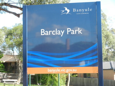
Photograph - Digital Image, Barclay Park Greensborough sign 2, 25/09/2016
Close up of sign at Barclay Park Greensborough 2016Digital copy of colour photographbarclay park greensborough -
 Greensborough Historical Society
Photograph - Digital Image, Barclay Park Greensborough plaque 1, 25/09/2016
Plaque at Barclay Park Greensborough 2016Digital copy of colour photographbarclay park -
 Greensborough Historical Society
Photograph - Digital Image, Barclay Park Greensborough plaque 1, 25/09/2016
Close up of plaque at Barclay Park Greensborough 2016Digital copy of colour photographbarclay park greensborough -
 Greensborough Historical Society
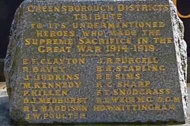
Photograph - Digital image, Marilyn Smith, Fallen Soldier's Memorial inscription, 1914-1919
This close up view of the inscription on the Greensborough Fallen Soldier's Memorial shows the names of the local men who were killed in World War I. The memorial now stands in Greensborough War Memorial Park.Digital copy of colour photo.fallen soldiers memorial greensborough, world war 1 -
 Greensborough Historical Society
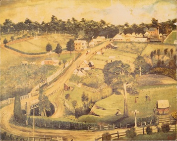
Print, Greensborough 1889 / Arthur Elliott, 1889_
Mounted print of "Greensborough 1889 painted by Arthur Elliott". Shows Main Street Greensborough with the Methodist Church in upper right corner, Lower Park and bluestone bridge in foreground.A view of rural Greensborough 1889.Print of painting, mounted on masonite.main street greensborough, arthur elliott -
 Greensborough Historical Society
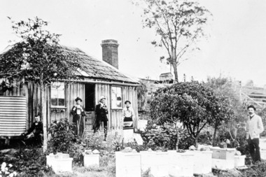
Photograph - Digital Image, Mitchell's house, 1910c
The Mitchell house was situated in Hailes Street on land that went to the river. Part of this land is now the skate park in Yando Street off Kalparrin LaneDigital copy of black and white photograph.mitchell family, hailes street greensborough -
![Photograph - Digital image, Willis Vale [2], 1950c](/media/collectors/4f729f5697f83e03086015b8/items/54fd41442162f10d30bf885f/item-media/54fd41912162f10d30bf8caa/item-fit-380x285.jpg) Greensborough Historical Society
Greensborough Historical SocietyPhotograph - Digital image, Willis Vale [2], 1950c
View of Greensborough in the distance from Willis Vale and surrounding land: House built by Edward Maygar, The flowering Hawthorne Bushes were planted by William Partington. Note the prominent house on upper right where Robert Whatmough lived in the mid 19th century and later sold to Partington family. It was located on the Plenty River across from Partington's Flat. The derelict Willis Vale house was destroyed in 1964 when a fire originating from North Plenty Gorge - Kurrak Road - was lit by two teenage boys and made its way several kilometres down to Partington's Flat Greensborough. In 1946, Alan Partington built the Alwyn Farmhouse in place of the original Robert Whatmough home seen in this photo which became Whatmough Park circa 1976.Home of the Partington familyDigital copy of black and white photograph.willis vale, partington family, maygar family, whatmough -
 Greensborough Historical Society
Photographs, Photographs by Maria Barbaro, 2009_
A collection of over 170 photographs taken by artist Maria Barbaro as studies for her paintings. Taken in the Greensborough area, photos cover a wide range of natural and built landscapes, including the Plenty River; parks and gardens; the Greensborough Hotel; Ashmead; Greensborough railway station.A variety of photographs of the Greensborough area in the early 21st Century.Folder containing approx 150 colour photographs of Greensborough area. Each photograph 10x15cmmaria barbaro, greensborough -
 Greensborough Historical Society
Photograph - Digital image, Trevor Partington's Property, 1960c
Property owned by Trevor Partington. The property was about 1 and three quarter acres on which was a large old and big house which Trevor partitioned into two to have tenant in the back. He used to have horse grazing on the grass. The property was at the lower eastern end of the old 'Church Street' which today is the lowest part of 'The Greensborough Plaza' car park.Digital copy of black and white photograph.trevor partington -
 Greensborough Historical Society
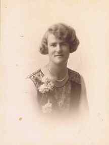
Photograph - Digital image, Jean Partington, 1925c
Miss Jean Partington (1903-1992) was Headmistress at Preston Girls’ School. She lived in the family home at 25 Hailes Street until it was demolished for Greensborough Plaza. Her ashes were spread at the old oak tree, next to the railway line, opposite her old home site which in 2017 is the site of the McDonald's franchise in the Greensborough Plaza car park.Digital copy of black and white studio photograph.jean partington -
 Greensborough Historical Society
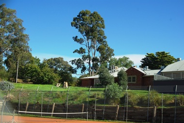
Photograph - Digital image, Alwyn and tennis court 2014, 21/05/2014
In about 1945, Alan and Wyn Partington built a house (Alwyn) on 12 acres (now Whatmough Park) but this land was acquired by the Council for parkland and sports ovals. Digital copy of colour photograph.alwyn, alan partington, whatmough park -
 Greensborough Historical Society
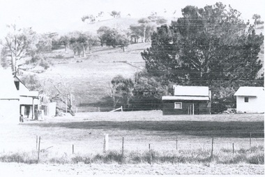
Photograph, Partington's Flat Greensborough Circa 1968, 1968_
Partington's Flat Greensborough was created in the 1950s when Heidelberg Council bought 12 acres from the Partington family to make the park. Fruit trees can be seen in this photograph. Gary Partington (on 2/2/2017) was hazy on the precise locale of the photo. It may have been a track from Willis Vale house going toward the Plenty River with maybe Marsh's Pine trees in the right background defining the border fence line of the Marsh Farm.Colour photographHandwritten on back "Partington's Flat Greensborough about 1968"alan partington, greensborough, partingtons flat, farms, landscapes, gardens