Showing 2335 items matching "city planning"
-
 Kew Historical Society Inc
Plan, Melbourne & Metropolitan Board of Works : Borough of Kew : Detail Plan No.1571, 1904
The Melbourne and Metropolitan Board of Works (MMBW) plans were produced from the 1890s to the 1950s. They were crucial to the design and development of Melbourne's sewerage and drainage system. The plans, at a scale of 40 feet to 1 inch (1:480), provide a detailed historical record of Melbourne streetscapes and environmental features. Each plan covers one or two street blocks (roughly six streets), showing details of buildings, including garden layouts and ownership boundaries, and features such as laneways, drains, bridges, parks, municipal boundaries and other prominent landmarks as they existed at the time each plan was produced. (Source: State Library of Victoria)This plan forms part of a large group of MMBW plans and maps that was donated to the Society by the Mr Poulter, City Engineer of the City of Kew in 1989. Within this collection, thirty-five hand-coloured plans, backed with linen, are of statewide significance as they include annotations that provide details of construction materials used in buildings in the first decade of the 20th century as well as additional information about land ownership and usage. The copies in the Public Record Office Victoria and the State Library of Victoria are monochrome versions which do not denote building materials so that the maps in this collection are invaluable and unique tools for researchers and heritage consultants. A number of the plans are not held in the collection of the State Library of Victoria so they have the additional attribute of rarity.Original survey plan, issued by the MMBW to a contractor with responsibility for constructing sewers in the area identified on the plan within the Borough of Kew. The plan was at some stage hand-coloured, possibly by the contractor, but more likely by officers working in the Engineering Department of the Borough and later Town, then City of Kew. The hand-coloured sections of buildings on the plan were used to denote masonry or brick constructions (pink), weatherboard constructions (yellow), and public buildings (grey). This plan is the other half of Plan No.1571 representing the constructions to the west of Wellington Street before and in 1903/4. This plan represents the built environment in Edgevale Road, Wellington Street, Atkins Street, Annadale Street, Mortimer Street, and Cotham Road. Whereas there are smaller allotments and more modest housing stock facing Edgevale Road, larger blocks and more substantial houses are represented facing Cotham Road.melbourne and metropolitan board of works, detail plans, mmbw 1571, cartography -
 Kew Historical Society Inc
Plan, Melbourne & Metropolitan Board of Works : Borough of Kew : Detail Plan No.1572, 1905
The Melbourne and Metropolitan Board of Works (MMBW) plans were produced from the 1890s to the 1950s. They were crucial to the design and development of Melbourne's sewerage and drainage system. The plans, at a scale of 40 feet to 1 inch (1:480), provide a detailed historical record of Melbourne streetscapes and environmental features. Each plan covers one or two street blocks (roughly six streets), showing details of buildings, including garden layouts and ownership boundaries, and features such as laneways, drains, bridges, parks, municipal boundaries and other prominent landmarks as they existed at the time each plan was produced. (Source: State Library of Victoria)This plan forms part of a large group of MMBW plans and maps that was donated to the Society by the Mr Poulter, City Engineer of the City of Kew in 1989. Within this collection, thirty-five hand-coloured plans, backed with linen, are of statewide significance as they include annotations that provide details of construction materials used in buildings in the first decade of the 20th century as well as additional information about land ownership and usage. The copies in the Public Record Office Victoria and the State Library of Victoria are monochrome versions which do not denote building materials so that the maps in this collection are invaluable and unique tools for researchers and heritage consultants. A number of the plans are not held in the collection of the State Library of Victoria so they have the additional attribute of rarity.Original survey plan, issued by the MMBW to a contractor with responsibility for constructing sewers in the area identified on the plan within the Borough of Kew. The plan was at some stage hand-coloured, possibly by the contractor, but more likely by officers working in the Engineering Department of the Borough and later Town, then City of Kew. The hand-coloured sections of buildings on the plan were used to denote masonry or brick constructions (pink), weatherboard constructions (yellow), and public buildings (grey). Plan No. 1572 represents the built environment bordered by Barkers Road, Wrixon Street, Edgevale Road and Fitzwilliam Street. Other streets identified on the plan include Stansell Street. Plan 1572 shows that by 1903-05, there was only patchy development in this area of Kew, mainly on Edgevale Road and Fitzwilliam Street. Only two named houses are identified: the quaintly named ‘Tweed Cottage’, and ‘Mendip’. The earliest reference to Treed Cottage in Australian newspapers is to the death of Walter Thompson, aged 74 who was a resident there in 1885. His youngest daughter was to die there in 1908. Mendip to the north of Tweed Cottage was owned by Henry Thompson; he was to die in 1901; his wife in 1932. At this period of time, Malin Street and Clivedon Court did not extend to Barkers Road.melbourne and metropolitan board of works, detail plans, mmbw 1572, cartography -
 Kew Historical Society Inc
Plan, Melbourne & Metropolitan Board of Works : Borough of Kew : Detail Plan No.1573, 1905
The Melbourne and Metropolitan Board of Works (MMBW) plans were produced from the 1890s to the 1950s. They were crucial to the design and development of Melbourne's sewerage and drainage system. The plans, at a scale of 40 feet to 1 inch (1:480), provide a detailed historical record of Melbourne streetscapes and environmental features. Each plan covers one or two street blocks (roughly six streets), showing details of buildings, including garden layouts and ownership boundaries, and features such as laneways, drains, bridges, parks, municipal boundaries and other prominent landmarks as they existed at the time each plan was produced. (Source: State Library of Victoria)This plan forms part of a large group of MMBW plans and maps that was donated to the Society by the Mr Poulter, City Engineer of the City of Kew in 1989. Within this collection, thirty-five hand-coloured plans, backed with linen, are of statewide significance as they include annotations that provide details of construction materials used in buildings in the first decade of the 20th century as well as additional information about land ownership and usage. The copies in the Public Record Office Victoria and the State Library of Victoria are monochrome versions which do not denote building materials so that the maps in this collection are invaluable and unique tools for researchers and heritage consultants. A number of the plans are not held in the collection of the State Library of Victoria so they have the additional attribute of rarity.Original survey plan, issued by the MMBW to a contractor with responsibility for constructing sewers in the area identified on the plan within the Borough of Kew. The plan was at some stage hand-coloured, possibly by the contractor, but more likely by officers working in the Engineering Department of the Borough and later Town, then City of Kew. The hand-coloured sections of buildings on the plan were used to denote masonry or brick constructions (pink), weatherboard constructions (yellow), and public buildings (grey). This plan has detailed annotations written in red or blue ink, showing prices, which may be the annual valuations of the properties, and some owners’ names, a most unusual feature on contractor's maps. Some areas, such as the buildings of Methodist Ladies’ College (MLC), include the school’s tennis court and swimming pool, but are not coloured to show building materials – did the draftsman just run out of time, or ink, or enthusiasm, before his plan had to be submitted? MLC had been founded in 1882 as a ‘modern school of the first order’ with buildings that formed ‘a collegiate institution for girls unsurpassed in the colonies’. The goal of its founders was to provide a high-class Christian education for girls, comparable with that provided elsewhere for boys. Some shops are shown along Edgevale Road, though they are not designated as commercial premises. Larger houses are depicted, including ‘Fairlawn’ in Barkers Road, and ‘Clevedon’ and ‘Rosehill’ (now demolished) in Fitzwilliam Street.melbourne and metropolitan board of works, detail plans, mmbw 1573, maps - borough of kew, cartography -
 Kew Historical Society Inc
Plan, Melbourne & Metropolitan Board of Works : Borough of Kew : Detail Plan No.1574, 1905
The Melbourne and Metropolitan Board of Works (MMBW) plans were produced from the 1890s to the 1950s. They were crucial to the design and development of Melbourne's sewerage and drainage system. The plans, at a scale of 40 feet to 1 inch (1:480), provide a detailed historical record of Melbourne streetscapes and environmental features. Each plan covers one or two street blocks (roughly six streets), showing details of buildings, including garden layouts and ownership boundaries, and features such as laneways, drains, bridges, parks, municipal boundaries and other prominent landmarks as they existed at the time each plan was produced. (Source: State Library of Victoria)This plan forms part of a large group of MMBW plans and maps that was donated to the Society by the Mr Poulter, City Engineer of the City of Kew in 1989. Within this collection, thirty-five hand-coloured plans, backed with linen, are of statewide significance as they include annotations that provide details of construction materials used in buildings in the first decade of the 20th century as well as additional information about land ownership and usage. The copies in the Public Record Office Victoria and the State Library of Victoria are monochrome versions which do not denote building materials so that the maps in this collection are invaluable and unique tools for researchers and heritage consultants. A number of the plans are not held in the collection of the State Library of Victoria so they have the additional attribute of rarity.Original survey plan, issued by the MMBW to a contractor with responsibility for constructing sewers in the area identified on the plan within the Borough of Kew. The plan was at some stage hand-coloured, possibly by the contractor, but more likely by officers working in the Engineering Department of the Borough and later Town, then City of Kew. The hand-coloured sections of buildings on the plan were used to denote masonry or brick constructions (pink), weatherboard constructions (yellow), and public buildings (grey). This plan shows several very large houses, particularly along Glenferrie Road, and the area now occupied by Ruyton Girls’ School. ‘Tarring’ (incorrectly spelled here as ‘Karring’) was built for Henry Henty in 1872, on part of his original allotment of 20 acres, and ‘Mount View’, which retains its original building and the fountain in the front garden, is part of Ruyton’s Junior School. The most significant change to Tarring and its grounds since 1903, involve the removal of a number of the outbuildings, including a Burmese temple, bought by Henty from the Burmese Exhibit at the Great Exhibition of 1880. It is shown on the plan as a summerhouse. The two-storey mansion, on the corner of Glenferrie Road and Wellington Street, was built in 1891 by leading architect Alfred White as his own home. Having an initial N.A.V. of £160, the house was purchased by a warehouseman Henry Lister, by 1900, when the N.A.V. was recorded at £111. By the turn of the century the house was known as ‘Comaques’. By contrast, much smaller houses are shown in Scott and Byron Streets, including a tiny Mission Hall in Byron Street, which belonged to the Anglican Church from at least 1903 to 1917.melbourne and metropolitan board of works, detail plans, maps - borough of kew, mmbw 1574, cartography -
 Kew Historical Society Inc
Plan, Melbourne & Metropolitan Board of Works : Borough of Kew : Detail Plan No.1575, 1905
The Melbourne and Metropolitan Board of Works (MMBW) plans were produced from the 1890s to the 1950s. They were crucial to the design and development of Melbourne's sewerage and drainage system. The plans, at a scale of 40 feet to 1 inch (1:480), provide a detailed historical record of Melbourne streetscapes and environmental features. Each plan covers one or two street blocks (roughly six streets), showing details of buildings, including garden layouts and ownership boundaries, and features such as laneways, drains, bridges, parks, municipal boundaries and other prominent landmarks as they existed at the time each plan was produced. (Source: State Library of Victoria)This plan forms part of a large group of MMBW plans and maps that was donated to the Society by the Mr Poulter, City Engineer of the City of Kew in 1989. Within this collection, thirty-five hand-coloured plans, backed with linen, are of statewide significance as they include annotations that provide details of construction materials used in buildings in the first decade of the 20th century as well as additional information about land ownership and usage. The copies in the Public Record Office Victoria and the State Library of Victoria are monochrome versions which do not denote building materials so that the maps in this collection are invaluable and unique tools for researchers and heritage consultants. A number of the plans are not held in the collection of the State Library of Victoria so they have the additional attribute of rarity.Original survey plan, issued by the MMBW to a contractor with responsibility for constructing sewers in the area identified on the plan within the Borough of Kew. The plan was at some stage hand-coloured, possibly by the contractor, but more likely by officers working in the Engineering Department of the Borough and later Town, then City of Kew. The hand-coloured sections of buildings on the plan were used to denote masonry or brick constructions (pink), weatherboard constructions (yellow), and public buildings (grey). Plan No.1575 shows that in the area bounded by Wellington Street, Edgevale Road, Glenferrie Road, and Cotham Road, there had already been significant subdivision of land and houses constructed. As one of the highest points in Kew, as expected, there were already some significant mansions built on large allotments of land. Many of these mansions are identified by name on the plan such as ‘Kelso’, ‘Abbotsford’, ‘Clarendon’ and ‘Ashlyn’ in Cotham Road. Other houses of equal size are unnamed on the plan.melbourne and metropolitan board of works, detail plans, maps - borough of kew, mmbw 1575, cartography -
 Kew Historical Society Inc
Photograph, Stuart Tompkins Studio, Electricity Supply Poles, North Road, Ormond, 1965
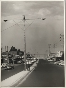
Research provided by Stuart Tompkins Studio, Box Hill, into alternatives for median strip street lighting to be used in Burke Road, Kew. The photographers identified variants in different suburbs appropriate to Kew's needs.The series from which the photograph is drawn provides a snapshot by a commercial photographic studio of each named vicinity in 1965 as well as providing examples of public works infrastructure being commissioned by local government in the 1960s. The photos originally formed part of the Engineering Department's files in the City of Kew before being donated to the kew Historical Society.Electricity Supply Poles, North Road, Ormond, 1965. Electricity supply poles photographed for the Kew City Council by Stuart Tompkins Studio. The photograph of North Road, Ormond west of Jasper Road, looking east depicts wooden poles carrying two lamps in a median strip and with two on each side alternately. It was noted that the supply wires were from one side only. The poles were described as 3′ above ground and 11.25″ in diameter. The plan was to use this approach for Burke Road, Kew. [There are three copies of this photograph in the Collection.] Typed inscription on reverse: "Electricity Supply Poles. Photographed for Kew City Council 8/2/65. No.1 North Road - Ormond, west of Jasper Road, looking east. Wooden poles carrying two lamps in median strip and two on each side alternately just as is proposed for Burke Road, Kew. Supply wires from one side only. Poles 3' above ground 11 1/4" dia." Studio stamp: "Stuart Tompkins Studio. 547 Station Street, Box Hill. WX1439."stuart tompkins studio, street lighting, south road (moorabin) 1965, public infrastructure -- city of kew, city of kew -- engineer's department -
 Kew Historical Society Inc
Photograph, Stuart Tompkins Studio, Electricity Supply Poles, North Road, Ormond, 1965
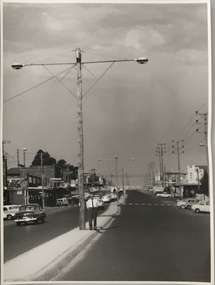
Research provided by Stuart Tompkins Studio, Box Hill, into alternatives for median strip street lighting to be used in Burke Road, Kew. The photographers identified variants in different suburbs appropriate to Kew's needs.The series from which the photograph is drawn provides a snapshot by a commercial photographic studio of each named vicinity in 1965 as well as providing examples of public works infrastructure being commissioned by local government in the 1960s. The photos originally formed part of the Engineering Department's files in the City of Kew before being donated to the kew Historical Society.Electricity Supply Poles, North Road, Ormond, 1965. Electricity supply poles photographed for the Kew City Council by Stuart Tompkins Studio. The photograph of North Road, Ormond west of Jasper Road, looking east depicts wooden poles carrying two lamps in a median strip and with two on each side alternately. It was noted that the supply wires were from one side only. The poles were described as 3′ above ground and 11.25″ in diameter. The plan was to use this approach for Burke Road, Kew. [There are three copies of this photograph in the Collection.] Typed inscription on reverse: "Electricity Supply Poles. Photographed for Kew City Council 8/2/65. No.1 North Road - Ormond, west of Jasper Road, looking east. Wooden poles carrying two lamps in median strip and two on each side alternately just as is proposed for Burke Road, Kew. Supply wires from one side only. Poles 3' above ground 11 1/4" dia." Studio stamp: "Stuart Tompkins Studio. 547 Station Street, Box Hill. WX1439."stuart tompkins studio, street lighting, south road (moorabin) 1965 -
 Kew Historical Society Inc
Photograph, Stuart Tompkins Studio, Electricity Supply Poles, North Road, Ormond, 1965
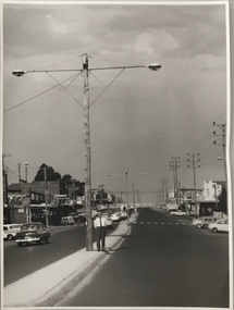
Research provided by Stuart Tompkins Studio, Box Hill, into alternatives for median strip street lighting to be used in Burke Road, Kew. The photographers identified variants in different suburbs appropriate to Kew's needs.The series from which the photograph is drawn provides a snapshot by a commercial photographic studio of each named vicinity in 1965 as well as providing examples of public works infrastructure being commissioned by local government in the 1960s. The photos originally formed part of the Engineering Department's files in the City of Kew before being donated to the kew Historical Society.Electricity Supply Poles, North Road, Ormond, 1965. Electricity supply poles photographed for the Kew City Council by Stuart Tompkins Studio. The photograph of North Road, Ormond west of Jasper Road, looking east depicts wooden poles carrying two lamps in a median strip and with two on each side alternately. It was noted that the supply wires were from one side only. The poles were described as 3′ above ground and 11.25″ in diameter. The plan was to use this approach for Burke Road, Kew. [There are three copies of this photograph in the Collection.] Typed inscription on reverse: "Electricity Supply Poles. Photographed for Kew City Council 8/2/65. No.1 North Road - Ormond, west of Jasper Road, looking east. Wooden poles carrying two lamps in median strip and two on each side alternately just as is proposed for Burke Road, Kew. Supply wires from one side only. Poles 3' above ground 11 1/4" dia." Studio stamp: "Stuart Tompkins Studio. 547 Station Street, Box Hill. WX1439."stuart tompkins studio, street lighting, south road (moorabin) 1965 -
 Freemasons Victoria - Gordon Lodge, 99
Original Gordon Lodge lodge-room 1886
A picture of the original Gordon Lodge lodge-room of 1886 - room currently in use by the Lodge's artist-in-residence. Below is a newspaper article from the North Melbourne Advertiser (Vic: 1873 - 1894) for Friday 22 April 1887 that describes the architecture of the building at the time of its completion. From some of the details included in the article it is obvious that the journalist who wrote the article was a Freemason. THE MASONIC HALL ASCOT VALE North Melbourne Advertiser (Vic. : 1873 - 1894) Friday 22 April 1887 THE MASONIC HALL ASCOT VALE The now Masonic Hall, Ascot Vale, the foundation stone of which was laid by the Worshipful Master of the Gordon Lodge (Bro, W. F. Lamonby) in October last has just been completed, and will be formally opened: with grand Masonic ball on the 13th prox. The hall stands on a fine block of land having a frontage of 50ft to the Maribyrnong road by a depth of 130 ft., and is built of brick and cement on a most substantial foundation of bluestone. The Tuscan style of architecture has been adopted with the most successful result, and the front design which is especially handsome, includes four massive pilasters with frieze architrave and enriched cornice, forming the entablature of the order,- and giving a most imposing appearance. The front door, over which are the masonic emblems, is seven feet wide, and two escape doors made to open outwards in compliance with the Central Board of Health regulations are also provided, in case of emergency. In the vestibule is a very fine elliptic arch with keystone enriched with fruit, and the whole floor, 9ft. 6in. wide, is laid with Cawkwell's encaustic tyles. On the right, of tile vestibule is a commodious committee room 22ft. by 12ft 6in with side entrance for members, so that in case the main hall is engaged no inconvenience need be caused. On the left is the Secretary's room, and off this again is a staircase cellar. The vestibule is well lighted with two exceedingly pretty chandeliers, which have a very pleasing effect and give it a nice bright appearance ascending a handsome staircase leading from the vestibule the upper storey is reached, and here everything is splendidly arranged, especially 'the Lodge Room, which is a model of neatness and of comfort. The dimensions are 28ft. x 22ft 6in. with an elevation of 17ft. 6in. to the beautiful cove ceiling, which is quite a work of art. At the east end of the room on a raised dais is the master's chair with the masonic emblems, and neat forms of polished kauri are placed at the sides for members, about 150 of whom can be accommodated. The lighting and ventilation have both been well attended to and all is very complete. The main hall is 75ft. by 35 ft. with a stage 15ft. deep, leaving the auditorium 60ft. x 35ft. with a seating capacity about 600. Round the walls up to 6ft 6in. is a handsome dado in Portland cement and above it are panelled Tuscan pilasters to the entablature, architrave enriched frieze and medallion cornice forming the main cornice to the hall. Immediately inside the cornice is a sunken panel all-round the ceiling relieved with ornamental outlet ventilators. There are twelve large windows, six on each aide, and the sashes, skirting boards, and doors throughout the building are beautifully painted in imitation of grained cedar. Two enormous gas reflectors, each for 50 lights are suspended from the ceiling and besides these, four elegant hanging chandeliers for lighting up the proscenium, and back of the stage, under which is a storeroom for seats, &c, when the hall is required for a ball. The floor is made of kauri, secretly nailed, and is beautifully finished off. At the back of the stage are two lavatories and ladies and gentlemen's dressing rooms, between which are a connecting passage for a call boy. Outside is a capital asphalted yard, and the other usual conveniences on an improved plan. There is a right-of-way asphalted on each side of the building, and a large lamp is to be placed opposite the main entrance to light up the front. Everything that forethought and ability could suggest to make the hall comfortable and popular has been done, and it now only remains for the public to avail themselves of the advantages offered them by the enterprising Company. The cost of the building and furniture, including a magnificent piano, was £2,500, and the land £300. Mr J. C. M. Cowan, of Ascot Vale, is the architect, and Messrs Parker and Pater, of South Melbourne, the contractors. The plastering was done by Mr I Nicholas, of Murray Street, Moonee Ponds, who is also entitled to great praise for his splendid workmanship. Mr Cowan has been most assiduous and particular in seeing that his instructions were carried out to his satisfaction, and the result must be exceedingly gratifying to him and to the directors. The Masonic hall is only one of the many buildings erected by Mr Cowan in this district, among the others being the well known residences of Meessrs. J. Levy, Mooneo Street; W. Murphy, Eglington street; G. Groube, Maribyrnong street; C. A. Arvier, Moonee Ponds ; and F. Paul, Mount Alexander road. It may also be mentioned that Mr Cowan generously presented the plans for the now local fire brigade tower which is acknowledged to be one of the strongest and most graceful around Melbourne, The new Masonic Hall does infinite credit to the borough, and in accommodation, design, and comfort it is not surpassed by any similar building of the kind outside the city. -
 Kew Historical Society Inc
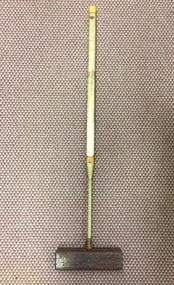
Equipment - Sports Equipment, Auburn Heights Recreation Club, Wooden Croquet Mallet, Twentieth Century
Sports Clubs in Kew in the final decades of the 19th century and in the early 20th century were often umbrella organisations with facilities for a number of sports. Typically in Kew, this included teams in lawn bowls, tennis and croquet. The Kew Bowling Club was formed in 1880 while the privately owned Auburn Heights Recreation Club was opened in 1904. The croquet courts at the Kew Recreation Club were opened in 1906, two years after the Club's formation. By 1998, the two Clubs decided to amalgamate at the Auburn Heights site in Barkers Road, forming the Kew Heights Sports Club. The combined club was itself taken over by the Melbourne Cricket Club in 2012 becoming MCC Kew Sports Club. In 2017 MCC Kew closed and its landholding was subsequently sold to Carey Baptist Grammar School. Both the Kew and Auburn Heights Clubs assembled important collections. These historically significant and large collections were donated to the Society in 2020. The collections include manuscripts, pictures, trophies, plans, honour boards etc. References Barnard FGA 1910, 'Sports and Pastimes' in Jubilee History of Kew Victoria: Its origin & progress 1803-1910. Chapman J & C 1999, The history of the Auburn Heights Recreation Club, 1904 to 1908. Reeve S 2012, City of Boroondara: Thematic Environmental History, p.216.The combined collections of the four sporting clubs making up the collection number hundreds of items that are historically significant locally. They are also significant to the sporting history of the greater Melbourne area and to the sports of lawn bowls and tennis in Australia in the 19th and 20th centuries. The collection illuminates two of the Victorian historic themes - 'Building community life' through forming community organisations and 'Shaping cultural and creative life' by participating in sport and recreation.Croquet mallet, Shaft made of a number of separate rectangular sections of pale wood, mostly wrapped with cotton cord and strips of leather. The rectangular head is made of a darker heavier wood and it is banded with a strip of lighter wood.croquet -- mallets, croquet -- equipment, auburn heights croquet club, auburn heights recreation club -
 Kew Historical Society Inc
Map, MMBW, MMBW Town of Kew, 1910-21
The Melbourne and Metropolitan Board of Works (MMBW) was established by an act of the Victorian Parliament in 1890 to prepare for and to implement a sewerage and water reticulation system across what was then inner Melbourne, its surrounding and middle distance suburbs, including Kew. The MMBW was disbanded in 1991.The map collection of the Kew Historical Society has at its core the historic maps assembled and originally stored in the City Engineer's Department of the City of Kew. These include maps in a number of scales. The vast majority of maps were produced by the MMBW in the first two decades of the twentieth century, and are solid working maps, backed by linen for durability. These maps are historically significant to Kew, the City of Boroondara and to the history of the development of state utilities in Victoria. A number of the Kew maps have additional details added by former municipal officers, including the levels reached by various floods. As these were working documents, information was added to them long after the period of their initial production and distribution.Early map of the Town of Kew, created after 1910, at a scale 440 ft to 1 inch. The 'assembled' map by the City of Kew Engineer's Department includes scaled down copies of The Melbourne and Metropolitan Board of Works maps, Nos. 39, 40, 64, 65, 66, 67, 68, and 117. The map covers the entirety of the Town of Kew, bordered on its north and west by the River Yarra, by Burke Road in the East and Barkers Road in the south. The map shows the extent of urban development by that time, prominent institutions and the outlines of built structures in the municipality. TOWN OF KEW / SCALE 400 FEET TO 1 INCHmelbourne & metropolitan board of works, mmbw maps, mmbw plans, town of kew, cartography -
 Kew Historical Society Inc
Map, MMBW, MMBW Plan No.39 Kew & Heidelberg, 1900-1910
The Melbourne and Metropolitan Board of Works (MMBW) was established by an act of the Victorian Parliament in 1890 to prepare for and to implement a sewerage and water reticulation system across what was then inner Melbourne, its surrounding and middle distance suburbs, including Kew. The MMBW was disbanded in 1991.The map collection of the Kew Historical Society has at its core the historic maps assembled and originally stored in the City Engineer's Department of the City of Kew. These include maps in a number of scales. The vast majority of maps were produced by the MMBW in the first two decades of the twentieth century, and are solid working maps, backed by linen for durability. These maps are historically significant to Kew, the City of Boroondara and to the history of the development of state utilities in Victoria. A number of the Kew maps have additional details added by former municipal officers, including the levels reached by various floods. As these were working documents, information was added to them long after the period of their initial production and distribution.Early map of part of the Borough of Kew, created in the first decade of the twentieth century, at a scale 160 ft to 1 inch. The map covers what was then the north western section of Kew, bordered on its north by Wills Street and the Kew Lunatic Asylum, in the west by the River Yarra [and the later added Yarra Boulevard] , by Princess Street in the East and Holroyd Street in the south. The map shows the extent of urban development by that time, prominent institutions and the outlines of built structures in the municipality. Contour lines were added in ink to the map at a later stage.MELBOURNE AND METROPOLITAN BOARD OF WORKS / PLAN NO. 39 / KEW & HEIDELBERGmelbourne & metropolitan board of works, mmbw maps, mmbw plans, borough of kew, cartography -
 Kew Historical Society Inc
Map, MMBW, MMBW Plan No.40 Collingwood & Kew, 1900-1910
The Melbourne and Metropolitan Board of Works (MMBW) was established by an act of the Victorian Parliament in 1890 to prepare for and to implement a sewerage and water reticulation system across what was then inner Melbourne, its surrounding and middle distance suburbs, including Kew. The MMBW was disbanded in 1991.The map collection of the Kew Historical Society has at its core the historic maps assembled and originally stored in the City Engineer's Department of the City of Kew. These include maps in a number of scales. The vast majority of maps were produced by the MMBW in the first two decades of the twentieth century, and are solid working maps, backed by linen for durability. These maps are historically significant to Kew, the City of Boroondara and to the history of the development of state utilities in Victoria. A number of the Kew maps have additional details added by former municipal officers, including the levels reached by various floods. As these were working documents, information was added to them long after the period of their initial production and distribution.Early map of part of the Borough of Kew, created in the first decade of the twentieth century, at a scale 160 ft to 1 inch. The map covers what was then the south western section of Kew, bordered on its north by Studley Park Road, in the west by Walmer Street and the River Yarra, by High Street South and Princess Street in the East and Barkers Road in the south. The map shows the extent of urban development by that time, prominent institutions and the outlines of built structures in the municipality. Contour lines and historic flood levels were added in ink to the map at a later stage.MELBOURNE AND METROPOLITAN BOARD OF WORKS / PLAN NO. 40 / COLLINGWOOD & KEWmelbourne & metropolitan board of works, mmbw maps, mmbw plans, borough of kew, cartography -
 Kew Historical Society Inc
Map, MMBW, MMBW Plan No.64 Kew & Heidelberg, 1900-1910
The Melbourne and Metropolitan Board of Works (MMBW) was established by an act of the Victorian Parliament in 1890 to prepare for and to implement a sewerage and water reticulation system across what was then inner Melbourne, its surrounding and middle distance suburbs, including Kew. The MMBW was disbanded in 1991.The map collection of the Kew Historical Society has at its core the historic maps assembled and originally stored in the City Engineer's Department of the City of Kew. These include maps in a number of scales. The vast majority of maps were produced by the MMBW in the first two decades of the twentieth century, and are solid working maps, backed by linen for durability. These maps are historically significant to Kew, the City of Boroondara and to the history of the development of state utilities in Victoria. A number of the Kew maps have additional details added by former municipal officers, including the levels reached by various floods. As these were working documents, information was added to them long after the period of their initial production and distribution.Early map of part of the Borough of Kew, created in the first decade of the twentieth century, at a scale 160 ft to 1 inch. The map covers what was then the northern most part of Kew, bordered on its north and west by the Yarra River, in the East by Connor's Creek and by the Asylum in the south. The map shows the extent of urban development by that time, prominent institutions and the outlines of built structures in the municipality. Contour lines and historic flood levels were added in ink to the map at a later stage.MELBOURNE AND METROPOLITAN BOARD OF WORKS / PLAN NO. 64 / KEW & HEIDELBERGmelbourne & metropolitan board of works, mmbw maps, mmbw plans, borough of kew, cartography -
 Kew Historical Society Inc
Map, MMBW, MMBW Plan No.65 Kew & Heidelberg, 1900-1910
The Melbourne and Metropolitan Board of Works (MMBW) was established by an act of the Victorian Parliament in 1890 to prepare for and to implement a sewerage and water reticulation system across what was then inner Melbourne, its surrounding and middle distance suburbs, including Kew. The MMBW was disbanded in 1991.The map collection of the Kew Historical Society has at its core the historic maps assembled and originally stored in the City Engineer's Department of the City of Kew. These include maps in a number of scales. The vast majority of maps were produced by the MMBW in the first two decades of the twentieth century, and are solid working maps, backed by linen for durability. These maps are historically significant to Kew, the City of Boroondara and to the history of the development of state utilities in Victoria. A number of the Kew maps have additional details added by former municipal officers, including the levels reached by various floods. As these were working documents, information was added to them long after the period of their initial production and distribution.Early map of part of the Borough of Kew, created in the first decade of the twentieth century, at a scale 160 ft to 1 inch. The map covers what was then the south central part of Kew, bordered on its north by Malmsbury Street, in the west by Florence Avenue, in the south by Barkers Road, and in the east by Princess Street. The map shows the extent of urban development by that time, prominent institutions and the outlines of built structures in the municipality. Contour lines were added in ink to the map at a later stage.MELBOURNE AND METROPOLITAN BOARD OF WORKS / PLAN NO. 65 / KEW & HEIDELBERGmelbourne & metropolitan board of works, mmbw maps, mmbw plans, borough of kew, cartography -
 Kew Historical Society Inc
Map, MMBW, MMBW Plan No.66 Kew, 1900-1910
The Melbourne and Metropolitan Board of Works (MMBW) was established by an act of the Victorian Parliament in 1890 to prepare for and to implement a sewerage and water reticulation system across what was then inner Melbourne, its surrounding and middle distance suburbs, including Kew. The MMBW was disbanded in 1991.The map collection of the Kew Historical Society has at its core the historic maps assembled and originally stored in the City Engineer's Department of the City of Kew. These include maps in a number of scales. The vast majority of maps were produced by the MMBW in the first two decades of the twentieth century, and are solid working maps, backed by linen for durability. These maps are historically significant to Kew, the City of Boroondara and to the history of the development of state utilities in Victoria. A number of the Kew maps have additional details added by former municipal officers, including the levels reached by various floods. As these were working documents, information was added to them long after the period of their initial production and distribution.Early map of part of the Borough of Kew, created in the first decade of the twentieth century, at a scale 160 ft to 1 inch. The map covers what was then the south eastern part of Kew, bordered on its north by Adeney Avenue, in the west by Sackville Street, in the south by Barkers Road, and in the east by Burke Road. The map shows the extent of urban development by that time, prominent institutions and the outlines of built structures in the municipality. Contour lines were added in ink to the map at a later stage.MELBOURNE AND METROPOLITAN BOARD OF WORKS / PLAN NO. 66 / KEW melbourne & metropolitan board of works, mmbw maps, mmbw plans, borough of kew, cartography -
 Kew Historical Society Inc
Map, MMBW, MMBW Plan No.67 Kew, 1900-1910
The Melbourne and Metropolitan Board of Works (MMBW) was established by an act of the Victorian Parliament in 1890 to prepare for and to implement a sewerage and water reticulation system across what was then inner Melbourne, its surrounding and middle distance suburbs, including Kew. The MMBW was disbanded in 1991.The map collection of the Kew Historical Society has at its core the historic maps assembled and originally stored in the City Engineer's Department of the City of Kew. These include maps in a number of scales. The vast majority of maps were produced by the MMBW in the first two decades of the twentieth century, and are solid working maps, backed by linen for durability. These maps are historically significant to Kew, the City of Boroondara and to the history of the development of state utilities in Victoria. A number of the Kew maps have additional details added by former municipal officers, including the levels reached by various floods. As these were working documents, information was added to them long after the period of their initial production and distribution.Early map of part of the Borough of Kew, created in the first decade of the twentieth century, at a scale 160 ft to 1 inch. The map covers what was then the north central part of Kew, bordered on its north by the Outer Circle Railway Spruzen and Beresford Avenues, in the west by Princess Street, in the south by High Street, and in the east by (about) Belford Road. The map shows the extent of urban development by that time, prominent institutions and the outlines of built structures in the municipality. Contour lines were added in ink to the map at a later stage.MELBOURNE AND METROPOLITAN BOARD OF WORKS / PLAN NO. 67 / KEW melbourne & metropolitan board of works, mmbw maps, mmbw plans, borough of kew, cartography -
 Kew Historical Society Inc
Map, MMBW, MMBW Plan No.68 Kew, 1900-1910
The Melbourne and Metropolitan Board of Works (MMBW) was established by an act of the Victorian Parliament in 1890 to prepare for and to implement a sewerage and water reticulation system across what was then inner Melbourne, its surrounding and middle distance suburbs, including Kew. The MMBW was disbanded in 1991.The map collection of the Kew Historical Society has at its core the historic maps assembled and originally stored in the City Engineer's Department of the City of Kew. These include maps in a number of scales. The vast majority of maps were produced by the MMBW in the first two decades of the twentieth century, and are solid working maps, backed by linen for durability. These maps are historically significant to Kew, the City of Boroondara and to the history of the development of state utilities in Victoria. A number of the Kew maps have additional details added by former municipal officers, including the levels reached by various floods. As these were working documents, information was added to them long after the period of their initial production and distribution.Early map of part of the Borough of Kew, created in the first decade of the twentieth century, at a scale 160 ft to 1 inch. The map covers what was then the north central part of Kew, bordered in the north by Oak Avenue, in the west by the Yarra River and Connor's Creek, in the south by Beresford and Carnegie Avenues, and in the east by Glass's Creek and Burke Road. The map shows the extent of urban development by that time, prominent institutions and the outlines of built structures in the municipality. Contour lines and the levels of historic floods were added in ink to the map at a later stage.MELBOURNE AND METROPOLITAN BOARD OF WORKS / PLAN NO. 68 / KEW melbourne & metropolitan board of works, mmbw maps, mmbw plans, borough of kew, cartography -
 Kew Historical Society Inc
Map, MMBW, MMBW Plan No.117 Heidelberg & Kew, 1900-1910
The Melbourne and Metropolitan Board of Works (MMBW) was established by an act of the Victorian Parliament in 1890 to prepare for and to implement a sewerage and water reticulation system across what was then inner Melbourne, its surrounding and middle distance suburbs, including Kew. The MMBW was disbanded in 1991.The map collection of the Kew Historical Society has at its core the historic maps assembled and originally stored in the City Engineer's Department of the City of Kew. These include maps in a number of scales. The vast majority of maps were produced by the MMBW in the first two decades of the twentieth century, and are solid working maps, backed by linen for durability. These maps are historically significant to Kew, the City of Boroondara and to the history of the development of state utilities in Victoria. A number of the Kew maps have additional details added by former municipal officers, including the levels reached by various floods. As these were working documents, information was added to them long after the period of their initial production and distribution.Early map of part of the Borough of Kew, created in the early twentieth century, at a scale 160 ft to 1 inch. The map covers what was then the north eastern part of Kew showing the natural landscape and limited development on the south side of the Yarra River. In the Kew section, south of the river, the land is occupied currently by the Greenacres and Kew Golf Clubs. The map shows the extent of urban development by that time and the outlines of the few built structures in the municipality. The height above sea level of all parts of the landscape are indicated numerically in feet. Contour lines and the levels of historic floods were added in ink to the map at a later stage. MELBOURNE AND METROPOLITAN BOARD OF WORKS / PLAN NO. 117 / HEIDELBERG & KEW melbourne & metropolitan board of works, mmbw maps, borough of kew, cartography, mmbw plan no. 117, kew (vic.) -- maps, heidelberg (vic.) -- maps -
 Kew Historical Society Inc
Map, MMBW, River Yarra Beautification Schemes, c.1913
... plans city of kew flood levels -- kew (vic.) cartography ...The Melbourne and Metropolitan Board of Works (MMBW) was established by an act of the Victorian Parliament in 1890 to prepare for and to implement a sewerage and water reticulation system across what was then inner Melbourne, its surrounding and middle distance suburbs, including Kew. The MMBW was disbanded in 1991.The map collection of the Kew Historical Society has at its core the historic maps assembled and originally stored in the City Engineer's Department of the City of Kew. These include maps in a number of scales. The vast majority of maps were produced by the MMBW in the first two decades of the twentieth century, and are solid working maps, backed by linen for durability. These maps are historically significant to Kew, the City of Boroondara and to the history of the development of state utilities in Victoria. A number of the Kew maps have additional details added by former municipal officers, including the levels reached by various floods. As these were working documents, information was added to them long after the period of their initial production and distribution.Map of the City of Kew showing part of the River Yarra Beautification Schemes. The map shows development to date and the flood levels reached in 1923 and 1924. This map may have been adapted from an earlier map, as most development in central Kew and Studley Park had occurred by this date yet numerous streets are not represented. Public buildings and institutions are clearly represented and named on the map as are significant public transport infrastructure (eg the Outer Circle railway).MELBOURNE AND METROPOLITAN BOARD OF WORKS / RIVER YARRA BEAUTIFICATION SCHEMES / SCHEME / SCALE 10 CHAINS TO AN INCHmelbourne & metropolitan board of works, mmbw maps, mmbw plans, city of kew, flood levels -- kew (vic.), cartography -
 Kew Historical Society Inc
Archive (series) - Subject File, McDonalds (Fast Food Restaurant)
Kew Historical SocietySince its foundation in 1958, members of the Kew Historical Society have been compiling and storing information about subjects relating to the history of Kew and its environs, of which this file is an example. Arranged by Secondary Values (value of records to users)Subject file created by researchers of the Kew Historical Society containing information about the McDonald's fast food franchise in High Street, Kew. The file contains a number of primary and secondary sources including newspaper cuttings, planning objections, correspondence between KHS, the City of Kew, the Administrative Appeals Tribunal, and the Department of Conservation and Natural Resources etc. The file also includes copies of the plans for the proposed restaurant. mcdonalds fast food franchises, mcdonalds restaurant -- kew (vic.), administrative affairs tribunalmcdonalds fast food franchises, mcdonalds restaurant -- kew (vic.), administrative affairs tribunal -
 Kew Historical Society Inc
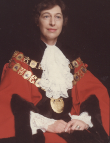
Photograph - Cr Jill O'Brien, Mayor of Kew 1983-84
Born in Bendigo and trained as a nurse in the 1950s, Sonia Jill O’Brien devoted a lifetime to social and environmental issues at both the state and local level. From her work in the 1960s with the Family Planning Association of Victoria, of which she was a founding member, through to the 1990s as a member of the Ethics Committee of the Department of Health, she supported efforts to improve women’s health and reproductive rights. At the local level she was most active on committees that worked to save the natural and built environment. The Power-line Action Group, the Studley Park Conservation Society, and the Yarra Bend Park Trust all benefitted from her indefatigable endeavours as well her vision. In 1980, Jill O’Brien successfully stood for the Kew City Council and served as Mayor in 1983 and 1984. With an eye to preserving the past as well as guarding the future, she had the Mayoral robes restored and in 1980 and 1981 was president of the Kew Historical Society. The preservation and restoration of Villa Alba in Walmer Street owes much to her determined efforts throughout the 1980s. On Council, she chaired a number of committees involved in the saving of the Kew River Parklands from the proposed transmission line of the SEC. To this end, she was the Council representative on the Merri Yarra Municipal Protection Committee.Rare colour photograph, used as the official mayoral portrait of Cr Jill O'Brien.Formal civic portrait of Cr Jill O'Brien in red mayoral robes wearing lace jabot and cuffs. The portrait is part of the larger Jill O'Brien Collection donated by her daughters.cr jill o'brien, city of kew -- mayors, mayoral portraits -- city of kew -
 Kew Historical Society Inc
Photograph - Denmark Street, Kew, 1972
The Engineer's Department of the former City of Kew had an extensive collection of photograph of sites in Kew requiring documentation to inform public works. It also kept images of engineering practice in other parts of Melbourne, and overseas, that could be used as models for local activity. Many of these photographs (and plans) were donated to our collection in the 1980s. A number of the photographs are annotated, either on the image itself or on the reverse.This photograph, and others sourced from the City Engineer's Department of the former City of Kew, qualifies as an important record of local streets, public works, street beautification, and engineering techniques of the period. Original black and white photographic positive of automobiles and buildings in Denmark Street, Kew, immediately before the road enters Kew Junction. On the left is McKeon Motors and a retailer of Insulwool, while in the distance is the pharmacy on the corner of High Street and Princess Street (later demolished during the widening of Kew Junction). Notable are the bluestone guttering and what appears to be vacant land on the apex of the triangle of land bounded by High Street South, Denmark Street and Barkers Road. This site was the original location of O'Shaughnessy's 'Kew Hotel', and after the destruction by fire of the latter, the location of a service station. [It is now the site of the Cresco Reserve].Annotation verso: "Indicating the existence of a vehicular entrance at Denmark St abuttal of No.188 High St prior to reconstruction of channeling &c 1972."denmark street -- kew (vic.), kew junction, luestone gutters, mckeon motors, insulwool -
Kew Historical Society Inc
Book, Australian Council of National Trusts, Historic Houses, 1982
Originally published in 2 separate v.: Historic public buildings of Australia; and, Historic houses of Australia. North Melbourne : Cassell Australia, 1971 and 1974.Canberra City : Australian Council of National Trusts, 1982, c1974 604 p. : ill. (some col.), plans ; 32 cm. non-fictionOriginally published in 2 separate v.: Historic public buildings of Australia; and, Historic houses of Australia. North Melbourne : Cassell Australia, 1971 and 1974.houses of historical importance --australia, historic buildings -- australia. -
 Glen Eira City Council History and Heritage Collection
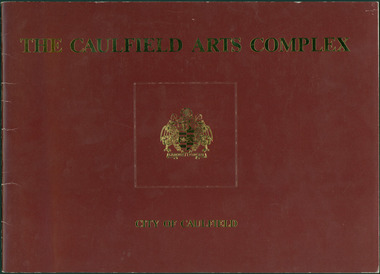
Document - Booklet, "THE CAULFIELD ARTS COMPLEX / CITY OF CAULFIELD", After 1987
Considered to be of historical and social significance. Provides information on the development of the current Town Hall Auditorium and the Glen Eira Gallery.1 x Maroon coloured booklet with gold lettering on cover published by the City of Caulfield. Inside are 14 paper pages with colour concept drawings of the proposed Caulfield Arts Complex, Concept Plans and printed text. Dated May 1987 in the opening page with an Introduction by the Mayor of Caulfield, Cr Jack Campbell. -
 Glen Eira City Council History and Heritage Collection
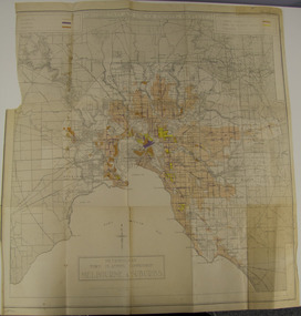
Map - Map, zoning, Metropolitan Town Planning Commission, "DISTRIBUTION AND USE OF EXISTING PROPERTY. MAP NO. 6.", 1929
The map titled: “Distribution and use of Existing property map No. 6” (Metropolitan Town Planning Commission Melbourne and Suburbs) is of historical significance. It is listed on page 168 of Chapter 4 the Zoning section of the "Plan of General Development Melbourne Report of the Metropolitan Town Planning Commission 1929" - Melbourne's first strategic plan. Map No. 6 is mentioned throughout Chapter 4 of the 1929 Report. It states on page 156 that this Map was created to graphically illustrate the data collected by the Planning Commission. The Map illustrates the general distribution of uses of existing property throughout the metropolitan area. The coloured sections show the areas which were developed or were in the process of development in 1929. The colours indicate the distribution of uses in the developed areas. The pink coloured areas, which include Caulfield, were almost completely residential.1929, metropolitan town planning commission, melbourne, suburbs -
Glen Eira City Council History and Heritage Collection
Document (Item) - Newspaper (digital), Caulfield Contact
The Caulfield Contact was the official newspaper of the City of Caulfield from 1976-1994. The City of Caulfield was the Municipal Council for an area of the South Eastern suburbs of Melbourne, including Brighton East, Carnegie, Caulfield, Elsternwick, Gardenvale, Glen Huntly, McKinnon, Murrumbeena, Ormond and St Kilda East. Following Amalgamation of City of Caulfield and parts of the City of Moorabbin in 1994, the Caulfield Contact was followed by the Glen Eira News. Contains References to the following Freedom of Entry to 3rd ordinance of the RAAOC, visit by Sir Zelman Cowen, Return to Rosstown, A 'spacy new home' (nursery at Caulfield Park), Profile on Gus Theobold, Meals on Wheels Aviary completed Caulfield Park. Profile resident Gus Theobold. Cr Irene Capek win Herald Australia Day essay prize. Caulfields Meals on Wheels set Victorian record. Historical feature Return to Rosstown. New ambulance station Glenhuntly and Clarinda roads opens. Volume 4 Number 5 Date 03 August 1978 Features Where and How to Vote in council election. Cr Irene Capek retires from council. Profiles election candidates. Image: Image Cr Irene Capek. Images of election candidates. Volume 5 Number 1 Date 14 September 1978 Freedom of Entry to 3rd ordinance of the RAAOC, visit by Sir Zelman Cowen, Subjects from Carol: GG Sir Zelman Cowen and Lady Cowen offical visit. Off street carpark project underway Pyne St and Hawthorn Rd. City Manager Graeme Caldwell submits plans for Townhall renovations. Action plan for development of Elsternwich Shopping precint to be developed. Freedom of Entry ceremony. Profile Rosemary Keppel. Booran Motors Glenhuntly donate dual control Holden Gemini to Caulfield Tech school pre-driver education program. council election results. Comments from elected Crs Jack Campell, Bob Baxter, Dorothy Ford, Brian Rudzki. Promotion of Caulfield Institute of Technology and TAFE. Image: Image Sir Zelman Cowen, Lady Cowen. Images Freedom of Entry ceremony and citizens attending. Image Rosemary Keppel. Cartoon pre-driver education program. Image Mayor Cr Geoff Patience in robes. Volume 5 Number 2 Date 26 October 1978 Rate rise 5.73% announced. Readership of Caulfield Contact surveyed. Caulfield ranger Reg Dixon and members of works dept rescue duck family from drain and reinstate them to Caulfield Racecourse dam. Profile resident and teacher Claire Manning. Image: Image of Reg Dixon and the rescued ducks. Image Claire Manning and students at Waverley Private school. city of caulfield, caulfield, glen eira, city of glen eira, caulfield contact, freedom of entry to 3rd ordinance of the raaoc, visit by sir zelman cowen, return to rosstown, a 'spacy new home' (nursery at caulfield park), profile on gus theobold, meals on wheels -
Surrey Hills Historical Society Collection
Document - Plans, Andrew Wood, Building plans associated with Andrew Wood, builder of Surrey Hills, 1920s
These plans were associated with Mr Andrew Wood, a contract builder who worked in the 1920s and built many Californian bungalows in Surrey Hills and surrounding suburbs. Andrew Wood was born in Chiltern in 1861 to Andrew and Ellen Wood (MS: Green). His father had emigrated from Falkirk, Scotland. As a young man Andrew worked as a carpenter in the mines in South Africa (c 1899). He married Eleanor Agnes Stuchbery in Hamilton, Victoria in May 1901. They had 5 children - Doris (M Roberts), Robert Andrew, Donald Allen, Jean (M Cowan), and Gwenyth (M Bray). The first 2 children were born in Hawthorn; the other 3 in Surrey Hills. The family home at 286 Canterbury Road, Surrey Hills (on the corner of Middlesex Road) was built by Andrew. Andrew died in 1940; Eleanor died in 1977, aged 100 years. After Eleanor's death the house was sold and demolished. Surrey Lighting was established on the site. Gwenyth May Wood (3 May 1917, Surrey Hills - 5 Jan 2004) married Leslie David Charles Bray (1921-1983). Gwenyth was the donor's mother. Andrew, Eleanor and one son Robert are buried in Box Hill Cemetery - B-071-0028. .1: Specifications & plans for the kinder hall, Howard Street, Mont Albert for the Mont Albert Methodist Church, May 1925 .2 Plans for a proposed villa, 48 Payne's Paddock, Highfield Road, Canterbury for Mr E H Sillifant, dated 22/4/1920 .3 Plans for a timber villa for Mrs J A Burchell at Riversdale Road, Surrey Hills, stamped 9/5/1922 .4 Plan of a garage at Victoria avenue, Canterbury; stamped 14/2/1922 .5 Building permit & receipt from City of Hawthorn re Lot 16 Homebush Crescent; dated 7/4/1925 .6 Plans for a concrete house at Camberwell for Mr H W Field andrew wood, builders, box hill cemetery, kindergartens, mont albert methodist church, building plans, highfield road, ernest horatio sillifant, victoria avenue canterbury, lot 16 homebush crescent, californian bungalows, h w field -
 Brimbank City Council Art Collection
Photograph, Robert Pointon, Huntsman chemical plan in distance, 1989
Local SceneHuntsman Chemical Plant in distance. Quarry now a tip to the right. Taken in South Sunshine near Kororoit Creek - AR0036 -
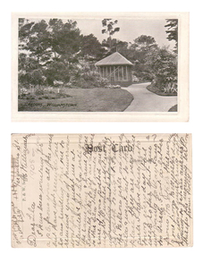 Williamstown Botanic Gardens- Hobsons Bay City Council
Postcard – Williamstown Botanic Gardens, c1900-1920
The original postcards in this series (2013.002 to 2013.018) were generously loaned to Williamstown Botanic Gardens by a private collector for copying. The postcards are evidence of the interest the gardens held as a subject for postcard publishers. The text and images provide a snapshot into fashions, social interests and concerns of the time. The professionally produced images provide a pictorial history of Gardens including changing planting styles, various structures and features of the Gardens eg the aviary, cannons, the fountain, the second Curator’s Lodge and gates. The images offer an opportunity to compare garden vistas with the present day. This card is a rare image of the original aviary built in the Gardens in 1892. The card also demonstrates how postcards were used as a method of contact in contrast to the contemporary use as souvenirs. The writer of the card, Polly, is anxious to receive a return postcard from Lila, writing that a reply should be sent that night. A black and white scene of a curving path with a square looking building at the centre. The 1894 MMBW plan shows that the building was triangular. The building is solid at ground level with the appearance of long vertical columns. The roof is light coloured and hip shaped with a finial at the apex. There is a garden set in the lawn on the left side of the image, shrubs and a palm at the left front corner of the building and tall trees in the background. The building is an aviary, which was built in north east section of the Gardens during 1892. The date of its removal is unknown. Front: ‘GARDENS, WILLIAMSTOWN’. Reverse: Centre top: ‘Post Card’; Vertical on left side: ‘P. & W. Series’; Right side ‘Address Only’. The card is addressed to Lila of ‘Ferguson St, N Williamstown’ from Polly. In pencil ‘1908 or later’ (believed to be inserted by the vendor of the card).postcard, gardens, post-card, williamstown-botanic-gardens, hobsons-bay-city-council, garden-path, aviary, 1908