Showing 110058 items matching "roads"
-
 Whitehorse Historical Society Inc.
Article, Biography notes City Designers Skills, 1991
Anne Latrielle's new Biography of noted Melbourne Landscape Gardener, the late Ellis Stones,Anne Latrielle's new Biography of noted Melbourne Landscape Gardener, the late Ellis Stones, entitled 'The Natural Garden', contains some fascinating snippets about Nunawading. He had 'innovative' ideas on planting median strips along Springvale and Canterbury Roads.Anne Latrielle's new Biography of noted Melbourne Landscape Gardener, the late Ellis Stones,landscapes, stones, ellis, blackburn and district tree preservation society, latreille anne - the natural garden -
 Surrey Hills Historical Society Collection
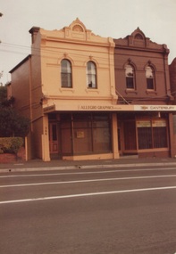
Photograph, 386-384 Canterbury Road Surrey Hills
The donor, Bob Lennox believed that these were the work of his great-grandfather William Lennox and his builders. William and his son were plasterers and often used the shell motif which is seen on the pediment of the buildings. These two terraces were part of the retail development of five terraces along Canterbury Road which were constructed on land subdivided from the parcel of land originally owned by John Woodhead. The Alan Holt register of properties in 3127 gives a list of proprietors / residents at the beginning of each decade from 1890-1980. There are also earlier photos depicting these buildings in the collection. These buildings have been included in the City of Boroondara Heritage Overlay Union Road Commercial Precinct 2011, Surrey Hills.These buildings were amongst the first commercial buildings serving the area of Surrey Hills and followed the extension of the railway from Camberwell in 1883.A colour photo with rounded corners taken from slightly diagonally across Canterbury Road from 2 double-storey Victorian style buildings. Both have the decorative shell motif in the pediment.Back of photo in green pencil "CANTERBURY RD SURREY HILLS / EAST OF UNION RD"victorian style, allegro graphics, william lennox, 386-384 canterbury road, shops, victorian terraces, canterbury road, surrey hills, john woodhead, heritage overlay union road commercial precinct 2011, heritage overlays -
 Surrey Hills Historical Society Collection
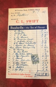
Document - Account, C. L. Swift order docket re Mrs Matthews. 21/8/1957
Clive Leslie Swift (RAAF 430415) was born in Elsternwick in 1924 and served in the RAAF in Borneo during WW2. He was mentioned in dispatches. He married Enid (Ina) Mary Smith in 1947. Together they ran the grocery store at 10 Croydon Road from 1949 until some time after 1954. In the 1980s they were living in Highbury Road, East Burwood and Clive was working for Unigate (later Bonlac) in a managerial position. (REF: Oral testimony, Libby Wilson, Canterbury History Group). The shop continued after the Swifts left but was later destroyed by fire. Clive Swift died in March 2014. This and other dockets were tucked into Ruth Matthews' recipe folder. Ruth and Harold Geoffrey (Geoff) Matthews lived at 42 Guildford Road, Surrey Hills. The donor recalled that her paternal grandmother (Ethel May Matthews) also occasionally shopped at the Swifts' shop as it was closer to her home (31 Guildford Road) than either than Griffith’s on Union Road or Thomas’ on Maling Road . Dockets such as these are reflective of shopping in the pre-supermarket era when women generally walked to the local shop or had proprietors or a staff member come to the house to take weekly orders. A pre-printed grocery docket for C. L. Swift (Late R.A.A.F.) on cream (slightly discoloured) paper printed in black, red and blue filled in with 19 hand-written items, their prices and the total of the grocery order. A green and cream duty stamp to the value of 3d is attached and over-signed with initials as having been paid. Order was for Mrs Matthews of Guildford Road.clive leslie swift, miss enid (ina) mary smith, mrs enid (ina) mary swift, croydon road, guildford road, grocery store, docket, accounts, bushells tea, mrs ruth matthews, harold geoffrey matthews, 'geoff' matthews -
 Surrey Hills Historical Society Collection
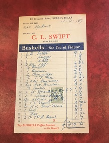
Document - Account, C. L. Swift order docket re Mrs Matthews. 21/8/1957
Clive Leslie Swift (RAAF 430415) was born in Elsternwick in 1924 and served in the RAAF in Borneo during WW2. He was mentioned in dispatches. He married Enid (Ina) Mary Smith in 1947. Together they ran the grocery store at 10 Croydon Road from 1949 until some time after 1954. In the 1980s they were living in Highbury Road, East Burwood and Clive was working for Unigate (later Bonlac) in a managerial position. (REF: Oral testimony, Libby Wilson, Canterbury History Group). The shop continued after the Swifts left but was later destroyed by fire. Clive Swift died in March 2014. This and other dockets were tucked into Ruth Matthews' recipe folder. Ruth and Harold Geoffrey (Geoff) Matthews lived at 42 Guildford Road, Surrey Hills. The donor recalled that her paternal grandmother (Ethel May Matthews) also occasionally shopped at the Swifts' shop as it was closer to her home (31 Guildford Road) than either than Griffith’s on Union Road or Thomas’ on Maling Road . Dockets such as these are reflective of shopping in the pre-supermarket era when women generally walked to the local shop or had proprietors or a staff member come to the house to take weekly orders. A pre-printed grocery docket for C. L. Swift (Late R.A.A.F.) on cream (slightly discoloured) paper printed in black, red and blue filled in with 19 hand-written items, their prices and the total of the grocery order. A green and cream duty stamp to the value of 3d is attached and over-signed with initials as having been paid. Order was for Mrs Matthews of Guildford Road.clive leslie swift, miss enid (ina) mary smith, mrs enid (ina) mary swift, croydon road, guildford road, grocery store, docket, accounts, bushells tea, mrs ruth matthews, harold geoffrey matthews, 'geoff' matthews -
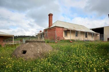
 Melton City Libraries
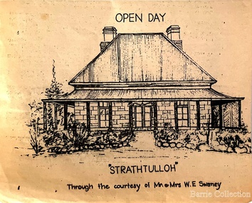
Drawing, Open Day at Strathtulloh, Unknown
"Strathtulloh, 1402-1600 Greigs Road, Melton South, is significant as an early property in Victoria, retaining different eras of pioneering dwellings, ranging from a ruin to a fine Colonial style homestead. The property has close historical association with the early settlement of the Melton district, and was owned by the Henty family in the 1840s. The Strathtulloh property was alienated by the Crown in 1840 to Charles James Garrard, who sold it in 1848 to Charles and Stephen Henty, whose sister Jane and her husband Samuel Bryan lived there in the late 1840s. In 1853 the property then passed to William Tulloh, after whom the homestead was named. A primitive bluestone ruin of near the Toolern Creek, built of vesicular bluestone and mud mortar, is of unknown origin. It has commonly been assumed to pre-date 1840, and to have belonged to the original holder of the Exford lease, Dr Watton or Port Phillip Association member Dr Cotterill. This is unlikely, as the 1841 census records Dr Watton, and everyone else in the district, as living in a ‘wood’ dwelling. It may instead have been the residence of Garrard, and the Bryans, in the 1840s and an early map names a site near here as ‘Bryan’s outstation’. It is assumed that the two-level stone building that became the kitchen is the earliest intact building on the site, and was the first homestead; it is likely to date to the 1840s or 1850s. The main homestead is a substantial villa constructed of random coursed bluestone, with a verandah facing three sides, attic bedrooms with dormer windows, a fan light over the front door, a hipped roof originally clad in slate, and a large cellar. Although demonstrating characteristics of pioneering construction, such as unworked log beams, pit sawn beams, hand-sawn lintels and colonial door locks, documentary evidence shows that it was built c.1869. The homestead has now been structurally repaired and decoratively restored; a sympathetic new semi-detached rear extension was added in the early years of the 21st century. The former kitchen building has also undergone minor repairs and alterations". Strathtulloh Homestead at 1402-1600 Greigs Road, Melton Southlocal architecture -
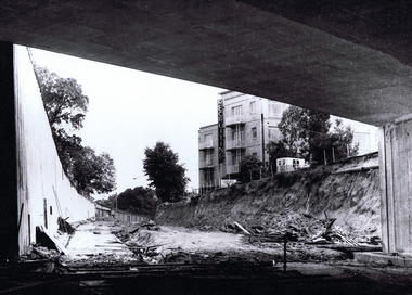 St Kilda Historical Society
Photograph, St Kilda Juncton Construction Queens Rd underpass, c. 1967
hand written on back: Queen's Road underpass. Photo filed 11.12.1967 Shows a building with a large vertical neon sign 'Recruiting'black and white matt photograph good condition unmountedQueen's Road underpass. Photo filed 11.12.1967 L16514/5 H71. Copyright. This photograph may not be reproduced without permission in writing from the Editor of "The Age". 250 Spencer Street, Melbourne and 39/41 York st, Sydney. -
 Kiewa Valley Historical Society
Photographs – Bogong High Plains - Set of 16 black and white photographs mounted back and front on 3 pieces of heavy black card likely removed from a photograph album
After World War II, the Kiewa Hydro-Electric Scheme was started in the Kiewa River Valley by the State Electricity Commission of Victoria. On land previously used only for summer cattle grazing in the natural alpine grasslands, the first ski lodge was built in 1948 by workers from the hydro scheme as skiing was a popular recreation. Many of the hydro employees were of European background and had grown up enjoying skiing and snow sports in their homelands and were keen to continue to pursue their winter sports interests. The first lift, a rope tow, was built at Falls Creek in 1951 and the first chairlift in Australia was constructed there in 1957. Two T-Bars were opened in 1961. In 1964, the Victorian Municipal Directory recorded that Falls Creek had 29 ski club lodges and 16 commercial lodges. The area became a popular tourist destination for both winter and summer sports.Employees of the State Electricity Commission of Victoria in the Kiewa River Valley were the earliest skiers on the Bogong High Plains and built one of the first ski lodges at Falls Creek. They were amongst those pivotal in the development of the skiing and tourist industry at Falls Creek and on the Bogong High Plains. Black and white photographs of varying sizes mounted decoratively on heavy black Card. Some pages display a brief description printed in white ink 1. 4 photographs- displayed diagonally across page. 2 pictures of a group of men standing in the snow in front of a car with a loaded trailer behind. 1 photo of skiers. 1 photo of show hanging in tree branches. 2. 2 photographs- showing Upper Kiewa Road with snow in the background 3. 3 photographs- of skiers and 1 photo of 2 of men posing in the snow & 1 photo of 2 men posing shirtless in warmer weather. 4. 2 photographs- arranged diagonally on page showing early buildings and construction at Bogong Village 5. 2 photographs- 1 showing view of Bogong Village from higher up the mountain. 1 showing early Bogong High Plains road 6. 1 photograph- showing view down along Kiewa Valley from higher up in the mountains 1. Handwritten in white ink – A TRIP TO THE PLAINS 2. Handwritten in white ink – UPPER KIEWA ROAD MT FAINTER IN BACKGROUND 3 – 6. No markings bogong village; upper kiewa road; bogong high plains; falls creek; skiers -
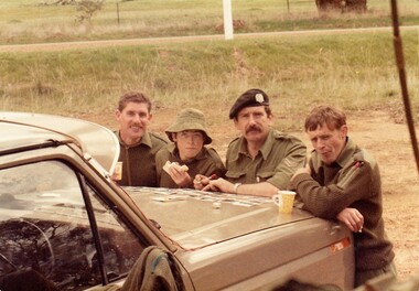 8th/13th Victorian Mounted Rifles Regimental Collection
Photograph - Sandwich and tea
While many recruits could already drive when they joined 8/13 Victorian Mounted Rifles it took many hours of instruction and training before they were licenced to drive heavier, more complex army vehicles both on and off road and under combat conditions.Members of the Women’s Royal Australian Army Corps (WRAAC) were posted to Army Reserve units in the 1980s and 1990s. They were rarely posted to Armoured Fighting Vehicles (AFVs) but were invaluable in the A1 Echelon driving fuel, ammunition, ration and water supply vehicles. Shows citizen soldiers on weekend training.Colour photograph of 4 soldiers of ' A ' Squadron 8/13 Victorian Mounted Rifles at a road side break during a driving exercise, 1986. From left : Corporal M. Roberts, Private T. Roche, Corporal Tewson and Trooper Bowerman.military, citizen soldiers, vmr, uniform -
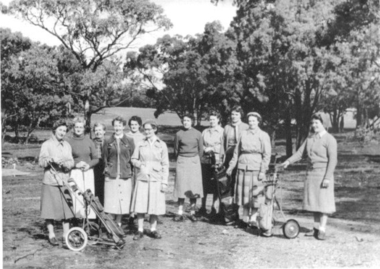 Clunes Museum
Photograph, C1950'S
CLUNES GOLF CLUB LADIES PLAYERS. Late 1950's at the old Clunes Golf Course in Keirces Road.CLUNES GOLF CLUB LADIES PLAYERS - B. FENTON, M. HARVEY, J. McDONALD, D. VORBACK, Nance Mead, Phyllis PICKFORD, Ida LEISHMAN, Mavis Williams, Allison Coutts, Ivy Loader , E. TOOLE. Late 1950's at the old Clunes Golf Course in Keirces Road.photograph, golf, clunes golf club -
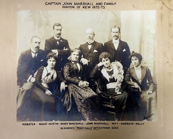 Kew Historical Society Inc
Photograph - Family Portrait, Captain John Marshall and Family, Mayor of Kew 1872-73, 1890s
Captain John Marshall was born in Dundee, Scotland c.1833. Within eleven years of his arrival in Melbourne in 1852, he had established an important colonial shipping company, Anderson & Marshall, and married Mary Austin, the eldest daughter of Thomas Austin Esq of Clifton Villa in Cotham Road. Elected to the Kew Borough Council in 1869, he remained an active member until 1875. During this period, he was elected Mayor of Kew in 1872. A Scottish Protestant by birth and conviction, John Marshall was, with David Beath, a member of the inaugural committee that began planning for a separate Presbyterian Church in Kew, lending the Committee the funds to purchase land on the corner of Cotham Road and Highbury Grove. John Marshall lived at his home, 'Maryfield', at what was then 239 [now 197] Cotham Road until shortly before his death at the age of 70 in January 1903. He was buried on 14 January in Grave 493, Presbyterian Compartment A, Boroondara General Cemetery.Family portrait of an important civic figure in Kew in the 19th century who was also a notable businessman and shipowner in the Colony of Victoria.Albumen Silver photograph on card of Captain John Marshall and family, Mayor of Kew 1872-73.The inscription was added by the family and at one stage modified. In addition to the title, the sitters' names are inscribed beneath the photograph on the mountCaptain John Marshall and family / Mayor of Kew 1872-73 Webster - Maud - Austin - Mary Marshall - John Marshall - May - Andrew - Polly / Residence “Maryvale” 197 Cotham Road. john marshall, maryvale (cotham road, kew), maryfield (cotham road, kew), webster marshall, maud marshall, austin marshall, mary marshall, may marshall, andrew marshall, polly marshall -
 Kew Historical Society Inc
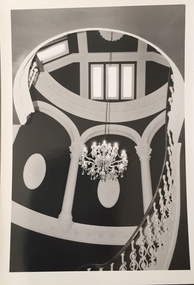
Photograph - 'Butleigh Wooton', 867 Glenferrie Road, John T Collins, 1979
in 1882 Thomas Maidment paid the Society of Jesus £5,750 for nine allotments along Barkly Road (now Glenferrie Road). Maidment, who had arrived in Australia from the Glastonbury district in England in 1858, owned and managed a number of sheep stations in Victoria and subsequently became an '... eminently respectable ...' member of District society. In 1883 the Rate Books list Maidment's land in Barkly Road as the 'Buxton Hill Estate' and it was given an N.A.V. of £90, while in the following year his property attracted an N.A.V. of £160, suggesting that substantial improvements were taking place. Maidment's two-storey mansion, named 'Butleigh Wooton' after his birth-place in England, was completed in 1885 and was given an initial N.A.V. of £420. While Maidrnent is recorded as the owner of the building until at least 1896, Jane Maidment, his wife, continued the family ownership of the twenty-six roomed house with its extensive grounds until at least 1910. (Sanderson P. City of Kew Urban Conservation Study Vol 2)Butleigh Wooton is a substantial two storeyed house built in the Italianate style common in the 1880s. Its walls are rendered and it has limited applied decoration that includes brackets to the eaves line and engaged ionic columns under a broken pediment over the front entrance. The bowed window unit is of particular distinction and is not at all typical of this type of building. This interior by John T Collins is a view of the staircase from the first floor landing. (Sanderson P. City of Kew Urban Conservation Study Vol 2)Reverse: "JOHN COLLINS / 11 Anderson Road / Hawthorn East, 3123 / Film 395 Exposure 21A / Kew / Butleigh Wooton / Staircase looking up to dome / 8-4-79thomas maidment, butleigh wooton, 867 glenferrie road -- kew (vic.), john t collins -
 Ballarat Tramway Museum
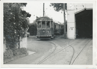
Photograph - Digital image, Wal Jack, 23/11/1963 12:00:00 AM
Yields information about the appearance of the tram depot and storage of trams on 0 road.Digital image from the Wal Jack Ballarat Album of photographs of No. 38 and 43 parked on the Ballarat depot "0" road, 23-11-1963. Wal Jack photo. See image i2 for rear of photograph. See image i3 for hi res scan of print. See image i4 for hi res scan of negative on rear in black in "SEC Ballarat bogies 38 and 43 on "0" road Wendouree depot 23-11-63" with Wal Jack stamp in top right hand corner with number "T1278" written in.trams, tramways, depot, tram 43, tram 38 -
 Ringwood and District Historical Society
Photograph, Barkly St, Ringwood. Shop of Dark's, corner Haig St (undated)
Rough dirt Road.Written on backing sheet, "Barkly St. Shop of Dark's, corner Haig St." -
Whitehorse Historical Society Inc.
Book, Wandering Whitehorse Road, 2014
A history of Whitehorse Road.A history of Whitehorse Road.A history of Whitehorse Road.whitehorse road, history -
 Ringwood and District Historical Society
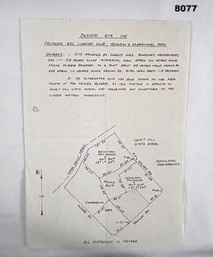
Document - Subdivision Plan, LP10477 Parish of Warrandyte, County of Evelyn, Vol 2453 Fol 574 - 1924
LANDATA Land Victoria plan printout circa 2010Part of Crown Allotment 30. Map includes Warrandyte Road, Kennedy Avenue and Wonga Road, Ringwood. Street name amended from Wonga Road to Loughnan Road 1940. Other markings include CP102182, CP171386, LP127934, PS349846, RP7582, PS309312,RP8679 and CP106336. -
 Bendigo Military Museum
Plan - PROPOSED BDSC SITE, Bendigo RSL Sub Branch, C.1977
The plan relates to the proposed Bendigo & District Servicemen's Club in Havilah Road. The slightly shaded area is the site. This plan was put to a General Members meeting in September 1976. The club received its Liquor License in 1979. Refer Cat No 8073P for more details. This item was in the collection re David Patterson, refer Cat No 8070.Plan and details on A4 sheet, all text and sketch in black, top has site desired with 2 sets of remarks underneath, at bottom sketch of possible site on Havilah Road Bendigo."Desired site for proposed RSL Licenced Club, Memorial and recreational park"brsl, smirsl, bdsc, plan -
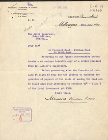 Whitehorse Historical Society Inc.
Letter - Correspondence, Mitcham Road, 1932
Correspondence between Shire Secretary, Shire of Blackburn and Mitcham and vendors and their solicitors re transfer of land for a road between Mitcham Road and Creek Road, Mitcham, June - July 1932.mitcham road, mitcham, creek road, mitcham, shire of blackburn and mitcham, maddocks, jamieson & lonie, solicitors, ashley (mr), bloom, f.a., roads and streets -
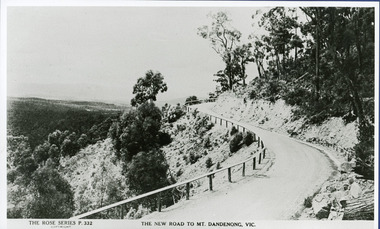 Mt Dandenong & District Historical Society Inc.
Photograph, The New Road to Mt. Dandenong Vic. c1935, c1935
Rose Series Postcard number 332c1935. Enlarged for display from Rose postcard 'New Road' (Mt. Dandenong Tourist Road). Completed by 1930 but no bitumen as yet. Road not wider and rail along outer edge.kalorama, rose series, mt. dandenong tourist road -
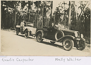 Lakes Entrance Historical Society
Photograph, Carpenter Family Lakes Entrance Victoria, 1929 c
Nally about to tow Charlies ute on bush road near Lakes Entrance Victoria - also named in one photograph is John Hindle Black and white photograph of Charlie Carpenter and Nally Whiter each in single seater utility style vehicle, Nally about to tow Charlies ute on bush road near Lakes Entrance Victoria. Also eight black and white photographs of Charlie and Keith Carpenter at various ages,genealogy, fashion -
Tatura Irrigation & Wartime Camps Museum
Photograph - Framed Photograph, Atherston Homestead
Photo of home built by John Donaldson around 1890. Atherston Homestead. Tatura homestead. John Donaldson. A Bountiful Harvest. Allen Staley Donaldson. Homestead with Garden. Harston. Heath Road. Black and white photo in silver coloured frame of front and side of house with veranda and front garden. Child on stepsHand written on border Atherston Homestead, 310 Heath road, Harsten, Tatura, around 1890. Built by John Donaldson. Ref a Bountiful Harvest - page 150. Allan Stanley Donaldson - child on steps. house, garden, child -
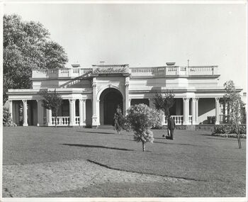 Kew Historical Society Inc
Photograph - 'Southesk', Cotham Road, c. 1965
Ordsall (c.1864-1970) - Situated on the southwest corner of Cotham Road and Charles Street, the single-storey Italianate mansion, Ordsall, was built for John Halfey in the 1860s. Following extensions in 1878 and 1881to designs by Michael Hennessy, Halfey commissioned the decorating firm of Cullis Hill & Co to create elaborate coloured frescoes on the ceilings of the drawingroom and ballroom in 1882. These frescoes were among the finest created in Melbourne during this period. Sold in 1905 to David Carnegie, and renamed South Esk, it was sold to the City of Kew in 1947 and demolished in 1970.This work forms part of the collection assembled by the historian Dorothy Rogers, that was donated to the Kew Historical Society by her son John Rogers in 2015. The manuscripts, photographs, maps, and documents were sourced by her from both family and local collections or produced as references for her print publications. Many were directly used by Rogers in writing ‘Lovely Old Homes of Kew’ (1961) and 'A History of Kew' (1973), or the numerous articles on local history that she produced for suburban newspapers. Most of the photographs in the collection include detailed annotations in her hand. The Rogers Collection provides a comprehensive insight into the working habits of a historian in the 1960s and 1970s. Together it forms the largest privately-donated collection within the archives of the Kew Historical Society.The front garden and facade of South Esk in Cotham Road, Kew, during the period when it was owned by the City of Kew. The mansion was demolished by the City in 1970."2. Chap 22 Southesk . Ordsall John Halfey. Orig. part to 1858. Additional about 1862. Southesk once Ordsall . Demolished to make way for Municipal Chambers. Commenced approx. 1858 added front by John Halfey 1862."south esk, ordsall, david carnegie, kew city council, cotham road (kew), dorothy rogers, john halfey -
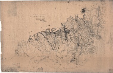 Ringwood and District Historical Society
Map, Survey of Dividing Range between Yarra Yarra and Western Port - William Wedge Darke, 1843
Extract - Ringwood, Place of Many Eagles - Hugh Anderson (1974): William Wedge Darke, from Hereford, England, was a nephew of John Helder Wedge of the Port Phillip Association, who was also a surveyor. William's most important work was probably his survey of the Dividing Range and the country between the Yarra River and Western Port, completed in May 1843, and during which he made a traverse between the Mullum and Dandenong creeks along the higher ground that he labelled the "best line of road from Melbourne". This road was for many years the major route to Gippsland and to the higher country about Alexandra and Mansfield, sometimes known as White Horse Road, and now Maroondah Highway.Surveyor's relief map of features to the east of Melbourne including Yarra Yarra River, Mullum Mullum Creek, Anderson's Creek, Dandenong Creek.Transmitted to the Surveyor General with my letter of 10th May 1843 (signed) Wm Wedge Drake, Assistant Surveyor. Scale: two inches to a mile. Descriptive remarks include upstream area of Yarra River - "impassable, appears to have been formerly a lake", and to the south - "barren and scrubby swamps of the Western Port Country". Marked tracks include "best line of road from Melbourne", "track to Dandenong", "Road to Port Albert may probably be found on this range", "Best line to Upper Yarra". Several huts also marked. -
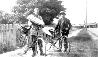 Surrey Hills Historical Society Collection
Photograph, Mr Joyce and Mr Lamble of Essex Road, Surrey Hills, c 1932, 1932
Date is approximate - early 1930s. Mr Oswald Joyce and Mr Bert Lamble used to ride their bicycles to the country to find work when they became unemployed. This included reworking old gold mines. Here they are seen leaving for Enoch's Point where they fossicked for gold during the Depression. A check of the electoral rolls points to this being the home of Frederick Harry Percival Lamble, labourer, born in Collingwood. He and his family continued to live at 87 Essex Road until his death in 1968 and his occupation is consistently given as labourer. His wife Bessie Louisa Woods died in 1957.Black and white photo of 2 men identified, but not specifically, as Mr Joyce and Mr Lamble, both of Essex Road, Surrey Hills. They are standing next to their bicycles on a roughly made path. The bikes are loaded up with swags and kit as if the two are about to depart on a journey. Behind is a picket fence and in the background the shops along Canterbury Road can be seen.essex road, frederick harry percival (mr), bicycles, depression, 1929-1939, unemployment, economic depression, mr joyce, bert lamble, frederick harry percival lamble, bessie ethel lamble, bessie ethel smith -
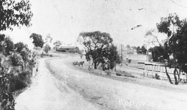 Ringwood and District Historical Society
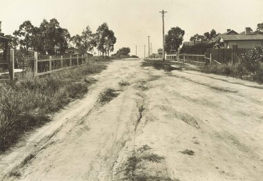
Photograph, Maroondah Highway Central, Ringwood. Main Street, c1909
Photograph (2 copies- 1 large black and white, 1 small sepia)Written on photograph: "Ringwood, Vic." Image shows view of dirt road looking west from Warrandyte Road with shops on right, and Station Masters house in background. Horse and dray in middle of road. -
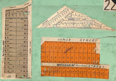 Ringwood and District Historical Society
Card, Subdivision Maps - Ringwood, Victoria - (Undated, circa 1920s)
Collage of three residential allotment maps on green cardboard backing.Subdivisions include West Prussia Road, Wantirna Road, Station Street, James Street, Bedford Road, Williams Grove (later Lena Grove), and William Street (later Kendall Street), Ringwood. -
 City of Whittlesea
Photograph (item) - Photographs - Buildings, Hin Lim Photography, Blackbraes Farm, 21/6/2017
Blackbraes Farm is listed in the Whittlesea Heritage Overlay HO14, Photographic survey, 10 Cravens Road Merndablackbraes farm, mernda -
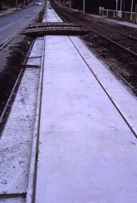 Melbourne Tram Museum
Slide - Set of 2, Keith Kings, 23/03/1968 12:00:00 AM
35mm Kodak white cardboard colour slide by Keith Kings of 23/3/68 and 6/4/68. .1 - Glenferrie Road Kooyong track renewal showing the first section of completed track. Shows two road crossovers. .2 - ditto, showing one end of the new crossover with temporary track on the right. See Keith's slide notes.Keith Kings stamp and number "20-19" and "20-32", with details of exposure. 23/3/68 and 6/4/68. .1 - "New concrete trackwork in Glenferrie Rd north from Kooyong railway Xing ready to be brought into use. Temporary track still in use at right" .2 - "New design for xover in Glenferrie Rd, near cnr Gardiner Rd Kooyong, Removable sections form the road surface and facilitate maintenance and renewal."trams, tramways, glenferrie road, trackwork, temporary track, kooyong -
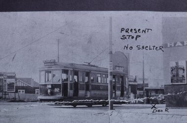 Melbourne Tram Museum
Slide - Black and white reproduction photograph - K class tram 92, mid 1920s
Photograph - of a K class four-wheel or single truck tram on a PMTT route 14 (STRATHALBYN ST (Kew) - VICTORIA BRIDGE) tram service, at Harp Road and High St. The reference gives the tram based at Kew Depot in 1928. The tram was originally a Prahran and Malvern Tramways Trust tram, though, by the time of this photograph, it has been re-lettered for the MMTB, which took over the PMTT in 1920. The photograph has been marked up for a submission possibly to either Council or the MMTB for a waiting room or shelter at this location. The wall of the Harp of Erin Hotel and a Victoria Bitter sign can be seen on the right-hand side. The original photo appears to have been torn. Original photo mid to late 1920's.Yields information about the K class tram of the MMTB and methods of seeking a tram stop shelter and High Street and Harp Road intersection.Kodachrome cardboard duplicate slide - Black and white reproduction photograph - K class tram 92 - at Harp Road Kew "MP17" in penciltrams, tramways, kew, harp road, route 14, k class tram, tram 92, harp of erin, victoria bitter, high st, strathalbyn st -
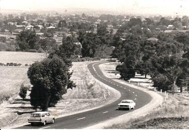 Hume City Civic Collection
Photograph, Early 1970s
In the early 1970s the eastern approach to Sunbury was changed. The stone bridge spanning the Jacksons Creek was replaced by a wider concrete structure and dangerous curves were taken out of the road. The area on the LHS of the photograph including the two arched stone bridge has been incorporated into a public picnic area.A black and white panoramic view of the eastern approach to Sunbury and the Sunbury township before the road was widened and straightened and the new bridge was built. There are two cars in the foreground. One is approaching the bridge and the other is leaving Sunbury.macedon street, macedon street road bridge, jacksons creek, sunbury township, george evans collection -
 Eltham District Historical Society Inc
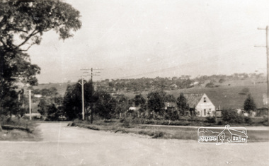
Photograph, Main Road, Lower Plenty
Black and white photograph of Main Road, Lower Plenty looking west from Old Eltham Roadlower plenty, main road, old eltham road