Showing 28492 items
matching street street
-
 Ringwood and District Historical Society
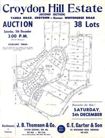
Flyer, Land Auction Sale Advertisement, Croydon Hill Estate, Croydon, Victoria - 1959
... , Whitehorse Road, Alice Street, Hull Street (later Mulawa Stret... Richardson Road, Yarra Road, Whitehorse Road, Alice Street, Hull ...Single sided land auction sale advertisement for 38 residential allotments - Croydon Hill Estate (Second Section) Yarra Road, Croydon - corner Whitehorse Road. Auction Saturday, 5th December, and corresponding newspaper advertisement - Ringwood Mail, Thursday, November 26, 1959.Subdivision map includes Richardson Road, Yarra Road, Whitehorse Road, Alice Street, Hull Street (later Mulawa Stret). Auctioneers in Conjunction: J.B. Thomson & Co., Station Entrance, Box Hill, (Telephone) WX 1862, WX 7356, and at Nunawading, WU 1968, WU 3452, and C.E. Carter & Son, 126 Whitehorse Road, Ringwood. WU 6024. -
 City of Ballarat Libraries
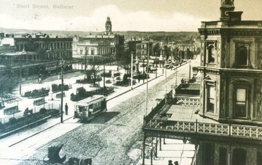
Postcard - Card Box Photographs, Postcard of Sturt Street, Ballarat circa 1905
... Postcard of Sturt Street, Ballarat circa 1905....sturt street...North east view of Sturt Street from Doveton Street North...City of Ballarat Libraries Eureka Centre Eureka Street ...North east view of Sturt Street from Doveton Street North. You can see both electric trams and horse drawn cabs. Verandas with decorative balustrades. In the garden in the middle of the street are seats with sun shades.sturt street, postcard, streetscape, garden, building, commerical, vehicle -
 Greensborough Historical Society
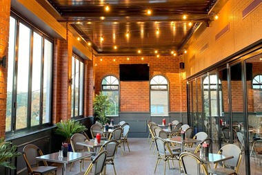
Photograph - Photograph - Digital Image, Marilyn Smith, Greensborough Hotel Alfresco Beer Garden 2019, 23/08/2019
... main street greensborough...The Greensborough Hotel is on the corner of Main Street...The Greensborough Hotel is on the corner of Main Street ...The Greensborough Hotel is on the corner of Main Street and Hailes Street Greensborough. Built in the early 1920s, the hotel has been refurbished and extended over the years. In 2019 the alfresco area / beer garden was renovated and these photographs show the result.2 colour digital photographsgreensborough hotel, main street greensborough, beer garden, alfresco dining -
 Greensborough Historical Society
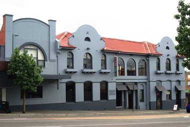
Photograph - Photograph - Digital Image, Marilyn Smith, Greensborough Hotel 2018, 18/06/2018
... main street greensborough...The Greensborough Hotel is on the corner of Main Street...The Greensborough Hotel is on the corner of Main Street ...The Greensborough Hotel is on the corner of Main Street and Hailes Street Greensborough. Built in the early 1920s, the hotel has been refurbished and extended over the years. In 2018 the exterior of the hotel was painted grey as in this photo. Previously it was painted green.The Greensborough Hotel remains a landmark in the changing face of Greensborough.Colour digital photographgreensborough hotel, main street greensborough -
 Bendigo Historical Society Inc.
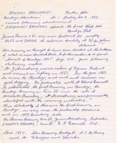
Document - NOTES RE: VARIOUS BENDIGO BUILDINGS
... to: Sandhurst Brewery (Havelock Street); Bendigo Brewery (Vine Street... Inc. History House 11 Mackenzie Street Bendigo goldfields ...Handwritten 'Notes' re various Bendigo buildings (no author, no date) - for a talk or article? References to: Sandhurst Brewery (Havelock Street); Bendigo Brewery (Vine Street); Mr J Armstrong; Phoenix Brewery (Vine Street); Star Brewery (Bridge Street); Shamrock Hotel; Phillip Kennedy; Vahland and Getschmann; Royal Theatre; Haymarket Theatre; Scherffs Store; Abbotts Hotel and Assembly Room; Lyceum Theatre; G A Fletcher; Moore Bros Store; Lyric Theatre; H Barrow; Campaspe Inn (Runnymede)buildings, commercial, breweries -
 Bendigo Historical Society Inc.
Map - FORTUNA HUSTLER'S MINE - PLAN OF FORTUNA HUSTLER'S MINE
... a number of the streets. Carpenter Street is called Cemetery Road... Inc. History House 11 Mackenzie Street Bendigo goldfields MAP ...Map and plan of the Fortuna Hustler's Mine on the Hustler's Line of Reefs. Bulletin No 33, Plate No 1. Plan gives depth of the different levels. Bendigo Railway Station is on the map and also a number of the streets. Carpenter Street is called Cemetery Road. Also on the Hustler's Line of Reef is the Summer Hill Shaft. Shown is the Hustler's Royal Reserve No 2 Lease. Map has the Geological Survey of Victoria crest. It is signed by H Whit ?an Underground Survey Office Bendigo, September 1913. This item has not been scanned or photographed.map, fortuna hustler's mine, plan of fortuna hustler's mine, hustler's royal reserve no 2 lease, summer hill shaft, hustler's line of reef -
Kew Historical Society Inc
Plan - Tramway Estate, Camberwell North, 1937
... by Doncaster Road, Burke Road, Marwan Avenue, Maud Street, Severn... by Doncaster Road, Burke Road, Marwan Avenue, Maud Street, Severn ...Subdivision plans and real estate flyers/brochures reveal a number of aspects of urban development and history. The Kew Historical Society's collection of these plans, as well as advertisements extracted from magazines, cover key aspects of community development and architectural history of Kew and Kew Eat as well as surrounding suburbs. While most of the plans in the collection were gifted to the Society by the former City of Kew, a number of other plans and advertisements have been donated by individuals, of which this is an example.Single page subdivision plan listing properties for sale in the Tramways Estate, Camberwell North. The large estate was bounded by Doncaster Road, Burke Road, Marwan Avenue, Maud Street, Severn Street, and extended over Glass's Creek at Mayland's Avenue. Within the plan, lots 3 to 342 are listed as lots. The plan includes annotations in ink indicating the prices realised by a number of lots. A key explains that lots with an 'H' represent a house, whereas the 37 shaded lots represent those being offered by this agent. subdivision plans -- camberwell (vic.), tramways estate -
 Eltham District Historical Society Inc
Photograph, Russell Yeoman, Frosty morning, 66 Susan Street, Eltham, c.1965, 1965c
... Frosty morning, 66 Susan Street, Eltham, c.1965...susan street...Now the site of the Eltham Skate Park; Susan Street north...Susan Street, Eltham, Victoria, Australia... melbourne Now the site of the Eltham Skate Park; Susan Street north ...Now the site of the Eltham Skate Park; Susan Street north of Bridge Street has since been renamed as an extension of Brisbane Street.Digital file only; created from original colour positive slide transparencyeltham, streets, susan street, eltham skate park, russell yeoman collection -
 Ringwood and District Historical Society
Photograph, Ringwood Oval, Ringwood Street - circa 1918, 1918
... Ringwood Oval, Ringwood Street - circa 1918... Street and Charter Street in the centre backgroun.. The school... Street and Charter Street in the centre backgroun.. The school ...Ringwood Oval circa 1920, showing Ringwood Reserve grand stand, tennis courts on the left, and view towards Ringwood Street and Charter Street in the centre backgroun.. The school master's house behind courts was formerly in the Heatherdale Road school in 1885. It was moved in 1892. (See history of Ringwood State School No. 2997).Typed below photograph, "The old Ringwood Reserve grand stand. Tennis courts on the left, looking towards Ringwood and Charter St. in the centre background. ... 1920. (Site) later developed as Eastland carpark, south-west corner." -
 Glenelg Shire Council Cultural Collection
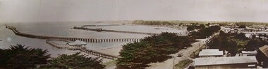
Mixed media - Photocard - Colour Panorama, Portland Bay, Colour Panorama, Portland Bay, n.d
... Trees along Bentinck Street. Telegraph Poles along Street. Truck... Cliff Street Portland great-ocean-road Displayed at History ...Displayed at History HouseTinted photo. Baths with blue roof in foreground. Fisherman's Wharf in background, Long Pier, Railway Pier, and Cypress Trees along Bentinck Street. Telegraph Poles along Street. Truck carrying bales. Mounted on cardboard.Front: Panorama of Portland, Victoria (Length of Ocean Pier, 2880 ft). -
 Bendigo Historical Society Inc.
Photograph - ESTELLE HEWSTON COLLECTION: COLOUR PHOTOGRAPHS BENDIGO TOWN HALL
... Street frontage facing Bull Street, taken in 1991 9B view... Inc. History House 11 Mackenzie Street Bendigo goldfields ...Two colour photogrphs of Bendigo Town Hall, 9A Hargreaves Street frontage facing Bull Street, taken in 1991 9B view of Bendigo Town Hall perspective of Hargreaves Street & parkland facades, taken 1996Estelle Hewston -
 Greensborough Historical Society
Vase, Cream vase, 1940s
... of Flinders Street and Degraves Street. It closed in 1965, and housed... in 1872 on the corner of Flinders Street and Degraves Street ...The Mutual Store, which sold this item, was Melbourne's first department store, which opened in 1872 on the corner of Flinders Street and Degraves Street. It closed in 1965, and housed the Council of Adult Education until about 2006. It is now apartments.Off-white vase with worn gilding around rim"Made in England for the Mutual Store Ltd Melbourne" Maker's name & logo illegible.vases -
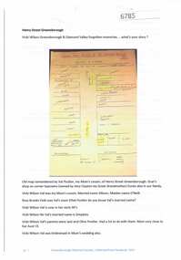 Greensborough Historical Society
Article and Photograph, Henry Street Greensborough, 2017_
... Henry Street Greensborough ...henry street greensborough...Map and information about Henry Street Greensborough, map... Street Greensborough, map drawn in 1999 by Valma Simpkins (nee ...Map and information about Henry Street Greensborough, map drawn in 1999 by Valma Simpkins (nee Poulter) of residents and businesses in Henry Street near Grimshaw Street in the 1930s. Further discussion about Poulter and Clayton family connectionsThis photograph and text was copied from a Facebook site. Members are people who lived in the Greensborough area and share their reminiscences of the area with others. The site is administered by a GHS member but is not officially affiliated with the Society. Any information is the opinion of the contributor. Article and photograph sourced from social media.henry street greensborough, valma poulter, valma simpkins, clayton family -
 Eltham District Historical Society Inc
Photograph postcard, Nearing the Station; postcard from Emily for Christmas
... york street...View looking north along Main Road from Bridge Street... melbourne View looking north along Main Road from Bridge Street ...View looking north along Main Road from Bridge Street to York Street. Shillinglaw Cottage and the Shillinglaw trees are visible in the centre distance. Possibly Sunday sightseers who have come out on the train from Melbourne. Digital file only Postcards scanned from the collection of Michael Aitken on loan to EDHS, 13 Feb 2018michael aitken collection, postcards, eltham, main road, shillinglaw cottage, shillinglaw trees, york street, bakery -
Tatura Irrigation & Wartime Camps Museum
bottles, unknown
... Cordial Factory on corner of Francis Street and Service Street...Tatura Irrigation & Wartime Camps Museum 49 Hogan Street ...all bottles found in old well on site of old Bartlett's Cordial Factory on corner of Francis Street and Service Street, Tatura opposite Lake Bartlett in 1999 by owners of the land who were clearing land to build units9 bottles, 7 glass and 2 pottery - 1)pottery, colour stone & light tan, inscription in black "drink good old ginger beer brewed by J. Bartlett & Co Tatura" and "This bottle is the sole property of J.Bartlett & Co. and must not be used by any other persons."|2)pottery, colour stone & brown, inscription in black "drink good old ginger beer made by J. Bartlett & Co Tatura" and "This bottle is the sole property of J.Bartlett & Co. Tatura" Stamped into pottery is oval stamp with words "Govancroft of Glasgow" and the number 1.|3)clear glass bottle with inscription in glass "J.Bartlett & Co. J.B. Rushworth & Tatura" and "This bottle is the property of J.Bartlett & Co" and "Lemonade" and a small number 2. On base is "M5 29, a symbol and M".|4)clear glass bottle with inscription in glass "J.Bartlett & Co. J.B. Rushworth & Tatura" and "This bottle is the property of J.Bartlett & Co" and "Lemonade" and a small number 2. On base is "M5 29, a symbol and M".|5)green glass bottle with marble in neck with inscription in glass "J.Bartlett & Co. JB & Co Trade Mark Rushworth & Tatura" and "This bottle is the property of J.Bartlett & Co" and "Lemonade" . On base is letter "M".|6)green glass bottle with inscription in glass "J.Bartlett & Co. J.B. Rushworth & Tatura" and "This bottle is the property of J.Bartlett & Co" and a small number 4 . On the base is letters M750, M and ACM.|7)clear glass bottle with inscription in glass "J.Bartlett & Co. J.B. Rushworth & Tatura" and "This bottle is the property of J.Bartlett & Co". On base is ACM.|8)clear glass bottle with inscription in glass "J.Bartlett & Co. J.B. Rushworth & Tatura" and "This bottle is the property of J.Bartlett & Co" and small number 1. On base is M749, M and ACM.|9)clear glass bottle with fancy pattern on neck with inscription in glass "J.Bartlett & Co. J.B. Rushworth & Tatura" and "This bottle is the property of J.Bartlett & Co". On base is L567, M and ACM.tatura, bartlett, drink, bottle, glass, pottery, industry, smith, reynolds, technology, bottles, ceramics, stoneware -
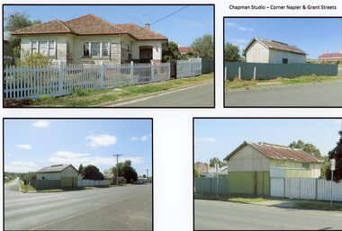 Stawell Historical Society Inc
Photograph, Mr W. J. Chapman -- Stawell Photographer's home on the corner of Maud and Grant Streets 2016
... of Maud and Grant Streets. 8 Maud Street which later... of Maud and Grant Streets. 8 Maud Street which later ...Home of W. J. Chapman Photographer of Stawell corner of Maud and Grant Streets. 8 Maud Street which later was renumbered 29 Grant Street. Photographic Studio back onto Grant Street. Photos Taken 2016.stawell business -
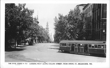 Melbourne Tram Museum
Postcard, Rose Stereograph Co, "Looking west along Collins Street, from Spring St. Melbourne", late 1930s
... "Looking west along Collins Street, from Spring St... turning from Collins Street into Mcarthur Street. Photo... Collins Street into Mcarthur Street. Photo is looking west along ...Rose Series postcard No. P 714 with W2 class tram 636 turning from Collins Street into Mcarthur Street. Photo is looking west along tree lined Collins Street. with two other W2's in the distance.Yields information about Collins St, late 1930sPostcard - printed real photograph with Rose Stereograph Co. name on the rear.tramways, trams, w2 class, collins st, tram 636 -
Glenelg Shire Council Cultural Collection
Photograph - Sheet of 12 contact prints - Various historic Portland buildings and Landmarks, c. 1970
... Beach with boats (b) 3rd Baths (c) Percy Street West, view from... Cliff Street Portland great-ocean-road Sheet of 12 contact ...Sheet of 12 contact prints of rephotographed photographs. Identifying number 5717 a, b, c, d, e, f, g, h, i, j, k, l (a) Nun's Beach with boats (b) 3rd Baths (c) Percy Street West, view from Henty Street (d) Percy Street, west, further along Street (e) Habrour from Whalers Bluff (f) Portland Gaol (g) Flagstaff and Lightkeepers Quarters, Observatory Hill (h) Claremont (i) First Portland Post Office building (j) Res Abraham Barrett, baker (k) Warehouses Trangmar & Crouch (l) Union Bank -
 Greensborough Historical Society
Map, Melbourne and Metropolitan Board of Works. Survey Division, MMBW, Yarra 2500 / 13.21. Central Greensborough, 1979_05
... , Municipality of Diamond Valley 257. Shows street names, easement sizes.... Shows street names, easement sizes, lot numbers, lodged plan ...Melbourne and Metropolitan Board of Works. Yarra 2500 [base map]. 13-21, Parishes of Keelbundora 2856 and Nillumbik 3310, Municipality of Diamond Valley 257. Shows street names, easement sizes, lot numbers, lodged plan numbers, names of prominent features, contour values, creek or river names. Central Greensborough. Prominent streets: Main Street, Para Road, St Helena Road and Diamond Creek Road.MMBW Map in 1:2500 [scale] series. Cream parchment with green tape reinforcing on edges and punched holes on left edge.mmbw, melbourne and metropolitan board of works, shire of diamond valley, greensborough - maps -
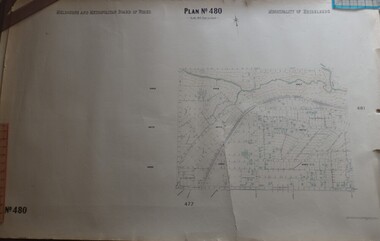 Greensborough Historical Society
Map, Melbourne & Metropolitan Board of Works, MMBW Plan No.480, 17/10/1949
... River in North to Grimshaw Street in South, Sellars Street... Greensborough, from Plenty River in North to Grimshaw Street in South ...MMBW plan of part of central Greensborough, from Plenty River in North to Grimshaw Street in South, Sellars Street in West to Kerr Street in East.Map shows buildings and topography for the area.MMBW plan, black and colour ink on beige parchment, 4 copies."Scale:160 feet to 1 inch"melbourne and metropolitan board of works, mmbw, greensborough -
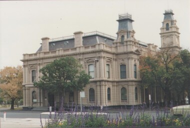
 City of Ballarat Libraries
Photograph - Card Box Photographs, Bailey's Mansion, Ballarat circa 1883
... Drummond Street North...Located on the corner of Drummond Street North and Mair...City of Ballarat Libraries Eureka Centre Eureka Street ...Located on the corner of Drummond Street North and Mair Streets is presently part of St John of God Hospital and has been built onto and around.bailey's mansion, st john of god hospital, drummond street north, building, private dwelling -
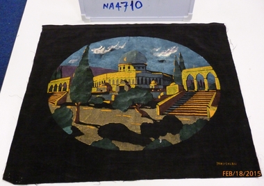 Whitehorse Historical Society Inc.
Domestic object - Cushion Panel, 1940s
... .|From the Returned Serviced League, Mitcham, 26 McDowall Street... McDowall Street (cnr Harrison Street) closed in early 2014 ...Item donated by R.W.T. Rowland, and was sent to the wife of a friend while serving in the 2/7th Battalion A.I.F. Middle East.|From the Returned Serviced League, Mitcham, 26 McDowall Street (cnr Harrison Street) closed in early 2014.Velvet square material 50cm x 40cm with 30cm x 40cm handpainted Oval Painting of the 'Blue Mosque in Jerusalem'handcrafts, hand painted, domestic items, furnishings -
Port Melbourne Historical & Preservation Society
Photograph - Friends of the Park float, Port Melbourne Festival, Pat Grainger, Feb 1989
... at Station Street carport, 88 Ingles Street: ?, Gary Ways (L), Amelia... Melbourne Town Hall 333 Bay Street Port Melbourne melbourne ...This float was created by members of Friends of the Park, a group formed in 1987 against government proposals to turn the railway and reservation into a grand boulevard to service the proposed Sandridge City 'bayside' development. Members worked for months to make the decorations, added to a trailer. During the festival procession sausages were BBQ'd on the trailer and handed out to the crowd. On arrival at Murphy's Reserve all floats were put out of sight, and few saw the results of their efforts.One of 16 photos of Friends of the Park float for the February 1989 Port Melbourne Festival: Float construction at Station Street carport, 88 Ingles Street: ?, Gary Ways (L), Amelia Finch (C), Anne Callaghan(R)celebrations fetes and exhibitions, public action campaigns, anne callaghan, gary, amelia finch, friends of the park, port melbourne festival -
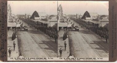 Linton and District Historical Society Inc
Stereograph, The Rose Stereographs, Melbourne, Sydney, Wellington and London, 12,924 Farewell Parade of the Australian Expeditionary Force, Coburg, Copyright 1914
... Long line of soldiers marching along a street in Coburg... marching along a street in Coburg Victoria. Street surface appears ...One of two sets of stereographs donated by the O'Beirne family along with a stereoscope for viewing (Stereoscope is Registration no. 2014-51).Long line of soldiers marching along a street in Coburg Victoria. Street surface appears to be dirt with tram lines running through the centre. Spectators standing on one side of the street. Horsedrawn vehicles travelling in opposite direction of troops."12,924. THE FAREWELL PARADE OF THE AUSTRALIAN EXPEDITIONARY FORCE. The Troops / Passing through Coburg, Victoria."stereographs, australian expeditionary force -
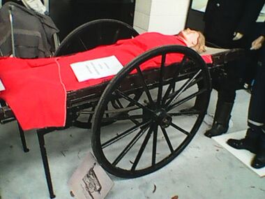 Ambulance Victoria Museum
Ambulance, Cart, Human Propelled, Ashford Litter, 1887
... at the Russell Street, Little Bourke Street, King Street and West...Ambulance Victoria Museum 1/55 Barry Street Bayswater ...in 1887 six Ashford Litters were purchased by St John Ambulance Association after Lady Janet Clarke (of Rupertswood) and her friends raised enough money to allow these items to be ordered. These were Victoria's first official ambulances. The litter consisted of a two wheeled undercarriage with elliptical springs which supported a stretcher. It has four legs which support the carriage when stationary but fold up to form handles so that one person could push the machine while another pushed. Four Ashford Litter ambulances were located at the Russell Street, Little Bourke Street, King Street and West Melbourne police stations. Another was located at the Melbourne Town Hall on Swanston Street and from 1896 the sixth was located at the Eastern Hill Metropolitan Fire Brigade station. Initially is was expected that police and fire fighters would take patients to hospitals if required.Two wheeled ambulance cart with sprung wheels.ashford, ashford litter, st john -
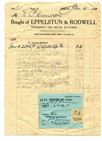 Orbost & District Historical Society
accounts, 1915 -1928
... in Nicholson Street (the main street), Orbost in the early 20th century....Orbost & District Historical Society Ruskin Street Orbost ...Robert Pullar Cameron was a Shire Councillor for many years. He married Penuel Hossack and had a family of James, Flora, Penuel and Alex. A. E. Rodwell was a wholesale and retail butcher in Nicholson Street (the main street), Orbost in the early 20th century.This document is a record of an early business in Orbost and reflects a time when accounts were hand-written. It is a useful research tool.Three accounts. One very yellow with block print and illustration of a bull in the top left hand corner. The other two are white with red lines and blue print. One has a blue receipt attached and a yellow duty stamp. They are from A.E. Rodwell, wholesale and retail butcher, to R. Cameron.document-accounts cameron-r.p. rodwell-a.e.-butcher -
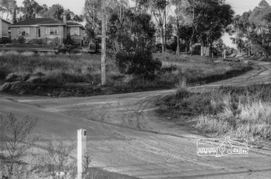
 Eltham District Historical Society Inc
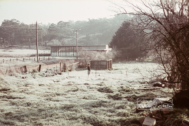
Photograph, Looking southwest from Eltham Shire Offices towards Shillinglaw Cottage, Henry Street and the tip site, c.July 1967, 1967
... Shillinglaw Cottage, Henry Street and the tip site, c.July 1967...henry street.... McD and 19/7/67. Alma Street and Kett Street Lower Plenty... J. McD and 19/7/67. Alma Street and Kett Street Lower Plenty ...Packaged in "Filmpro King Size prints Definitely Better EST. 1918" envelope. Pencil notes: 36 shots $2.87 Eltham Shire J. McD and 19/7/67. Alma Street and Kett Street Lower Plenty c.July 1967.Black and white photographeltham, eltham tip, shillinglaw cottage, henry street, streets -
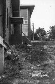 Eltham District Historical Society Inc
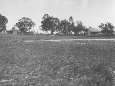
Photograph, The new Shire of Eltham Offices, opened 1965, c.July 1967, 1967
... . McD and 19/7/67. Alma Street and Kett Street Lower Plenty... J. McD and 19/7/67. Alma Street and Kett Street Lower Plenty ...Packaged in "Filmpro King Size prints Definitely Better EST. 1918" envelope. Pencil notes: 36 shots $2.87 Eltham Shire J. McD and 19/7/67. Alma Street and Kett Street Lower Plenty c.July 1967.Black and white photographeltham, eltham shire office, main road, shire offices -
 Eltham District Historical Society Inc
Photograph, Looking northeast up Alma Street from Para Road at intersection of Alma Street and Lees Road, Lower Plenty, c.July 1967, 1967
... Looking northeast up Alma Street from Para Road at...alma street.... McD and 19/7/67. Alma Street and Kett Street Lower Plenty... J. McD and 19/7/67. Alma Street and Kett Street Lower Plenty ...Packaged in "Filmpro King Size prints Definitely Better EST. 1918" envelope. Pencil notes: 36 shots $2.87 Eltham Shire J. McD and 19/7/67. Alma Street and Kett Street Lower Plenty c.July 1967.Black and white photographalma street, lees road, lower plenty, para road, houses, streets -
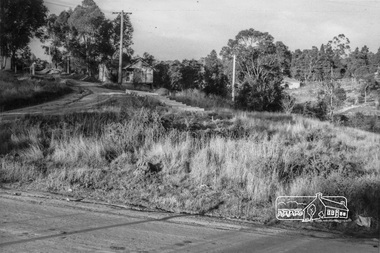 Eltham District Historical Society Inc
Photograph, Looking northeast up Alma Street from Para Road at intersection of Alma Street and Lees Road, Lower Plenty, c.July 1967, 1967
... Looking northeast up Alma Street from Para Road at...alma street.... McD and 19/7/67. Alma Street and Kett Street Lower Plenty... J. McD and 19/7/67. Alma Street and Kett Street Lower Plenty ...Packaged in "Filmpro King Size prints Definitely Better EST. 1918" envelope. Pencil notes: 36 shots $2.87 Eltham Shire J. McD and 19/7/67. Alma Street and Kett Street Lower Plenty c.July 1967.Black and white photographalma street, lees road, lower plenty, para road, houses, streets