Showing 2604 items matching " parts of buildings or structures"
-
 Conservation Volunteers
Conservator, Vol 24, No 1, Autumn/Winter, 2006 (Final Issue), Mr Colin Newell of FRP Printing Pty. Ltd, 9 Traminer Court, Wendouree 3355 has printed all CVA material from 1987-2010. Prior to this newsletters were photocopied inhouse, 1982
This set of magazines is a vital tool for those researching the early days and later development of ATCV and CVA. It was modelled loosely on the magazine "Conserver" of the British Trust for Conservation Volunteers (BTCV). Issues become more sophisticated in format over time and each includes news, project reports, lists of upcoming projects, and stories. The editor for 62 issues was Mr Alf Bailey (staff 1987-current (2010)who edited the Conservator from Mar 1987 to mid-2006.Alf was a former high school principal and set a high standard. Since 2006 a more compact and economical newsletter "Conservation Volunteer" has been mailed to CVA and CVNZ members and is also downloadable from the CVA website.This set of magazines is significant because it is the most comprehensive record of all aspects of the establishment, growth, expansion, and nature of ATCV/CVA and its activities. It reveals the change from a local charity to a nation-wide corporate structure engaging thousands of volunteers tackling hundreds of projects a year in Australia and New Zealand in the present day.This was the final issue of a magazine produced by ATCV/CVA from 1982-2006 (c. 90 issues). This issue was a high quality, profusely illustrated colour magazine, representing a quantum leap in professionalism from the earliest photocopied editions. magazine, conservator, conservation, volunteer, promotion, alf, bailey -
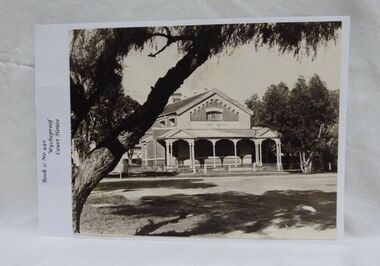 Wycheproof & District Historical Society Inc.
Photograph, Wycheproof Court House, (estimated); mid to late 19th century
The Court House opened as a court of petty sessions in 1890 and closed as a court in the early 1980s. It is now a 'Place of Deposit' for paper based products, maps, documents and photographs, and the home of the Wycheproof and District Historical Society Inc. The local Craft Group met at the Court House between 1982 and 2010. The Buloke Shire Council oversees the maintenance of the building.The Court House is No H 1656 on the Victorian Heritage Register. It is the one of only two buildings with this listing in Wycheproof, and characteristic of the type of building constructed in the early days of settlement in Wycheproof. The architecture is of aesthetic value and although some restoration work has taken place to maintain the structure, it remains in good condition and with some of the original furnishings intact.Sepia print of the Wycheproof-Court-House. It was constructed during 1889/90 and commissioned on September 23,1890 as a court-of-petty-sessions. A simple form of Court House built of red-face-brick but embellished by stepped brick work in the principal gable and by the traverse veranda with elaborate frieze and gabled pavilions that protect the street facade. The roof is of slate.Nonecourt house, wycheproof heritage 1890, petty sessions, building, red face brick, gabled pavilions -
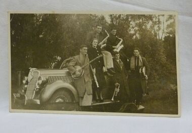 Wycheproof & District Historical Society Inc.
Photograph, Harrington, The Storey Dance Orchestra, (estimated); 1937/38
The Storey Dance Orchestra was formed in the 1920s by Arthur Storey, playing voilin & banjo, sister Rita-saxaphone,Jean and brothers Bob and Ben. Later, their mother, also Jean, an accomplished pianist and supporter of the orchestra, filled the pianist role after Jean left home to further her career. The car in the photograph was paid for with orchestra earnings. Their music involvement enabled a large family to sustain the farm during the 1920s and 1930s. World-War-Two intervened, this saw the Storey Orchestra disperse, Bob joined Jean in Melbourne, where they continued their musical careers. Ben joined the war effort, leaving Arthur on the farm. Con Taylor played on with a local Dance Band.The photograph tells of the important part that music played in the social structure of families and the wider community, and provided another means of income in the depression years of the 1930s.B&W print of the Storey-Dance-Orchestra, 1937/38, Ben Storey-banjo, Jean Storey-piano, Bob Storey-saxaphone-clarinet, Con Taylor-saxaphone, Keith Baker-trumpet, Jack Proctor-drums. The car,a Ford Rego.No Vic 21695 Noneclothing, musical instruments, storey, men women, dance orchestra, 1937 38, motor vehicles -
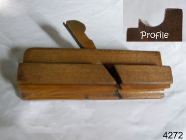 Flagstaff Hill Maritime Museum and Village
Tool - Wood moulding Plane, Edward Preston & Sons, Early 20th century
By the end of the nineteenth century, the firm of Edward Preston & Sons was founded in 1825, becoming one of England's leading makers of hand tools and in many ways a British counterpart to America's "Stanley" for its wide range of quality utilitarian tools at affordable prices. Edward Preston Sr. (1798–1883) was first listed as a plane-maker at 77 Lichfield Street in the Birmingham Directory of 1833, but later listings and advertisements assert that the business was started in 1825. Preston is likewise recorded as a plane-maker living with his family in Lichfield Street in the 1841 census, at which time his younger son Edward was 6 years old. Around 1850, his son Edward left school to join his father's business and is recorded in the 1851 census as a plane-maker at his father's address. He appears to have been quite a talented and resourceful young man, as he had later been able to start up his own "wood and brass spirit level manufacturing business at 97½ Lichfield Street by 1864. By 1866, Edward Jnr had added planes, routers, joiners, coach, gun, cabinet, and carpenters tools to his line, and the following year he moved his shop from his father's address and relocated to 26 Newton Street, before moving again to much larger premises at 22–24 Whittall Street. This location became known as the Whittall Works and later was the office and factory of Edward Preston & Sons, Ltd. In 1889 Edward Preston Jnr and his three sons were brought into the firm and the name was changed to Edward Preston & Sons, becoming Edward Preston & Sons Ltd on incorporation in 1898. Part of the firm's output was a healthy line of malleable and gun-metal planes and patent adjustable iron smoothers, shoulder planes, bull-nose, and block planes - a range that was expanded in later years. The 1901 catalog shows several styles of planes that were unique to the Preston brand, along with the usual styles which had already been set by other makers. The death of Edward Preston Jnr was reported in the Lichfield Mercury of 26 September 1913. "Mr. Preston was decided of an innovative turn of mind," the newspaper wrote, "as many of the machines in use at his works, as well as of the tools produced were the invention of himself and his three sons, who now manage the business." The report noted that at the time of his death, the business was carried on at Whittall Works, Cheston Street, Aston, Birmingham. Falling on hard times, the firm of Edward Preston & Sons was sold to the Birmingham firm of John Rabone & Sons in 1932, and shortly thereafter manufacturing rights to some of the Preston range of planes were sold to the Sheffield firm of C. & J. Hampton, who would later merge with the Record Tool Company. Some of the Preston planes were directly added to the Record line by the Hampton firm, while others were modified or discontinued altogether. Generally, all Preston wooden planes are stamped on the front of the plane, the shape, size, and character type of the stamp indicating the age of the plane. On some metal planes, all the parts were stamped with a number or symbol during manufacture. This number was used to re-assemble the parts following a batch process. Not all Preston tools are trade-marked clearly. Early shoulder, rebate, chariot planes, and chamfer rebates commonly appear without trademarks but may have assembly numbers. The "E P" trade-mark was already in use by 1882. The trade-mark "Preston" also appears on some later tools that were manufactured in Sheffield, England. These are generally smoothing planes and appear modern and very similar in construction to other modern manufacturers' planes.The item gives a snapshot of one of England's premier tool manufacturing companies at a time when significant industrial changes were occurring in manufacturing and business structures in the World that were beginning to affect social changes.Ogee wood moulding plane Maker E Preston & Sons No 5 (Owner A T Nipe) also has A's stamped on ends and the No 7flagstaff hill, warrnambool, shipwrecked-coast, flagstaff-hill, flagstaff-hill-maritime-museum, maritime-museum, shipwreck-coast, flagstaff-hill-maritime-village -
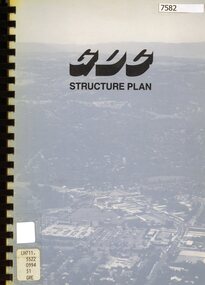 Greensborough Historical Society
Book - Planning Document, TTM Consulting Pty Ltd, Greensborough District Centre: Structure plan, 1989, 1989_07
A summary of investigations into impacts of the Greensborough District Centre in 1989, with plans for the development of the East side of Main Street Greensborough.91 pages text and black and white line drawings. One colour fold out map. Black plastic binding and clear plastic cover. greensborough district centre, main street greensborough, greensborough plaza -
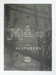 Mission to Seafarers Victoria
Flyer, Mission to Seafarers Victoria, Mission to Seafarers, c. 2012
Colour three parts foldable leaflet explaining the history of the Mission, the Flinders Street building and the ANL Art Prize. Leaflet available in the club room for visitors.mission to seafarers, marketing -
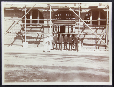 Mission to Seafarers Victoria
Photograph - Photograph, Sepia, Anne Treverton Goldsmith (nee Lobb), 1907
The Siddeley Street institute, designed by renown architect Walter Butler was built in 1907. The foundation stone was laid in February 1907 by Lord Northcote and the institute was opened in December the same year.The Siddeley Street Seamen's Institute is the first central structure to be built in central Melbourne on the banks of the Yarra River as the shipping was moving from Hobson's Bay to the city centre. Originally planned and budgeted for in the mid 1880s and petitioned by Ships masters in 1897 this was a long awaited project for the Mission.Sepia toned photograph depicting the Siddeley Street facility under construction. There are two women dressed in white wearing picture hats and carrying either cloaks or coats to the right of the photograph and a group of five men standing in a row beside them. They are all standing in front of the entranceway with arched windows to either side all of which is covered in scaffolding.Pencil mark on reverse of photograph: "2"siddeley street institute, australian-wharf, 1907, walter richmond butler (1864–1949), seamen's institute, seamen's mission, ladies, lhlg, officers, seamen, sailors, seafarers, mission to seafarers, scaffolding, anne treverton goldsmith (nee lobb -
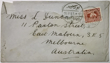 Mission to Seafarers Victoria
Letter - Correspondence, Letter to Lillie from Ted, 27 April 1928
This is one letter in a series of eighteen letters written by various seafarers to Lillie Duncan. Lillie was a member of the Ladies' Harbour Lights Guild and, as a Guild member, was strongly involved with the social activities and events organised to entertain visiting seafarers. The Ladies' Harbour Lights Guild was an integral arm of the fundraising that enabled the building of the Mission to Seafarers. These letters provide insight into a woman who was a member of the Guild as well as offering a glimpse into the social activities and courting rituals of the time.Handwritten letter consisting of four parts including an envelope and three pages of writing on front and back.Postmark on envelope: [indecipherable]/28.5 28.5/PORT SAID Company identifier on reverse of envelope: ANCHOR-BROCKLEBANK LINE/OF CALCUTTA STEAMERSletters, handwriting, 1928, mission-to-seafarers, stamps, lillie-duncan, ladies-harbour-lights-guild, lhlg, lillie duncan, ted, ss mandasor, port said, egypt, suez canal -
 Mission to Seafarers Victoria
Photograph - Photograph, Black and white, 1952-53
An historical visual record of some of the members of the Ladies Harbour Lights Guild, circa 1950. Many events run by the LHLG founded in 1906, were initially held in venues across Melbourne. In later years the main hall of the building opened in 1917 became a main venue for entertainment, meals and dancing. The LHLG organisation eventually amalgamated with the Flying Angels at the Mission circa 1962 and many LHLG members such as Dora Simpson, later elected as FA President went on to officiate.The Ladies Harbour Lights Guild (LHLG) a Melbourne and statewide network initially raised funds and held events for the Mission to Seafarers. Originally founded in 1906 the LHLG were responsible in 1917 for raising the funding for the Chapel and Dome at the Mission. The group and network developed a structure promoted to and adopted in one form or another by other similar auxiliary groups supporting Missions around the world. Black and white photograph. Image shows a number of women sitting in front of the stage in the main hall of the Mission to Seafarers Melbourne. In the background there is a three-piece band situated on the stage. Depicts the MtSV stage decorated with flowers, and lengths of material woven through an arch.The ladies seated in two rows in front of the stage all wearing summer dresses and have short hair styles typical of the 1950s Printed title and donor information printed across the top of the mount. See also historical informationpiano, drums, band, floorboards, stage, 1950s, dresses, main-hall, curtain, celebrations, lhlg, ladies harbour lights guild, mission to seafarers, seamen mission, mission to seamen, flying angel, melbourne, flinders street, prue leggoe, music, dance, entertainment, events, sailors, seafarers, seamen, lynette reynolds (nee madson), king george vi -
 Glenelg Shire Council Cultural Collection
Sculpture - Model - Portland Harbour, n.d
PORT OF PORTLAND COLLECTIONScale model of Portland Harbour in display case. Case: four sided, pyramidal, on collapsible legs. Portland Harbour Developmentportland harbour, scale model, structure, harbour development -
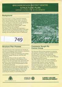 Greensborough Historical Society
Pamphlet, Shire of Diamond Valley, Greensborough District Centre, Structure Plan, 1988_
This was issued in 1988 calling for comments regarding the proposed development of the Greensborough Centre in 1988.This pamphlet has pictures of Greensborough as it was in 1988 and 4 concept plans for the proposed development.A 6 page folded pamphlet with green print on a glossy yellow paper.Nilgreensborough centre, 1988, diamond valley shire, lend lease -
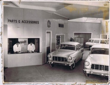 Greensborough Historical Society
Photograph - Digital image, Stubley Holden parts, 1960s
Stubley Holden dealership 1960s. The Stubley Group began in 1946 when Purcell Stubley purchased a site with petrol bowsers in Main Street from 'Snowy' Jessop. In 1948 Purcell began building the new Stubley Motors, working round the old site to keep the business operating. It was completed in 1951. The Group expanded into a Holden dealership in the 1960s.Digital copy of black and white photographpurcell stubley, stubley motors, stubley group greensborough -
Glenelg Shire Council Cultural Collection
Administrative record - Hire Purchase Agreement, c. 1939
From Aussie Velos: Alfred George Healing was born in 1868 in the suburb of Richmond, Melbourne (VIC). Starting in the cycle industry as a cycle builder and repairer in 1898, he obtained the Victorian agency for the English “Haddon” bicycle located on Bridge Road, Richmond. With many years behind him in the bicycle industry in 1907 he opened a small shop from borrowing £50 from his sister and began operating as A.G Healing. Importing bicycle parts Healing was quickly gaining a reputation for his quality and service among the cycling community, with steady business growth, Healing stumbled across an error that had been made in a recent order which resulted in twice the number of bicycle parts received. With no finances to pay for them, Healing decided to cycle around Victoria selling these parts to make the money he needed to fix up the order. As Healing travelled across Victoria he found that there was such a large market place for cycling gear that the order was soon fixed. It became apparent that Healing needed to open cycle shops in various locations. By 1912 Healing decided to open up his own proprietary company in Niagara Lane, Melbourne (VIC), the company was surging with enthusiastic cyclists and commuters and other branches began to spread all over state of Victoria. In 1921 Healing’s son Keith joined the firm and became an apprentice bicycle maker and Healing cycles grew more popular and at peak production 25,000 bicycles were made per year. Shops under the name of Healing were now operating across Australia. The business was now transferred to another location of Melbourne House, Post-office place (MELB). In 1926 Duncan and Co. wholesale and retail distributors of automotive parts was absorbed and was occupied in a larger building in Franklin Street (MELB) to maintain the warehouse operations. A.G Healing was now a public company. By 1933 the firm also began to specialize in importing radios and later began to make their own. One of the many Champions who rode on a Healing cycle was W.K “Bill” Moritz. His achievements included winning all major events in Australia and New Zealand during the years of 1936-37 path racing season. In 1936 Healing released a lightweight cycle that would rule in their supreme line-up, built from the lightest possible materials, the frame and forks were chrome plated, stripped for racing weighed exactly 16 1/2 lbs. It was fitted with special “Osgear” three-speed gear and built specially built for D. Byrant. By 1937, Healing cycles were being ridden by many, at the exhibition board track Jack Molloy won the Victorian ten-mile amateur championship, Bill Moritz captured the five mile professional, and Tassle Johnson the five-mile amateur scratch race. These wins brought up the total championships won in one week by Healing cycles to six.A hire agreement (hire purchase) between H.L. Vivian and R&G Finances Pty Ltd, for a Healing 'A' bicycle, with Eadie Coaster Hub brake. -
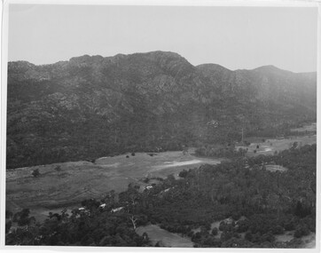 Halls Gap & Grampians Historical Society
Photograph
Photo depicts Fyans Valley. The road is The Grampians/ Dunkeld Road, leading to Dunkeld towards the right or Halls Gap travelling towards the left. Fyans Creek is visible in parts at the foot of the range (middle of Photo). Photo appears to have been taken from Bellfield Pk area. Photo is typical of those taken by Forests Commission of Victoria in the 1960sPhoto shows a mountain range in the background with a valley. The Valley has a band of a mostly cleared grassy section (middle of photo) with a fairly dense treed area in the foreground. A road and some buildings can be seen where the cleared land meets the treed area.scenery, fyans valley -
4th/19th Prince of Wales's Light Horse Regiment Unit History Room
Booklet, LHQ Press, Flame Warfare Pamphlet No 1 Parts I & II 1945, 1945
Soft covered booklet dealing with various aspects of the man-pack and AFV mounted flame throwersflame throwers, world war 2 -
4th/19th Prince of Wales's Light Horse Regiment Unit History Room
Folder, loose leaf, Manual of Land Warfare Part Three Vol 2 Pam 2 - Musorian Armed Forces 1980, 1980
Hard plastic loose leaf folder including Amdts 1 & 2. Publication is in four parts: 1. Musorian Country and Military Study 2. Technical Intelligence Digest 3. Conventional Warfare Tactics 4. Insurgency Warefarethe enemy, musoria -
4th/19th Prince of Wales's Light Horse Regiment Unit History Room
Document, Smith & Wesson Revolver .38, 1950's ?
Single page document, on one side drawings of the Smith & Wesson .38 detailing the various parts of the weapon, and, on the other side the same for the Colt Automatic .32pistol, revolver, smith & wesson, colt -
4th/19th Prince of Wales's Light Horse Regiment Unit History Room
Compendium of Booklets, RAC Training Armour Parts 1-5, 1970's
The five booklets of Royal Armoured Corps Training - Armour, in a loose leaf type hard coverrac training -
4th/19th Prince of Wales's Light Horse Regiment Unit History Room
Compendium of Booklets, Royal Armoured Corps Training Armour Parts 9 & 10
Two booklets Royal Armoured Corps Training Armour contained in a loose leaf hard coverWO Code 70032armour training -
4th/19th Prince of Wales's Light Horse Regiment Unit History Room
Information Sheet, Browning Machine Gun Calibre 0.50, 1970's
A photocopy information sheet produced by the Armoured Centre giving technical details and covering handling, stripping and assembly, care and maintenance and illustrating the various parts of the weaponbrowning 50 cal machine gun -
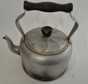 Kiewa Valley Historical Society
Kettle Aluminium, mid to late 1900's
This aluminium kettle was manufactured between 1940 to 1960's and replaced the heavier caste iron "open fire" stove ones (in doors or in the bush). A cast iron flat base between the open fires and the kettle was required. This kettle was used extensively with indoor open fire places. It was part of the evolution in "tea" making kettles. These were the only method of making hot beverages before introduction of electric kettles. For the Kiewa Valley the connection to the major electricity grid was post 1950's.This kettle is significant demonstrating the type of kitchen utensils required before electrical home connections became a reality. The aluminium structure of the kettle was an advancement over the heavier caste iron kettles. This type of kettle is still in use for bush and mountain hikers/climbers due to the light weight. This kettle was used by the Tawonga C.W.A. Branch. The C.W.A. motto "Honour our God, Loyalty to the throne, Service to the country, Through country women, For country women, By country women."This 99% aluminium hot plate kettle with lid (bakelite handle) is Australian made for flat stoves (cooking or room heating). It has a "tea style" spout and a bakelite hand grip(knob) on the top of the lid. The lid has nine ridges (for strength) radiating from the central hand grip. The two handle prongs are bop riveted onto the the body of the kettle. The bakelite hand grip has been fashioned to fit the natural contours of a clutching hand.On both sides of the aluminium handle "HOT PLATE WARE" and covering an oblique shaped triangle "99% PURE ALUMINIUM" and below that "MADE IN AUSTRALIA".Within the triangle "DURALIFE"cwa, homeware aluminium kitchen utensils, made in australia cook ware -
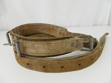 Kiewa Valley Historical Society
Belt Linesman Pole, circa mid to late 1900's
This linesman belt was used under the 1947 Electricity Regulations and before tighter Occupation and Health regulations (late 1990's early 2000's) were introduced that mechanical lifting platforms(wherever possible) replaced the belt up the pole method.The safety concern was that it required that tools needed by the linesman had to be placed in a large canvas bag and attached to the belt (extra weight) then the linesman had to climb the ladder. Ladders had to be at the correct angle and not able to "slip" from their initial footings. A full harness and a secondary fall belt is now mandatory for pole linesmen. The safety of fellow workers could be compromised if they were required to assist or recover the first linesman if needed. In 2006 an additional 269 registered lineworkers were employed. Please note that the terminology of linesman has become unisex. The linesman's belt enabled the linesman to place his feet against the pole adjust the belt (if needed) and lean back securely allowing both hands to be free to work with. This linesman belt is very significant to the Kiewa Valley due to the numerous poles and high voltage overhead power structures that needed maintenance for the extensive "mushroom" installation of electrical power polls(wood and metal). On high poles (steel) climbing pegs were welded on, however in the Alpine areas snow in winter caused an OH&S problem which were hard to overcome. The safety of a linesman when maintenance of electricity line on poles can be highlighted by the New Zealand linesman who survived an 11,000 volt shock when carrying out maintenance. For the record 11,000 volts is four times more powerful than execution by "the electric chair". The maintenance of the linesman's belt was his responsibility (keeping it clean and in "good" condition). Labour laws change this initial responsibility, from the linesman, to the employer. Climbing pegs were installed on higher poles that extended beyond the reach of ladders.This thick leather linesman belt is made from two lengths of heavy lengths of leather straps sewn together to make up 80% of the belt. The remaining 20% is "the belt tonge" which has eleven holes for three (solid steel tang) buckle connections.kiewa hydro electricity scheme, victorian state electricity commission, relays, generators, electrical pole maintenance -
 Kiewa Valley Historical Society
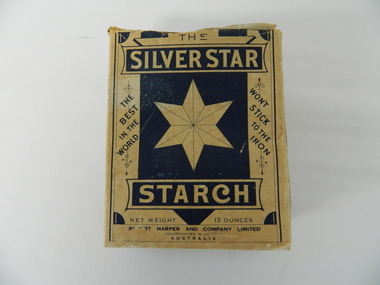
Box Starch, Pre decimal currency date(14th February 1966)
This brand of starch was first manufactured before 1966 and covered the period when Australian made was the preferred clothing due to limited imports from England. This was a period when the demand for "home grown" produce was at its peak. This was in a time when by necessity and ease of supply and not by the "Buy Australian" campaign (of later years), was the major factor for the demand of these type of laundry goods. It was in a time when starch was used in formal clothing to put a "crisp" or fresh new appearance for clothes. This product was in the era and importantly the social more of "clothes make the person" in which starched shirts and dresses was the fashion vogue. Formality of dress was a strictly British "class" up-man-ship which from the 1950's onwards became less and less visible. The Australian "Ocker" or fair "dink'm" bloke became more entrenched after World War II. The national identity was slowly developing.This box of starch is very relevant to the Kiewa Valley because this box highlights the differences ,in this period, between city and rural social standards. Rural areas were deeply entrenched into colonial and the pioneer family structure viz- a-vie social and dress fashion standards. British values and norms lingered on well beyond the changes happening in city fashion. Tradition and English "ties" were the backbone of early colonies and it was only after World War II that these "ties" were becoming irrelevant. Early traditions lingered well past the independence sought by Federation, colony to statehood and trade with other nations eg. USA and Asia. The idea that a change in "status" would automatically change the social mores of Australians, especially in rural ares, was not fully grasped by the "law makers" and those wanting change.This box (capacity 12 ozs) has white(aged into cream) and blue printing and a "white star" on five sides, the sixth side has a laundry scene with two ladies, in early 1900's fashion. The package is made from 200 gsm thick cardboard. As manufacture was made before and during the two World Wars 1914 to 1945 the promotion was heavily focused on Australian made and Australian grown maize. One side of the box has instructions of use and all the other sides are promotional, detailing "the best in the world and won't stick to the iron""SILVER STAR", "THE BEST IN THE WORLD", "WON'T STICK TO THE IRON", "REQUIRES NO BOILING", INSTRUCTIONS FOR USE", "ROBERT HARPER AND COMPANY LIMITED", "INCORPORATED IN VICTORIA, AUSTRALIA", "NET WEIGHT 12 OUNCES", "LARGE BOX 12 OZS"domestic laundry essentials, cotton clothing preparations, household starch "crisp and neat appearances. -
 Kiewa Valley Historical Society
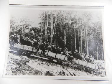
Photos - Box of 6, A3 size, Rubicon Scheme Construction
S.E.C.V. scheme prior to Kiewa Hydro Electric Scheme (and features in the SECV magazines.6 photos stored in yellow Kodak box. 1. Original Rubicon Falls Power Station Woodstave Pipeline Replaced since with steel pipe. B & W photo Est. 1940. 2. Original Wall of Eildon Weir was Submerged when new wall & new Power Station was built in Mid - Late 1950s. 3. B & W photograph of Rubion Falls Power Station under construction late 1920's - Early 1930's 4. Royston Woodstave Pipeline under construction parts of the pipeline are still in service Photo set. 1932 Timber used is Canadian Spruce 5.Rubicon Power Station in Foreground Construction buildings in background Rubicon Scene - late 1920's - early 1930's 6. Haulage Rubicon estimate mid-late 1920's. The means of transport to civilisation for the working parties constructing the Rubicon Scheme1.A.N. 427To R.J. Wegener Station Engineer. Rubicon Area 2. A.N. 429 3. A.N. 435 4. A.N. 436 5. A.N. 425 6. A.N. 437 rubicon scheme. woodstave pipe. rubicon pipeline. r.j. wegener. eildon weir. royston. canadian spruce. rubicon power station. rubicon haulage. state electricity commission of victoria. -
 Kiewa Valley Historical Society
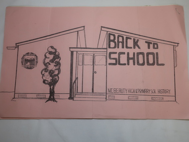
Papers - Mt Beauty High School No.4644, Back to School - Mt Beauty High and Primary School History. See also KVHS 0833
10 points of history pertaining to the History of Schooling in Mt Beauty from 1947 when the SECV and the Education Department erected the school as the population of Mt Beauty grew.A detailed account of the history of schooling at Mt Beauty. Mt Beauty was a construction town run by the SECV when building the KHES.Pink front cover followed by 5 pages of foolscap papers with staple in top right hand corner. Title in black print. In two parts - 1. State School No. 4644 Mount Beauty / Some (10) Points from the School History 2.Mount Beauty High Schoolmt beauty state school, school no. 4644, education -
4th/19th Prince of Wales's Light Horse Regiment Unit History Room
Document, John W Parker, Extracts from Regulations for Conducting Musketry Instruction of the Army, 1859
Issued to instructors and the volunteers, detailing the drill, procedures and training to be followed by regular infantry and volunteers equipped with the Enfield type rifle or carbineA photo copy of the publication, which is a facsimile of the original publication. A selection of parts of the original publication relating to stripping, cleaning and aiming of the Enfield rifles and copperplate engravings of the lock parts and carbine accessories.musketry training 1859 -
4th/19th Prince of Wales's Light Horse Regiment Unit History Room
Document, Smith & Wesson Revolver .38/Colt Automatic .32, 1940's ?
A double sided document showing the weapons and their parts in cut-away diagramssmith & wesson, colt, pistols -
4th/19th Prince of Wales's Light Horse Regiment Unit History Room
Booklet, Defence Printing Esatblishment, Field Engineering Pam 7 Booby Traps Parts 1 & 2, 1972
A soft covered booklet providing a basic knowledge of the principles involved and the mechanisms used in booby traps.DSN 7610-66-048-1189field engineering, booby traps -
4th/19th Prince of Wales's Light Horse Regiment Unit History Room
Photograph, c. 1914-15
A black & white photograph of an old stone wall, parts of which have been destroyed. The wall is heavily overgrown in part and there is rubble scattered about.Standing near an arch in the wall is a man in German uniform.On the back: " ? Kress Von Kressentine ?"photo, kressentine -
4th/19th Prince of Wales's Light Horse Regiment Unit History Room
Post cards, J Williams, c. 1918
Five black & white post card pictures showing parts of the Western Front. They are: 1. Peronne - Aspects of the town entirely destroyed by the retreating Germans, 2. The village of Feuilleres (Somme) (destroyed) , 3. Estrees (Somme) - Entrance of the village, 4. Neuve Eglise (destroyed) and, 5. La Buissiere, La Gare1,2,&3 Vise Paris No 853, 867 & 863 and description of location. 4 & 5 - location onlyphotos, western front