Showing 23714 items
matching creeks
-
 8th/13th Victorian Mounted Rifles Regimental Collection
Photograph
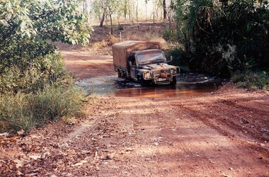
The Dibb Report into mainland defence of Australia,1986, among other things identified the requirement for protection of key assets in Northern Australia and the possibility of involving Army Reserve (Ares) units in this thus releasing regular forces for offensive operations. Dibb also pointed out that this defined role would result in a huge lift in Ares morale. In June 1988, the 3rd Division (3Div) conducted a Tactical Exercise without Troops (TEWT), Exercise ‘Distant Trumpet’ in the Katherine- Darwin area to study problems associated with defence against low level incursions against Tindal RAAF Base. Exercise ‘Northern Explorer’ followed in October of that year when units of the 3Div including A Squadron 8/13 Victorian Mounted Rifles sent patrol groups to get a first taste of environment and conditions. Post-Exercise reports had to include recommendations re: health, equipment and adaptation of Standing Operating Procedures (SOPs) in preparation for the new role deploying to Northern Australia. The first deployment by 8/13 Victorian Mounted Rifles was in 1988. Deployments continued in following years. In September 1993, 3 Troop (Wangaratta) VMR Squadron 4/19 PWLH commanded by Captain Kelvin Robertson deployed to NT. The training began with airfield defence at Tindal followed by a 1000km recon into Arnhem Land in four Landrovers. The troop reported on the conditions of the roads, airfields, bridges (mainly causeways) resources such as fuel supplies in the towns and infrastructure. Each troop taking different route. 3 Troop had the Northern route through Kakadu National park across the East Alligator River to Oenpelli then to Maningrida and Ramangining and south to the Central Arnhem Road and back to Tindal Air force Base. Two colour photographs of creek crossings, one more challenging than the other,during the annual exercise in Northern Territory, conducted by VMR Squadron 4/19 Prince of Wales's Light horse, 1994. -
 Southern Sherbrooke Historical Society Inc.
Plan - Plans for Proposed Sports Pavillion and Scout Hall at Menzies Creek
Two copies of sketches for a proposed sports pavilion and Scout Hall at Menzies Creek, from multiple angles (front, side and rear). All sketches are at 1:100 scale. Includes floor plan of the building. -
 Southern Sherbrooke Historical Society Inc.
Photograph - Photo, Menzies Creek Station
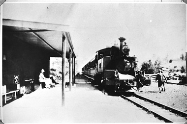
Photograph of Gembrook train (Puffing Billy) arriving at Menzies Creek Train Station from Belgrave. A woman and a man (?) are seated at the station. Two boys run along the far side of the track. Date unknown, -
 Southern Sherbrooke Historical Society Inc.
Photograph - Photo-black & white-Puffing Billy track and water tower
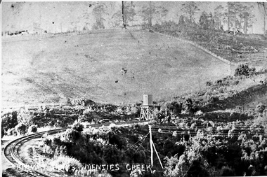
Photograph of the railway line to Gembrook and the water tank at Menzies Creek in the centre of the picture. This area, known as The Tanks, is the site of the landslide that closed the railway down in 1953. Glen Park homestead is on top of the hill on the left. -
 Southern Sherbrooke Historical Society Inc.
Photograph - Photos of house and land at 12c Black Hill Rd, Menzies Creek
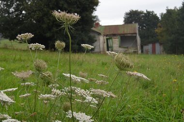
Photographs of the house and land at 12c Black Hill Rd, Menzies Creek, taken by Chris Girvan in 2011. Features the run-down, abandoned interior and exterior of the house (missing glass pane windows), and shed. -
 Bendigo Historical Society Inc.
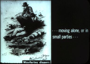
Slide - DIGGERS & MINING. DIGGERS AND MINING, c1852
Diggers & Mining. Diggers and miners. - - - moving alone, or in small parties - - - Slide: STG Wayfaring Diggers 1852. Two diggers resting by a creek. Markings: 40 994:LIF I. Used as a teaching aid.hanimounteducation, tertiary, goldfields -
Tarnagulla History Archive
Christopher letter, 1860 (original letter)
Donald Clark Collection.Two identical photocopies of a four-page letter written by a resident of Sandy Creek (Tarnagulla). Appears to be from a person with surname Christopher to a Miss Mary Christopher (the author's sister). Dated April 16, 1860. -
 Department of Health and Human Services
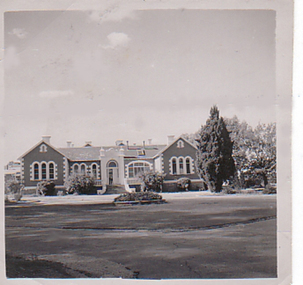
Photograph, Front of building and roundabout of Pleasant Creek Special School - Stawell - Circa 1940 to 1950
Pleasant Creek Colony history in brief Warning about distressing information Patient information Disclaimer Source On this page: Pleasant Creek Colony history in brief Warning about distressing information Patient information Disclaimer Source Pleasant Creek Colony history in brief In 1861, the Pleasant Creek Hospital opened as a medical facility for the population of Stawell and district. Another building was added in 1904, Syme Ward for convalescent patients. In 1933, the facility was replaced by a newly-built hospital in the town of Stawell. In 1934, the Mental Hygiene Department acquired the old Pleasant Creek Hospital site and converted it to accommodate children with disabilities, which became Pleasant Creek Special School. The first residents (18 boys) were admitted in 1937 from Royal Park Depot. At the end of 1937, there were 98 children living at Pleasant Creek. In 1968 the Pleasant Creek Special School was renamed Pleasant Creek Training Centre, caring for people with intellectual disabilities. From the 1950s to the 1980s, there were several building developments: •1957, Lonsdale Unit expanded capacity to 113 •1969, Bellfield and Fyans Units increased numbers to 196 •1977, Alexandra Unit converted to recreational and lecture room facility. •1977, Day Centre, Nurses' Home and Clinical Services Administration buildings •1985, Nara Unit closed for renovations and residents moved to the previous staff living quarters. https://www.findingrecords.dhhs.vic.gov.au/CollectionResultsPage/Pleasant-Creek-Colony -
 Halls Gap & Grampians Historical Society
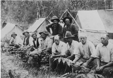
Photograph - Sepia, C 1909
Grampians halls Gap at Stoney Creek Dredge. The site of the Stoney Creek diggings was in the upper catchment area of the creek, beside Silverband Road. For further information see: 'Bridging the Gap' by Ida Stanton, p. 49 and 'Victoria's Wonderland' by Halls Gap and Grampians Historical Society, p. 41.Photo shows eight men seated, two standing, 3 tents in background. 2nd right Alfred D'Alton 4th Right James Oliverwater supplies, d'alton, water supplies, channels -
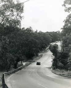
 Eltham District Historical Society Inc
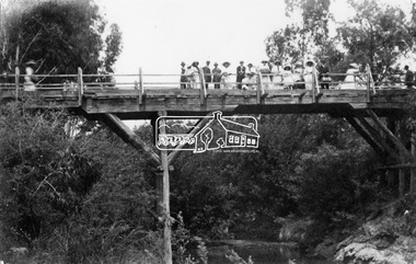
Negative - Photograph, Hurst's Bridge, c.1912
The area of Hurstbridge was originally known as Hurst’s-bridge after the timber bridge built over the Diamond Creek near Hurst’s station in late 1881/early 1882. A large group of people can be seen strolling across the timber bridge over the Diamond Creek on Hurstbridge-Arthurs Creek Road, Hurstbridge. It was built by John McDonald, of Arthur's Creek and was demolished and replaced in 1917 by a reinforced concrete arch bridge designed by John Monash.This photo forms part of a collection of photographs gathered by the Shire of Eltham for their centenary project book, "Pioneers and Painters: 100 years of the Shire of Eltham" by Alan Marshall (1971). The collection of over 500 images is held in partnership between Eltham District Historical Society and Yarra Plenty Regional Library (Eltham Library) and is now formally known as 'The Shire of Eltham Pioneers Photograph Collection.' It is significant in being the first community sourced collection representing the places and people of the Shire's first one hundred years.Digital image 4 x 5 inch B&W Negshire of eltham pioneers photograph collection, 1912, bridge, diamond creek (creek), hurstbridge, hurst's bridge -
 Falls Creek Historical Society
Magazine - Fall-Line - Australia's National Skiing Magazine April '79, April '79
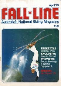
“Fall-Line” was one of a series of magazines published by the Victorian Ski Association. It was produced from 1979 until 1985. It superseded their previous publication, “Ski” magazine and was followed by the “Australian Skiing” magazine. The Victorian Ski Association was formed in 1955.This magazine is significant because it documents developments in the ski industry in Australia.A magazine featuring a coloured image on the cover and containing articles and advertising related to developments in skiing in Australia. This issue included an update on improvements being made at Falls Creek. FALLS CREEK The chairlift access area near the medical centre, long famous as the Mudpie Parlour of Falls Creek, has been sealed and Falls Creek itself, the waters of which have filled many an unsuspecting gum- boot, has been bridged, also near the medical centre. A lock-up storage shed will be built along Bogong High Plains Road, just below the oversnow terminal, for the use and convenience of all village commercial operators and site holders. Direct access will be possible by snowmobile. Falls Creek rates have risen to $82.50 per bed (less 10% discount if paid on time). The rise is the first in two years, and is less than the corresponding rise in the C.P.I. over that period. The access trail from the water tanks at the base of the Home Trail to the nursery slope has been smoothed and widened to 12 metres, and a new six metre wide access trail has been cut from Falls Creek Road, just behind Diana lodge to the chairlift bottom station. The Village Bowl comfort station is being extended and renovated, and the finishing touches are being put on the comfort station in the upper car park. Construction of an akja station/toilet block in Sun Valley will commence in 1980. The Management Committee is investigating the purchase of a Mercedes 800 series snow-clearing machine to supplement the CRB equipment in use in village parking areas The village water supply has been re- designed to ensure adequate supply at all times.australian ski magazines, skiing australia, victorian ski association -
 Falls Creek Historical Society
Magazine - Fall-Line - Australia's National Skiing Magazine July - Aug 1979, April '79
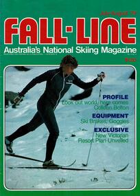
“Fall-Line” was one of a series of magazines published by the Victorian Ski Association. It was produced from 1979 until 1985. It superseded their previous publication, “Ski” magazine and was followed by the “Australian Skiing” magazine. The Victorian Ski Association was formed in 1955.This magazine is significant because it documents developments in the ski industry in Australia.A magazine featuring a coloured image on the cover and containing articles and advertising related to developments in skiing in Australia. This issue included an extensive article discussing the possible of the development of Lakeside Resort on the shores of Rocky Valley Dam as well as an update on recent changes at Falls Creek. FALLS CREEK The ski patrol has been increased from seven to eight, under the leadership of Senior Patroller John McDonald, and two new radios have been purchased. A four wheel drive ambulance has been purchased to replace the old conventional drive model. It will provide free ambulance transport between Falls Creek and Mt. Beauty, and will be driven by trained volunteer personnel. A new 165 vehicle day visitor car park has been completed at Windy Corner, adjacent to the approved toboggan slope. The closest car park to Falls Creek's Nordic Preferred Area, its capacity will be doubled next summer. A planning permit has been issued to Treglor Pty. Ltd. for its proposed hotel/convention centre. Construction is expected to begin after the season. A new Mercedes 800 tractor with Schmidt Snowcutter recently arrived on the mountain and will be used to clear the car parking areas Falls Creek continues to be among Australia's most expensive resorts, with a high season day ticket price of $13.50. Falls Creek's newest commercial lodge, Lakeside Lodge, has opened with accommodation for more than 50 people and luxury facilities including private rooms with full ensuite, sauna, spa pool, and a dining room for guests. It is located at the top of Schuss St. just behind Imaj flats and very close to the village bowl.australian ski magazines, skiing australia, victorian ski association -
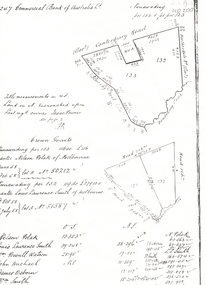
 Ringwood and District Historical Society
Map - Public Land Sale by Thomas Ham, 2000 Acres for Sale - Crown Sections 20, 23, 24 - Ringwood, Victoria - 1855
Two 1850s surveyor's maps on cardboard backing showing area from Melbourne extending East beyond Bulleen and Nunawading. Detailed description of lots for sale and navigational directions to the property from Richmond by Thomas Ham, Victorian public servant, map maker, publisher, lithographer and original Ringwood land owner. Inset map enlarging area between Yarra River and Dandenong Creek, with southern boundary of allotments later forming part of Oban Road, North Ringwood.TRANSCRIPT: "This really valuable Property is now offered to the public for sale, in lots to suit purchasers at the Iow rate of £1 per Acre for 80 acres and upwards, and £1.10s per Acre for any smaller portion. Terms of payment Half Cash, Balance in 6 and 12 months, bearing 8 per cent interest. The Estate is well wooded with Gum, Cherry Tree and Stringy Bark, with Wattle in the valleys of the several creeks. Every lot is Staked and Trenched at the corners marked on the Plan thus - The Surveyor has carefully sub-divided the Property, in order to give every Farm a Creek for Water, Valley for Cultivation, and Hills for House and Grass Paddock. The ROADS have been very carefully laid out so as to give a firm, well drained, and nearly level road to each Homestead. Intending purchasers can readily find the property by the following directions, viz: Start from Richmond Bridge, at Hawthorne, then take the left-hand road to KEW. When at the "Woodman Inn", take the Cotham Road to the right, bearing due east, keep this Road, passing Trainor's "White Horse" Inn, and before you leave the fences, you will see calico bills (see margin) nailed to the Trees on the bush track leading to the Upper Yarra country, follow the Bills till you come to the SOUTH boundary line of the Property, which bears East and West (see Plan) where you will see Bills nailed up "THIS PROPERTY FOR SALE, etc." The Bills from Town lead direct to where Mr. Jull is erecting his Store, and arrangements have been made with him to show the lots to intending purchasers free of charge. At the respective corners of the lots the Bills are nailed up double, with numbers to denote the lot, and that the corner stake is adjacent. Any parties wishing to proceed to the property by way of BULLEEN will find Bills nailed on the Trees, commencing at the NEW INN, at "Wilson's Slip Rail." Keep this Track till you come to the Log Bridge, over the Deep Creek at Bloxhome's Paddock; go through the land now being cleared; keep the track over the hill till you come to an Iron House, you will then be on the property, which Iies to the North and East as per Plan. Follow the Bills till you come to Mr. Jull's Store, etc. etc. Further particulars can be had from the Agent for the Property. THOMAS HAM. " -
 Greensborough Historical Society
Map, Keelbundora. Counties of Bourke and Evelyn, 1950_11
Covers area bounded by Merri Creek, Yarra River, Plenty River and Crown Portions 24 to 28, with section including Maroondah Aqueduct and Darebin Creek.Photocopy of digitised mapkeelbundora (parish) -
 Ballarat Heritage Services
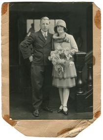
Photograph - Black and White, Gus Gervasoni and Elizabeth Gervasoni (Hogan), 1929
George (Gus) Gervasoni was the son of George Gervasoni of Yandoit Creek/Daylesford, and grandson of Luigi Gervasoni of Yandoit Creek. Elizabeth Hogan was born in Inglewood, VictoriaBlack and white photograph of Gus Gervasoni and Elizabeth Hogan on the occasion of their marriage. gus gervasoni, elizabeth gervasoni, bess gervasoni -
 Eltham District Historical Society Inc
Photograph, 1934 Floods at Eltham
Published in the Diamond Creek Basin Study, 1980 and identified at Diamond Creek, locality not identified, 1934. The location is actually looking south across the Diamond Creek towards Falkiner Street, beside the Main Road bridge at Eltham South from what is now part of Wingrove Park opposite Antoinette Boulevard. The bridge railing is just visible to the left of image. The large leaning Manna Gum beside the bridge still stands in 2021 alongside the Diamond Creek trail. In 1934 extensive flooding of the Yarra River and Diamond Creek set new records for flood plain level (Eltham Chronology, EDHS)Black and white photographCopied by Hugh Fisher, Photographer, 6 York Street Eltham A1678B Floods- Eltham - 1934floods, yarra river, eltham, flooding, diamond creek, flood -
 Eltham District Historical Society Inc
Negative - Photograph, J.A. McDonald, Hurstbridge Water Scheme, 11 May 1961
Weir on Running Creek at Map Ref YAN YEAN 249699 11 May 1961 Reading 8” V http://wikimapia.org/10473910/Running-Creek-ReservoirRecord of various Shire of Eltham infrastructure works undertaken during the period of 1952-1962 involving bridge and road reconstruction projects, sometimes with Eltham Shire Council Project Reference numbers quoted. It was during this period that a number of significant improvements were made to roads and new bridges constructed within the shire that remain in place as of present day (2022). In many situations, the photos provide a tangible visible record of infrastructure that existed throughout the early days of the Shire. The album was put together by or under the direction of the Shire Engineer, J.A. McDonald.infrastructure, road construction, shire of eltham, 1961-05-11, hurstbridge water scheme -
 Greensborough Historical Society
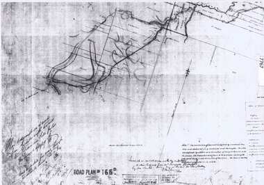
Document - Road Plan, Road acquisition, St Helena Road, 1859, 1889
Road plan showing land acquisition for the road to Diamond Creek (NOT Diamond Creek Road), also known as Eltham Road and now known as St Helena Road.Shows the land through which St Helena Road runs, with original owners marked on plan.1 page. Copy of road planroad plans, st helena road greensborough, diamond creek -
 Lake Bolac & District Historical Society
Black and white photograph, Fiery Creek Entrance
Fiery Creek inlet to Lake Bolac during the 1997-2010 drought. Photograph taken from the dry lake-bed looking up the creek, towards the south.lake bolac, fiery creek, 1997-2010 drought -
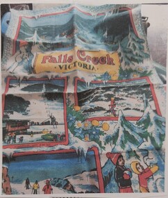 Falls Creek Historical Society
Souvenir - Tea Towel
Marketing material for Falls Creek from the 1980s. The illustrations were made from photographs of Falls Creek. It was produced by S K Pierce who built Snowland. Fabric tea towel with illustrated snow scenes across the towel, showing the snow fields. These images were mostly taken from photos and include T children making a snow kangaroo and people skiing. One main image with smaller images framed in red. The image of a man looking down the summit is Limi Leitch who owned the Box Hill Ski Hire Shop. The towel was designed by S. K. Pierce who built Snowland.falls creek, souvenir, 1980s advertising, snow, snow fields, snowland -
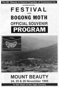 Kiewa Valley Historical Society
Papers - Community Newspapers and newspaper cutting, This Week & Bogong Moth Festival
The Festival of the Bogong Moth was run by the Mt Beauty Chamber of Commerce under the directorship of Yvonne Evans. It was a highly successful event which took place in November in both 1994 and 1995.In 1994 and 1995 it was very under appreciated as to the significance of the Bogong moth and the Aboriginal people to this area and failed to continue due to lack of community support.This Week newspaper x3 covering Falls Creek and Mt Beauty containing a program for the Bogong Moth Festival November 1995. Newspaper cutting from Regional Extra advertising the Bogong Moth Festival November 1994bogong moth festival, mt beauty chamber of commerce -
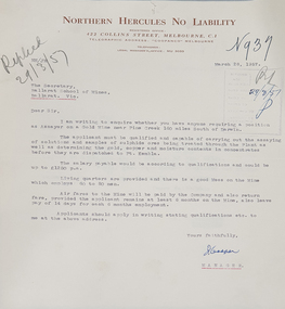 Federation University Historical Collection
Letter, Letter from Northern Hercules No Liability to the Ballarat School of Mines, 28/03/1957
Many mining companies sought staff from the Ballarat School of Mines.Typed letter on Northern Hercules No Liability letterhead asking for a qualified assayer to work at the Pine Creek Gold Mine 160 miles south of Darwin. The letter was responded to by R.W. Richards, Principal of the Ballarat School of Minesballarat school of mines, northern hurcules no liability, northern territory, mining, letterhead, r.w. richards, dick richards, mining companies, assayer -
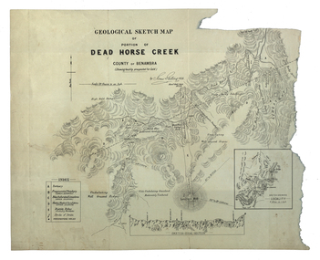 Federation University Historical Collection
Map, Dead Horse Creek, 1887, 29/05/1887
Geological sketch map of a portion of Dead Horse Creek. WGS 84 Centroid Lat: 36 degrees 50 inches S Long: 148 degrees 00 inches S NS: 4.3km EW 4.8kmdead horse creek, james stirling, gold, geology, mount cobberas -
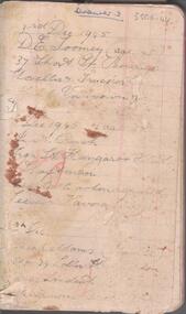 Bendigo Historical Society Inc.
Document - CENTRAL DEBORAH GOLD MINE EMPLOYEES NAMES 1945 TO 1948
Small notebook, lined pages. Names, addresses and mining experience listed in pencil. Dates range from 1945 to 1948. Page near back of notebook details Spargo Creek Mine expenditure and shaft team.bendigo, mining, central deborah gold mine -
 Bendigo Historical Society Inc.
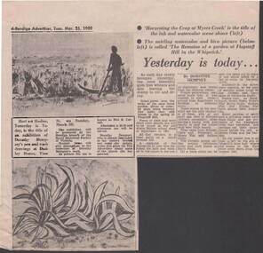
Newspaper - NEWSPAPER ARTICLE: YESTERDAY IS TODAY
25.3.1980 Newspaper article 'Yesterday is today ' by Dorothy Dempsey 'Yesterday is today ' - the title of an exhibition of her pen and wash drawings. Shown are pictures of 'Harvesting the Crop at Myers Creek ' and The Remains of a garden at Flagstaff Hill in the Whipstick 'newspaper, bendigo advertiser -
 Whitehorse Historical Society Inc.
Legal record - Land Title, Crown grant, 1858
Commercial Bank of Australia record of Crown Grants of land to Nelson Polak and Louis Laurence Smith in 1858.Commercial Bank of Australia record of Crown Grants of land to Nelson Polak and Louis Laurence Smith in 1858. The land is between Canterbury Road, Heatherdale Road, 'Scoresby Road' (now Boronia Road) and the Dandenong Creek.Commercial Bank of Australia record of Crown Grants of land to Nelson Polak and Louis Laurence Smith in 1858. polak, nelson, smith, l l dr, canterbury road, vermont, boronia road, dandenong creek, heatherdale road, land sales -
 Whitehorse Historical Society Inc.
Photograph, Deep Creek Road, Mitcham, 1/01/2001 12:00:00 AM
Black and white photograph of Deep Creek Road, Mitcham taken from lower entrance of Schwerkolt Cottage Reserve showing Glenvale Road on left. Photo taken before work started on new road and bridge.deep creek road, mitcham, glenvale road, ringwood -
 Lakes Entrance Regional Historical Society (operating as Lakes Entrance History Centre & Museum)
Photograph, 2012
Date made December 2012Colour photograph of the railway bridge over Boggy Creek at Nowa Nowa. Bridge is built on combination of solid concrete piers, timber trestle piers on concrete to flood level, and timber piers. Nowa Nowa Victoriabridges, waterways, transport -
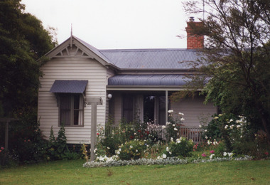 Lakes Entrance Regional Historical Society (operating as Lakes Entrance History Centre & Museum)
Photograph, 1999
Built 1896c. provided guest house accommodation and bed and breakfast since being established.Colour photograph of a substantial weatherboard dwelling at 3 Rosherville Road, hipped and gabled roof of corrugated iron. Located in garden setting above Chinaman's Creek and known as Metung House since establishment. Metung Victoria.houses, heritage study -
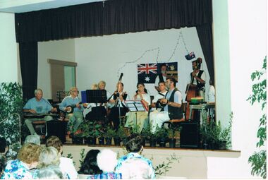 Bendigo Historical Society Inc.
Photograph - PETER ELLIS COLLECTION: BUSH BAND
Colour photograph showing a band on stage playing in front of a small crowd. Guitar. Banjo. Recorder. Concertina. Australian Flag. Back of photo reads: Emu Creek Bush Band Australia Day Concert Goornong.photo, group, musicians